interface for communication between agents.
class for communication management.
Agent Factory: class for agent creation.
Agent Directory: class for agent registration.
Agent Behavior: abstract class for agent behavior definition.
Concrete Agent: concrete agent implementation.
The core of the architecture is based on three main classes:
- Manager - represents the highest level of hierarchy, manages lower level agents.
- Agent - represents basic autonomous entity, encapsulates behavior and communication.
- Structure - represents geographical area, contains reference to lower level agents.
Agents are organized hierarchically according to geographical areas they represent. Manager is
the root of hierarchy, structures represent areas and agents are located
Online Bus Arrival Time Prediction Using Hybrid Neural Network and Kalman fil...IJMER
International Journal of Modern Engineering Research (IJMER) is Peer reviewed, online Journal. It serves as an international archival forum of scholarly research related to engineering and science education.
International Journal of Modern Engineering Research (IJMER) covers all the fields of engineering and science: Electrical Engineering, Mechanical Engineering, Civil Engineering, Chemical Engineering, Computer Engineering, Agricultural Engineering, Aerospace Engineering, Thermodynamics, Structural Engineering, Control Engineering, Robotics, Mechatronics, Fluid Mechanics, Nanotechnology, Simulators, Web-based Learning, Remote Laboratories, Engineering Design Methods, Education Research, Students' Satisfaction and Motivation, Global Projects, and Assessment…. And many more.
DEEP LEARNING NEURAL NETWORK APPROACHES TO LAND USE-DEMOGRAPHIC- TEMPORAL BA...civejjour
Land use and transportation planning are inter-dependent, as well as being important factors in forecasting urban development. In recent years, predicting traffic based on land use, along with several other variables, has become a worthwhile area of study. In this paper, it is proposed that Deep Neural Network Regression (DNN-Regression) and Recurrent Neural Network (DNN-RNN) methods could be used to predict traffic. These methods used three key variables: land use, demographic and temporal data. The proposed methods were evaluated with other methods, using datasets collected from the City of Calgary, Canada. The proposed DNN-Regression focused on demographic and land use variables for traffic prediction. The study also predicted traffic temporally in the same geographical area by using DNN-RNN. The DNN-RNN used long short-term memory to predict traffic. Comparative experiments revealed that the proposed DNN-Regression and DNN-RNN models outperformed other methods.
Neural Network Based Parking via Google Map GuidanceIJERA Editor
Intelligent transportation systems (ITS) focus to generate and spread creative services related to different transport modes for traffic management and hence enables the passenger informed about the traffic and to use the transport networks in a better way. Intelligent Trip Modeling System (ITMS) uses machine learning to forecast the traveling speed profile for a selected route based on the traffic information available at the trip starting time. The intelligent Parking Information Guidance System provides an eminent Neural Network based intelligence system which provides automatic allocate ion of parking's through the Global Information system across the path of the users travel. In this project using efficient lookup table searches and a Lagrange-multiplier bisection search, Computational Optimized Allocation Algorithm converges faster to the optimal solution than existing techniques. The purpose of this project is to simulate and implement a real parking environment that allocates vacant parking slots using Allocation algorithm.
Integrated Intelligent Transportation Systems (ITS)Babagana Sheriff
An Implementation of Integrated ITS Solution supporting Mobility as a Service within West Midlands Region, UK in Collaboration of Integrated Transport Authority.
IJRET : International Journal of Research in Engineering and Technology is an international peer reviewed, online journal published by eSAT Publishing House for the enhancement of research in various disciplines of Engineering and Technology. The aim and scope of the journal is to provide an academic medium and an important reference for the advancement and dissemination of research results that support high-level learning, teaching and research in the fields of Engineering and Technology. We bring together Scientists, Academician, Field Engineers, Scholars and Students of related fields of Engineering and Technology
Big data traffic management in vehicular ad-hoc network IJECEIAES
Today, the world has experienced a new trend with regard to data system management, traditional database management tools have become outdated and they will no longer be able to process the mass of data generated by different systems, that's why big data is there to process this mass of data to bring out crucial information hidden in this data, and without big data technologies the treatment is very difficult to manage; among the domains that uses big data technologies is vehicular ad-hoc network to manage their voluminous data. In this article, we establish in the first step a method that allow to detect anomalies or accidents within the road and compute the time spent in each road section in real time, which permit us to obtain a database having the estimated time spent in all sections in real time, this will serve us to send to the vehicles the right estimated time of arrival all along their journey and the optimal route to attain their destination. This database is useful to utilize it like inputs for machine learning to predict the places and times where the probability of accidents is higher. The experimental results prove that our method permits us to avoid congestions and apportion the load of vehicles in all roads effectively, also it contributes to road safety.
Improving transport in Malta using GIS and LBSMatthew Pulis
A presentation prepared to the University of Malta as part of my MSc. Informatics. This seminar discusses ways and improvements how can a GIS driven system help and improve the current situation in Malta. This presentation also provides a survey discussing how the Maltese view the public transport and gives out interesting conclusions as to where the GIS needs to tackle. The study focuses mainly on ways as to where and how to improve the routes, promoting cultural places, buses ETA and taxi fleet handling amongst others.
Optimization of smart traffic lights to prevent traffic congestion using fuzz...TELKOMNIKA JOURNAL
not been able to show the right time according to the existing traffic conditions. Time settings based on peak/off-peak traffic lights are not enough to handle unexpected situations. The fuzzy mamdani method makes decisions with several stages, the criteria used are the number of vehicles, the length of the queue and the width of the road to be able to optimize the time settings based on the real-time conditions required so that unwanted green signals (when there is no queue) can be avoided. The purpose of this research is to create a simulator to optimize traffic time management, so that the timers on each track have the intelligence to predict the right time, so that congestion at the intersection can be reduced by adding up to 15 seconds of green light from the previous time in the path of many vehicles.
APPLICABILITY OF CROWD SOURCING TO DETERMINE THE BEST TRANSPORTATION METHOD B...IJDKP
Traffic is one of the most significant problem in Sri Lanka. Valuable time can be saved if there is a proper way to predict the traffic and recommend the best route considering the time factor and the people’s satisfaction on various transportation methods. Therefore, in this research using location awareness applications installed in mobile devices, data related to user mobility were collected by using crowdsourcing techniques and studied. Based on these observations an algorithm has been developed to overcome the problem. By using this, the best transportation method can be predicted as the results of the research. Therefore, people can choose what will be the best time slots & transportation methods when planning journeys. Throughout this research it has been proven that for the Sri Lankan context, the data mining concepts together with crowdsourcing can be applied to determine the best transportation method.
A Method for Predicting Vehicles Motion Based on Road Scene Reconstruction an...ITIIIndustries
The suggested method helps predicting vehicles movement in order to give the driver more time to react and avoid collisions on roads. The algorithm is dynamically modelling the road scene around the vehicle based on the data from the onboard camera. All moving objects are monitored and represented by the dynamic model on a 2D map. After analyzing every object’s movement, the algorithm predicts its possible behavior.
Benchmarking data mining approaches for traveler segmentation IJECEIAES
The purpose of this study is proposing a hybrid data mining solution for traveler segmentation in tourism domain which can be used for planning user-oriented trips, arranging travel campaigns or similar services. Data set used in this work have been provided by a travel agency which contains flight and hotel bookings of travelers. Initially, the data set was prepared for running data mining algorithms. Then, various machine learning algorithms were benchmarked for performing accurate traveler segmentation and prediction tasks. Fuzzy C-means and X-means algorithms were applied for clustering user data. J48 and multilayer perceptron (MLP) algorithms were applied for classifying instances based on segmented user data. According to the findings of this study, J48 has the most effective classification results when applied on the data set which is clustered with X-means algorithm. The proposed hybrid data mining solution can be used by travel agencies to plan trip campaigns for similar travelers.
Study: The Future of VR, AR and Self-Driving CarsLinkedIn
We asked LinkedIn members worldwide about their levels of interest in the latest wave of technology: whether they’re using wearables, and whether they intend to buy self-driving cars and VR headsets as they become available. We asked them too about their attitudes to technology and to the growing role of Artificial Intelligence (AI) in the devices that they use. The answers were fascinating – and in many cases, surprising.
This SlideShare explores the full results of this study, including detailed market-by-market breakdowns of intention levels for each technology – and how attitudes change with age, location and seniority level. If you’re marketing a tech brand – or planning to use VR and wearables to reach a professional audience – then these are insights you won’t want to miss.
CREATING DATA OUTPUTS FROM MULTI AGENT TRAFFIC MICRO SIMULATION TO ASSIMILATI...cscpconf
The intensive development of traffic engineering and technologies that are integrated into vehicles, roads and their surroundings, bring opportunities of real time transport mobility modeling. Based on such model it is then possible to establish a predictive layer that is capable of predicting short and long term traffic flow behavior. It is possible to create the real time model of traffic mobility based on generated data. However, data may have different geographical, temporal or other constraints, or failures. It is therefore appropriate to develop tools that artificially create missing data, which can then be assimilated with real data. This paper presents a mechanism describing strategies of generating artificial data using microsimulations. It describes traffic microsimulation based on our solution of multiagent framework over which a system for generating traffic data is built. The system generates data of a structure corresponding to the data acquired in the real world.
Adaptive traffic lights based on traffic flow prediction using machine learni...IJECEIAES
Traffic congestion prediction is one of the essential components of intelligent transport systems (ITS). This is due to the rapid growth of population and, consequently, the high number of vehicles in cities. Nowadays, the problem of traffic congestion attracts more and more attention from researchers in the field of ITS. Traffic congestion can be predicted in advance by analyzing traffic flow data. In this article, we used machine learning algorithms such as linear regression, random forest regressor, decision tree regressor, gradient boosting regressor, and K-neighbor regressor to predict traffic flow and reduce traffic congestion at intersections. We used the public roads dataset from the UK national road traffic to test our models. All machine learning algorithms obtained good performance metrics, indicating that they are valid for implementation in smart traffic light systems. Next, we implemented an adaptive traffic light system based on a random forest regressor model, which adjusts the timing of green and red lights depending on the road width, traffic density, types of vehicles, and expected traffic. Simulations of the proposed system show a 30.8% reduction in traffic congestion, thus justifying its effectiveness and the interest of deploying it to regulate the signaling problem in intersections.
A Framework for Traffic Planning and Forecasting using Micro-Simulation Calib...ITIIIndustries
This paper presents the application of microsimulation for traffic planning and forecasting, and proposes a new framework to model complex traffic conditions by calibrating and adjusting traffic parameters of a microsimulation model. By using an open source micro-simulator package, TRANSIMS, in this study, animated and numerical results were produced and analysed. The framework of traffic model calibration was evaluated for its usefulness and practicality. Finally, we discuss future applications such as providing end users with real time traffic information through Intelligent Transport System (ITS) integration.
Our journal has been unwavering commitment to showcasing cutting-edge research. The journal provides a platform for researchers to disseminate their work on next-generation technologies. In an era where innovation is the driving force behind progress, JST plays a crucial role in shaping the discourse on emerging technologies, thus contributing to their rapid development and implementation.
The Design of a Simulation for the Modeling and Analysis of Public Transporta...CSCJournals
Vehicular ad-hoc networks, when combined with wireless sensor networks, are used in a variety of solutions for commercial, urban, and metropolitan areas, including emergency response, traffic, and environmental monitoring. In this work, we model buses in the Washington, DC Metropolitan Area Transit Authority (WMATA) as a network of vehicular nodes equipped with wireless sensors. A simulation tool was developed, using the actual WMATA schedule, to determine performance metrics such as end-to-end packet delivery delay. In addition, a web-based front-end was developed, using the Google Maps API, to provide a user-friendly display and control of the network map, input parameters, and simulated results. This application will provide users with a simplified method for modifying network parameters to account for a number of parameters and conditions, including inclement weather, traffic congestion, and more.
A VISION-BASED REAL-TIME ADAPTIVE TRAFFIC LIGHT CONTROL SYSTEM USING VEHICULA...JANAK TRIVEDI
In India, traffic control management is a difficult task due to an increment in the number of vehicles for the same infrastructure and systems. In the smart-city project, the Adaptive Traffic Light Control System (ATLCS) is one of the major research concerns for an Intelligent Transportation System (ITS) development to reduce traffic congestion and accidents, create a healthy environment, etc. Here, we have proposed a Vehicular Density Value (VDV) based adaptive traffic light control system method for 4-way intersection points using a selection of rotation, area of interest, and Statistical Block Matching Approach (SBMA). Graphical User Interface (GUI) and Hardware-based results are shown in the result section. We have compared, the normal traffic light control system with the proposed adaptive traffic light control system in the results section. The same results are verified using a hardware (raspberry-pi) device with different sizes, colors, and shapes of vehicles using the same method.
Towards a new intelligent traffic system based on deep learning and data int...IJECEIAES
Time series forecasting is an important technique to study the behavior of temporal data in order to forecast the future values, which is widely applied in intelligent traffic systems (ITS). In this paper, several deep learning models were designed to deal with the multivariate time series forecasting problem for the purpose of long-term predicting traffic volume. Simulation results showed that the best forecasts are obtained with the use of two hidden long short-term memory (LSTM) layers: the first with 64 neurons and the second with 32 neurons. Over 93% of the forecasts were made with less than ±2.0% error. The analysis of variances is mainly due to peaks in some extreme conditions. For this purpose, the data was then merged between two different sources: electromagnetic loops and cameras. Data fusion is based on a calibration of the reliability of the sources according to the visibility conditions and time of the day. The integration results were then compared with the real data to prove the improvement of the prediction results in peak periods after the data fusion step.
Describe the main characteristics of the Sydney Coordinated
Adaptive Traffic System (SCATS) and its use in 3 worldwide
cities. Clarification and explanation about the system and
making a comparison between three large cities that use
this system and detailing the advantages and
disadvantages of this system in each city that used it.
FOLLOWING CAR ALGORITHM WITH MULTI AGENT RANDOMIZED SYSTEMijcsit
We present a new Following Car Algorithm in Microscopic Urban Traffic Models which integrates some real-life factors that need to be considered, such as the effect of random distributions in the car speed,acceleration, entry of lane… Our architecture is based on Multi-Agent Randomized Systems (MARS) developed in earlier publications
DYNAMIC RESOURCE ALLOCATION IN ROAD TRANSPORT SECTOR USING MOBILE CLOUD COMPU...IAEME Publication
Literature review revealed application of various techniques for efficient use of existing resources in road transport sector vehicles, operators and related facilities. This issue assumes bigger dimensions in situations where there are multiple routes and the demand in the routes is highly fluctuating over the day. The application of the existing techniques as reported in literature addresses above issues to a considerable extent. However the main draw back in existing techniques is lack of
proper uninterrupted information about vehicles and demand available at a central place for allocation of vehicles in different roads and huge computational times required for processing. Cloud computing is a recently developed processing tool that is used in effective utilization of resources in transport sector under dynamic resource allocation.
Fuzzy Logic Model for Traffic CongestionIOSR Journals
Abstract: Traffic congestion has become a serious problem in the urban districts. This is mainly due to the
rapid increase in the number and the use of vehicles. Travel time, travel safety, environmental quality, and life
quality are all adversely affected by traffic congestion. Many traffic control systems have been developed and
installed to alleviate the problem with limited success. Traffic demands are still high and increasing. The main
focus of this report is to introduce a versatile fuzzy logic traffic flow model capable of making optimal traffic
predictions. This model can be used to evaluate various traffic-light timing plans. More importantly, it provides
a framework for implementing adaptive traffic signal controllers based on fuzzy logic technology. When
implemented it solved the problem of waiting time, travel cost, accident, traffic congestion.
Key words: Traffic Congestion, fuzzy logic, Traffic Density, fuzzy controller, conventional controller.
The realistic mobility evaluation of vehicular ad hoc network for indian auto...ijasuc
In recent years, continuous progress in wireless communication has opened a new research field in
computer networks. Now a day’s wireless ad-hoc networking is an emerging research technology that
needs attention of the industry people and the academicians. A vehicular ad-hoc network uses vehicles as
mobile nodes to create mobility in a network.
It’s a challenge to generate realistic mobility for Indian networks as no TIGER or Shapefile map is
available for Indian Automotive Networks.
This paper simulates the realistic mobility of the Vehicular Ad-hoc Networks (VANETs). The key feature of
this work is the realistic mobility generation for the Indian Automotive Intelligent Transport System (ITS)
and also to analyze the throughput, packet delivery fraction (PDF) and packet loss for realistic scenario.
The experimental analysis helps in providing effective communication for safety to the driver and
passengers.
Builder.ai Founder Sachin Dev Duggal's Strategic Approach to Create an Innova...Ramesh Iyer
In today's fast-changing business world, Companies that adapt and embrace new ideas often need help to keep up with the competition. However, fostering a culture of innovation takes much work. It takes vision, leadership and willingness to take risks in the right proportion. Sachin Dev Duggal, co-founder of Builder.ai, has perfected the art of this balance, creating a company culture where creativity and growth are nurtured at each stage.
Securing your Kubernetes cluster_ a step-by-step guide to success !KatiaHIMEUR1
Today, after several years of existence, an extremely active community and an ultra-dynamic ecosystem, Kubernetes has established itself as the de facto standard in container orchestration. Thanks to a wide range of managed services, it has never been so easy to set up a ready-to-use Kubernetes cluster.
However, this ease of use means that the subject of security in Kubernetes is often left for later, or even neglected. This exposes companies to significant risks.
In this talk, I'll show you step-by-step how to secure your Kubernetes cluster for greater peace of mind and reliability.
LF Energy Webinar: Electrical Grid Modelling and Simulation Through PowSyBl -...DanBrown980551
Do you want to learn how to model and simulate an electrical network from scratch in under an hour?
Then welcome to this PowSyBl workshop, hosted by Rte, the French Transmission System Operator (TSO)!
During the webinar, you will discover the PowSyBl ecosystem as well as handle and study an electrical network through an interactive Python notebook.
PowSyBl is an open source project hosted by LF Energy, which offers a comprehensive set of features for electrical grid modelling and simulation. Among other advanced features, PowSyBl provides:
- A fully editable and extendable library for grid component modelling;
- Visualization tools to display your network;
- Grid simulation tools, such as power flows, security analyses (with or without remedial actions) and sensitivity analyses;
The framework is mostly written in Java, with a Python binding so that Python developers can access PowSyBl functionalities as well.
What you will learn during the webinar:
- For beginners: discover PowSyBl's functionalities through a quick general presentation and the notebook, without needing any expert coding skills;
- For advanced developers: master the skills to efficiently apply PowSyBl functionalities to your real-world scenarios.
Smart TV Buyer Insights Survey 2024 by 91mobiles.pdf91mobiles
91mobiles recently conducted a Smart TV Buyer Insights Survey in which we asked over 3,000 respondents about the TV they own, aspects they look at on a new TV, and their TV buying preferences.
Accelerate your Kubernetes clusters with Varnish CachingThijs Feryn
A presentation about the usage and availability of Varnish on Kubernetes. This talk explores the capabilities of Varnish caching and shows how to use the Varnish Helm chart to deploy it to Kubernetes.
This presentation was delivered at K8SUG Singapore. See https://feryn.eu/presentations/accelerate-your-kubernetes-clusters-with-varnish-caching-k8sug-singapore-28-2024 for more details.
Essentials of Automations: Optimizing FME Workflows with ParametersSafe Software
Are you looking to streamline your workflows and boost your projects’ efficiency? Do you find yourself searching for ways to add flexibility and control over your FME workflows? If so, you’re in the right place.
Join us for an insightful dive into the world of FME parameters, a critical element in optimizing workflow efficiency. This webinar marks the beginning of our three-part “Essentials of Automation” series. This first webinar is designed to equip you with the knowledge and skills to utilize parameters effectively: enhancing the flexibility, maintainability, and user control of your FME projects.
Here’s what you’ll gain:
- Essentials of FME Parameters: Understand the pivotal role of parameters, including Reader/Writer, Transformer, User, and FME Flow categories. Discover how they are the key to unlocking automation and optimization within your workflows.
- Practical Applications in FME Form: Delve into key user parameter types including choice, connections, and file URLs. Allow users to control how a workflow runs, making your workflows more reusable. Learn to import values and deliver the best user experience for your workflows while enhancing accuracy.
- Optimization Strategies in FME Flow: Explore the creation and strategic deployment of parameters in FME Flow, including the use of deployment and geometry parameters, to maximize workflow efficiency.
- Pro Tips for Success: Gain insights on parameterizing connections and leveraging new features like Conditional Visibility for clarity and simplicity.
We’ll wrap up with a glimpse into future webinars, followed by a Q&A session to address your specific questions surrounding this topic.
Don’t miss this opportunity to elevate your FME expertise and drive your projects to new heights of efficiency.
Epistemic Interaction - tuning interfaces to provide information for AI supportAlan Dix
Paper presented at SYNERGY workshop at AVI 2024, Genoa, Italy. 3rd June 2024
https://alandix.com/academic/papers/synergy2024-epistemic/
As machine learning integrates deeper into human-computer interactions, the concept of epistemic interaction emerges, aiming to refine these interactions to enhance system adaptability. This approach encourages minor, intentional adjustments in user behaviour to enrich the data available for system learning. This paper introduces epistemic interaction within the context of human-system communication, illustrating how deliberate interaction design can improve system understanding and adaptation. Through concrete examples, we demonstrate the potential of epistemic interaction to significantly advance human-computer interaction by leveraging intuitive human communication strategies to inform system design and functionality, offering a novel pathway for enriching user-system engagements.
Software Delivery At the Speed of AI: Inflectra Invests In AI-Powered QualityInflectra
In this insightful webinar, Inflectra explores how artificial intelligence (AI) is transforming software development and testing. Discover how AI-powered tools are revolutionizing every stage of the software development lifecycle (SDLC), from design and prototyping to testing, deployment, and monitoring.
Learn about:
• The Future of Testing: How AI is shifting testing towards verification, analysis, and higher-level skills, while reducing repetitive tasks.
• Test Automation: How AI-powered test case generation, optimization, and self-healing tests are making testing more efficient and effective.
• Visual Testing: Explore the emerging capabilities of AI in visual testing and how it's set to revolutionize UI verification.
• Inflectra's AI Solutions: See demonstrations of Inflectra's cutting-edge AI tools like the ChatGPT plugin and Azure Open AI platform, designed to streamline your testing process.
Whether you're a developer, tester, or QA professional, this webinar will give you valuable insights into how AI is shaping the future of software delivery.
2. Computer Science & Information Technology (CS & IT)
352
or proposes strategic responses, e.g. in case of unexpected events, accidents, failures. Responses
to such an event can include parallel changes in traffic signal control system, usage of variable
traffic signs and information boards. Traffic management must be founded on the trafficengineering analysis and appropriate concept, which is based on:
1. Reliable on-line traffic flow data (traffic flow behavior).
2. Transport models and forecasting of traffic control according to statistical analysis of
historical traffic data.
Traffic data represent crucial input for traffic control systems, application provides traffic
information for drivers, passengers and statistical data processing in the field of transportation
planning and engineering. Thus it is essential to collect data in required quality and quantity in the
Czech Republic. The lack of data may cause insufficient utilization of ITS’s application. The
investments in ITS may not be used effectively because of fully unutilized potential of ITS.
Road traffic modelling represents a great potential for testing new ideas and algorithms in traffic
control, verifying principles of localization and prediction of congestions, or optimization of road
network elements in terms of their safety and operation efficiency.
In a more global scale, application of ITS supports design of transport infrastructure and
comprehensive planning. In this paper transport simulation is used as a tool for transport data
generation, which is corresponding to real data and its structure in the Czech Republic.
2. RELATED WORKS
This section contains information about actual state of the application multiagent systems (MAS)
in transportation area, traffic simulators and studies that address problem of missing traffic data.
2.1. Application MAS in Transportation Area
In Agent-oriented simulation systems, every element of the intelligent transportation
infrastructure is modeled through an agent. This is mainly due to the fact that road traffic and
transport systems are composed of many autonomous entities that show signs of intelligence.
These entities such as vehicles, traffic lights, traffic signs, etc., are deployed in the network. They
cover a specific part of the geographical area and interact with each other in order to meet a
common goal. Paper [1] presents a comparison of a centralized hierarchical multiagent
architecture with decentralized hierarchical multiagent architecture, both in the context of
intelligent traffic infrastructure management in urban road network. The comparison is based on
examining two systems InTRYS and TRYSA2. Da Silva with the team [2] presented a simulation
tool based on the principles of microsimulation models. Robustness of this system, which works
with online data and previously collected data, deals with several issues related to transport
mobility. Doniec and his team [3] presented a simulation model of the behavior of vehicles at
intersections. Each vehicle is represented by an agent, and coordinates its actions with other
vehicles in the intersection or vehicles approaching intersection. The mechanism that controls the
coordination of vehicles in the intersection is based on the perceptions of the surrounding traffic
situation [4]. Ossowski and Vasirani [5] addressed the management of urban road transport using
the market approach. The general idea behind their approach lies in the individual reservation of
time and space at the intersection for individual vehicles. Market space, which is the space of an
intersection that could be booked, is regulated by a set of specific rules for making reservations.
These rules are implemented through agent interaction protocols. Paper [6] presents a bimodal
model for traffic control based on MAS, which aims to verify the strategic management of
duration of signals on semaphore lights, which should lead to an increase in speed of the
3. 353
Computer Science & Information Technology (CS & IT)
intersection of public transport vehicles and all other vehicles. JADE (Java Agent DEvelopment
framework) was used for the simulator implementation.
2.2. Artificial and Missing Traffic Data
There are different approaches to solve the problem of missing traffic data. To help improve the
quality of traffic data, imputation algorithms have been developed to make estimates about
missing data. Imputation techniques developed thus far can be classified into three categories: regression,
nearest neighbor and deck replacement, and classifi cation. Their applications in traffic data imputation
have been presented by Smith et al. in [7], Al-Deek and Chandra in [8] and Gold et al. in [9]. Researchers
in [10] consider eleven algorithms for imputing missing traffic data recorded by automatic loop
detectors in the Dallas, Texas region. These algorithms are compared by artificially removing a
sample of original data, calibrating using the remaining data. The algorithms were then compared
(eight of these existed in the pas literature and 3 were developer in this research) as to their
plausibility in reconstructing the removed data. Zhong et al. [11] discussed the application of neural
networks and a genetic algorithm for imputing missing traffic data from permanent count stations. Study
[12] introduces a comparative analysis of various techniques for imputing missing traffic volume
data in the archived data management system in Kentucky.
Experimental investigations of spatiotemporal algorithms and data structures demand for
generators that produce realistic data sets. In the last few years, several generators for producing
spatiotemporal data have been developed [13, 14, 15, 16]. Brinkhoff in study [17] presented two
approaches for generating traffic data – the Network-based Generator and the City Simulator.
Both generators allow the simulation of the motion of a huge number of moving objects. They
have been integrated into more complex architectures for testing spatiotemporal queries. The
Network-based Generator (written in Java 1.1.) is based on the observation that objects often
move according to a network. This observation holds, e.g., for road traffic as well as for railway
traffic. The generator uses a discrete time model and each moving object belongs to a class that
specifies the behaviour. The network used by the generator is specified by simple text files or by
spatial data stored in Oracle Spatial. The City Simulator is a scalable, three-dimensional model
city that enables the creation of dynamic spatial data simulating the motion of up to 1 million
moving objects. The movement of the objects is influenced by the rules of the place they are in
the Network-based Generator is limited to two-dimensional data sets, the City Simulator supports
three-dimensional city plans and computes 3D points.
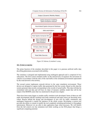
3. SIMULATION
From the global point of view there are two types of simulations: macroscopic and microscopic.
Macroscopic simulations are based on standard macroscopic quantities in the context of transport
sphere, e.g.: traffic flow density, intensity or speed. Particular traffic flows are recognized and
evaluated in this simulation. On the other hand, microscopic simulations consider every entity of
road traffic in detail and all parameters of defined entities and road infrastructure.
As aforementioned before, the aim of simulation in this paper is to generate new traffic data. This
data is generated by individual road participants (vehicles). Data is detected by network of
devices based on different technologies and placed in transport infrastructure. Microscopic
simulation was chosen for its capability to recognize objects at the vehicles level.
An essential step in microsimulation issue is the choice of a suitable traffic model. Paper
published by Wegener [18] provides an interesting summary of the problems traffic models have
had and still have to face. The results of microsimulation have little informative value, because
there are several ways how to solve each traffic problem. Final results then differ, depending on
4. Computer Science & Information Technology (CS & IT)
354
the variant that has been chosen. It is therefore necessary to repeat microsimulation for multiple
variations of model evaluation and then statistically process the results.
The proposed workflow is following:
1.
2.
3.
4.
5.
Creating ontology of interest domain – definition of elements participating in simulation.
Choosing approach under which the simulation will be designed.
Model designing.
Creating the system for road traffic simulation.
Traffic data sources identification, its geographical distribution and data structure.
6. Creating simulation layer of primary traffic data sources.
4. ONTOLOGY
The definition of ontology was formulated in many ways over time - from a philosophical point
of view as the study of nature of being, according to [19] explicit specification of a
conceptualization, according to [20] formal specification of a shared conceptualization or [21]
hierarchically structured set of terms describing a particular substantive area. Various subontologies for different domains are created as artifact reflecting the use of an application or
system.
4.1. Ontology Description
The ontology created for the needs of our simulations is understood as a set of knowledge about
the domain of interest that will be simulated. It is formally described as [22] these six following
sets: O = {C, AC, R, AR, H, F}.
•
•
•
•
•
•
C determines a set of concepts.
AC represents a set of attribute collections (one collection for each concept ci).
R determines a set of relationships. Each relation in R is binary association between two
concepts.
AR represents a set of attribute collections (one collection for each relation ri).
H represents concepts hierarchy.
F specifies constraint on the relations between concept objects or restriction and
constrains on the attribute values of concepts or relationships.
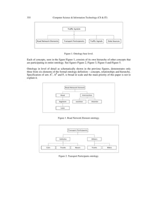
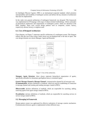
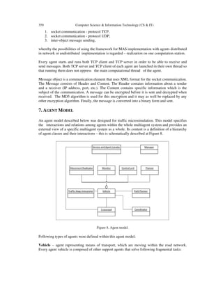
4.2. Traffic Ontology
The main aim when constructing ontology is to capture the knowledge for specific domain. We
have constructed ontology for traffic domain and it was used to design traffic microsimulation.
Base level of our traffic ontology, created to suit the needs of our next work, is composed of these
four concepts: Road Network Elements, Transport Participants, Traffic Signals and Data Sources.
So in this case is set C = {Road Network Elements, Transport Participants, Traffic Signals, Data
Sources}.
5. 355
Computer Science & Information Technology (CS & IT)
Figure 1. Ontology base level.
Each of concepts, seen in the figure Figure 1, consists of its own hierarchy of other concepts that
are participating in entire ontology. See figures Figure 2, Figure 3, Figure 4 and Figure 5.
Ontology in level of detail as schematically shown in the previous figures, demonstrates only
three from six elements of the formal ontology definition – concepts, relationships and hierarchy.
Specification of sets AC, AR and F, is broad in scale and the main priority of this paper is not to
explain it.
Figure 1. Road Network Element ontology.
Figure 2. Transport Participants ontology.
6. Computer Science & Information Technology (CS & IT)
356
Figure 4. Traffic Signals ontology.
Figure 5. Data Sources ontology.
5. PRINCIPLES OF TRAFFIC MICROSIMULATION
In preparation for traffic microsimulation interest domain was surveyed comprehensively.
Existing microsimulation solutions are based on the principles of cellular automata [23-26] neural
networks [27], [28], multi-agent systems [29-33] and various combinations of these approaches
[34].
Multiagent approach for microsimulation modeling was chosen according to the information
gained in the research area and with regard to the intended usage. In general, transportation and
transport systems are a very good example, in which it is appropriate to apply the agent based
approach.
Geographical distribution, changes in characteristics describing alternating peaks and temporary
inactivity are the reasons for solving computational processing of the transport sphere by agent
oriented technology [35], [36].
5.1. Agent Oriented Approach
Road traffic and transport systems are composed of many autonomous entities that show signs of
intelligence. These entities (in the context of transport are represented by vehicles, intersections,
traffic lights, etc.) are deployed in the network and cover a specific part of the area. They interact
with each other in order to meet a common goal.
Agent is a term for a separate entity. Agents possess the ability to perceive their environment, to
communicate with environment and to make independent decisions about their following actions.
7. 357
Computer Science & Information Technology (CS & IT)
Key characteristics of agents are autonomy and integration in environment [37] which they are
able to act autonomously [38].
Multiagent system is a set of agents that represent active components of the modeled system and
are able to interact in order to achieve the general objectives [39].
Transportation problem could be naturally decomposed into sub-units (agents) that interact with
each other in order to achieve the overall goal. To be able to use multiagent modeling approach, it
is necessary for target domain to meet the following three conditions [40]:
• Target domain is geographically distributed.
• The environment, in which subsystems exist, is dynamically changing.
• Flexible mutual interaction is required between subsystems.
Road traffic and transport systems are composed of many autonomous entities that show signs of
intelligence. These entities are deployed in the network and cover a specific part of the area. They
interact with each other in order to meet a common goal. In Agent oriented simulation transport
systems is every single element of intelligent transportation infrastructure modeled through an
agent. Multiagent approach for microsimulation modeling was chosen according to the
information gained in the research area and with regard to the intended usage. In general,
transportation and transport systems are a very good example, in which it is appropriate to apply
the agent based approach.
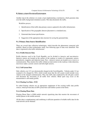
6. MULTIAGENT FRAMEWORK ARCHITECTURE
There are several agent oriented architectures, which are generally used in multiagent modeling.
Each of these architectures is suitable for different task. In our case, the most suitable architecture
is the hierarchical one, in which the hierarchy of agent’s roles is the most essential element.
Central management element is also part of this architecture, but it does not perform all tasks
itself. It may delegate part of the communication and management tasks to the control elements in
lower levels of the hierarchy. Such architecture can be represented in the form of a tree, see
Figure 6. Leaves of the tree represent discrete and finite agents. The advantage of this architecture
is scalability and robustness. Adding additional control elements supports load balancing
management. New element can be simply added as a child of its parent agent and there is no need
to change the implementation of system.
Figure 6. Hierarchical architecture.
In terms of development, deployment and extension of practical applications on multi-agent
principles, it is important to support standards in unified architecture design of multiagent
applications. The solution is implemented and performed according to FIPA standard (Foundation
8. Computer Science & Information Technology (CS & IT)
358
for Intelligent Physical Agents). FIPA is an international respected standard, which promotes
interoperability and reusability of multiagent systems and defines the key elements of architecture
that must be implemented.
In this study own general architecture of multiagent framework was designed. This framework
was implemented in C# language with usage of object-oriented methodology, follows principles
of hierarchical architecture and requirements of multiagent system, which are declared in the
FIPA standard. There were several design patterns such as composite, creator, factory,
respectively abstract factory or singleton used.
6.1. Core of Designed Architecture
Class diagram, see Figure 7, represents specific architecture of a multiagent system. This diagram
reflects only the core of the system. Some classes are not displayed due to the lack of space. The
core design elements are classes Manager, Agent and Structure.
Figure 7. Core of the architecture.
Manager, Agent, Structure: these classes represent hierarchical organization of agents,
specifically utilizable for elementary geofraphical areas in simulated region.
Generic Message Channel a Message Channel: communication channel for all messages sent.
ICommunication: declares definitions of methods, which are used for establishing of connection
to message channel and creating and sending messages (stated in FIFA).
IDiscoverable: declares definitions of methods, which are responsible for searching, adding,
removing agents from agent storage (stated in FIFA).
ILocalisation: declares definitions of methods, which are responsible for searching services in
service storage (stated in FIFA).
5.2. Messaging in Framework
Design pattern creator was applicated for effective realization of message creation mechanism.
Communication between agents is implemented in three different ways:
9. 359
Computer Science & Information Technology (CS & IT)
1. socket communication - protocol TCP,
2. socket communication - protocol UDP,
3. inter-object message sending,
whereby the possibilities of using the framework for MAS implementation with agents distributed
in network or undistributed implementation is regarded – realization on one computation station.
Every agent starts and runs both TCP client and TCP server in order to be able to receive and
send messages. Both TCP server and TCP client of each agent are launched in their own thread so
that running them does not oppress the main computational thread of the agent.
Message object is a communication element that uses XML format for the socket communication.
The Message consists of Header and Content. The Header contains information about a sender
and a receiver (IP address, port, etc.). The Content contains specific information which is the
subject of the communication. A message can be encrypted before it is sent and decrypted when
received. The MD5 algorithm is used for this encryption and it may as well be replaced by any
other encryption algorithm. Finally, the message is converted into a binary form and sent.
7. AGENT MODEL
An agent model described below was designed for traffic microsimulation. This model specifies
the interactions and relations among agents within the whole multiagent system and provides an
external view of a specific multiagent system as a whole. Its content is a definition of a hierarchy
of agent classes and their interactions – this is schematically described at Figure 8.
Figure 8. Agent model.
Following types of agents were defined within this agent model:
Vehicle – agent representing means of transport, which are moving within the road network.
Every agent vehicle is composed of other support agents that solve following fragmental tasks:
10. Computer Science & Information Technology (CS & IT)
•
•
•
•
360
Monitoring of the surroundings and data gathering about other vehicles (agents) – Agent
Monitor.
Data acquisition about traffic communication.
Performing movement, i.e. recalculation of spatial coordinates of its location – Agent
Movement.
Making decisions based on submitted data. Such decisions may be, for example the
manoeuvre of overtaking slow cars, transferring to another lane etc. - Agent Decision
maker.
Crossroad (Intersection) – receives requests of particular vehicle agents for riding through the
crossroad in a given direction. It deals with evaluation of a traffic situation and calculation of the
order in which the cars will ride through the crossroad. The calculation differs according to each
type. There are crossroads with and without traffic lights and these belong among the basic types.
The Crossroad contacts the Vehicle agent as soon as it can ride through the crossroad.
Traffic signs interpreter – the Vehicle agents will call the interpreter with a request to explain
the meaning of traffic signs. Information about traffic signs is contained within the
communication’s geographic data. For example, the interpreter receives a request to explain a
traffic sign, which sets the speed limit to 50 km/h. The answer for the car agent could be: SET
MAX SPEED 50.
Path planner – the vehicle agent is responsible for reading the road segment, where the Vehicle
agent is located. However, it is redundant to map and record the whole journey from the start till
the destination. The agent will keep a list of the closest segments. This list is regularly updated
by the Path planner agent, which is called by the agent every time it passes one of the road
segments.
Service and Agent locator – this agent takes care of connecting to a service and agent database.
The other agents use it to query for a specific agent or service.
Director (manager) – a managing agent for a particular area. Its main task is to manage traffic
fluency. For example, it controls if a crossroad agent is up and running.
Coordinator – this agent takes care of the simulation process by generating car agents and
removing those, who have already participated in the simulation. While creating a vehicle agent a
path, which the agent will follow, must be designed.
8. SIMULATION ENVIRONMENT
The insights of the real world traffic situation are traffic simulations that are realized by the
proposed multiagent framework. This intention is the basis of the idea that the simulation
environment must necessarily be spatial and agents must have the ability of situational
localization.
Multiagent Situated System (MASS) introduces situated agents that are sensitive to their position
and spatial properties, which may restrain or privilege their interactions. Localization of agents
reflects their position and spatial relationships among particular [41].
Geographic data was used to realize the spatial simulation environment. Geographical
information systems normally operate in two-dimensional space, which can be represented as:
11. 361
Computer Science & Information Technology (CS & IT)
• metric,
• topological.
Metric two-dimensional space is used in the cases, when the knowledge of precise absolute
position expressed by coordinates, shape or size is needed. On the other hand, topological space is
mainly used when the expression (or analysis) of mutual spatial relations of objects are needed
[42].
8.1. Object Representation of Environment
Agents connected with the area of transport infrastructure need to perform various computations
over geographic data. While preparing environment for agents, it is necessary to solve the two
following tasks as shown in Figure 9.
1. Prepare geographic data representing selected area of the real world over which the
simulation will be carried out
2. Geographic data is transferred into the simulation environment in the form of object.
Environment in which the multiagent system will be set must represent the road network over
which microsimulation models are implemented. For this purpose analysis of the structure and
content of data was performed on the sample data provided by CEDA (Central European Data
Agency). Attributes that were found unnecessary for the creation of microsimulation were
excluded, which was based on the analysis. Data was purified by its own data pump and its
structure was modified to allow the possibility to design a database over this data according to the
third normal form. An object-relational mapping was performed over this database which resulted
in the object representation of an environment for the agents - the object representation of the
road network.
Figure 9. Simulation environment process.
12. Computer Science & Information Technology (CS & IT)
362
9. SIMULATION SYSTEM EXTENSION
Another step in the solution is to create a layer implementing a mechanism, which generates data
over the traffic background simulation system. This data documents the traffic.
Workflow process:
1. Identification of the traffic data primary sources captured in the traffic infrastructure.
2. Specification of the geographic detector placement is a simulated area.
3. Generated data format specification.
4. Suggestion of the appropriate data structure for saving the generated data.
9.1. Primary Data Source Identification
There are several data collection technologies, which describe the phenomena connected with
mobility. Based on these technologies study, four following types of data were identified. This
data is registered in the traffic infrastructure.
9.1.1. Profile Detector Data
Profile detectors used in the Czech Republic can be divided to intrusive and non-intrusive.
Intrusive sensors are located on the surface of the roadway or inside of it (pneumatic sensors,
piezoelectric, magnetic and induction loops. Non – intrusive sensors are located over or next to a
communication. They monitor the traffic without an intervention in the roadway (video-detection,
microwave radars, acoustic sensors and infra-light sensors).
9.1.2. Toll System Data
Only vehicles over 3,5 t are electronically charged in the Czech Republic. Vehicles under 3,5 are
assumed to be charged by 2016, which would mean that the toll system would include every
vehicle on the charged communication. Thus, the traffic data conducted by the toll gates system
will document the movement of all traffic flow vehicles. Blind spots may occur as the
measurement is still mainly profile.
9.1.3. Floating Car Data – FCD
So called floating vehicles are an appropriate supplement of the existing traffic data profile
sources, which provide data on GPS system basis and Galileo system in the future.
9.1.4. Floating Phone Data
Floating Phone Data is GSM mobile network signalizing data that monitor the movement of
mobile phones in the mobile network.
All this data is complementary and combining it sufficient quantities of reliable traffic data for the
road network can be obtained.
13. 363
Computer Science & Information Technology (CS & IT)
9.2. Artificial Data
Data format of artificially generated data will be inspired by real data format, which is captured
while monitoring transport mobility. This is particularly important in order to process artificially
generated data in the same way as the real data.
Data describing the phenomena associated with the transport mobility have certainly spatiotemporal nature and working with them is not trivial. The design process of optimal data structure
into which the generated data is stored, should not therefore be underestimated, not only because
of their spatio-temporal character, but also because of the volume of data that will directly reflect
the size of the simulated area generated.
9.3. Generating Data Mechanism
Implementation of the extension above the basic traffic simulator tool is also designed using
multiagent approach. Layer for generating the data described in this chapter is separate multiagent
system, which shares the same simulation environment with the original simulator.
The individual data sources are performed by agents that monitor their surroundings, which is
determined by the size and shape of their sensoric field. If there is agent of certain type registered
in the surrounding of monitoring agent, data record is generated.
10. RESULTS
Within a unique project called IT4Innovations, which is a part of international supercomputer
expert workplace site PRACE (Partnership for Advanced Computing in Europe), a supercomputer
center is created in the Czech Republic in the campus of Vysoká škola báňská Technical
University of Ostrava (VŠB-TUO).
In order to increase competitiveness of the Czech Republic in the ITS field a competence center
RODOS was created under the auspices of VSB – TUO or IT4I. Apart from the academic
community, experts in the field of traffic telematics participated on its development. The
Dynamic mobility model is one of the planned outputs of this center. The purpose of this model is
to perform a complex analysis of model that reflects the movement of people and goods based on
actual traffic data. Its outputs will support planning and operational processes within the traffic
system of the Czech Republic.
The use of data collection technologies in the Czech Republic is minor. A current situation of the
area which is not covered by the sensors is not possible to be monitored. In such situation, it is
appropriate to use simulations, which enable us to estimate artificial data with a sufficient
probability. Artificially generated data is adequate to the data actually registered in a traffic
infrastructure, which is the output of the microsimulation model described above. This artificial
data will complement the real data and complete and refine the DMM. See Figure 10.
14. Computer Science & Information Technology (CS & IT)
364
Figure 10. Scheme of simulator’s using.
11. CONCLUSIONS
The prime function of the simulator described in this paper is to generate artificial traffic data
describing phenomena associated with mobility.
The simulator is designed and implemented using multiagent approach and is composed of two
subsystems. The first system simulates traffic on the selected area. It organizes the movement of
vehicles in accordance with the rules of the road traffic in the simulation environment represented
by the road network in the territory.
The second system implements network devices in the same simulation environment. These
devices are designed to capture traffic data generated by the first system. Based on this data the
system generates data records corresponding to the records of actual traffic. This data will then be
assimilated with real data and will have its share of dynamic mobility model that will be the
output of the RODOS centre that was mentioned in the previous chapter.
There have been many bigger or smaller traffic simulator tools developed. Some of them are still
under development and the resulting tools both commercial and open source are becoming more
robust. Reason behind the design and development of new tool for traffic simulations and
multiagent framework is mainly the openness of the whole system. Developing a custom tool
provides the ability to extend or modify the tool completely including performance or throughput
optimization. Moreover we are able to alter application logic when necessary. We will benefit
from the full control over the simulation tool while working on the IT4I project that brings a
significant computing potential.
15. 365
Computer Science & Information Technology (CS & IT)
Tasks to be addressed in the subsequent period includes creation of validation schemas and
validation of simulation system, optimizing storage of generated data with regard to its nature and
spatio-temporal characteristic. Also continuous refining of simulated traffic behaviour.
ACKNOWLEDGEMENTS
This work was supported by the European Regional Development Fund in the IT4Innovations
Centre of Excellence project (CZ.1.05/1.1.00/02.0070) and by Student Grant Competition of
VSB-Technical University of Ostrava, project SP2013/141.
REFERENCES
[1]
[2]
[3]
[4]
[5]
[6]
[7]
[8]
[9]
[10]
[11]
[12]
[13]
[14]
[15]
[16]
[17]
[18]
J. Z. Hernandez, S. Ossowski, A. Garcia-Serrano, “Multiagent architectures for intelligent traffic
management systems”. Transp. Res. Part C: Emerging Technol. October-December 2002, Vol. 10,
5/6, pp. 473-506.
B. C. Da Silva, et al., “ITSUMO: An intelligent transportation system for urban mobility,” Proc.
Innovative Internet Community, Syst. Vol. 3473, pp. 224-235, 2006.
A. Doniec, et al., “A behavioral multi-agent model for road traffic simulation,” Eng. Appl. Artif.
Intell. December 2008, Vol. 21, 8, pp. 1443-1454.
R. Mandiau, et al., “Behaviour based on decision matrices for a coordination between agents in a
urban traffic simulation,” Appl. Intell. April 2008, Vol. 28, 2, pp. 121-138.
M. Vasirani, S. Ossowski, “A market-inspired approach to reservation-based urban road traffic
management,” Proc. 8th Int. Conf. AAMAS, Budapest, Hungaria : s.n., 2009, pp. 617-624.
N. Bhouri, S. Haciane, F. Balbo, “A multi-agent system to regulate urban traffic: Private vehicles and
public transport,” Intelligent Transportation Systems (ITSC),2006, pp. 1575-1581.
B. Smith, W. Scherer, and J. Conklin. “Exploring Imputation Techniques for Missing Data in
Transportation Management Systems.” Transportation Research Record: Journal of Transportation
Research Board 1836, (2003): 132-142.
H. Al-Deek, C. Chandra. “New Algorithms for Filtering and Imputation of Real-Time and Archived
Dual-Loop Detector Data in I–4 Data Warehouse.” Transportation Research Record: Journal of the
Transportation Research Board 1867, (2004): 116-126.
D. Gold, S. Turner, B. Gajewski and C. Spiegelman. “Imputing Missing Values in ITS Data Archives
for Intervals under 5 Minutes,” 80th Annual Meeting of Transportation Research Board, January 7-11,
2001, Washington, D.C.
S. D. Boyles, S. T. Waller, “A Comparison of Interpolation Methods for Missing Traffic Detector
Data,” Transportation Research Board Annual Meeting, 2011.
M. Zhong, S.Sharma, and P. Lingras. “Genetically Designed Models for Accurate Imputation of
Missing Traffi c Counts.” Transportation Research Record: Journal of the Transportation Research
Board 1879, (2004): 71-79.
M. Chen, J. Xia, R. Liu, “Developing a Strategy for Imputing Missing Traffic Volume Data,“ Journal
of the Transportation Research Forum, Vol. 45, No. 3 (2006), pp. 57-75.
Y. Theodoridis, J.R.O. Silva, and M.A. Nascimento. “On the Generation of Spatiotemporal atasets,“
In: Proc. 6th International Symposium on Large Spatial Databases, Hong Kong, China, pp. 147–164,
1999.
D. Pfoser and Y. Theodoridis. “Generating Semantics-Based Trajectories of Moving Objects,“ In:
Proc. International Workshop on Emerging Technologies for Geo-Based Applications, Ascona,
witzerland, pp. 59–76, 2000.
J.-M. Saglio and J. Moreira. Oporto. “A Realistic Scenario Generator for Moving
Objects.,“GeoInformatica 5(1):71–93, March 2001.
T. Tzouramanis, M. Vassilakopoulos, and Y. Manolopoulos. “On the Generation of Time-Evoling
Regional Data,“ GeoInformatica, 6(3):207–231, September 2002.
T. Brinkhoff, “Generating Traffic Data,“ Bulletin of the Technical Committee on Data
Engineerin,IEEE Computer Society, Vol. 26, No. 2, 2003, 19-25.
M. Wegener, “From Macro to Micro - How Much Micro is too Much?,” International Seminar on
Transport Knowledge and Planning Practice, Amsterdam : University of Amsterdam, 2009.
16. Computer Science & Information Technology (CS & IT)
366
[19] T. Gruber, “A Translation Approach to Portable Ontology Specifications,” in: Knowledge
Acquisition, 5(2):199-220, 1993.
[20] W. Borst, Construction of Engineering Ontologies for Knowledge Sharing and Reuse: Ph.D.
Dissertation, University of Twente.
[21] B. Swartout, P. Ramesh , K. Knight , T. Russ, “Toward Distributed Use of Large-Scale Ontologies,”
in Farquhar A, Gruninger M, Gómez-Pérez A, Uschold M, van der Vet P (eds) AAAI'97 Spring
Symposium on Ontological Engineering. Stanford University, California, 1997, pp 138-148.
[22] Tao Feng, Hong Liang, Jianping Wu,“Ontology Driven Data Sharing Between Microscopic Traffic
Simulation and GIS”, IEEE International Conference on Computer Simulation and GIS, Vol. 3, 2010,
pp 84-89.
[23] I. Spyropoulou, „Modelling a signal controlled traffic stream using cellular automata,“ in
Transportation Research Part C: Emerging Technologies, pp. 175-190, 2007.
[24] Y.-S. Han a S.-K. Ko, „Analysis of a cellular automaton model for car traffic with a junction,“
Theoretical Computer Science, 2012.
[25] C. Mallikarjuna and K. Rao, "Identification of a suitable cellular automata model for mixed traffic,"
Journal of East Asian Society for Transportation Studies 7, pp. 2454-2468, 2007.
[26] R. Wang and H. J. Ruskit, "Modelling Traffic Flow at a Multilane Intersection," Computational
Science and Its Applications, 2003.
[27] C. Ledoux, "An Urban Traffic Model Integrating Neural Networks," Transportation Research, vol. 5,
no. 5, pp. 287-300, October 1997.
[28] D. Srinivasan, M. C. Choy and R. L. Cheu, "Neural Networks for Real-Time Traffic Signal Control,"
IEEE Transaction on Intelligent Trasportation Systems, vol. 7, no. 3, pp. 261-272, September 2003.
[29] V.R. Tomas and L. A. Garcia, "Agent-based management of non urban road meteorological
incidents," Proc. Multi-Agent Syst. Appl. IV, pp. 213-222, 2005.
[30] A Donec, R. Mandiau, S. Piechowiak and S. Espie, "A behavioral multi-agent model for road traffic
simulation," Eng. Appl. Artif. Intell., vol. 21, no. 8, pp. 1443-1454, December 2008.
[31] N. Bhouri, S. Haciane and F. Balbo, "A multi-agent system to regulate urban traffic: Private vehicles
and public transport," in Intelligent Transportation Systems (ITSC), 2010.
[32] A Cicortas and N. Somosi, "Multi-Agent System Model for Urban Traffic Simuation," in 2nd
Romanian-Hungarian Joint Symposium on Applied Computational Intelligence, Timisoara, 2005.
[33] D. Meignan, O. Simonin and A. Koukam, "Simulation and evaluation of urban bus-networks using a
multiagent approach," Simul. Model. Pract. Theory, vol. 15, no. 6, pp. 659-671, July 2007.
[34] S. Panwai and H. Dia, "Neural agent car following models," IEEE Transaction on Intelligent
Transportations Systems, vol. 8, no. 1, pp. 60-70, March 2007.
[35] F. Y . Wang, “Agent-based control for networked traffic management”, IEEE Intelligent Systems.
2005, Vol. 20, 5, pp. 92-96.
[36] F. Y. Wang,"Toward a revolution in transportation operations: AI for complex systems," IEEE
Intelligent Systems, vol. 23, no. 6, pp. 8-13, November/December 2008.
[37] A. U.Frank, S. Bittner, M. Raubal, Spatial and Cognitive Simulation with Multi-agent Systems.
COSIT, Vienna, 2001.
[38] M. Wooldridge, “Intelligent Agents,” in: G. Weiss (ed.), Multiagent systems – A modern Approach to
Distributed Artificial Intelligence, MIT Press., Cambridge, MA, 1999. Str. 27-77.
[39] M. Wooldridge, “An Introduction to MultiAgent Systems”, John Wiley & Sons Ltd., Chichester,
2002.
[40] J. L. Adler and V. J. Blue, “A cooperative multi-agent transportation management and route guidance
system,” Transportation Research Part C: Emerging Technologies. 2002, Vol. 10, 5/6, pp. 433-454.
[41] D. Weyns, T. Holvoet.: Model for Simultaneous Actions in Situated Multi-Agent Systems. In Schillo,
M. et al. (eds.): MATES 2003. Springer.Verlag Berlin Heidelberg, 2003. Str. 105-118.
[42] P. Rapant, “Prostor v multiagentových systémech modelujících prostorové procesy,” Acta
Montanistica Slovaca, Košice, Ročník 12(2007), číslo 2, 84-97.
17. 367
Computer Science & Information Technology (CS & IT)
Authors
Ing. Michala DROZDOVA was born in 1987. In 2011, she finished master studies at
VSB-Technical University of Ostrava, Faculty of Electrical Engineering and Computer
Science, Dept. of Computer Science and Engineering. She is currently Ph.D. student. Her
main interests are multi-agents systems, traffic modeling and disaster management.
doc. Ing. Petr RAPANT, CSc. was born in 1960. He is associated professor of
geoinformatics at VSB–Technical University of Ostrava, Czech Republic. His research
area is geoinformatics, spatiotemporal data struc-tures and ontology, and transport
modeling.
Ing. Jan Plucar was born in 1987 in Karvina. In 2011, he finished master studies at VSB-Technical
University of Ostrava. He is currently Ph.D. student. His main interests are bio-inspired computing,
software engineering and software process methodologies.