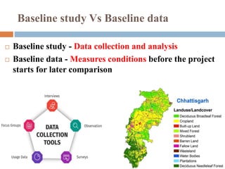
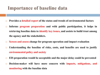
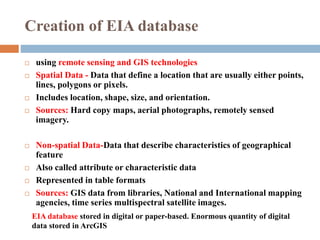
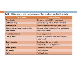
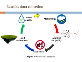
BASELINE STUDY FOR EIA
Jenson Samraj. J
 Baseline study - Data collection and analysis
 Baseline data - Measures conditions before the project
starts for later comparison
Baseline study Vs Baseline data
 Known well before the project gets started
 Should be collected prior and measured in
terms of percent accuracy, duration, time,
frequency, and intervals.
Baseline data
 Existing things such as soil, land, water, and air present in
the environment are known as environmental baselines.
 Kept for reference if an industry fails to control an impact.
Environmental baseline
 Provides a detailed report of the status and trends of environmental factors
 Informs program preparation and with public participation, it helps in
retrieving baseline data to identify key issues, and assists to build trust among
the agency and the stakeholders.
 Screen and assess change for program operation and impact evaluation
 Understanding the baseline of risks, costs, and benefits are used to justify
environmental policy and society
 EIS preparation would be acceptable and the major delay could be prevented
 Decision-maker will have more concern with impacts, mitigations, and
monitoring with the baseline data
Importance of baseline data
 using remote sensing and GIS technologies
 Spatial Data - Data that define a location that are usually either points,
lines, polygons or pixels.
 Includes location, shape, size, and orientation.
 Sources: Hard copy maps, aerial photographs, remotely sensed
imagery.
 Non-spatial Data-Data that describe characteristics of geographical
feature
 Also called attribute or characteristic data
 Represented in table formats
 Sources: GIS data from libraries, National and International mapping
agencies, time series multispectral satellite images.
Creation of EIA database
EIA database stored in digital or paper-based. Enormous quantity of digital
data stored in ArcGIS
Type of data Source of data
Toposheets Survey of India (SOI), Hyderabad
Cadastral maps Central Survey office, Andhra Pradesh
Satellite data National Remote Sensing Center (NRSC)
Village infrastructure and utilities
information
Revenue office, Mandal office, and village
panchayat offices
Forest boundaries Forest Department
Census data Bureau of Economics and Statistics (BES),
Hyderabad
Geologic data Geological Survey of India
Soils National Bureau of Soil Survey
Water quality Laboratory analysis
Air quality Field collection
Noise Field collection
Table. 1 Data source and various types of data products used in EIA study
Baseline data collection
Meteorology
Ambient
air quality
Noise data
Land
environment
Water
quality
Figure. 1 Baseline data collection
Type Locations Parameters Period and
frequency
Ambient Air
Quality
15 locations as
selected during the
baseline study
PM10, PM2.5, Sulfur
dioxide (SO2),
Oxides of nitrogen
(NO2)
24-hr (8hr for CO)
Average samples
every quarter
Ground Water 20 locations as
selected during the
baseline study
pH, TSS, TDS, DO,
BOD
Quarterly
Surface water 20 locations as
selected during the
baseline study
pH, TSS, TDS, DO,
BOD
Quarterly
Noise 15 locations as
selected during the
baseline study
24 hourly day and
Night time Leg level
Quarterly
Soil 20 locations as
selected during the
baseline study
Organic matter, C,
H, N, Alkalinity,
Acidity, heavy
metals
Quarterly
EIA SEA
Prepares document with prescribed format and
contents. The document covers baseline reference for
monitoring
May not be formally documented
Table. 2 Environmental Monitoring Plan for General Construction Works
 Physical: geology, surface, soil types, and groundwater condition,
topography, watershed condition, pollution levels, etc.
 Biological: terrestrial system, flora and fauna, aquatic ecosystems,
environmentally sensitive wetlands, agricultural land, etc
 Socio‐economic: development needs demography, and potential,
economic activities, infrastructure facilities, etc.
 Cultural: site and state of archaeological, antique, spiritual sites
Major environmental parameters
It causes constraints to both developing and developed
countries in the structure and functioning of significant
ecosystems. However, with EIA report with baseline
data could overcome those issues.
What happens if we lack baseline date
1) Title page
2) Acronyms
3) Executive summary
4) Table of contents
5) Introduction and background
6) Methodology (and methodological limitations)
7) Analysis of the findings
8) Conclusions (IFRC, Baseline Basics, 2013).
Writing baseline report
Biswas, A. K., & Pollution Control Research Institute. (1994). Environmental impact assessment for
developing countries: [based on selected papers presented at an International Conference on
Environmental Impact Assessment, held at New Delhi, India, 1991]. Oxford Butterworth-Heinemann.
Depoe, S. P., Delicath, J. W., & Marie-France Aepli Elsenbeer. (2011). Communication and public
participation in environmental decision making. Suny Press; Bristol.
Environmental Impact Assessment. (1983). Dordrecht Springer Netherlands.
Glasson, J., Riki Therivel, & Chadwick, A. (1994). Introduction to environmental impact assessment:
principles and procedures, process, practice, and prospects. Spon Press, [Reprinted.
India: Enhancing Coastal and Ocean Resource Efficiency (ENCORE). (n.d.). World Bank. Retrieved March
19, 2021, from https://www.worldbank.org/en/news/loans-credits/2020/04/28/india-enhancing-
coastal-ocean-resources-efficiency
King, T. F. (2008). ENVIRONMENTAL IMPACT ASSESSMENT AND THE LAW. Encyclopedia of
Archaeology, 1140–1148. https://doi.org/10.1016/b978-012373962-9.00432-5
Organisation for Economic Co-Operation and Development. (2006). Applying Strategic Environmental
Assessment: Good Practice Guidance for Development Co-operation. Oecd Publishing.
Ricci, P. (2006). Environmental and Health Risk Assessment and Management: Principles and Practices. In
www.springer.com. Springer Netherlands.
References

Baseline study for EIA

  • 1.
    BASELINE STUDY FOREIA Jenson Samraj. J
  • 2.
     Baseline study- Data collection and analysis  Baseline data - Measures conditions before the project starts for later comparison Baseline study Vs Baseline data
  • 3.
     Known wellbefore the project gets started  Should be collected prior and measured in terms of percent accuracy, duration, time, frequency, and intervals. Baseline data
  • 4.
     Existing thingssuch as soil, land, water, and air present in the environment are known as environmental baselines.  Kept for reference if an industry fails to control an impact. Environmental baseline
  • 5.
     Provides adetailed report of the status and trends of environmental factors  Informs program preparation and with public participation, it helps in retrieving baseline data to identify key issues, and assists to build trust among the agency and the stakeholders.  Screen and assess change for program operation and impact evaluation  Understanding the baseline of risks, costs, and benefits are used to justify environmental policy and society  EIS preparation would be acceptable and the major delay could be prevented  Decision-maker will have more concern with impacts, mitigations, and monitoring with the baseline data Importance of baseline data
  • 6.
     using remotesensing and GIS technologies  Spatial Data - Data that define a location that are usually either points, lines, polygons or pixels.  Includes location, shape, size, and orientation.  Sources: Hard copy maps, aerial photographs, remotely sensed imagery.  Non-spatial Data-Data that describe characteristics of geographical feature  Also called attribute or characteristic data  Represented in table formats  Sources: GIS data from libraries, National and International mapping agencies, time series multispectral satellite images. Creation of EIA database EIA database stored in digital or paper-based. Enormous quantity of digital data stored in ArcGIS
  • 7.
    Type of dataSource of data Toposheets Survey of India (SOI), Hyderabad Cadastral maps Central Survey office, Andhra Pradesh Satellite data National Remote Sensing Center (NRSC) Village infrastructure and utilities information Revenue office, Mandal office, and village panchayat offices Forest boundaries Forest Department Census data Bureau of Economics and Statistics (BES), Hyderabad Geologic data Geological Survey of India Soils National Bureau of Soil Survey Water quality Laboratory analysis Air quality Field collection Noise Field collection Table. 1 Data source and various types of data products used in EIA study
  • 8.
    Baseline data collection Meteorology Ambient airquality Noise data Land environment Water quality Figure. 1 Baseline data collection
  • 9.
    Type Locations ParametersPeriod and frequency Ambient Air Quality 15 locations as selected during the baseline study PM10, PM2.5, Sulfur dioxide (SO2), Oxides of nitrogen (NO2) 24-hr (8hr for CO) Average samples every quarter Ground Water 20 locations as selected during the baseline study pH, TSS, TDS, DO, BOD Quarterly Surface water 20 locations as selected during the baseline study pH, TSS, TDS, DO, BOD Quarterly Noise 15 locations as selected during the baseline study 24 hourly day and Night time Leg level Quarterly Soil 20 locations as selected during the baseline study Organic matter, C, H, N, Alkalinity, Acidity, heavy metals Quarterly EIA SEA Prepares document with prescribed format and contents. The document covers baseline reference for monitoring May not be formally documented Table. 2 Environmental Monitoring Plan for General Construction Works
  • 10.
     Physical: geology,surface, soil types, and groundwater condition, topography, watershed condition, pollution levels, etc.  Biological: terrestrial system, flora and fauna, aquatic ecosystems, environmentally sensitive wetlands, agricultural land, etc  Socio‐economic: development needs demography, and potential, economic activities, infrastructure facilities, etc.  Cultural: site and state of archaeological, antique, spiritual sites Major environmental parameters
  • 11.
    It causes constraintsto both developing and developed countries in the structure and functioning of significant ecosystems. However, with EIA report with baseline data could overcome those issues. What happens if we lack baseline date
  • 12.
    1) Title page 2)Acronyms 3) Executive summary 4) Table of contents 5) Introduction and background 6) Methodology (and methodological limitations) 7) Analysis of the findings 8) Conclusions (IFRC, Baseline Basics, 2013). Writing baseline report
  • 13.
    Biswas, A. K.,& Pollution Control Research Institute. (1994). Environmental impact assessment for developing countries: [based on selected papers presented at an International Conference on Environmental Impact Assessment, held at New Delhi, India, 1991]. Oxford Butterworth-Heinemann. Depoe, S. P., Delicath, J. W., & Marie-France Aepli Elsenbeer. (2011). Communication and public participation in environmental decision making. Suny Press; Bristol. Environmental Impact Assessment. (1983). Dordrecht Springer Netherlands. Glasson, J., Riki Therivel, & Chadwick, A. (1994). Introduction to environmental impact assessment: principles and procedures, process, practice, and prospects. Spon Press, [Reprinted. India: Enhancing Coastal and Ocean Resource Efficiency (ENCORE). (n.d.). World Bank. Retrieved March 19, 2021, from https://www.worldbank.org/en/news/loans-credits/2020/04/28/india-enhancing- coastal-ocean-resources-efficiency King, T. F. (2008). ENVIRONMENTAL IMPACT ASSESSMENT AND THE LAW. Encyclopedia of Archaeology, 1140–1148. https://doi.org/10.1016/b978-012373962-9.00432-5 Organisation for Economic Co-Operation and Development. (2006). Applying Strategic Environmental Assessment: Good Practice Guidance for Development Co-operation. Oecd Publishing. Ricci, P. (2006). Environmental and Health Risk Assessment and Management: Principles and Practices. In www.springer.com. Springer Netherlands. References