This document outlines a workshop on Python programming in QGIS. It discusses loading and accessing vector and raster layers through Python, modifying layer attributes and geometries, and communicating with users. The workshop covers setting up Python in QGIS, loading layers, iterating over and assessing layers, modifying layers by starting edits and adding features, and visualizing maps on the canvas.
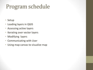


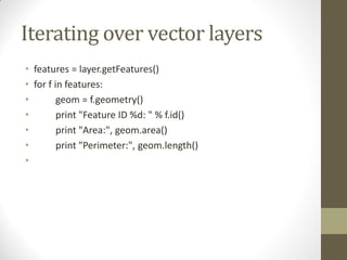
![Geometry construction
• from coordinates
gPnt = QgsGeometry.fromPoint(QgsPoint(1,1))
gLine = QgsGeometry.fromPolyline( [ QgsPoint(1,1), QgsPoint(2,2) ] )
gPolygon = QgsGeometry.fromPolygon( [ [ QgsPoint(1,1), QgsPoint(2,2),
QgsPoint(2,1) ] ] )
Accessor functions are required to extract the information
>>>gPnt.asPoint()
(1,1)
>>> gLine.asPolyline()
[(1,1), (2,2)]
>>> gPolygon.asPolygon()
[[(1,1), (2,2), (2,1), (1,1)]]](https://image.slidesharecdn.com/workshoponpythonqgis-140429045115-phpapp01/85/Workshop-with-python-qgis-14-320.jpg)

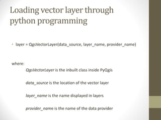
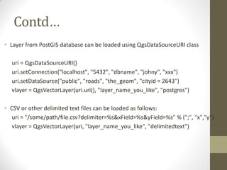
![• # create layer
• vl = QgsVectorLayer("Point", "temporary_points", "memory")
• pr = vl.dataProvider()
• # add fields
• pr.addAttributes( [ QgsField("name", QVariant.String),
• QgsField("age", QVariant.Int),
• QgsField("size", QVariant.Double) ] )
• # add a feature
• fet = QgsFeature()
• fet.setGeometry( QgsGeometry.fromPoint(QgsPoint(10,10)) )
• fet.setAttributes(["Johny", 2, 0.3])
• pr.addFeatures([fet])](https://image.slidesharecdn.com/workshoponpythonqgis-140429045115-phpapp01/85/Workshop-with-python-qgis-17-320.jpg)