Download to read offline


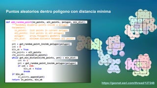
![Agilizar el trabajo con cajas de herramientas
...
if first_point != None:
lst_pnt.append(first_point)
if len(lst_pnt) > 3:
# crear polígono anterior y escribir a fc
polygon = arcpy.Polygon(arcpy.Array(lst_pnt), sr)
curs.insertRow((polygon, nombre, ))
lst_pnt = []
nombre = line.strip()
bln_start = True
arcpy.AddMessage("Procesando polígono: '{0}'".format(nombre))
...](https://image.slidesharecdn.com/b1528360-e8d6-4311-a012-31845e6a8741-150715031654-lva1-app6892/85/Python-en-la-Plataforma-ArcGIS-14-320.jpg)
![Manejar la base de datos centralizada
lst_amb = ["DLLO 9.x", "TEST 9.x", "PROD 9.x", "DLLO 10.x", "TEST 10.x", "PROD 10.x"]
dct_conn = {"DLLO 9.x":r"C:UsersxbakkerAppDataRoamingESRIDesktop10.3ArcCatalogDLLO 9.x.sde",
"TEST 9.x": r"C:UsersxbakkerAppDataRoamingESRIDesktop10.3ArcCatalogTEST 9.x.sde",
"PROD 9.x": r"C:UsersxbakkerAppDataRoamingESRIDesktop10.3ArcCatalogPROD 9.x.sde",
"DLLO 10.x": r"C:UsersxbakkerAppDataRoamingESRIDesktop10.3ArcCatalogDLLO 10.x.sde",
"TEST 10.x": r"C:UsersxbakkerAppDataRoamingESRIDesktop10.3ArcCatalogTEST 10.x.sde",
"PROD 10.x": r"C:UsersxbakkerAppDataRoamingESRIDesktop10.3ArcCatalogPROD 10.x.sde"}
for amb in lst_amb:
arcpy.env.workspace = dct_conn[amb]
lst_ds = arcpy.ListDatasets()
lst_ds.append("")
for ds in lst_ds:
lst_fc = arcpy.ListFeatureClasses(feature_dataset=ds)
for fc in lst_fc:
desc = arcpy.Describe(fc)
feats = int(arcpy.GetCount_management(fc).getOutput(0))
fc_geom = desc.shapeType
sr_name = desc.spatialReference.name
...](https://image.slidesharecdn.com/b1528360-e8d6-4311-a012-31845e6a8741-150715031654-lva1-app6892/85/Python-en-la-Plataforma-ArcGIS-19-320.jpg)
![Analizar el uso de servicios web
with open(logfile, 'r') as f:
for msg in f:
lst_msg = msg.split(' ')
for m in lst_msg:
if ">Extent:" in m:
b = m.replace('>Extent:','')
b = b.replace(';','')
lst_b = b.split(',')
xmin, ymin = lst_b[0], lst_b[1]
xmax, ymax = lst_b[2], lst_b[3]
xcc = (float(xmin) + float(xmax)) / 2.0
ycc = (float(ymin) + float(ymax)) / 2.0
polygon = createPolygonFromExtent(float(xmin), float(ymin),
float(xmax), float(ymax))](https://image.slidesharecdn.com/b1528360-e8d6-4311-a012-31845e6a8741-150715031654-lva1-app6892/85/Python-en-la-Plataforma-ArcGIS-20-320.jpg)
![Analizar el uso de servicios web
dct_geom = {}
dct_oid = {}
cnt = 0
with arcpy.da.SearchCursor(fc_in, ("SHAPE@JSON", "OID@")) as curs:
for row in curs:
cnt += 1
if cnt % 10000 == 0:
print "Leyendo feature: {0}".format(cnt)
txt_json = str(row[0])
oid = row[1]
if txt_json in dct_geom:
dct_geom[txt_json] += 1
else:
dct_geom[txt_json] = 1
dct_oid[txt_json] = oid](https://image.slidesharecdn.com/b1528360-e8d6-4311-a012-31845e6a8741-150715031654-lva1-app6892/85/Python-en-la-Plataforma-ArcGIS-21-320.jpg)
![Analizar el uso de servicios web
# create output fc
path, name = os.path.split(fc_out)
arcpy.CreateFeatureclass_management(path, name, "POLYGON", fc_in, "DISABLED", "DISABLED", sr)
arcpy.AddField_management(fc_out, fldname, "LONG")
with arcpy.da.InsertCursor(fc_out, ("SHAPE@", fldname)) as curs:
cnt = 0
for txt_json, hits in dct_geom.items():
cnt += 1
if cnt % 250 == 0:
print "Processing feature: {0}".format(cnt)
where = "OBJECTID = {0}".format(dct_oid[txt_json])
polygon = arcpy.da.SearchCursor(fc_in, ("SHAPE@",), where).next()[0]
curs.insertRow((polygon, hits,))](https://image.slidesharecdn.com/b1528360-e8d6-4311-a012-31845e6a8741-150715031654-lva1-app6892/85/Python-en-la-Plataforma-ArcGIS-22-320.jpg)
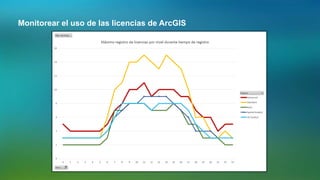
![Monitorear el uso de las licencias de ArcGIS
lmparams='lmstat -f %s -c %i@%s' % (feature, port, server)
stdin,stdout,stderr = os.popen3(lmexe + ' ' + lmparams)
stdout = stdout.read()
stderr = stderr.read()
pattern = re.compile(r'Total of d+ license[s]* avail', re.IGNORECASE)
avail = re.findall(pattern,stdout)
if not avail:
pattern = re.compile(r'Total of d+ license[s]* issued', re.IGNORECASE)
avail = re.findall(pattern,stdout)
if not avail:
raise Exception, '='*10+'nSTDOUT:n'+stdout+'='*10+'nSTDERR:n'+stderr
avail = int(avail[0].split(' ')[2])](https://image.slidesharecdn.com/b1528360-e8d6-4311-a012-31845e6a8741-150715031654-lva1-app6892/85/Python-en-la-Plataforma-ArcGIS-25-320.jpg)


![https://geonet.esri.com/docs/DOC-1927
dct = {r[0]: r[1] for r in arcpy.da.SearchCursor(fc, (fld_oid, fld_valores)) if r[1] > unvalor}](https://image.slidesharecdn.com/b1528360-e8d6-4311-a012-31845e6a8741-150715031654-lva1-app6892/85/Python-en-la-Plataforma-ArcGIS-39-320.jpg)

![Calcular un buffer incluyendo
superficie
https://geonet.esri.com/thread/116656
...
h1 = lst[2]
h_dif = abs(h1-h0)
dist3D = math.sqrt((h_dif**2) + (pixsize**2))
slope = h_dif * 100.0 / pixsize
distcum += dist3D
lst[3] = slope
lst[4] = distcum
dct_vals[val_id] = lst
h0 = h1
if distcum <= max_dist:
dct_res[line_id] = val_id
...](https://image.slidesharecdn.com/b1528360-e8d6-4311-a012-31845e6a8741-150715031654-lva1-app6892/85/Python-en-la-Plataforma-ArcGIS-41-320.jpg)


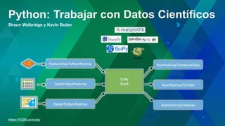


Python is a popular open source programming language that can be used with ArcGIS. It allows users to automate tasks, create custom tools and geoprocessing scripts, and customize their ArcGIS workflow. Python's simplicity, large library of packages, and integration with ArcGIS make it a powerful option for tasks like data analysis, geoprocessing, and managing ArcGIS services and databases. Resources for learning Python and ArcPy include online help, books, tutorials, forums like GeoNet, and training courses from ESRI. Presentations at ESRI Developer Summits have shown examples of using Python for scientific computing and raster analysis tasks.