Weather unit and tools power point #1
•Download as PPT, PDF•
1 like•3,378 views
This PowerPoint goes into details about weather and the tools Scientists use to forecast the weather.
Report
Share
Report
Share

Recommended
Weather instruments ppt for students
This document summarizes various weather instruments used to measure temperature, humidity, wind speed, wind direction, air pressure, rainfall, sunshine, and cloud cover. It describes key features of instruments like thermometers, hygrometers, anemometers, wind vanes, barometers, rain gauges, sunshine recorders, and cloud mirrors. It also discusses the Stevenson screen, which houses other instruments to measure weather elements in a sheltered and shaded environment.
Grade 4 - weather power point
This document summarizes different weather phenomena and tools used to study weather. It describes how temperature, wind, and precipitation are measured using instruments like a thermometer, anemometer, and rain gauge. It also explains different types of clouds, air masses, fronts, storms like hurricanes and tornadoes. Key weather terms are defined, such as humidity, high and low pressure systems, and how meteorologists use barometers and study changes in air pressure to predict weather patterns and conditions.
Weather elements unit 15
This document defines key weather elements and how they are measured. It describes weather as short-term atmospheric conditions while climate refers to long-term averages. Common instruments are discussed like the six's thermometer for temperature inside a Stevenson screen, the rain gauge for rainfall, and the wind vane and wind rose for wind direction and patterns. Formulas are provided for calculating daily, monthly, and annual averages of temperature and rainfall from collected data. Proper siting of instruments is also outlined.
Weather and climate - 4th grade, San Antonio Texas Focus
This document discusses how weather is measured and defined. It explains that weather involves measuring temperature, precipitation, sunshine, air pressure, wind, and cloud cover. Various instruments are used like thermometers, rain gauges, and barometers. Climate is the average weather conditions over time for a region. The document then discusses factors that influence Texas weather like air masses, distance from the equator, and elevation. Climate graphs are introduced which show average monthly rainfall and temperatures on bar and line graphs. An example climate graph is provided for San Antonio.
Weather and climate
This document discusses weather and climate. It defines weather as short-term atmospheric conditions, while climate refers to typical conditions over a long period of time. It describes how temperature, precipitation, wind, and atmospheric pressure are measured. Instruments include a thermometer, rain gauge, anemometer, and barometer. Factors that influence climate are also outlined, such as latitude, proximity to bodies of water, and altitude. Latitude determines climate zones from frigid to temperate to torrid. Bodies of water influence temperature changes, and higher altitudes tend to be colder with more precipitation.
Weather and climate revised dade and duval
This document discusses weather and climate concepts for 5th grade students. It defines weather as the condition of the atmosphere at a particular place and time, noting that weather can change rapidly. It describes how weather is determined by air temperature, barometric pressure, humidity, wind speed and direction, and precipitation. It explains how these factors are measured using tools like thermometers, barometers, hygrometers, wind vanes, and rain gauges. The document also discusses different types of clouds and precipitation and how geographical features can impact climate zones.
Std 7 weather and climate
The document summarizes the key instruments and measurements taken at a weather station. A weather station continuously measures temperature, precipitation, wind, pressure, sunshine, and cloud cover. Standard instruments are used to allow for comparisons between weather stations. Temperature is recorded using thermometers housed in a Stevenson screen, which is painted white, raised above the ground, and has louvred sides. Precipitation, wind direction and speed, pressure, and sunshine are all also measured using common instruments like raingauges, wind vanes, anemometers, barometers, and Campbell-Stokes sunshine recorders. Clouds are observed and types recorded with instruments like nephoscopes.
Unit 4 weather and climate
This document covers key concepts about weather and climate including:
- The difference between weather (short term atmospheric conditions) and climate (long term patterns).
- The factors that cause seasons including the tilt of the Earth and its revolution around the sun.
- How temperature and climate are related, and the different climate zones.
- The factors that affect temperature and precipitation such as latitude, altitude, distance from bodies of water, and humidity levels.
- The different types of rainfall including convective, orographic and frontal.
- How atmospheric pressure influences weather through high and low pressure systems and how pressure relates to wind.
- The main types of winds including prevailing, periodic, synoptic and local
Weather and climate
The document discusses various weather elements and climate concepts. It defines weather as the short-term atmospheric conditions of a place, while climate refers to the average weather conditions over a long period, typically 30 years. It then describes different weather elements such as temperature, rainfall, relative humidity, wind, and cloud cover. It explains how these elements are measured and influenced by various factors like latitude, altitude, distance from the sea, and cloud cover. The document also discusses different climate types including equatorial, monsoon, and cool temperate climates. It examines evidence that the global climate is changing due to natural and human-induced causes such as increasing greenhouse gas emissions.
weather and climate
This document provides information about weather and climate measurements in the UK. It discusses how temperature, precipitation, sunshine, air pressure, wind, and cloud cover are measured. It also explains some key factors that influence Britain's weather, such as its location between 50-60 degrees north, the Gulf Stream, high mountainous areas, and different air masses. Climate graphs are used to show average monthly rainfall and temperatures for different locations.
Weather and climate: basic concepts
This document discusses basic concepts about weather and climate. It defines weather as the current atmospheric conditions in a place, while climate refers to typical weather patterns over a longer period of 30 years. It describes various elements that affect weather and climate, such as temperature, precipitation, atmospheric pressure, winds, and ocean currents. It provides examples of how these elements are measured and influenced by factors like latitude, altitude, and distance from the sea.
Weather and Weather Elements
This document defines key weather-related terms and concepts:
- It describes weather as the condition of the atmosphere in a certain area at a given time. It also discusses meteorology, meteorologists, and the Philippine Atmospheric Geophysical Astronomical Services Administration.
- Key weather elements that are described include air temperature, wind speed and direction, cloud formation, and rainfall. Instruments for measuring these such as thermometers, anemometers, wind vanes, rain gauges, and barometers are also outlined.
- The Beaufort scale for describing wind speed is mentioned, as are terms for describing cloud coverage such as clear, partly cloudy, and overcast.
WEATHER AND CLIMATE
Weather refers to short-term atmospheric conditions like temperature, wind and precipitation in a particular place. Climate describes average weather conditions over a longer period of 30 years for a large area. Meteorologists study weather and climate patterns to predict weather forecasts, which help farmers, pilots and the public prepare for daily and extreme conditions.
Forecasting the weather powerpoint
This document discusses weather forecasting and understanding weather maps. It explains that weather maps show isobars which indicate wind patterns around high and low pressure systems. Closer isobars mean stronger winds. It describes features of high and low pressure systems including wind direction. Cold fronts are shown where cold air pushes warm air upwards, potentially causing rain. Mechanisms that can trigger rain include fronts, low pressure systems, hills and turbulence. Clouds alone do not guarantee rain as clouds need sufficient moisture and lifting of air to produce meaningful rainfall.
My presentation (weather)
This document summarizes key concepts about weather and climate. It defines weather as short-term atmospheric conditions that can change from hour to hour or day to day, while climate refers to average weather conditions over a long period of time. The document then describes different methods for measuring elements of weather like temperature, precipitation, wind speed, cloud cover, sunshine, and air pressure. It provides details on tropical cyclones and their categories based on wind speed. Finally, it outlines the public storm warning signals used in the Philippines.
7 weather, climate and animal adaptations to climate
This document provides information about weather, climate, and how animals adapt to climate. It discusses how weather is measured and reported, and how it varies daily. The maximum and minimum temperatures are recorded each day using special thermometers. Weather describes short-term conditions, while climate refers to average weather patterns over a long period, usually 25 years. The document includes a sample weather report, instructions for an activity to collect weather reports, and tables showing climate data for two cities in India to illustrate differences in climate between places.
Weather And Climate
1. The document discusses weather elements such as temperature, precipitation, wind speed, and cloud cover. It also describes how these elements are measured using instruments like a thermometer, rain gauge, and anemometer.
2. Common types of clouds are described as cirrus, cumulonimbus, cumulus, and stratus. The Stevenson screen, used to shelter instruments, is also characterized.
3. The difference between weather and climate is explained as weather referring to short term atmospheric conditions while climate describes average conditions over a long period.
06 Chapter 11 Weather Climate
This document discusses key concepts about weather and climate, including temperature, rainfall, wind, and how they vary by location. It defines weather as short-term atmospheric conditions and climate as long-term weather patterns. Temperature is influenced by factors like latitude, altitude, and daily cycles. Thermometers are used to measure air temperature in degrees Celsius. Formulas are provided to calculate mean, maximum, minimum, and range of daily, monthly, and annual temperatures.
Weather and Climate
Meteorologists study weather and use weather data to predict conditions. Weather is the current atmospheric conditions of an area, including factors like temperature, wind, and precipitation. Climate is the average weather of a region over a long period of time. Weather instruments and satellites provide accurate weather information that helps meteorologists make forecasts to inform public planning.
Weather and climate updated
This document discusses various weather elements such as temperature, rainfall, relative humidity, air pressure, and wind. It defines these elements and describes the instruments used to measure them. For temperature, it explains how factors such as latitude, altitude, distance from the sea, and cloud cover can influence temperatures in different locations. It also provides examples to illustrate these effects. For rainfall, it distinguishes between convective and relief rainfall and includes diagrams to explain their formation. The document is intended to build understanding of key weather concepts.
Weather and Climate
This document discusses weather and climate concepts including the difference between weather and climate, elements of weather such as temperature, relative humidity, cloud cover, rainfall, air pressure and wind. It also covers factors that affect temperature like latitude, altitude, cloud cover and distance from the sea. Temperature measurements and calculations are defined. Formation of clouds, convectional rain, relief rain, air pressure, winds and land and sea breezes are explained.
Weather & climate 1
This document provides information about weather and climate in Britain. It discusses how weather is measured, including temperature, precipitation, sunshine, wind, air pressure and cloud cover. It then explains some key factors that influence Britain's climate, such as its northern latitude, the Gulf Stream and differences in land elevation. Relief and frontal rainfall, as well as convectional rainfall, are described. The document also covers climate graphs and different air masses that affect Britain.
Weather & climate project by Matthew Ben Hamed 3.02
This document discusses weather and climate. It defines weather as the short-term atmospheric conditions including temperature, precipitation, wind, and cloud cover. Meteorology is the study of these conditions. A variety of instruments are used to measure and forecast weather, including thermometers, rain gauges, wind vanes, and cloud classification scales. Microclimates within small areas can differ due to physical features, shelter, surface types, and aspect. The water cycle and different types of rainfall like frontal, relief, and convectional rainfall are also explained. High and low pressure systems like anticyclones and depressions impact weather patterns.
Unit 1 weather and climate s.s 4
The document discusses weather and climate concepts including:
- The five layers of the atmosphere and what comprises the atmosphere.
- The three factors that characterize weather: air temperature, water vapor, and wind.
- What weather stations measure including temperature, wind speed, precipitation, and direction.
- The four seasons and what causes them, which is how the sun's rays reach Earth's surface.
- What climate is, which is the typical weather over a long period of time characterized by temperature and precipitation.
- The three main climate zones: polar, temperate, and tropical.
Weather
This document describes various instruments used to measure different weather elements. It discusses rain gauges to measure rainfall, wet and dry bulb thermometers and hair hygrometers to measure relative humidity, sunshine recorders to measure sunlight duration, luxmeters to measure light intensity, Stevenson's screens and maximum/minimum thermometers to measure air temperature, barometers to measure air pressure, anemometers and wind vanes to measure wind speed and direction, evaporimeters to measure evapotranspiration, radar to detect precipitation, and radiosondes carried by weather balloons to measure temperature, humidity and pressure at different altitudes.
Weather & climate
This document discusses weather and climate concepts. It defines weather as short-term atmospheric conditions while climate describes average weather patterns over long periods of time. It describes elements that influence climate such as temperature, wind, precipitation and atmospheric pressure. Specific climate zones are also outlined including equatorial, tropical, temperate, mountain and polar zones. Climate zones within Spain are identified as well.
4E Weather & Climate
This document discusses weather and climate elements such as temperature, relative humidity, clouds, and factors that affect them. It defines weather as short-term atmospheric conditions while climate refers to average conditions over 30 years. Temperature is influenced by latitude, altitude, cloud cover, and distance from the sea. Relative humidity depends on the amount of water vapor in the air and temperature. Clouds form through the process of evaporation and condensation as water vapor rises and cools in the atmosphere.
Weather And Climate
The document provides an overview of weather and climate concepts. It discusses the water cycle, factors that affect weather like the sun, atmosphere, oceans, and how weather occurs in the troposphere. It also defines climate as the long-term patterns over large areas, and describes the three main climate zones: polar, temperate, and tropical. Storms like thunderstorms, hurricanes, and tornadoes are also summarized.
Weather and climate
The document provides information about weather forecasting and the key elements of weather and climate. It discusses:
- Temperature is a measure of heat intensity and is affected by factors like latitude, altitude, distance from the sea, winds, and ocean currents.
- Atmospheric pressure is the pressure exerted by the weight of the atmosphere and is highest at sea level, decreasing with altitude. It is influenced by temperature, moisture, Earth's rotation, and affects wind patterns.
- Different types of winds include planetary winds like trade winds and westerlies, periodic winds, and local winds that vary by region. Wind is measured by direction and speed.
- Humidity refers to the amount of water vapor in
Climate
Climate refers to the average weather conditions in an area over a long period of time. There are three main climate zones: tropical, polar, and temperate. Factors that affect climate include temperature, latitude, altitude, proximity to bodies of water, wind patterns, and amount of rainfall. The document then describes various wind systems and seasonal patterns around the world. Climate study is called meteorology, while weather describes short term conditions. People's activities can impact climate change through carbon dioxide emissions.
More Related Content
What's hot
Weather and climate
The document discusses various weather elements and climate concepts. It defines weather as the short-term atmospheric conditions of a place, while climate refers to the average weather conditions over a long period, typically 30 years. It then describes different weather elements such as temperature, rainfall, relative humidity, wind, and cloud cover. It explains how these elements are measured and influenced by various factors like latitude, altitude, distance from the sea, and cloud cover. The document also discusses different climate types including equatorial, monsoon, and cool temperate climates. It examines evidence that the global climate is changing due to natural and human-induced causes such as increasing greenhouse gas emissions.
weather and climate
This document provides information about weather and climate measurements in the UK. It discusses how temperature, precipitation, sunshine, air pressure, wind, and cloud cover are measured. It also explains some key factors that influence Britain's weather, such as its location between 50-60 degrees north, the Gulf Stream, high mountainous areas, and different air masses. Climate graphs are used to show average monthly rainfall and temperatures for different locations.
Weather and climate: basic concepts
This document discusses basic concepts about weather and climate. It defines weather as the current atmospheric conditions in a place, while climate refers to typical weather patterns over a longer period of 30 years. It describes various elements that affect weather and climate, such as temperature, precipitation, atmospheric pressure, winds, and ocean currents. It provides examples of how these elements are measured and influenced by factors like latitude, altitude, and distance from the sea.
Weather and Weather Elements
This document defines key weather-related terms and concepts:
- It describes weather as the condition of the atmosphere in a certain area at a given time. It also discusses meteorology, meteorologists, and the Philippine Atmospheric Geophysical Astronomical Services Administration.
- Key weather elements that are described include air temperature, wind speed and direction, cloud formation, and rainfall. Instruments for measuring these such as thermometers, anemometers, wind vanes, rain gauges, and barometers are also outlined.
- The Beaufort scale for describing wind speed is mentioned, as are terms for describing cloud coverage such as clear, partly cloudy, and overcast.
WEATHER AND CLIMATE
Weather refers to short-term atmospheric conditions like temperature, wind and precipitation in a particular place. Climate describes average weather conditions over a longer period of 30 years for a large area. Meteorologists study weather and climate patterns to predict weather forecasts, which help farmers, pilots and the public prepare for daily and extreme conditions.
Forecasting the weather powerpoint
This document discusses weather forecasting and understanding weather maps. It explains that weather maps show isobars which indicate wind patterns around high and low pressure systems. Closer isobars mean stronger winds. It describes features of high and low pressure systems including wind direction. Cold fronts are shown where cold air pushes warm air upwards, potentially causing rain. Mechanisms that can trigger rain include fronts, low pressure systems, hills and turbulence. Clouds alone do not guarantee rain as clouds need sufficient moisture and lifting of air to produce meaningful rainfall.
My presentation (weather)
This document summarizes key concepts about weather and climate. It defines weather as short-term atmospheric conditions that can change from hour to hour or day to day, while climate refers to average weather conditions over a long period of time. The document then describes different methods for measuring elements of weather like temperature, precipitation, wind speed, cloud cover, sunshine, and air pressure. It provides details on tropical cyclones and their categories based on wind speed. Finally, it outlines the public storm warning signals used in the Philippines.
7 weather, climate and animal adaptations to climate
This document provides information about weather, climate, and how animals adapt to climate. It discusses how weather is measured and reported, and how it varies daily. The maximum and minimum temperatures are recorded each day using special thermometers. Weather describes short-term conditions, while climate refers to average weather patterns over a long period, usually 25 years. The document includes a sample weather report, instructions for an activity to collect weather reports, and tables showing climate data for two cities in India to illustrate differences in climate between places.
Weather And Climate
1. The document discusses weather elements such as temperature, precipitation, wind speed, and cloud cover. It also describes how these elements are measured using instruments like a thermometer, rain gauge, and anemometer.
2. Common types of clouds are described as cirrus, cumulonimbus, cumulus, and stratus. The Stevenson screen, used to shelter instruments, is also characterized.
3. The difference between weather and climate is explained as weather referring to short term atmospheric conditions while climate describes average conditions over a long period.
06 Chapter 11 Weather Climate
This document discusses key concepts about weather and climate, including temperature, rainfall, wind, and how they vary by location. It defines weather as short-term atmospheric conditions and climate as long-term weather patterns. Temperature is influenced by factors like latitude, altitude, and daily cycles. Thermometers are used to measure air temperature in degrees Celsius. Formulas are provided to calculate mean, maximum, minimum, and range of daily, monthly, and annual temperatures.
Weather and Climate
Meteorologists study weather and use weather data to predict conditions. Weather is the current atmospheric conditions of an area, including factors like temperature, wind, and precipitation. Climate is the average weather of a region over a long period of time. Weather instruments and satellites provide accurate weather information that helps meteorologists make forecasts to inform public planning.
Weather and climate updated
This document discusses various weather elements such as temperature, rainfall, relative humidity, air pressure, and wind. It defines these elements and describes the instruments used to measure them. For temperature, it explains how factors such as latitude, altitude, distance from the sea, and cloud cover can influence temperatures in different locations. It also provides examples to illustrate these effects. For rainfall, it distinguishes between convective and relief rainfall and includes diagrams to explain their formation. The document is intended to build understanding of key weather concepts.
Weather and Climate
This document discusses weather and climate concepts including the difference between weather and climate, elements of weather such as temperature, relative humidity, cloud cover, rainfall, air pressure and wind. It also covers factors that affect temperature like latitude, altitude, cloud cover and distance from the sea. Temperature measurements and calculations are defined. Formation of clouds, convectional rain, relief rain, air pressure, winds and land and sea breezes are explained.
Weather & climate 1
This document provides information about weather and climate in Britain. It discusses how weather is measured, including temperature, precipitation, sunshine, wind, air pressure and cloud cover. It then explains some key factors that influence Britain's climate, such as its northern latitude, the Gulf Stream and differences in land elevation. Relief and frontal rainfall, as well as convectional rainfall, are described. The document also covers climate graphs and different air masses that affect Britain.
Weather & climate project by Matthew Ben Hamed 3.02
This document discusses weather and climate. It defines weather as the short-term atmospheric conditions including temperature, precipitation, wind, and cloud cover. Meteorology is the study of these conditions. A variety of instruments are used to measure and forecast weather, including thermometers, rain gauges, wind vanes, and cloud classification scales. Microclimates within small areas can differ due to physical features, shelter, surface types, and aspect. The water cycle and different types of rainfall like frontal, relief, and convectional rainfall are also explained. High and low pressure systems like anticyclones and depressions impact weather patterns.
Unit 1 weather and climate s.s 4
The document discusses weather and climate concepts including:
- The five layers of the atmosphere and what comprises the atmosphere.
- The three factors that characterize weather: air temperature, water vapor, and wind.
- What weather stations measure including temperature, wind speed, precipitation, and direction.
- The four seasons and what causes them, which is how the sun's rays reach Earth's surface.
- What climate is, which is the typical weather over a long period of time characterized by temperature and precipitation.
- The three main climate zones: polar, temperate, and tropical.
Weather
This document describes various instruments used to measure different weather elements. It discusses rain gauges to measure rainfall, wet and dry bulb thermometers and hair hygrometers to measure relative humidity, sunshine recorders to measure sunlight duration, luxmeters to measure light intensity, Stevenson's screens and maximum/minimum thermometers to measure air temperature, barometers to measure air pressure, anemometers and wind vanes to measure wind speed and direction, evaporimeters to measure evapotranspiration, radar to detect precipitation, and radiosondes carried by weather balloons to measure temperature, humidity and pressure at different altitudes.
Weather & climate
This document discusses weather and climate concepts. It defines weather as short-term atmospheric conditions while climate describes average weather patterns over long periods of time. It describes elements that influence climate such as temperature, wind, precipitation and atmospheric pressure. Specific climate zones are also outlined including equatorial, tropical, temperate, mountain and polar zones. Climate zones within Spain are identified as well.
4E Weather & Climate
This document discusses weather and climate elements such as temperature, relative humidity, clouds, and factors that affect them. It defines weather as short-term atmospheric conditions while climate refers to average conditions over 30 years. Temperature is influenced by latitude, altitude, cloud cover, and distance from the sea. Relative humidity depends on the amount of water vapor in the air and temperature. Clouds form through the process of evaporation and condensation as water vapor rises and cools in the atmosphere.
Weather And Climate
The document provides an overview of weather and climate concepts. It discusses the water cycle, factors that affect weather like the sun, atmosphere, oceans, and how weather occurs in the troposphere. It also defines climate as the long-term patterns over large areas, and describes the three main climate zones: polar, temperate, and tropical. Storms like thunderstorms, hurricanes, and tornadoes are also summarized.
What's hot (20)
7 weather, climate and animal adaptations to climate
7 weather, climate and animal adaptations to climate
Weather & climate project by Matthew Ben Hamed 3.02
Weather & climate project by Matthew Ben Hamed 3.02
Similar to Weather unit and tools power point #1
Weather and climate
The document provides information about weather forecasting and the key elements of weather and climate. It discusses:
- Temperature is a measure of heat intensity and is affected by factors like latitude, altitude, distance from the sea, winds, and ocean currents.
- Atmospheric pressure is the pressure exerted by the weight of the atmosphere and is highest at sea level, decreasing with altitude. It is influenced by temperature, moisture, Earth's rotation, and affects wind patterns.
- Different types of winds include planetary winds like trade winds and westerlies, periodic winds, and local winds that vary by region. Wind is measured by direction and speed.
- Humidity refers to the amount of water vapor in
Climate
Climate refers to the average weather conditions in an area over a long period of time. There are three main climate zones: tropical, polar, and temperate. Factors that affect climate include temperature, latitude, altitude, proximity to bodies of water, wind patterns, and amount of rainfall. The document then describes various wind systems and seasonal patterns around the world. Climate study is called meteorology, while weather describes short term conditions. People's activities can impact climate change through carbon dioxide emissions.
Air masses and fronts
Air masses are large bodies of air that maintain consistent temperatures and moisture levels as they move across regions. They are classified by their source location and surface, resulting in four main types: continental polar, continental tropical, maritime polar, and maritime tropical. When two air masses meet, fronts form along the boundary which can cause precipitation. The main front types are warm, cold, stationary, and occluded fronts, which differ based on the advancing air mass temperature and resulting weather impacts.
science4q4w4-Weather instruments.pptx
Meteorologists use various instruments to measure weather conditions and make predictions. Thermometers measure air temperature, barometers measure air pressure, anemometers measure wind speed and direction, hygrometers measure temperature and humidity, rain gauges measure precipitation, wind vanes measure wind direction, and Campbell Stokes recorders measure sunshine. Weather charts are created using data from these instruments to analyze current conditions and forecast future weather.
Weather
Weather describes short-term atmospheric conditions like temperature, humidity, wind and precipitation that can be measured using instruments like thermometers, barometers, hygrometers, anemometers and pluviometers. Climate is defined by long-term weather patterns over many years that are influenced by a region's latitude, altitude, proximity to oceans, and terrain features which impact temperature fluctuations, rainfall amounts and cloud formation.
Weather
Weather describes short-term atmospheric conditions like temperature, humidity, wind and precipitation that can be measured using instruments like thermometers, barometers, hygrometers, anemometers and pluviometers. Climate is defined by long-term weather patterns over many years that are influenced by a region's latitude, altitude, proximity to oceans, and terrain features which impact temperature fluctuations, rainfall amounts, and cloud and wind formation.
Weather and climate nico
Weather refers to atmospheric conditions at a specific moment, while climate refers to conditions over a long period of time. Key factors that influence climate include latitude, distance from bodies of water, and altitude. The document then describes the main climate zones on Earth - hot zones near the equator; temperate zones with milder temperatures; and cold zones at high altitudes and polar regions. It concludes by noting that climate change is caused by increasing global temperatures and will result in rising sea levels, more extreme weather, drought in some areas, and increased risk of species extinction.
The atmosphere
The document defines the key components of Earth's atmosphere, including nitrogen, oxygen, carbon dioxide and other gases. It also discusses water vapor, aerosols, and ozone within the atmosphere. Additionally, it defines important atmospheric elements such as temperature, humidity, wind, precipitation and air pressure. It provides details on how each of these elements are measured and how they interact with one another and impact the weather and climate.
Chapter 17 7th es
This document discusses air masses and weather systems. It defines air masses as large bodies of air classified by temperature and moisture content. As air masses move away from their source regions, their temperature and humidity change. The document describes the four main types of air masses - maritime tropical, maritime polar, continental polar, and continental tropical - and the weather typically associated with each. It also discusses fronts, where different air masses meet; cyclones and anticyclones; thunderstorms and tornadoes; hurricanes; and lake-effect snow. Meteorologists use tools like weather balloons, satellites, and computer models to analyze weather data and improve forecasting.
Weather
This document discusses weather and the elements that define it. It describes the four seasons and how the Earth's movement around the sun creates them. It also outlines instruments used to measure temperature, precipitation, wind speed and direction. Questions are provided to test comprehension, and activities are suggested to have students order atmospheric layers, report current weather, name measuring tools and identify the current season.
World climates
World climates are influenced by four main factors: latitude, altitude, proximity to oceans, and ocean currents. There are five main climate zones - tropical, dry, temperate, continental, and polar. Within each zone are different climate types that influence the native biomes and human activities in those regions. For example, equatorial climates near the equator have rainforests, while grasslands are found in areas with dry midlatitude climates that have warm summers and cold winters. Human activities also vary depending on the climate, such as burning rainforests for agriculture in tropical regions or growing vineyards along temperate west coasts.
9.3 weather
The document discusses weather and defines it as the atmospheric conditions at a given time and place. It describes the components that make up weather, including temperature, wind, precipitation, and different types of clouds. It also explains several types of severe weather such as thunderstorms, floods, droughts, blizzards, hurricanes, heat waves, and ice storms, providing details on their characteristic precipitation, temperature, and wind conditions. Weather instruments are used to gather data and help predict upcoming weather patterns.
Chapter 11 Weather and Climate lesson slides published
Dear 2C and 2G,
Attached are the lesson slides for Chapter 11 on Weather and Climate.
The Earth is fragile, everyone plays a part!
Mr Tan
Weather maps and their symbols
The document discusses weather maps and how they are used to predict weather conditions. It provides information on several key topics:
- The atmosphere helps regulate Earth's temperature and creates weather through the movement of air masses. Weather maps show current conditions.
- Weather is influenced by properties like temperature, humidity and pressure. Maps depict systems like cold fronts, warm fronts and stationary fronts to understand weather changes.
- High and low pressure areas circulate clockwise and counterclockwise respectively, affecting wind patterns and whether conditions will be clear or stormy. Weather maps are interpreted to forecast upcoming weather.
Weather
Weather is influenced by temperature, humidity, and air pressure. It describes the current condition of the atmosphere like sunny, windy, or rainy. Climate refers to the general weather conditions of an area, like the tropical climate in the Bahamas. Meteorologists study weather and how factors like changes in air pressure cause weather to change. Air pressure is caused by the weight of air in the atmosphere and can be measured with a barometer.
weather and climate ppt.pptx
Weather refers to short term atmospheric conditions while climate describes long term weather patterns of a location. The study of weather is called meteorology, while the study of climate is called climatology. Various elements that determine weather include temperature, sunshine, precipitation, atmospheric pressure, winds, humidity and clouds. These elements are influenced by factors like latitude, altitude, distance from oceans, wind direction and ocean currents. Instruments like thermometers, barometers, hygrometers, and anemometers are used to measure and record these weather elements.
Meteorological environment
This document discusses key elements of meteorology and the meteorological environment. It describes atmospheric pressure, air temperature, humidity, rainfall, wind speed and direction, and cloud movement/weather. It covers instruments used to measure these elements like barometers, thermometers, hygrometers, and rain gauges. It also discusses effects of exposure to high and low altitudes/pressures on humans.
Factors that affect climate 4
This document discusses various factors that affect climate, including latitude, altitude, distance to large bodies of water, ocean currents, prevailing winds, and topography. It provides examples of how each factor influences climate and temperature patterns. For instance, coastal areas tend to have more moderate temperatures due to the ocean's moderating effect, while inland locations experience more temperature fluctuations. Higher altitudes also generally have cooler temperatures. The document emphasizes that climate considers long-term weather trends over many years, as opposed to short-term weather conditions.
7th Grade - Chapter 5 - Weather
This document provides an overview of weather and weather patterns. It defines weather as the conditions of the atmosphere at a specific time and place, describing factors such as temperature, wind, humidity and precipitation. It describes how the sun provides energy and uneven heating leads to changes in air pressure and wind. It explains cloud formation and types of precipitation. The document also discusses air masses and how high and low pressure systems influence weather patterns through cyclonic and anticyclonic wind flow.
Alarming Typhoons
This document discusses typhoons and weather. It defines typhoons, cyclones, and hurricanes as intense low pressure weather systems that form over warm ocean waters. Typhoons develop in stages through evaporation of water, rising warm air, condensation of water vapor to form clouds, and faster rotating winds due to the Coriolis effect. The key conditions for typhoon formation are continuous evaporation and water cycles, differences in air pressure, and convergent winds blowing toward a central area. Meteorologists use various instruments like anemometers, barometers, thermometers, and wind vanes to monitor weather conditions.
Similar to Weather unit and tools power point #1 (20)
Chapter 11 Weather and Climate lesson slides published
Chapter 11 Weather and Climate lesson slides published
Recently uploaded
DevOps and Testing slides at DASA Connect
My and Rik Marselis slides at 30.5.2024 DASA Connect conference. We discuss about what is testing, then what is agile testing and finally what is Testing in DevOps. Finally we had lovely workshop with the participants trying to find out different ways to think about quality and testing in different parts of the DevOps infinity loop.
GridMate - End to end testing is a critical piece to ensure quality and avoid...
End to end testing is a critical piece to ensure quality and avoid regressions. In this session, we share our journey building an E2E testing pipeline for GridMate components (LWC and Aura) using Cypress, JSForce, FakerJS…
GraphSummit Singapore | Neo4j Product Vision & Roadmap - Q2 2024
Maruthi Prithivirajan, Head of ASEAN & IN Solution Architecture, Neo4j
Get an inside look at the latest Neo4j innovations that enable relationship-driven intelligence at scale. Learn more about the newest cloud integrations and product enhancements that make Neo4j an essential choice for developers building apps with interconnected data and generative AI.
GraphSummit Singapore | The Art of the Possible with Graph - Q2 2024
Neha Bajwa, Vice President of Product Marketing, Neo4j
Join us as we explore breakthrough innovations enabled by interconnected data and AI. Discover firsthand how organizations use relationships in data to uncover contextual insights and solve our most pressing challenges – from optimizing supply chains, detecting fraud, and improving customer experiences to accelerating drug discoveries.
Artificial Intelligence for XMLDevelopment
In the rapidly evolving landscape of technologies, XML continues to play a vital role in structuring, storing, and transporting data across diverse systems. The recent advancements in artificial intelligence (AI) present new methodologies for enhancing XML development workflows, introducing efficiency, automation, and intelligent capabilities. This presentation will outline the scope and perspective of utilizing AI in XML development. The potential benefits and the possible pitfalls will be highlighted, providing a balanced view of the subject.
We will explore the capabilities of AI in understanding XML markup languages and autonomously creating structured XML content. Additionally, we will examine the capacity of AI to enrich plain text with appropriate XML markup. Practical examples and methodological guidelines will be provided to elucidate how AI can be effectively prompted to interpret and generate accurate XML markup.
Further emphasis will be placed on the role of AI in developing XSLT, or schemas such as XSD and Schematron. We will address the techniques and strategies adopted to create prompts for generating code, explaining code, or refactoring the code, and the results achieved.
The discussion will extend to how AI can be used to transform XML content. In particular, the focus will be on the use of AI XPath extension functions in XSLT, Schematron, Schematron Quick Fixes, or for XML content refactoring.
The presentation aims to deliver a comprehensive overview of AI usage in XML development, providing attendees with the necessary knowledge to make informed decisions. Whether you’re at the early stages of adopting AI or considering integrating it in advanced XML development, this presentation will cover all levels of expertise.
By highlighting the potential advantages and challenges of integrating AI with XML development tools and languages, the presentation seeks to inspire thoughtful conversation around the future of XML development. We’ll not only delve into the technical aspects of AI-powered XML development but also discuss practical implications and possible future directions.
National Security Agency - NSA mobile device best practices
Threats to mobile devices are more prevalent and increasing in scope and complexity. Users of mobile devices desire to take full advantage of the features
available on those devices, but many of the features provide convenience and capability but sacrifice security. This best practices guide outlines steps the users can take to better protect personal devices and information.
Uni Systems Copilot event_05062024_C.Vlachos.pdf
Unlocking Productivity: Leveraging the Potential of Copilot in Microsoft 365, a presentation by Christoforos Vlachos, Senior Solutions Manager – Modern Workplace, Uni Systems
Mind map of terminologies used in context of Generative AI
Mind map of common terms used in context of Generative AI.
GDG Cloud Southlake #33: Boule & Rebala: Effective AppSec in SDLC using Deplo...
Effective Application Security in Software Delivery lifecycle using Deployment Firewall and DBOM
The modern software delivery process (or the CI/CD process) includes many tools, distributed teams, open-source code, and cloud platforms. Constant focus on speed to release software to market, along with the traditional slow and manual security checks has caused gaps in continuous security as an important piece in the software supply chain. Today organizations feel more susceptible to external and internal cyber threats due to the vast attack surface in their applications supply chain and the lack of end-to-end governance and risk management.
The software team must secure its software delivery process to avoid vulnerability and security breaches. This needs to be achieved with existing tool chains and without extensive rework of the delivery processes. This talk will present strategies and techniques for providing visibility into the true risk of the existing vulnerabilities, preventing the introduction of security issues in the software, resolving vulnerabilities in production environments quickly, and capturing the deployment bill of materials (DBOM).
Speakers:
Bob Boule
Robert Boule is a technology enthusiast with PASSION for technology and making things work along with a knack for helping others understand how things work. He comes with around 20 years of solution engineering experience in application security, software continuous delivery, and SaaS platforms. He is known for his dynamic presentations in CI/CD and application security integrated in software delivery lifecycle.
Gopinath Rebala
Gopinath Rebala is the CTO of OpsMx, where he has overall responsibility for the machine learning and data processing architectures for Secure Software Delivery. Gopi also has a strong connection with our customers, leading design and architecture for strategic implementations. Gopi is a frequent speaker and well-known leader in continuous delivery and integrating security into software delivery.
How to Get CNIC Information System with Paksim Ga.pptx
Pakdata Cf is a groundbreaking system designed to streamline and facilitate access to CNIC information. This innovative platform leverages advanced technology to provide users with efficient and secure access to their CNIC details.
GraphSummit Singapore | Graphing Success: Revolutionising Organisational Stru...
Sudheer Mechineni, Head of Application Frameworks, Standard Chartered Bank
Discover how Standard Chartered Bank harnessed the power of Neo4j to transform complex data access challenges into a dynamic, scalable graph database solution. This keynote will cover their journey from initial adoption to deploying a fully automated, enterprise-grade causal cluster, highlighting key strategies for modelling organisational changes and ensuring robust disaster recovery. Learn how these innovations have not only enhanced Standard Chartered Bank’s data infrastructure but also positioned them as pioneers in the banking sector’s adoption of graph technology.
Removing Uninteresting Bytes in Software Fuzzing
Imagine a world where software fuzzing, the process of mutating bytes in test seeds to uncover hidden and erroneous program behaviors, becomes faster and more effective. A lot depends on the initial seeds, which can significantly dictate the trajectory of a fuzzing campaign, particularly in terms of how long it takes to uncover interesting behaviour in your code. We introduce DIAR, a technique designed to speedup fuzzing campaigns by pinpointing and eliminating those uninteresting bytes in the seeds. Picture this: instead of wasting valuable resources on meaningless mutations in large, bloated seeds, DIAR removes the unnecessary bytes, streamlining the entire process.
In this work, we equipped AFL, a popular fuzzer, with DIAR and examined two critical Linux libraries -- Libxml's xmllint, a tool for parsing xml documents, and Binutil's readelf, an essential debugging and security analysis command-line tool used to display detailed information about ELF (Executable and Linkable Format). Our preliminary results show that AFL+DIAR does not only discover new paths more quickly but also achieves higher coverage overall. This work thus showcases how starting with lean and optimized seeds can lead to faster, more comprehensive fuzzing campaigns -- and DIAR helps you find such seeds.
- These are slides of the talk given at IEEE International Conference on Software Testing Verification and Validation Workshop, ICSTW 2022.
Full-RAG: A modern architecture for hyper-personalization
Mike Del Balso, CEO & Co-Founder at Tecton, presents "Full RAG," a novel approach to AI recommendation systems, aiming to push beyond the limitations of traditional models through a deep integration of contextual insights and real-time data, leveraging the Retrieval-Augmented Generation architecture. This talk will outline Full RAG's potential to significantly enhance personalization, address engineering challenges such as data management and model training, and introduce data enrichment with reranking as a key solution. Attendees will gain crucial insights into the importance of hyperpersonalization in AI, the capabilities of Full RAG for advanced personalization, and strategies for managing complex data integrations for deploying cutting-edge AI solutions.
みなさんこんにちはこれ何文字まで入るの?40文字以下不可とか本当に意味わからないけどこれ限界文字数書いてないからマジでやばい文字数いけるんじゃないの?えこ...
ここ3000字までしか入らないけどタイトルの方がたくさん文字入ると思います。
Communications Mining Series - Zero to Hero - Session 1
This session provides introduction to UiPath Communication Mining, importance and platform overview. You will acquire a good understand of the phases in Communication Mining as we go over the platform with you. Topics covered:
• Communication Mining Overview
• Why is it important?
• How can it help today’s business and the benefits
• Phases in Communication Mining
• Demo on Platform overview
• Q/A
Essentials of Automations: The Art of Triggers and Actions in FME
In this second installment of our Essentials of Automations webinar series, we’ll explore the landscape of triggers and actions, guiding you through the nuances of authoring and adapting workspaces for seamless automations. Gain an understanding of the full spectrum of triggers and actions available in FME, empowering you to enhance your workspaces for efficient automation.
We’ll kick things off by showcasing the most commonly used event-based triggers, introducing you to various automation workflows like manual triggers, schedules, directory watchers, and more. Plus, see how these elements play out in real scenarios.
Whether you’re tweaking your current setup or building from the ground up, this session will arm you with the tools and insights needed to transform your FME usage into a powerhouse of productivity. Join us to discover effective strategies that simplify complex processes, enhancing your productivity and transforming your data management practices with FME. Let’s turn complexity into clarity and make your workspaces work wonders!
FIDO Alliance Osaka Seminar: The WebAuthn API and Discoverable Credentials.pdf
FIDO Alliance Osaka Seminar
20240605 QFM017 Machine Intelligence Reading List May 2024
Everything I found interesting about machines behaving intelligently during May 2024
Recently uploaded (20)
GridMate - End to end testing is a critical piece to ensure quality and avoid...
GridMate - End to end testing is a critical piece to ensure quality and avoid...
GraphSummit Singapore | Neo4j Product Vision & Roadmap - Q2 2024
GraphSummit Singapore | Neo4j Product Vision & Roadmap - Q2 2024
GraphSummit Singapore | The Art of the Possible with Graph - Q2 2024
GraphSummit Singapore | The Art of the Possible with Graph - Q2 2024
National Security Agency - NSA mobile device best practices
National Security Agency - NSA mobile device best practices
Mind map of terminologies used in context of Generative AI
Mind map of terminologies used in context of Generative AI
GDG Cloud Southlake #33: Boule & Rebala: Effective AppSec in SDLC using Deplo...
GDG Cloud Southlake #33: Boule & Rebala: Effective AppSec in SDLC using Deplo...
How to Get CNIC Information System with Paksim Ga.pptx
How to Get CNIC Information System with Paksim Ga.pptx
GraphSummit Singapore | Graphing Success: Revolutionising Organisational Stru...
GraphSummit Singapore | Graphing Success: Revolutionising Organisational Stru...
Full-RAG: A modern architecture for hyper-personalization
Full-RAG: A modern architecture for hyper-personalization
みなさんこんにちはこれ何文字まで入るの?40文字以下不可とか本当に意味わからないけどこれ限界文字数書いてないからマジでやばい文字数いけるんじゃないの?えこ...
みなさんこんにちはこれ何文字まで入るの?40文字以下不可とか本当に意味わからないけどこれ限界文字数書いてないからマジでやばい文字数いけるんじゃないの?えこ...
Communications Mining Series - Zero to Hero - Session 1
Communications Mining Series - Zero to Hero - Session 1
Essentials of Automations: The Art of Triggers and Actions in FME
Essentials of Automations: The Art of Triggers and Actions in FME
FIDO Alliance Osaka Seminar: The WebAuthn API and Discoverable Credentials.pdf
FIDO Alliance Osaka Seminar: The WebAuthn API and Discoverable Credentials.pdf
20240605 QFM017 Machine Intelligence Reading List May 2024
20240605 QFM017 Machine Intelligence Reading List May 2024
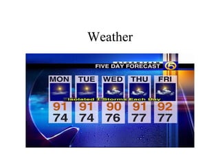
Weather unit and tools power point #1
- 1. Weather
- 2. What do we know about weather? How do people measure and predict the weather?
- 3. Meteorologist • A scientist who studies the weather • What kind of tools do they use?
- 4. Thermometer • Used to measure temperature • measures the kinetic energy of air molecules • Fahrenheit & Celsius thermometers
- 5. Anemometer • Measures wind speed • a system of gears converts the number of turns per minute into wind speed
- 6. Hygrometer • Measures humidity • the moisture in the air
- 7. Weather Vane • Measures wind direction • changes in wind usually lead to change in weather
- 8. Barometer • Measures air pressure • high pressure = clear cool skies • low pressure = cloudy skies, moist air • extreme low pressure = stormy weather
- 9. Cloud Conditions • Observing clouds can tell a lot about the weather
- 10. Cumulus • White & puffy • fair weather
- 11. Cirrus • High in the sky • white • thin & wispy • fair weather
- 12. Stratus • Low in the sky • thick & gray • usually bring rain
- 13. Cumulonimbus • Tower high into the sky • gray to black • Thunderstorms, hail, tornadoes • anvil shaped
- 14. How can rising air pressure lead to a prediction about weather?
- 15. Air Mass • A large body of air that has the same temperature and humidity throughout • take on the characteristics of the region over which they form • 4 types in the the USA
- 16. Air Masses – Categorized by moisture content and temperature – Moisture categories: m = maritime (wet) and c = continental (dry) – Temperature categories: P (polar; cold), T (Tropical; warm)
- 18. Continental Polar • Cool dry weather
- 19. Continental Tropical • Hot dry weather
- 20. Maritime polar • Cool humid weather
- 21. Maritime Tropical • Warm wet weather
- 22. Front • Border where two air masses meet • most weather changes occur along a front • cold front = cold air mass moves under a warm air mass creating cumulonimbus clouds • warm front = a warm air mass moves over a cold air mass forming stratus clouds
- 23. What kind of air mass causes hot humid weather?
- 24. Climate • The regular weather pattern for a region • precipitation & temperature determine climate • seasonal patterns • all patterns are driven by the sun • proximity to the equator determines temperature patterns
- 25. ????? • What is the cause of the seasons? • What are two major factors of climate? • What kind of climate would you find near the equator? • What kind of climate would you find at the poles?