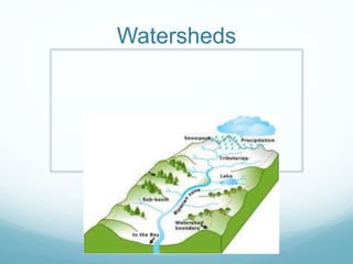
A watershed is an area of land that divides streams and rivers that drain into different bodies of water. Watersheds perform several important functions: they clean water through processes such as surface runoff and put the water into drinking condition. This is vital as the Mississippi watershed alone cleans and produces 40% of water for the United States. Watersheds are also important for recreation for animals and humans. There are 25 watersheds located within Canada.
The Silver Creek Super Project, in the Ocqueoc River Watershed (Presque Isle County, Mich.), embodies how locally driven efforts lead to broad partnerships and collaboration, successfully accomplishing full restoration of this highest quality tributary by treating stream impacts, invasive species, erosion, and by promoting many other conservation techniques. Protecting and restoring sensitive coldwater ecosystems is more important than ever, with increasing threats and ever dwindling financial support for that type of work. Yet, with the foundation of a system-wide inventory of watershed impacts and a watershed management plan in place, local partners have taken the lead in protecting their high-quality coldwater ecosystem, garnering interest from national organizations and agencies, including Great Lakes Restoration Initiative funding.
Sydney’s main source of water came from the tank stream in Sydney cove before it was polluted in 1826. Pipes were laid out throughout Sydney and we became more dependent on bore water. The Upper Nepean and Warragamba dam were considered to be the solution. The government has built Primary, Secondary and tertiary Wastewater treatment plants. These plants help remove solids, inorganic material, organic, metals, pathogens, nitrogen and phosphorus. Now the government has proposed a Desalination plant at Kurnell to help Sydney’s water crisis.
The history of efforts to preserve and protect the Ash Creek tidal estuary which borders the city of Bridgeport and the town of Fairfield in Connecticut. The Ash Creek Conservation Association was formed in 2003 to continue the efforts of many to protect this rare healthy tidal estuary in an urban area.
Water Shortages: What does it hold for Sydney? | Biocity StudioBiocity Studio
Climate change in the future will led to sea level rising, low rainfall, warmer days and water shortages through evaporation in the dams. A lesser amount of Sydney rain falls in the catchment area, as most of Sydney’s rain falls on the coast and the catchment areas are further island E.g. Warragamba Dam. Warragamba Dam is Sydney’s major water supply can supply Sydney with 4 years supply of water with zero inflow supply, but currently the dam is at 50% capacity. We now need to research desalination plants, larger scale water treatment plants and government plans and policies to help save our water supply.
Sydney's Water Sustainability | Biocity StudioBiocity Studio
Sydney is experiencing long-term droughts, low rainfall and a high demand for water. What can we do to help solve the water crisis? Water restrictions are only a short-term fix. Other solutions are desalination and recycle water plants, water management, and artificial precipitation.
National River Inventory - Jeff Simley, US Geological Surveyrshimoda2014
Explanation of the National Hydrography Dataset (NHD) which Jeff explains as 'essentially the surface water features found on topographic maps.' The NHD is the base of data on which the planned National River Recreation Database will live.
For a new better version of this tutorial see my Google Slides with embedded videos.
https://docs.google.com/presentation/d/1MftEOT3uvYpCVwUaLMhsesm5Que-Kr7GQRV4pKZ2SNQ/edit?usp=sharing
This is a 2016 tutorial on how to do watershed delineation using ArcMap 10. It is an open education resource. Please let me know if you find it useful or see something that could be improved. Feel free to use it for teaching Geographic Information Science.
Human Milk Feedings of High-Risk Infants - State of the Science, State of the Art. The Prolacta Bioscience mission is to make a meaningful difference in the lives of thousands of the most vulnerable infants through world class research and innovative products.
Where Land and Water Meet - Mike Swezy from Marin Municipal Water DistrictOpenSpaceCouncil
On March 17, 2016 (St Patty's Day!) we convened a Gathering with 4 water agencies to talk about land stewardship, drought, and partnerships. More info over at: http://openspacecouncil.org/community-events/gatherings/
Where Land and Water Meet - Mike Swezy from Marin Municipal Water DistrictAnnie Burke
On March 17, 2016 (St Patty's Day!) we convened a Gathering with 4 water agencies to talk about land stewardship, drought, and partnerships. More info over at: http://openspacecouncil.org/community-events/gatherings/
A Comprehensive Overview of Freshwater Usage in the United StatesMackenzie Grant
This infographic is titled “A Comprehensive Overview of Freshwater Usage in the United States.” It utilizes the data visually to allow readers to understand the full scope of our country’s water consumption.
https://htt.io/blog/freshwater-usage-united-states/
M
isso
uri R
.
Mississip
p
i R
.
Oh
io
R.
Gulf of Mexico
M
isso
uri R
.
Mississip
p
i R
.
Oh
io
R.
0
250 500 KILOMETERS0
250 500 MILES0
250 500 KILOMETERS0
250 500 MILES
▲Figure GN 14.1 Map of the Mississippi River basin.
409
GEOSYSTEMSnow
The Disappearing Delta Before modern engineering of the chan-
nel, the Mississippi River carried over 400 million metric tons of sedi-
ment annually to its mouth. River deposits built from this sediment
now underlie most of coastal Louisiana. Today, the flow carries less
than half its previous sediment load. This decline, combined with
land subsidence and sea-level rise, means that the delta region is
shrinking in size each year.
The tremendous weight of sediment deposition at the Mississip-
pi’s mouth has caused the entire delta region to lower as sediments
become compacted, a process that is worsened by human activities
such as oil and gas extraction. In the past, additions of sediment bal-
anced this subsidence, allowing the delta to build. With the onset
of human activities such as upstream dam construction, the delta is
now subsiding without sediment replenishment.
Compounding the problem is the maze of excavated canals
through the delta for shipping and oil and gas exploration. As the
land surface sinks, these canals allow seawater to flow inland,
changing the salinity of inland waters. Freshwater wetlands whose
roots help stabilize the land surface during floods are now declining.
This makes the delta more vulnerable to flooding from hurricane
storm surge, another factor hastening the delta’s demise.
Finally, sea-level rise threatens coastal land and wetlands, most
of which are less than 1 m (3.2 ft) above sea level. With continued
local sea-level rise, lands not protected by levee embankments and
other structures that prevent flooding will con-
tinue to submerge.
In this chapter, we examine the natural pro-
cesses by which rivers erode, transport, and de-
posit sediment, forming landforms such as deltas.
1. Why are engineers trying to keep the
Mississippi River in its present channel?
2. What three factors are causing the
Mississippi delta to disappear?
Changes on the
Mississippi River Delta
T
he immense Mississippi River basin
drains 41% of the continental United
States (Figure GN 14.1). From its head-
waters in Lake Itasca, Minnesota, the Missis-
sippi’s main stem flows southward, collecting
water and sediment over hundreds of miles.
As the river nears the Gulf of Mexico, the
flow energy diminishes and the river depos-
its its sediment load. This area of deposition
forms the delta, the low-lying plain at the
river’s end.
Like most rivers, the Mississippi continu-
ously changes its channel, seeking the short-
est and most efficient course to the ocean.
In southern Louisiana, the Mississippi’s chan-
nel has—over thousands of years—shifted
course across an area encompassing thou-
sands of square miles. Throughout this time
span, f ...
The Indian economy is classified into different sectors to simplify the analysis and understanding of economic activities. For Class 10, it's essential to grasp the sectors of the Indian economy, understand their characteristics, and recognize their importance. This guide will provide detailed notes on the Sectors of the Indian Economy Class 10, using specific long-tail keywords to enhance comprehension.
For more information, visit-www.vavaclasses.com
Synthetic Fiber Construction in lab .pptxPavel ( NSTU)
Synthetic fiber production is a fascinating and complex field that blends chemistry, engineering, and environmental science. By understanding these aspects, students can gain a comprehensive view of synthetic fiber production, its impact on society and the environment, and the potential for future innovations. Synthetic fibers play a crucial role in modern society, impacting various aspects of daily life, industry, and the environment. ynthetic fibers are integral to modern life, offering a range of benefits from cost-effectiveness and versatility to innovative applications and performance characteristics. While they pose environmental challenges, ongoing research and development aim to create more sustainable and eco-friendly alternatives. Understanding the importance of synthetic fibers helps in appreciating their role in the economy, industry, and daily life, while also emphasizing the need for sustainable practices and innovation.
How to Split Bills in the Odoo 17 POS ModuleCeline George
Bills have a main role in point of sale procedure. It will help to track sales, handling payments and giving receipts to customers. Bill splitting also has an important role in POS. For example, If some friends come together for dinner and if they want to divide the bill then it is possible by POS bill splitting. This slide will show how to split bills in odoo 17 POS.
This is a presentation by Dada Robert in a Your Skill Boost masterclass organised by the Excellence Foundation for South Sudan (EFSS) on Saturday, the 25th and Sunday, the 26th of May 2024.
He discussed the concept of quality improvement, emphasizing its applicability to various aspects of life, including personal, project, and program improvements. He defined quality as doing the right thing at the right time in the right way to achieve the best possible results and discussed the concept of the "gap" between what we know and what we do, and how this gap represents the areas we need to improve. He explained the scientific approach to quality improvement, which involves systematic performance analysis, testing and learning, and implementing change ideas. He also highlighted the importance of client focus and a team approach to quality improvement.
The Roman Empire A Historical Colossus.pdfkaushalkr1407
The Roman Empire, a vast and enduring power, stands as one of history's most remarkable civilizations, leaving an indelible imprint on the world. It emerged from the Roman Republic, transitioning into an imperial powerhouse under the leadership of Augustus Caesar in 27 BCE. This transformation marked the beginning of an era defined by unprecedented territorial expansion, architectural marvels, and profound cultural influence.
The empire's roots lie in the city of Rome, founded, according to legend, by Romulus in 753 BCE. Over centuries, Rome evolved from a small settlement to a formidable republic, characterized by a complex political system with elected officials and checks on power. However, internal strife, class conflicts, and military ambitions paved the way for the end of the Republic. Julius Caesar’s dictatorship and subsequent assassination in 44 BCE created a power vacuum, leading to a civil war. Octavian, later Augustus, emerged victorious, heralding the Roman Empire’s birth.
Under Augustus, the empire experienced the Pax Romana, a 200-year period of relative peace and stability. Augustus reformed the military, established efficient administrative systems, and initiated grand construction projects. The empire's borders expanded, encompassing territories from Britain to Egypt and from Spain to the Euphrates. Roman legions, renowned for their discipline and engineering prowess, secured and maintained these vast territories, building roads, fortifications, and cities that facilitated control and integration.
The Roman Empire’s society was hierarchical, with a rigid class system. At the top were the patricians, wealthy elites who held significant political power. Below them were the plebeians, free citizens with limited political influence, and the vast numbers of slaves who formed the backbone of the economy. The family unit was central, governed by the paterfamilias, the male head who held absolute authority.
Culturally, the Romans were eclectic, absorbing and adapting elements from the civilizations they encountered, particularly the Greeks. Roman art, literature, and philosophy reflected this synthesis, creating a rich cultural tapestry. Latin, the Roman language, became the lingua franca of the Western world, influencing numerous modern languages.
Roman architecture and engineering achievements were monumental. They perfected the arch, vault, and dome, constructing enduring structures like the Colosseum, Pantheon, and aqueducts. These engineering marvels not only showcased Roman ingenuity but also served practical purposes, from public entertainment to water supply.
Ethnobotany and Ethnopharmacology:
Ethnobotany in herbal drug evaluation,
Impact of Ethnobotany in traditional medicine,
New development in herbals,
Bio-prospecting tools for drug discovery,
Role of Ethnopharmacology in drug evaluation,
Reverse Pharmacology.
Model Attribute Check Company Auto PropertyCeline George
In Odoo, the multi-company feature allows you to manage multiple companies within a single Odoo database instance. Each company can have its own configurations while still sharing common resources such as products, customers, and suppliers.
2. Main groups
What is a watershed
A watersheds function
Why we use watersheds
The importance of watersheds
How a watershed cleans water
Quiz
Puzzle
3. What is a watershed
A watershed is a area/ridge of land that divides water
from flowing to different rivers, basins or seas.
There are 25 watersheds in Canada.
4. A watersheds function
Basin
Catchment
Upstream
Downstream
One body of water
Precipitation
5. Why we use watersheds
Watersheds are important because it cleans the water
enough for us to drink.
Watersheds are implementing water quality protection and
restoration services every day.
Fun Fact: The Mississippi watershed is the biggest
watershed in North America.
6. The importance of
watersheds
The Mississippi watershed cleans and produces 40% of
all the water in the United States.
Watersheds clean the water enough for us to drink.
Watersheds provide recreation for animals and people.
Watersheds also clean storm water by putting the water
into a surface runoff.
There are 25 watersheds in Canada.
7. How a watershed cleans
water
A watershed describes a piece of land that has a
set of streams and rivers that all drain into a
larger body of water, such as a larger river a lake
or a ocean.
8. Quiz
What percent of water does the Mississippi watershed
clean and produce for the United States?
How many watersheds are in Canada?
Where does all the water upstream go?
Where does all the water downstream go?
What is a watershed also known as?