Upsc geography
•
11 likes•1,436 views

Educaterer India is an unique combination of passion driven into a hobby which makes an awesome profession. We carve the lives of enthusiastic candidates to a perfect professional who can impress upon the mindsets of the industry, while following the established traditions, can dare to set new standards to follow. We don't want you to be the part of the crowd, rather we like to make you the reason of the crowd. Today's Effort For A Better Tomorrow

Recommended
More Related Content
What's hot
What's hot (20)
Similar to Upsc geography
Similar to Upsc geography (20)
More from Gautam Kumar
More from Gautam Kumar (20)
Recently uploaded
Recently uploaded (20)
Upsc geography
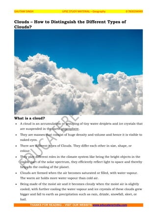
- 1. GAUTAM SINGH UPSC STUDY MATERIAL – Geography 0 7830294949 THANKS FOR READING – VISIT OUR WEBSITE www.educatererindia.com Clouds – How to Distinguish the Different Types of Clouds? What is a cloud? A cloud is an accumulation or grouping of tiny water droplets and ice crystals that are suspended in the earth atmosphere. They are masses that consist of huge density and volume and hence it is visible to naked eyes. There are different types of Clouds. They differ each other in size, shape, or colour. They play different roles in the climate system like being the bright objects in the visible part of the solar spectrum, they efficiently reflect light to space and thereby helps in the cooling of the planet. Clouds are formed when the air becomes saturated or filled, with water vapour. The warm air holds more water vapour than cold air. Being made of the moist air and it becomes cloudy when the moist air is slightly cooled, with further cooling the water vapour and ice crystals of these clouds grew bigger and fall to earth as precipitation such as rain, drizzle, snowfall, sleet, or hail.
- 2. GAUTAM SINGH UPSC STUDY MATERIAL – Geography 0 7830294949 THANKS FOR READING – VISIT OUR WEBSITE www.educatererindia.com What are the different types of cloud? Clouds are classified primarily based on – their shape and their altitude. 1. Classification of clouds – based on their shape: Based on shape, clouds are classified into three. They are: 1. Cirrus 2. Cumulus 3. Stratus 2. Classification of clouds – based on their altitude (height):
- 3. GAUTAM SINGH UPSC STUDY MATERIAL – Geography 0 7830294949 THANKS FOR READING – VISIT OUR WEBSITE www.educatererindia.com Based on the height or altitude the clouds are classified into three. They are – 1. High Clouds 2. Middle Clouds 3. Low Clouds Note: You should also note about the another type of clouds here – ie. Clouds with great vertical extent. 1) High Clouds They can reach above 6000 metres or 20,000 feet. They are also known as Cirrus Clouds. They are usually thin and are made up of ice. They often indicate fair weather and hence do not produce rain.
- 4. GAUTAM SINGH UPSC STUDY MATERIAL – Geography 0 7830294949 THANKS FOR READING – VISIT OUR WEBSITE www.educatererindia.com Types of High Clouds Description 1. Cirrus They are thin and often wispy cirrus clouds. Typically found at heights greater than 20,000 feet (6,000 meters), they are composed of ice crystals that originate from the freezing of supercooled water droplets. 2. Cirrostratus They are high, very thin, comprises a uniform layer, and are composed of ice-crystals. It is difficult to detect and is capable of forming halos when the cloud takes the form of thin cirrostratus nebulosus. 3. Cirrocumulus They are small rounded puffs shaped clouds, that usually appear in long rows high in the sky and are usually white, but sometimes appear grey. 2) Middle Clouds They form between 6,500 feet and cirrus level or from 2000 to 6000 metres. They are also known as “Alto” clouds. They frequently indicate an approaching storm. They may sometimes produce Virga, which is a rain or snow that does not reach the ground. Types of Middle Clouds Description 1. Altostratus These clouds are in the form of continuous sheet or veil, grey or blue-gray in colour. They are composed of ice crystals and water droplets. In its thinner areas, the sun can still be visible as a round, dim disk. These clouds may often form ahead of storms with continuous rain or snow.
- 5. GAUTAM SINGH UPSC STUDY MATERIAL – Geography 0 7830294949 THANKS FOR READING – VISIT OUR WEBSITE www.educatererindia.com 2. Altocumulus They are greyish sheet cloud, characterised by globular masses or rolls in layers or patches, the individual elements being larger and darker than those of cirrocumulus and smaller than those of stratocumulus. 3) Low Clouds They lie below 6,500 feet, which means from the surface to 2,000 meters. Low clouds are also known as Stratus Clouds. They may appear dense, dark, and rainy (or snowy) and can also be cottony white clumps interspersed with blue sky. Types of Low Clouds Description 1. Strato Cumulus Usually arranged in a large dark, rounded or globular masses, usually in groups, lines, or waves. 2. Stratus Usually looks like a huge grey blanket that hangs low in the sky that resembles fog, comprises uniform layer and appear dull, if these clouds are warm it means rain and if it is cold it snows. 3. Nimbostratus They are known as ‘Rain Clouds’ and they are dark, thick and accompanied by light to moderately falling precipitation. 4) Great Vertical Extent Clouds They are most dramatic types of clouds. Great Vertical Extent Clouds are also known as the Storm Clouds. They rise to dramatic heights, and sometimes well above the level of transcontinental jetliner flights.
- 6. GAUTAM SINGH UPSC STUDY MATERIAL – Geography 0 7830294949 THANKS FOR READING – VISIT OUR WEBSITE www.educatererindia.com Types of Great Vertical Extent Clouds Description 1. Cumulus They are convection clouds, puffy, that sometimes look like pieces of floating cotton. The base of each cloud is often flat and may be only 1000 meters (3300 feet) above the ground. The top of the cloud has rounded towers. 2. Cumulonimbus They are dense towering vertical cloud, it’s top acquiring an ‘Anvil Shape’, associated with thunderstorms and atmospheric instability, forming from water vapour carried by powerful upward air currents. How to learn all cloud types in a single diagram? Refer the below picture:
- 7. GAUTAM SINGH UPSC STUDY MATERIAL – Geography 0 7830294949 THANKS FOR READING – VISIT OUR WEBSITE www.educatererindia.com What is International Cloud Atlas?
- 8. GAUTAM SINGH UPSC STUDY MATERIAL – Geography 0 7830294949 THANKS FOR READING – VISIT OUR WEBSITE www.educatererindia.com The International Cloud Atlas describes the classification system for clouds and meteorological phenomena used by all World Meteorological Organization Members. It includes a manual of standards and photographs of clouds and weather phenomenon. It was first published in the 19th century and was last updated 30 years ago. The new 2017 version of International Cloud Atlas was a digitalized one and has many additions. The new cloud classifications that were introduced the International Cloud Atlas (2017) 1) The Species Volutus They are long, typically low, horizontal, detached, tube-shaped cloud mass. They often appear to roll slowly about a horizontal axis. The species volutus is a soliton and hence not attached to other clouds. This species applies mostly to Stratocumulus and rarely Altocumulus. 2) The Supplementary Features (a) Asperitas There are well-defined, wave-like structures in the underside of the cloud. Asperitas is characterised by localised waves in the cloud base, either smooth or dappled with smaller features, sometimes descending into sharp points, as if viewing a roughened sea surface from below. The varying levels of illumination and thickness of the cloud can lead to dramatic visual effects. They occur mostly with Stratocumulus and Altocumulus. (b) Fluctus They are relatively short-lived wave formation, usually seen on the top surface of the cloud, in the form of curls or breaking waves (Kelvin-Helmholtz waves). They occur mostly with Cirrus, Altocumulus, Stratocumulus, Stratus and occasionally Cumulus. (c) Cavum These are a well-defined generally circular hole in a thin layer of supercooled water droplet cloud.
- 9. GAUTAM SINGH UPSC STUDY MATERIAL – Geography 0 7830294949 THANKS FOR READING – VISIT OUR WEBSITE www.educatererindia.com The Cavum is typically a circular feature when viewed from directly beneath, but may appear oval-shaped when viewed from a distance. When resulting directly from the interaction of an aircraft with the cloud, it is generally linear. They occur in Altocumulus and Cirrocumulus and rarely Stratocumulus. (d) Murus It is a localised, persistent, and often abrupt lowering of cloud from the base of a Cumulonimbus from which tuba (spouts) sometimes form. Usually associated with a supercell or severe multi-cell storm. Murus showing significant rotation and vertical motion may result in the formation of tuba (spouts), Commonly known as a ‘wall cloud’. (e) Cauda A horizontal, tail-shaped cloud (not a funnel) at low levels extending from the main precipitation region of a supercell Cumulonimbus to the murus (wall cloud). It is typically attached to the wall cloud, and the bases of both are typically at the same height. Cloud motion is away from the precipitation area and towards the murus, with rapid upward motion often observed near the junction of the tail and wall clouds and are commonly known as a ‘tail cloud’. 3) Accessory Cloud Flumen They are bands of low clouds associated with a supercell severe convective storm (Cumulonimbus), arranged parallel to the low-level winds and moving into or towards the supercell. These accessory clouds form on an inflow band into a supercell storm along the pseudo-warm front. One particular type of inflow band cloud is the ‘Beaver’s tail’. This is distinguished by a relatively broad, flat appearance suggestive of a beaver’s tail. 4) Special Clouds (a) Flammagenitus These are clearly observed to have originated as a consequence of localised natural heat sources (forest fires, wildfires or volcanic activity) and consist of water drops. (b) Homogenitus These are originated specifically as a consequence of human activity.
- 10. GAUTAM SINGH UPSC STUDY MATERIAL – Geography 0 7830294949 THANKS FOR READING – VISIT OUR WEBSITE www.educatererindia.com They include aircraft condensation trails (contrails), or clouds resulting from industrial processes, such as cumuliform clouds generated by rising thermals above power station cooling towers. (c) Homomutatus These are formed as a result of persistent contrails (Cirrus homogenitus) that may be observed, over a period of time and under the influence of strong upper winds, to grow and spread out over a larger portion of the sky, and undergo internal transformation such that the cloud eventually takes on the appearance of more natural cirriform cloud. (d) Cataractagenitus They may develop locally in the vicinity of large waterfalls as a consequence of water broken up into spray by the falls. The Cataractagenitus are formed when the downdraft caused by the falling water is compensated for by the locally ascending motion of air. (e) Silvagenitus These are the clouds that may develop locally over the forests as a result of an increased humidity due to evaporation and evapotranspiration from the tree canopy. What is Asperitas Cloud? Asperitas is formerly known as Undulatus asperitus. It is a cloud formation proposed by Gavin Pretor-Pinney of the Cloud Appreciation Society (2009). It is recently been accepted and added to the International Cloud Atlas on March 23, 2017, on the occasion of World Meteorological Day. The ‘Asperitas’ is a Latin word and its meaning is ‘Rough‘. The Asperitas clouds tend to be low-lying and are caused by weather fronts that create undulating waves in the atmosphere. Why clouds appear white in colour? The clouds usually appear white because the tiny water droplets and ice crystals inside them are tightly packed, and they reflect most of the sunlight that falls on these masses (scattering). The tiny cloud particles equally scatter all colours of light, which make the viewer to perceive all wavelengths of sunlight mixed together as white light.
- 11. GAUTAM SINGH UPSC STUDY MATERIAL – Geography 0 7830294949 THANKS FOR READING – VISIT OUR WEBSITE www.educatererindia.com Why do clouds darken at the time of rain? The clouds appear dark or grey in colour at the time of rain is due to their particulate density. The water vapour will bind together into raindrops, leaving larger spaces between these drops of water and hence less amount of light is reflected, lending a darker appearance of the rain clouds.
- 12. GAUTAM SINGH UPSC STUDY MATERIAL – Geography 0 7830294949 THANKS FOR READING – VISIT OUR WEBSITE www.educatererindia.com Distribution of Temperature in the Earth’s Atmosphere In the previous articles in the Geography section, we have discussed in detail about the composition and structure of the earth’s atmosphere, how and from where the earth receives its energy, how the earth maintains its temperature, methods through which the heat energy gets transferred in the atmosphere (insolation and heat balance of the earth) etc. In this article, we are going to discuss the trend of distribution of temperature in the earth’s atmosphere. Difference between heat and temperature The interaction of incoming solar radiation (insolation) with the atmosphere and the earth’s surface creates heat. This is measured in terms of temperature. While heat represents the molecular movement of particles comprising a substance, the temperature is the measurement in degrees of how hot (or cold) a thing (or a place) is. So, heat is the energy which makes things or objects hot, while temperature measures the intensity of heat (degree of hotness/coldness). Heat and temperature are closely related to each other because gain or loss of heat is necessary to raise or lower the temperature. The Celsius scale is the internationally accepted scale for reporting air temperature. Fahrenheit scale and Kelvin scales are other scales used to measure temperature. The Fahrenheit temperature scale is based on 32 °F for the freezing point of water and 212 °F for the boiling point of water, with the interval between the two being divided into 180 parts. On the Kelvin scale, 0 K represents absolute zero (-273 °C), the temperature at which the molecules of a substance have their lowest possible energy.
- 13. GAUTAM SINGH UPSC STUDY MATERIAL – Geography 0 7830294949 THANKS FOR READING – VISIT OUR WEBSITE www.educatererindia.com Distribution of Temperature Distribution of temperature varies both horizontally and vertically. Let us study it under A) Horizontal Distribution of Temperature B) Vertical Distribution of Temperature A) Horizontal Distribution of Temperature Distribution of temperature across the latitudes over the surface of the earth is called its horizontal distribution. On maps, the horizontal distribution of temperature is commonly shown by isotherms. Isotherms are line connecting points that have an equal temperature.
- 14. GAUTAM SINGH UPSC STUDY MATERIAL – Geography 0 7830294949 THANKS FOR READING – VISIT OUR WEBSITE www.educatererindia.com When we analyse an isotherm map, it can be seen that the horizontal distribution of temperature is uneven. The factors responsible for the uneven horizontal distribution of temperature are: 1. Latitude In the previous article, we have studied that the angle of incidence of sun’s rays goes on decreasing from the equator towards the poles. Higher the angle of incidence, higher is the temperature. Similarly, lower the angle of incidence, lower is the temperature. This is why the temperature is higher near the tropical regions and decreases towards the poles. 2. Altitude As we all know, the temperature in the troposphere goes on decreasing with increase in height. Temperature decreases at an average rate of nearly 6 degree Celsius per 1000 m altitude, which is known as Normal Lapse Rate. 3. Land and Sea Contrast
- 15. GAUTAM SINGH UPSC STUDY MATERIAL – Geography 0 7830294949 THANKS FOR READING – VISIT OUR WEBSITE www.educatererindia.com Compared to land, the sea gets heated slowly and loses heat slowly. Land heats up and cools down quickly. As a result, the temperature is relatively higher on land during day time and it is higher in water during the night. Also, the places situated near the sea come under the moderating influence of the sea and land breezes which moderates the temperature. There are also seasonal variations in the temperature of land and sea. During summer, the air above land has a higher temperature than the oceans. But the air above oceans gets higher temperature than landmass in winter. Notwithstanding the great contrast between land and water surfaces, there are differences in the rate of heating of different land surfaces. A snow-covered land as in polar areas warms very slowly because of a large amount of reflection of solar energy. A vegetation covered land does not get excessively heated because a great amount of insolation is used in evaporating water from the plants. 4. Ocean Currents Ocean Currents are of two types – warm and cold. Warm currents make the coasts along which they flow warmer, while cold currents reduce the temperature of the coasts along which they flow. The North-Western European Coasts do not freeze in winter due to the effect of North Atlantic Drift (a warm current), while the Quebec on the coast of Canada is frozen due to the Cold Labrador Current flowing along it, though the Quebec is situated in lower latitudes than the North-West European Coast.
- 16. GAUTAM SINGH UPSC STUDY MATERIAL – Geography 0 7830294949 THANKS FOR READING – VISIT OUR WEBSITE www.educatererindia.com 5. Air Masses Like the land and sea breezes, the passage of air masses also affects the temperature. The places, which come under the influence of warm air masses experience higher temperature and the places that come under the influence of cold air masses experience low temperature. 6. Vegetation Cover Soil devoid of vegetation cover receives heat more rapidly than the soil under vegetation cover. Because vegetation cover absorbs much of sun’s heat and then prevents quick radiation from the earth whereas the former radiates it more rapidly. Hence the temperature variations in densely forested areas are lower than those in desert areas. Note: Along with these, the other factors which are responsible for the uneven horizontal distribution of temperature are winds, nature of the soil, slope and aspect of the surface, relief features, etc. The horizontal distribution of temperature over the globe can be studied easily from the isotherm maps of January and July months since the seasonal extremes
- 17. GAUTAM SINGH UPSC STUDY MATERIAL – Geography 0 7830294949 THANKS FOR READING – VISIT OUR WEBSITE www.educatererindia.com of high and low temperature are most obvious in both northern and southern hemispheres during these months. Horizontal Distribution of Temperature in January In January, the sun shines vertically overhead near the tropic of Capricorn. Hence, it is summer in southern hemisphere and winter in the northern hemisphere. A high temperature is found over the landmasses mainly in three regions of the southern hemisphere. These regions are North-West Argentina, East and Central Africa, and Central Australia. Isotherm of 30°C closes them. In the northern hemisphere, landmasses are cooler than the oceans. As the air is warmer over the oceans than over landmasses in the northern hemisphere, the isotherms bend towards the north (poles) when they cross the oceans and to the south (equator) over the continents. This can be clearly visible over the North Atlantic Oceans. The presence of warms ocean currents (Gulf Stream and North Atlantic Drift) make the Northern Atlantic Ocean warmer and the isotherms bend towards the poles. Over the land, the temperature decreases sharply and the isotherms bend towards the equator in Europe. In the southern hemisphere, the effect of the oceans is well pronounced (due to few landmasses). Here, the isotherms are more or less parallel to the latitudes and the variation in temperature is more gradual than in the northern hemisphere.
- 18. GAUTAM SINGH UPSC STUDY MATERIAL – Geography 0 7830294949 THANKS FOR READING – VISIT OUR WEBSITE www.educatererindia.com Horizontal Distribution of Temperature in July In July, the sun shines vertically overhead near the Tropic of cancer. Hence, high temperatures are found in the entire northern hemisphere. The regions having high temperature include South Western USA, the Sahara, the Arabia, Iraq, Iran, Afghanistan, desert region of India and China. However, the lowest temperature of 0°C is also noticed in the Northern Hemisphere during summer in the central part of Greenland. During summer in the northern hemisphere, isotherms bend towards the equator while crossing oceans and towards the poles while crossing landmasses. Isotherms are wide spaced over oceans while they are closely spaced over landmasses. In July, the deviation of isotherms is not that much pronounced as in January. B) Vertical Distribution of Temperature We have already studied that the temperature in the troposphere decreases with an increase in the altitude. This vertical gradient of temperature is commonly referred to as the standard atmosphere or Normal Lapse Rate. However, this normal lapse rate varies with height, season, latitude and other factors. Indeed the actual lapse rate of temperature does not always show a decrease with altitude.
- 19. GAUTAM SINGH UPSC STUDY MATERIAL – Geography 0 7830294949 THANKS FOR READING – VISIT OUR WEBSITE www.educatererindia.com Inversion of Temperature The phenomenon in which temperature increases with increasing altitude temporarily and locally under certain conditions is known as inversion of temperature. Inversion is usually of short duration but quite common nonetheless. Long winter night, clear sky, dry air and absence of winds leads to quick radiation of heat from the earth’s surface, as well as from the lower layers of the atmosphere. This results in the cooling of the air near the earth’s surface. The upper layers which lose their heat not so quickly are comparatively warm. Hence the normal condition, in which temperature decreases with increasing height, is reversed. The cooler air is nearer the earth and the warmer air is aloft. In other words, temperature increases with increasing height temporarily or locally. The phenomenon of inversion of temperature is mostly observed in intermontane valleys due to air drainage. During winters the mountain slopes cool very rapidly due to the quick radiation of heat. The air resting above them also becomes cold and its density increases. Hence, it moves down the slopes and settles down in the valleys. This air pushes the comparatively warmer air of valleys upwards and leads to the phenomenon of inversion of temperature. Sometimes the temperature falls below freezing point in the valleys leading even to the occurrence of frost. In contrast, the higher slopes remain comparatively warmer. This movement of heavy and dense cold air towards the valley slopes almost like water is termed as air drainage.
- 20. GAUTAM SINGH UPSC STUDY MATERIAL – Geography 0 7830294949 THANKS FOR READING – VISIT OUR WEBSITE www.educatererindia.com Insolation and Heat Balance of the Earth In the previous article, we have discussed the composition and structure of the earth’s atmosphere. The atmosphere is essential for the survival of plant and animal life. They also require the optimum temperature to keep themselves warm and grow. In this article, we are going to discuss in details about some of the topics like insolation, terrestrial radiation, heat budget of the earth, albedo, etc. Insolation or Incoming Solar Radiation As we all know, the sun is the primary source of energy for the earth. The sun radiates its energy in all directions into space in short wavelengths, which is known as solar radiation. The earth’s surface receives only a part of this radiated energy (2 units out of 1,00,00,00,000 units of energy radiated by the sun). The energy received by the earth’s surface in the form of short waves is termed as Incoming Solar Radiation or Insolation. The amount of insolation received on the earth’s surface is far less than that is radiated from the sun because of the small size of the earth and its distance from the sun. Moreover, water vapour, dust particles, ozone and other gases present in the atmosphere absorb a small amount of solar radiation.
- 21. GAUTAM SINGH UPSC STUDY MATERIAL – Geography 0 7830294949 THANKS FOR READING – VISIT OUR WEBSITE www.educatererindia.com The solar radiation received at the top of the atmosphere varies slightly in a year due to the variations in the distance between the earth and the sun. During the earth’s revolution around the sun, the earth is farthest from the sun on 4th July. This position of the earth is called aphelion. On 3rd January, the earth is nearest to the sun. This position is called perihelion. Due to this variation in the distance between the earth and the sun, the annual insolation received by the earth on 3rd January is slightly more than the amount received on 4th July. However, the effect of this variation is masked by some other factors like the distribution of land and sea and the atmospheric circulation. Hence the variation does not have a greater effect on daily weather changes on the surface of the earth. Factors influencing Insolation The amount of insolation received on the earth’s surface is not uniform everywhere. It varies according to the place and time. When the tropical regions receive maximum annual insolation, it gradually decreases towards the poles. Insolation is more in summers and less in winters. The major factors which influence the amount of insolation received are: 1. Rotation of the earth on its axis 2. The angle of incidence of the sun’s rays
- 22. GAUTAM SINGH UPSC STUDY MATERIAL – Geography 0 7830294949 THANKS FOR READING – VISIT OUR WEBSITE www.educatererindia.com 3. Duration of the day 4. Transparency of the atmosphere 1. Rotation of the earth on its axis The earth rotates on its own axis which makes an angle of 66.5 with the plane of its orbit around the sun. The rotation of the earth on this inclined axis has a greater influence on the amount of insolation received at different latitudes. 2. The angle of incidence of the sun’s rays Since the earth is a geoid resembling a sphere, the sun’s rays strike the surface at different angles at different places. This depends on the latitude of the place. The higher the latitude, the less is the angle they make with the surface of the earth. The area covered by the vertical rays is always less than the slant rays. If more area is covered, the energy gets distributed and the net energy received per unit area decreases. Moreover, the sun’s rays with small angle traverse more of the atmosphere than rays striking at a large angle.
- 23. GAUTAM SINGH UPSC STUDY MATERIAL – Geography 0 7830294949 THANKS FOR READING – VISIT OUR WEBSITE www.educatererindia.com Longer the path of the sun’s rays, greater is the amount of reflection and absorption of heat by the atmosphere. As a result, the intensity of insolation is less. 3. Duration of the day Duration of the day varies from place to place and season to season. It decides the amount of insolation received on the earth’s surface. The longer the duration of the day, the greater is the amount of insolation received. Conversely shorter the duration of the day leads to receipt of less insolation. 4. Transparency of the atmosphere The transparency of the atmosphere depends upon the cloud cover and its thickness, dust particles, water vapour, etc. They reflect, absorb or transmit insolation.
- 24. GAUTAM SINGH UPSC STUDY MATERIAL – Geography 0 7830294949 THANKS FOR READING – VISIT OUR WEBSITE www.educatererindia.com Thick cloud hinders the solar radiation to reach the earth’s surface. Similarly, water vapour absorbs solar radiation resulting in less amount of insolation reaching the surface. When the solar radiation passes through the atmosphere, water vapour, ozone and other gases absorb much of the near infrared radiation (mainly in the troposphere). Very small suspended particles in the troposphere scatter visible spectrum both to space and towards the earth’s surface. This process adds colour to the sky. The red colour of the rising and the setting sun and the blue colour of the sky are the results of scattering of the light within the atmosphere. Note: Maximum insolation is received over the subtropical desert, where the cloudiness is the least. The equator receives comparatively less insolation than the tropics. Generally, at the same latitude, the insolation is more over the continent than over the oceans. In winter, the middle and higher latitudes receive less radiation than in summer.
- 25. GAUTAM SINGH UPSC STUDY MATERIAL – Geography 0 7830294949 THANKS FOR READING – VISIT OUR WEBSITE www.educatererindia.com Heating and Cooling of the Atmosphere The sun is the ultimate source of atmospheric heat and energy. There are different ways of heating and cooling of the atmosphere. They are: 1. Terrestrial Radiation 2. Conduction 3. Convection 4. Advection 1. Terrestrial Radiation Before discussing terrestrial radiation, the following facts about radiation are worth noting. i) All objects whether hot or cold emit radiant energy continuously. ii) Hotter objects emit more energy per unit area than colder objects. iii) The temperature of an object determines the wavelength of radiation. Temperature and wavelength are inversely proportional. Hotter the object, shorter is the length of the wave. So, when the earth’s surface after being heated up by the insolation (in the form of short waves), it becomes a radiating body. The earth’s surface starts to radiate energy to the atmosphere in the form of long waves. This is what we call as terrestrial radiation. This energy heats up the atmosphere from bottom to top. It should be noted that the atmosphere is transparent to short waves and opaque to long waves. The long-wave radiation is absorbed by the atmospheric gases particularly by carbon dioxide and other greenhouse gases. Thus, the atmosphere is indirectly heated by the terrestrial radiation. The atmosphere, in turn, radiates and transmits heat to space. Finally, the amount of heat received from the sun is returned to space, thereby maintaining a constant temperature at the earth’s surface and in the atmosphere. 2. Conduction (transfer of heat by contact)
- 26. GAUTAM SINGH UPSC STUDY MATERIAL – Geography 0 7830294949 THANKS FOR READING – VISIT OUR WEBSITE www.educatererindia.com Conduction is the process of heat transfer from a warmer object to a cooler object when they come in contact with each other. The flow of heat energy continues till the temperature of both the objects become equal or the contact is broken. The conduction in the atmosphere occurs at the zone of contact between the atmosphere and the earth’s surface. Conduction is important in heating the lower layers of the atmosphere. 3. Convection (vertical transfer of heat) Transfer of heat by the movement of a mass or substance from one place to another, generally vertical, is called convection. The air of the lower layers of the atmosphere gets heated either by the earth’s radiation or by conduction. The heating of the air leads to its expansion. Its density decreases and it moves upwards. The continuous ascent of heated air creates a vacuum in the lower layers of the atmosphere. As a consequence, cooler air comes down to fill the vacuum, leading to convection. The cyclic movement associated with the convectional process in the atmosphere transfer heat from the lower layer to the upper layer and heats up the atmosphere. The convection transfer of energy is confined only to the troposphere.
- 27. GAUTAM SINGH UPSC STUDY MATERIAL – Geography 0 7830294949 THANKS FOR READING – VISIT OUR WEBSITE www.educatererindia.com 4. Advection (horizontal transfer of heat) The transfer of heat through horizontal movement of air (wind) is called advection. Winds carry the temperature of one place to another. The temperature of a place will rise if it lies in the path of winds coming from warmer regions. The temperature will fall if the place lies in the path of the winds blowing from cold regions. Horizontal movement of the air is relatively more important than the vertical movement. In the middle latitudes, most of diurnal (day and night) variations in daily weather are caused by advection alone. In tropical regions particularly in northern India during the summer season, local winds called ‘Loo’is the outcome of advection process. Heat Budget of the Earth The earth as a whole does not accumulate or lose heat. It maintains its temperature. This can happen only if the amount of heat received in the form of insolation equals the amount lost by the earth through terrestrial radiation. This balance between the insolation and the terrestrial radiation is termed as the heat budget or heat balance of the earth.
- 28. GAUTAM SINGH UPSC STUDY MATERIAL – Geography 0 7830294949 THANKS FOR READING – VISIT OUR WEBSITE www.educatererindia.com This is why the earth neither warms up nor cools down despite the huge transfer of heat that takes place. Albedo Albedo can be simply defined as a measure of how much light that hits a surface is reflected back without being absorbed. It is a reflection coefficient and has a value less than one. When the solar radiation passes through the atmosphere, some amount of it is reflected, scattered and absorbed. The reflected amount of radiation is called as the albedo of the earth. The value of albedo will be different for different surfaces.
- 29. GAUTAM SINGH UPSC STUDY MATERIAL – Geography 0 7830294949 THANKS FOR READING – VISIT OUR WEBSITE www.educatererindia.com Because of the effect of albedo, highly developed areas such as urban cities can experience higher average temperatures than the surrounding suburban or rural areas, a phenomenon known as the “Urban Heat Island Effect”. The higher average temperature can be attributed to less vegetation, higher population densities, and more infrastructures with dark surfaces (asphalt roads, brick buildings, etc.). Variation in the net budget at the earth’s surface Although the earth as a whole maintains a balance between the insolation and the terrestrial radiation, this is not true what we observe at different latitudes. As we have discussed earlier, there are variations in the amount of insolation received at different latitudes. In the tropical region, the amount of insolation is higher than the amount of terrestrial radiation. Hence it is a region of surplus heat. In the polar region, the heat gain is less than the heat loss. Hence it is a region of deficit heat.
- 30. GAUTAM SINGH UPSC STUDY MATERIAL – Geography 0 7830294949 THANKS FOR READING – VISIT OUR WEBSITE www.educatererindia.com Thus the insolation creates an imbalance of heat at different latitudes. This imbalance is nullified to some extent by winds and ocean currents, which transfer heat from surplus heat regions to deficit heat regions. This process of redistribution and balancing of latitudinal heat is commonly known as Latitudinal Heat Balance.
- 31. GAUTAM SINGH UPSC STUDY MATERIAL – Geography 0 7830294949 THANKS FOR READING – VISIT OUR WEBSITE www.educatererindia.com Composition and Structure of the Earth’s Atmosphere What is atmosphere? We all know that earth is a unique planet due to the presence of life. The air is one among the necessary conditions for the existence of life on this planet. The air is a mixture of several gases and it encompasses the earth from all sides. The air surrounding the earth is called the atmosphere. Atmosphere is the air surrounding the earth. The atmosphere is a mixture of different gases. It contains life-giving gases like Oxygen for humans and animals and carbon dioxide for plants. It envelops the earth all round and is held in place by the gravity of the earth. It helps in stopping the ultraviolet rays harmful to the life and maintains the suitable temperature necessary for life. Generally, atmosphere extends up to about 1600 km from the earth’s surface. However, 99 % of the total mass of the atmosphere is confined to the height of 32 km from the earth’s surface. Composition of the atmosphere The atmosphere is made up of different gases, water vapour and dust particles.
- 32. GAUTAM SINGH UPSC STUDY MATERIAL – Geography 0 7830294949 THANKS FOR READING – VISIT OUR WEBSITE www.educatererindia.com The composition of the atmosphere is not static and it changes according to the time and place. Gases of the atmosphere The atmosphere is a mixture of different types of gases. Nitrogen and oxygen are the two main gases in the atmosphere and 99 percentage of the atmosphere is made up of these two gases. Other gases like argon, carbon dioxide, neon, helium, hydrogen, etc. form the remaining part of the atmosphere. The portion of the gases changes in the higher layers of the atmosphere in such a way that oxygen will be almost negligible quantity at the heights of 120 km. Similarly, carbon dioxide (and water vapour) is found only up to 90 km from the surface of the earth. Carbon dioxide: Carbon dioxide is meteorologically a very important gas. It is transparent to the incoming solar radiation (insolation) but opaque to the outgoing terrestrial radiation.
- 33. GAUTAM SINGH UPSC STUDY MATERIAL – Geography 0 7830294949 THANKS FOR READING – VISIT OUR WEBSITE www.educatererindia.com It absorbs a part of terrestrial radiation and reflects back some part of it towards the earth’s surface. Carbon dioxide is largely responsible for the greenhouse effect. When the volume of other gases remains constant in the atmosphere, the volume of the carbon dioxide has been rising in the past few decades mainly because of the burning of fossil fuels. This rising volume of carbon dioxide is the main reason for global warming. Ozone gas: Ozone is another important component of the atmosphere found mainly between 10 and 50 km above the earth’s surface. It acts as a filter and absorbs the ultra-violet rays radiating from the sun and prevents them from reaching the surface of the earth. The amount of ozone gas in the atmosphere is very little and is limited to the ozone layer found in the stratosphere. Water Vapour Gases form of water present in the atmosphere is called water vapour. It is the source of all kinds of precipitation. The amount of water vapour decreases with altitude. It also decreases from the equator (or from the low latitudes) towards the poles (or towards the high latitudes). Its maximum amount in the atmosphere could be up to 4% which is found in the warm and wet regions. Water vapour reaches in the atmosphere through evaporation and transpiration. Evaporation takes place in the oceans, seas, rivers, ponds and lakes while transpiration takes place from the plants, trees and living beings. Water vapour absorbs part of the incoming solar radiation (insolation) from the sun and preserves the earth’s radiated heat. It thus acts like a blanket allowing the earth neither to become too cold nor too hot. Water vapour also contributes to the stability and instability in the air. Dust Particles Dust particles are generally found in the lower layers of the atmosphere.
- 34. GAUTAM SINGH UPSC STUDY MATERIAL – Geography 0 7830294949 THANKS FOR READING – VISIT OUR WEBSITE www.educatererindia.com These particles are found in the form of sand, smoke-soot, oceanic salt, ash, pollen, etc. Higher concentration of dust particles is found in subtropical and temperate regions due to dry winds in comparison to equatorial and polar regions. These dust particles help in the condensation of water vapour. During the condensation, water vapour gets condensed in the form of droplets around these dust particles and thus clouds are formed. Structure of the atmosphere The atmosphere can be divided into five layers according to the diversity of temperature and density. They are: 1. Troposphere 2. Stratosphere 3. Mesosphere 4. Thermosphere (Ionosphere) 5. Exosphere
- 35. GAUTAM SINGH UPSC STUDY MATERIAL – Geography 0 7830294949 THANKS FOR READING – VISIT OUR WEBSITE www.educatererindia.com Troposphere It is the lowermost layer of the atmosphere. The height of this layer is about 18 km on the equator and 8 km on the poles. The thickness of the troposphere is greatest at the equator because heat us transported to great heights by strong convectional currents. Troposphere contains dust particles and water vapour. This is the most important layer of the atmosphere because all kinds of weather changes take place only in this layer. The air never remains static in this layer. Therefore this layer is called ‘changing sphere’ or troposphere. The environmental temperature decreases with increasing height of the atmosphere. It decreases at the rate of 1 degree Celsius for every 165 m of height. This is called Normal Lapse Rate. The zone separating troposphere from the stratosphere is known as tropopause. The air temperature at the tropopause is about – 80 degree Celsius over the equator and about – 45 degree Celsius over the poles. The temperature here is nearly constant, and hence, it is called tropopause. Stratosphere Stratosphere is found just above the troposphere. It extends up to a height of 50 km. The temperature remains almost the same in the lower part of this layer up to the height of 20 km. After this, the temperature increases slowly with the increase in the height. The temperature increases due to the presence of ozone gas in the upper part of this layer. Weather related incidents do not take place in this layer. The air blows horizontally here. Therefore this layer is considered ideal for flying of aircraft. The upper limit of the stratosphere is known as stratopause. One important feature of stratosphere is that it contains a layer of ozone gas. The relative thickness of the ozone layer is measured in Dobson Units. It is mainly found in the lower portion of the stratosphere, from approximately 20 to 30 km above the earth’s surface.
- 36. GAUTAM SINGH UPSC STUDY MATERIAL – Geography 0 7830294949 THANKS FOR READING – VISIT OUR WEBSITE www.educatererindia.com It contains a high concentration of ozone (O3) in relation to other parts of the atmosphere. It is the region of the stratosphere that absorbs most of the sun’s ultra-violet radiations. Mesosphere It is the third layer of the atmosphere spreading over the stratosphere. It extends up to a height of 80 km. In this layer, the temperature starts decreasing with increasing altitude and reaches up to – 100 degree Celsius at the height of 80 km. Meteors or falling stars occur in this layer. The upper limit of the mesosphere is known as mesopause. Thermosphere This layer is located between 80 and 400 km above the mesopause. It contains electrically charged particles known as ions, and hence, it is known as the ionosphere. Radio waves transmitted from the earth are reflected back to the earth by this layer and due to this, radio broadcasting has become possible. The temperature here starts increasing with heights. Exosphere The exosphere is the uppermost layer of the atmosphere. Gases are very sparse in this sphere due to the lack of gravitational force. Therefore, the density of air is very less here.
- 37. GAUTAM SINGH UPSC STUDY MATERIAL – Geography 0 7830294949 THANKS FOR READING – VISIT OUR WEBSITE www.educatererindia.com Ocean Currents – Shortcut method by to learn faster In our geography notes on the hydrosphere, we have seen the major movements of the ocean water. They are – waves, tides and ocean currents. Having covered the fundamentals, we shall see in this post, a super-fast way to learn the details of ocean currents. Names, direction, nature….and what not! Well, you might have heard so many names like Kuroshio current, Oyashio current, Peru current etc. Is Kuroshio a cold current or warm current? Where is its location? It’s not easy to remember all the names, location and type (warm or cold) of ocean currents – without the right guidance. UPSC often ask questions in Prelims and Mains from the topic of ocean currents. So, what is the short-cut approach to learn fast? Well, wait and see. How to learn the names of ocean currents, faster? ClearIAS has prepared a mind map from the above map. We have shown the major current systems in the three oceans – Atlantic ocean, Indian ocean and Pacific ocean –
- 38. GAUTAM SINGH UPSC STUDY MATERIAL – Geography 0 7830294949 THANKS FOR READING – VISIT OUR WEBSITE www.educatererindia.com from left to right. Continents are represented in ‘Green’, warm ocean currents in ‘Red’, and cold ocean currents in ‘Blue’. Hope it’s easy now! What are the points to remember? There are gyres in each of the oceans – The Pacific, Atlantic and Indian ocean. (Any large system of rotating ocean current, particularly those involved with large wind movements is called as a Gyre.). Current direction: In general, currents in the northern hemisphere travel in the clockwise direction in a gyre, while currents in southern hemisphere travel in the anti-clockwise direction ( the only exception is the current direction in the Indian ocean, which changes seasonally.) The ocean current movement in the north-Atlantic gyre, as well as north-Pacific gyre, is clockwise, while the gyres in the Southern hemisphere are anti-clockwise. Current temperature: In general, currents in the western part of every continent are cold (the exceptions are mentioned in the article on movements of the ocean water). Currents coming from the polar region are generally cold. Currents near to equator are generally warm. There is a counter-equatorial current, which moves from west to east (warm).
- 39. GAUTAM SINGH UPSC STUDY MATERIAL – Geography 0 7830294949 THANKS FOR READING – VISIT OUR WEBSITE www.educatererindia.com The west-wind drift moves from west to east (cold) Now, that’s the only quick notes you need to learn the flow pattern of ocean currents. With the above points, you can find the nature of almost all currents. Let’s analyse the major ocean currents. 1. North Equatorial Current It is a significant Pacific and the Atlantic Ocean current that flows from east to west. They flow in between 100 north and 200 north latitudes. Despite its name, the North Equatorial Current is not connected to the equator. In both oceans, it is separated from the equatorial circulation by the equatorial countercurrent, which flows eastward. 2. South Equatorial Current It is a significant ocean current in the Pacific, Atlantic and the Indian Ocean that flows from east to west. They flow in between the equator and about 200 south. In the Pacific and Atlantic Oceans, it extends across the equator to about 50 north. 3. Equatorial Counter Current It is an eastward flowing current found in the Atlantic, Indian and Pacific Oceans. It is found in between the North Equatorial and South Equatorial Currents at about 3-100 northern latitudes. This counter-current replaces the water removed from the eastern side of the ocean by the North Equatorial and South Equatorial Currents. In the Indian Ocean, the current tends to reverse hemispheres seasonally due to the impact of reversing Asian monsoons. 4. Antarctic Circumpolar Current or West Wind Drift It is an ocean current that flows from west to east around the Antarctica. The current is circumpolar due to the lack of any landmass connecting with the Antarctica and thus keeps warm ocean waters away from the Antarctica.
- 40. GAUTAM SINGH UPSC STUDY MATERIAL – Geography 0 7830294949 THANKS FOR READING – VISIT OUR WEBSITE www.educatererindia.com The Antarctic Convergence is associated with this current. It is the region where the cold Antarctic waters meet the water of the Sub-Antarctic, creating a zone of upwelling (a zone of very high marine productivity). Gyres of Ocean Currents in each of the major Oceans The major loops are seen in Pacific Ocean, Atlantic Ocean and the Indian Ocean in both the hemispheres. Each of the currents follows more or less a definite pattern. But the currents in the Indian Ocean (Northern Hemisphere) change the flow-direction between summer and winter. Currents of the Atlantic Ocean To the north and south of the equator, there are two westward moving currents, i.e., the North and the South Equatorial Currents. Between these two, there is the counter equatorial current which moves from west to east. Atlantic Ocean: Northern Hemisphere The South Equatorial Current bifurcates into two branches near the Cape De Sao Roque in Brazil and its northern branch joins the North Equatorial Current.
- 41. GAUTAM SINGH UPSC STUDY MATERIAL – Geography 0 7830294949 THANKS FOR READING – VISIT OUR WEBSITE www.educatererindia.com A part of this combined current enters the Caribbean Sea and the Gulf of Mexico, while the remaining current passes along the eastern side of the West Indies as the Antilles Current. The part of the current which enters the Gulf of Mexico comes out from the Florida Straight and joins the Antilles current. This combined current moves along the south-eastern coast of the U.S.A and is known as the Florida Current up to Cape of Hatteras. Beyond Cape of Hatteras, it is known as the Gulf Stream. A cold current from the Arctic Ocean called Labrador Current, which flows along the eastern coast of Canada, meets the warm Gulf Stream near the north-east corner of U.S.A. The confluence of these two currents, one cold and the other warm, produce fog around the region and makes it the most important fishing ground in the world. The Gulf Stream then deflected eastward under the combined influence of the westerlies and the rotation of the earth. It then crosses the Atlantic Ocean as the warm North Atlantic Drift. In this journey, another cold current from the Arctic called as the East Greenland Current joins with the North Atlantic Drift.
- 42. GAUTAM SINGH UPSC STUDY MATERIAL – Geography 0 7830294949 THANKS FOR READING – VISIT OUR WEBSITE www.educatererindia.com The North Atlantic Drift bifurcates into two branches on reaching the eastern part of the ocean. The northern branch continues as North Atlantic Drift; reaches the British Isles from where it flows along the coast of Norway as the warm Norwegian Current and enters the Arctic Ocean. The southern branch flows between Spain and Azores Island as the cold Canaries Current. The Canaries Current finally joins the North Equatorial Current and completes the circuit. Atlantic Ocean: Southern Hemisphere The South Equatorial Current turns south and flows along the eastern coast of South America as Brazil Current. At about 350 south latitude, due to the influence of westerlies and the rotation of the earth, the current moves eastward. A cold current called as the Falkland Current which flows along the south- eastern coast of South America from south to north joins with the current at this time. The Brazil Current moves eastward and crosses the Atlantic Ocean as South Atlantic Current. A part of the west wind drift or the Antarctic Circumpolar Current merges with the South Atlantic Current while crossing the Atlantic.
- 43. GAUTAM SINGH UPSC STUDY MATERIAL – Geography 0 7830294949 THANKS FOR READING – VISIT OUR WEBSITE www.educatererindia.com Near the Cape of Good Hope, the South Atlantic Current is diverted northward as the Cold Benguela Current. Benguela Current finally joins with the South Equatorial Current and completes the circuit. Currents of the Pacific Ocean Pacific Ocean: Northern Hemisphere The North Equatorial Current turns northward and flows along the Philippines Islands, Taiwan, and Japan to form the warm Kuro Shio or Kuro Siwo current. Later, a cold current called Oya Shio or Oya Siwo which flows along the eastern coast of the Kamchatka Peninsula merges with the Kuro Shio Current (Okhotsk Current is a cold current which merges with the Oya Shio before its confluence with Kuro Shio). From south-east coast of Japan, the Kuro Shio current comes under the influence of westerlies and flow right across the ocean as the North Pacific Current. After reaching the west coast of North America, it bifurcates into two branches: the northern branch flows anti-clockwise along the coast of Alaska as warm Alaska Current and the southern branch moves southward along the coast of California as the cold California Current. California Current eventually joins with the North Equatorial Current and completes the circuit.
- 44. GAUTAM SINGH UPSC STUDY MATERIAL – Geography 0 7830294949 THANKS FOR READING – VISIT OUR WEBSITE www.educatererindia.com Pacific Ocean: Southern Hemisphere In the South Pacific Ocean, the South Equatorial Current flows towards the west and turns southward as the East Australian Current. From Tasmania, it flows as the cold South Pacific Current from west to east and crosses the Pacific Ocean along with the West Wind Drift. On reaching the south-western coast of South America, it turns northward and flows as the cold Peru Current or Humbolt Current. The cold waters of the Peru Current are partially responsible for making the coast of the northern Chile and western Peru with very scanty rainfall. Peru Current eventually joins with the South Equatorial Current and completes the circuit. Currents of the Indian Ocean The pattern of circulation of ocean currents in the Indian Ocean differs from the general pattern of circulation in the Atlantic and the Pacific Oceans. This is because the Indian Ocean is blocked by the continental masses in the north. The general pattern of circulation in the southern hemisphere of the Indian Ocean is anti-clockwise as that of the other oceans. In the northern hemisphere, there is a clear reversal of currents in the winter and summer seasons, which are completely under the influence of the seasonal changes of monsoon winds. Indian Ocean: Northern Hemisphere during winter
- 45. GAUTAM SINGH UPSC STUDY MATERIAL – Geography 0 7830294949 THANKS FOR READING – VISIT OUR WEBSITE www.educatererindia.com During winter, Sri Lanka divides the currents of the Arabian Sea from those of the Bay of Bengal. The North East Monsoon Drift flows westward just south of Sri Lanka with a countercurrent flow between it and the South Equatorial Current. During the winter season, in the northern section, the Bay of Bengal and the Arabian Sea are under the influence of North East Monsoon Winds. These North East Monsoon winds drive the waters of the Bay of Bengal and the Arabian Sea westward to circulate in an anti-clockwise direction. Indian Ocean: Northern Hemisphere during summer
- 46. GAUTAM SINGH UPSC STUDY MATERIAL – Geography 0 7830294949 THANKS FOR READING – VISIT OUR WEBSITE www.educatererindia.com In summer, the northern part comes under the influence of the South West Monsoon. It results in an easterly movement of water in the Bay of Bengal and the Arabian Sea in a clockwise direction. This current is called as the South West Monsoon Drift. In the Indian Ocean, the summer currents are more regular than those of the winter. Indian Ocean: Southern Hemisphere In the southern part, the South Equatorial Current which flows from east to west is strengthened by its corresponding current of the Pacific Ocean. It then turns southward along the coast of Mozambique in Africa. A part of this current moving in between the African mainland and the Mozambique is called as the warm Mozambique Current. After the confluence of these two parts, the current is called as Agulhas Current. Agulhas Current merges with the West Wind Drift when it crosses the Indian Ocean. A branch of this merged current flows along the western coast of the Australia as cold West Australian Current. It later joins with the South Equatorial Current to complete the circuit. Summary As mentioned above, the quick-way to remember ocean currents is to remember the gyres. Currents in the western part of every continent is cold. Currents coming from the polar region are generally cold. Currents near to equator are generally warm.
- 47. GAUTAM SINGH UPSC STUDY MATERIAL – Geography 0 7830294949 THANKS FOR READING – VISIT OUR WEBSITE www.educatererindia.com Movements of ocean water: Waves, Tides and Ocean Currents Our Geography notes continue. Having covered the most important concepts in land, we are now dealing with the water (hydrosphere). In the last article, we have seen the ocean bottom topography. In this comprehensive post, we will cover the movements of ocean water – waves, tides and ocean currents. We hope the notes will turn highly handy for quick learning and last-minute revision. Movements of ocean water: The classification You all know that the ocean water is never still. There are different types of movements of ocean water under the influence of different physical characteristics like temperature, salinity, density, etc. Movements of ocean water are also affected by external forces like the sun, moon and the winds. The major movements of the ocean waters can be classified into three. They are: 1. Waves 2. Tides 3. Ocean Currents Waves and the ocean currents are horizontal movements of ocean waters while the tide is a kind of vertical movement of the ocean water. Waves Waves are nothing but the oscillatory movements that result in the rise and fall of water surface. Waves are a kind of horizontal movements of the ocean water. They are actually the energy, not the water as such, which moves across the ocean surface. This energy for the waves is provided by the wind. In a wave, the movement of each water particle is in a circular manner. A wave has two major parts: the raised part is called as the crest while the low- point is called as the trough.
- 48. GAUTAM SINGH UPSC STUDY MATERIAL – Geography 0 7830294949 THANKS FOR READING – VISIT OUR WEBSITE www.educatererindia.com Tides Tide are the periodical rise and fall of the sea levels, once or twice a day, caused by the combined effects of the gravitational forces exerted by the sun, the moon and the rotation of the earth. They are a vertical movement of waters and are different from movements of ocean water caused by meteorological effects like the winds and atmospheric pressure changes. Note: The water movements which are caused by the meteorological effects like the said above are called as surges and they are not regular like tides. The moon’s gravitational pull to a great extent is the major cause of the occurrence of tides (the moon’s gravitational attraction is more effective on the earth than that of the sun). Sun’s gravitational pull and the centrifugal force due to the rotation of earth are the other forces which act along with the moon’s gravitational pull.
- 49. GAUTAM SINGH UPSC STUDY MATERIAL – Geography 0 7830294949 THANKS FOR READING – VISIT OUR WEBSITE www.educatererindia.com The highest tides in the world occur in the Bay of Fundi in Canada. When the tide is channeled between islands or into bays and estuaries, they are termed as Tidal Currents. The regular interval between two high or two low tides is 12 hours 25 minutes. Flow Tide and Ebb Tide A flow tide or a flood tide is a rising tide or incoming tide which results in a high tide. It is thus the time period between a low tide and a high tide (i.e., the rising time). Ebb Tide is the receding or outgoing tide. It is the period between high tide and low tide during which water flows away from the shore. Types of Tides A. Tides based on the frequency 1. Semi-diurnal Tide: They are the most common tidal pattern, featuring two high tides and two low tides each day. 2. Diurnal Tides: Only one high tide and one low tide each day. 3. Mixed Tide: Tides having variations in heights are known as mixed tides. They generally occur along the west coast of North America. B. Tides based on the sun, the moon, and the earth’s positions 1. Spring Tides: When the sun, the moon, and the earth are in a straight line, the height of the tide will be higher than normal. These are called as a spring tides. They occur twice in a month-one on the full moon (Poornima) and the other on the new moon (Amavasya).
- 50. GAUTAM SINGH UPSC STUDY MATERIAL – Geography 0 7830294949 THANKS FOR READING – VISIT OUR WEBSITE www.educatererindia.com 2. Neap Tides: Normally after seven days of a spring tide, the sun and the moon become at a right angle to each other with respect to the earth. Thus, the gravitational forces of the sun and the moon tend to counteract one another. The tides during this period will be lower than the normal which are called as the neap tides. They also occur twice in a month- during the first quarter moon and the last quarter moon. Magnitude of Tides Perigee: When the moon’s orbit is closest to the earth, it is called as perigee. During this period, unusually high and low tide occur. Apogee: When the moon’s orbit is farthest from the earth, it is called as apogee. Tidal ranges will be much less than the average during this period. Perihelion: It is the position where the earth is closest to the sun (around January 3rd). Unusual high and low tides occur during this time. Aphelion: It is the position where the earth is farthest from the sun (around July 4th). Tidal ranges are much less than the average during this period. Tidal Bore
- 51. GAUTAM SINGH UPSC STUDY MATERIAL – Geography 0 7830294949 THANKS FOR READING – VISIT OUR WEBSITE www.educatererindia.com When the leading edge of the incoming tide forms a wave/ waves of water that travel up a river or a narrow bay against the direction of the river or bay’s current, it is called as a tidal bore. The Indian rivers like the Ganges, Brahmaputra, Indus, etc exhibits tidal bores. Inter-Tidal Zone The intertidal zone, also known as the foreshore and seashore and sometimes referred to as the littoral zone, is the area that is above water at low tide and under water at high tide (i.e., the area between the tide-marks). Effects of tides Tides act as a link between the port and the open sea. Some of the major ports of the world, such as London port on the river Thames and Kolkata port on river Hugli are located on the rivers away from the sea coast. The tidal current clear away the river sediments and slows down the growth of delta. It increases the depth of water which helps ships to move safely to the ports. It also acts as a source for producing electricity. Ocean Currents The ocean currents are the horizontal flow of a mass of water in a fairly defined direction over great distances. They are just like a river flowing in an ocean.
- 52. GAUTAM SINGH UPSC STUDY MATERIAL – Geography 0 7830294949 THANKS FOR READING – VISIT OUR WEBSITE www.educatererindia.com Ocean currents can be formed by the winds, density differences in ocean waters due to differences in temperature and salinity, gravity and events such as earthquakes. The direction of movement of an ocean current is mainly influenced by the rotation of the earth (due to Coriolis force, most ocean currents in northern hemisphere move in clockwise manner and ocean currents in southern hemisphere move in an anti-clockwise manner). Gyre, Drift, and Stream Any large system of rotating ocean current, particularly those involved with large wind movements is called as a Gyre. They are caused by the Coriolis force. When the ocean water moves forward under the influence of prevailing wind, it is called as Drift (The term ‘drift’ is also used to refer the speed of an ocean current which is measured in knots). E.g. North Atlantic Drift. When a large mass of the ocean water moves in a definite path just like a large river on the continent, it is called as a Stream. They will have greater speed than drifts. E.g. Gulf Stream. Types of Ocean Currents 1. Warm Ocean Currents: Those currents which flow from equatorial regions towards poles which have a higher surface temperature and are called warm current. They bring warm waters to the cold regions. They are usually observed on the east coast of the continents in the lower and middle latitudes of both hemispheres.
- 53. GAUTAM SINGH UPSC STUDY MATERIAL – Geography 0 7830294949 THANKS FOR READING – VISIT OUR WEBSITE www.educatererindia.com In the northern hemisphere, they are also found on the west coast of the continents in the higher latitudes (E.g. Alaska and Norwegian Currents). 2. Cold Ocean Currents: Those currents which flow from polar regions towards equator have a lower surface temperature and are called cold currents. They bring cold waters into warm areas. These currents are usually found on the west coast of the continents in low and middle latitudes of both hemispheres. In the northern hemisphere, they are also found on the east coast in the higher latitudes (E.g. Labrador, East Greenland and Oyashio currents). The ocean currents can be also classified as: 1. Surface Currents: They constitute about 10% of all the waters in an ocean. These waters are occupied at the upper 400m of an ocean or the Ekman Layer. It is the layer of the ocean water which moves due to the stress of blowing the wind and this motion is thus called as Ekman Transport. 2. Deep Water Currents: They constitute about 90% of the ocean water. They move around the ocean basin due to variations in the density and gravity. Factors influencing the origin and nature of ocean currents 1. Difference in density As we all know, the density of sea water varies from place to place according to its temperature and proportion of salinity. The density increases with an increase in salinity and decreases with a decrease in salinity. But when the temperature increases, density decreases and when the temperature decreases density increases. This increase and decrease in density due to the differences in temperature and salinity causes the water to move from one place to another. Such a movements of water due to the differences in density as a function of water temperature and salinity is called as the Thermohaline Circulation. In polar regions, due to a lower temperature, the waters will be of high density. This causes the waters to sink to the bottom and then to move towards the less dense middle and lower latitudes (or towards the equatorial regions).
- 54. GAUTAM SINGH UPSC STUDY MATERIAL – Geography 0 7830294949 THANKS FOR READING – VISIT OUR WEBSITE www.educatererindia.com They rise (upwelling) at the warm region and push the already existing less dense, warm water towards the poles. While considering the equatorial region, the high temperature in those regions causes the water to expand. Thus, the waters in these regions will be at a higher level than that of the middle and upper latitudes. This also creates a gradient and results in the movement of waters from equatorial region to middle and upper latitudes. 2. The earth’s rotation Earth’s rotation causes Coriolis force which deflects the air to its right in the northern hemisphere and to its left in the southern hemisphere-Ferrel’s Law. Similarly, oceans water also affected by the Coriolis force and follows the Ferrel’s Law. Hence, ocean currents in the northern hemisphere move in a clockwise (towards right) direction and ocean currents in southern hemisphere moves in an anti- clockwise (towards left) direction (In the Indian Ocean due to the impact of the
- 55. GAUTAM SINGH UPSC STUDY MATERIAL – Geography 0 7830294949 THANKS FOR READING – VISIT OUR WEBSITE www.educatererindia.com Asian monsoon, the currents in the northern hemisphere do not follow this pattern of movements all time). 3. The winds The winds like trade winds and westerlies drive the ocean water in a steady flow in front of them. When the direction of the winds changes, the direction of the current also gets changed.
- 56. GAUTAM SINGH UPSC STUDY MATERIAL – Geography 0 7830294949 THANKS FOR READING – VISIT OUR WEBSITE www.educatererindia.com Ocean Floor: Everything you need to know Geography is an interesting subject which covers land (lithosphere), water (hydrosphere) and air (atmosphere). Hope you have gone through our easy-to-learn notes covering important land features. Now let’s see how to learn fast the concepts associated with hydrosphere. Let’s start from ocean floor first. Earth – the water planet We know that our earth is the only planet in the solar system which has water in abundance; hence, it is often called as ‘water planet’. About 71% of the earth’s surface is covered by water (3/5th of Northern Hemisphere and 4/5th of Southern Hemisphere is covered by water). Similar to the continental landforms which have been discussed in previous articles, oceans also contain a variety of landforms. Oceanic land-forms (submarine relief) There are mountains, basins, plateaus, ridges, canyons and trenches beneath the ocean water too. These relief features found on the ocean floor are called Submarine Relief. The ocean basins are broadly divided into four major subdivisions. They are; 1. Continental Shelf 2. Continental slope 3. Abyssal plains 4. The ocean deeps/ submarine trenches
- 57. GAUTAM SINGH UPSC STUDY MATERIAL – Geography 0 7830294949 THANKS FOR READING – VISIT OUR WEBSITE www.educatererindia.com 1. Continental Shelf There is no clear or well-defined line separating oceans from the continent. In fact, continents do not end abruptly at the shoreline. They slope seaward from coast to a point where the slope becomes very steep. This shallow submerged extension of the continent is called as the Continental Shelf. The depth usually ranges from 120 to 370 meters from the surface water. Their width also varies from a few kilometers to more than 100 kilometers. This variation can be seen even in the context of the Indian peninsula. The continental shelf of the western coast of India is much wider than that of the eastern coast. (Note: NIOS text mentions the opposite case) Continental shelves are much narrow or absent in some continents, particularly where Fold Mountains run parallel or close to the coast. The shallow water over the shelf enables sunlight to penetrate through the water to the bottom and encourages the growth of microscopic plants and animals called planktons, which are the food for fishes. Continental Shelves are of greater importance to man. They are the sources of fishes, minerals including sand and gravel, etc. A large quantity of world’s petroleum and natural gas are obtained from the shelves. Coral reefs are also common on continental shelves. One of the striking features of the continental shelf is the presence of submarine canyons which extend to the continental slope.
- 58. GAUTAM SINGH UPSC STUDY MATERIAL – Geography 0 7830294949 THANKS FOR READING – VISIT OUR WEBSITE www.educatererindia.com These canyons are ‘steep-sided valleys’ cut into the floor of the seas. They are very similar to the gorges found on the continents. One of the reasons for the formation of the submarine canyon is the underwater landslide. The continental shelf is generally considered to be territorial water extents of the nations to which it adjoins. 2. Continental Slope The continuous sloping portion of the continental margin, seaward of the continental shelf and extending down to the deep sea floor of the abyssal plain, is known as Continental Slope. It extends between the depths of 180m to 3600m. They have very little deposits of sediments on them due to their steepness and increasing distance from the land. Sea life is also far less here than on the shelf. The base of the continental slope will have deposits of sediments. This belt of sedimentary deposits forms the Continental Rise. 3. Abyssal Plain Abyssal plains are the extremely flat and featureless plains of the deep ocean floor. Abyssal plains are considered as the levelest areas on the earth. They cover a major portion of the ocean floors between the depths of 3000m to 6000m. Abyssal plains are as irregular as the continental plains with submarine plateaus, hills, guyots, and seamounts. The floor of the abyssal plain is covered by sediments. The sediments which are formed from the remains of living things are called Oozes. Oozes can be seen in those seas which favour an abundant growth of organisms. Another type of sediments is red clay which is of volcanic origin or made up of tiny particles brought by wind and rivers. Some relief feature seen on abyssal plains are: a. Submarine Ridges The oceanic mountains are called as submarine ridges.
- 59. GAUTAM SINGH UPSC STUDY MATERIAL – Geography 0 7830294949 THANKS FOR READING – VISIT OUR WEBSITE www.educatererindia.com They are linear belts occurring near the middle of the oceans and are also called mid-oceanic ridges. The oceanic ridge is the site of frequent earthquakes. Volcanism is common in ocean ridges and it produces many relief features. The Mid-Atlantic Ridge is the largest continuous submerged mountain ridge which runs from north to south in the Atlantic Ocean. At some places, the peaks rise above the sea surface to form Islands. b. Seamounts and Guyots Submerged volcanoes with sharp tops are called as seamounts. Sometimes they rise above the sea as isolated islands. Hawaii and Tahiti Islands are such exposed tops of volcanoes. Seamounts with a flattened top are called as Guyots or Tablemounts. 4. The Ocean Deeps/ Submarine Trenches The ocean deeps are the deepest part of the ocean. They are generally called submarine trenches. These trenches are not always located in the middle of the ocean basins. They may be very close or parallel to the continents bordered by Fold Mountains.
- 60. GAUTAM SINGH UPSC STUDY MATERIAL – Geography 0 7830294949 THANKS FOR READING – VISIT OUR WEBSITE www.educatererindia.com They are usually found adjacent to the areas of volcanic and earthquake activity. Great earthquakes and tsunamis are born in them. The Pacific Ocean has the largest number of trenches. The Mariana trench in the Pacific Ocean is the deepest known part of the world.
- 61. GAUTAM SINGH UPSC STUDY MATERIAL – Geography 0 7830294949 THANKS FOR READING – VISIT OUR WEBSITE www.educatererindia.com Earth’s Crust: Elements, Minerals and Rocks In the previous article in geography section, we have discussed in detail about the interior of the earth. We have seen different layers like crust, core, and mantle. The Crust – even though very thin – as being the outer part of the lithosphere, is very significant. In this article, we focus on how to learn fast the composition of the earth’s crust – i.e, different elements, minerals, and rocks. Elements in the Earth’s Crust The earth is composed of various kinds of elements. About 98% of the total crust is made up of eight elements as oxygen, silicon, aluminium, iron, calcium, sodium, potassium, and magnesium. The rest is constituted by elements like titanium, hydrogen, phosphorous, manganese, sulphur, carbon, nickel and others. The elements in the earth’s crust are rarely found exclusive but are usually combined with other elements to make various substances. These substances are recognised as minerals. The table below shows the percentage wise share of each element in both the earth’s crust and the whole earth.
- 62. GAUTAM SINGH UPSC STUDY MATERIAL – Geography 0 7830294949 THANKS FOR READING – VISIT OUR WEBSITE www.educatererindia.com Minerals in the Earth’s Crust A mineral is a naturally occurring organic or inorganic substance, having an orderly atomic structure and a definite chemical composition and physical properties. A mineral is composed of two or more elements. But, sometimes single element minerals like sulphur, copper, silver, gold, graphite, etc are also found. The basic source of all minerals is the hot magma in the interior of the earth. When magma cools, crystals of the minerals appear and a systematic series of minerals are formed in sequence to solidify so as to form rocks. The minerals which contain metals are called as metallic minerals (eg: Haematite) and the metallic minerals which are profitably mined are called as the ores. The crust of the earth is made up of more than 2000 minerals, but out of these, only six are the most abundant and contribute the maximum. These six most abundant minerals are feldspar, quartz, pyroxenes, amphiboles, mica and olivine. Characteristics of some of the major minerals 1. Feldspar: Silicon and oxygen are major elements of all types of feldspar. Sodium, potassium, calcium, aluminium, etc are found in specific feldspar varieties.
- 63. GAUTAM SINGH UPSC STUDY MATERIAL – Geography 0 7830294949 THANKS FOR READING – VISIT OUR WEBSITE www.educatererindia.com Half of the earth’s crust is composed of feldspar (plagioclase (39%) and alkali feldspar (12%)). It has light cream to salmon pink colour. It is commonly used in ceramics and glass making. 2. Quartz: It is one of the most important components of sand and granite. It consists of silica and it is a hard mineral virtually insoluble in water. It is usually white or colourless. They are used in the manufacturing of radio, radar, etc. 3. Pyroxene: The common elements in pyroxene are Calcium, aluminium, magnesium, iron and silicon. About 10% of the earth’s crust is made up of pyroxene. It is commonly found in meteorites. Its colour is usually green or black. 4. Amphibole: Aluminium, calcium, silicon, iron and magnesium are the major elements of amphiboles. They form 7% of the earth’s crust. It is green or black in colour and is used in asbestos industries commonly. Hornblende is another form of amphiboles. 5. Mica: It is made up of elements like potassium, aluminium, magnesium, iron, silicon, etc. It forms 4% of the earth’s crust. It is commonly found in igneous and metamorphic rocks. Mica is widely used in electronic instruments. 6. Olivine: Magnesium, iron and silica are the major elements of olivine. It is commonly found in basaltic rocks with a greenish colour. Olivine is used commonly in jewellery. Rocks in the earth’s Crust
- 64. GAUTAM SINGH UPSC STUDY MATERIAL – Geography 0 7830294949 THANKS FOR READING – VISIT OUR WEBSITE www.educatererindia.com A rock is nothing but a composition of minerals. They are aggregates or a physical mixture of one or more minerals. Rocks may be hard or soft and in varied colours. Feldspar and quartz are the most common minerals found in all type of rocks. The science dealing with the study of rocks is called as Petrology. Classification of Rocks As we said above, rocks differ in their properties, the size of particles and mode of formation. On the basis of mode of formation, rocks may be classified into three: 1. Igneous Rocks 2. Sedimentary Rocks 3. Metamorphic Rocks
- 65. GAUTAM SINGH UPSC STUDY MATERIAL – Geography 0 7830294949 THANKS FOR READING – VISIT OUR WEBSITE www.educatererindia.com Igneous Rocks Igneous rocks are formed by the cooling of highly heated molten fluid material called as Magma. Asthenosphere, which is just below the upper mantle, a region beneath Lithosphere is the main source of magma. They might be formed directly by cooling of magma from the interior of the earth itself or by cooling of lava from the surface of the earth. As they comprise the earth’s first crust and all other rocks are derived from them, they are also called as the parents of all rocks or the Primary Rocks. They are the most abundant rocks in the earth’s crust. On the basis of their mode of occurrence, igneous rocks can be classified as Intrusive and Extrusive Igneous Rocks. 1. Intrusive Igneous Rocks They are formed when magma solidifies below the earth’s surface. The rate of cooling below the earth’s surface is very slow which gives rise to the formation of large crystals in the rocks. That is, the mineral grains of intrusive igneous rocks are very large. Deep-seated intrusive igneous rocks are called as Plutonic rocks and shallow depth intrusive igneous rocks are called as Hypabyssal Rocks. Eg: Granite, dolerite, etc.
- 66. GAUTAM SINGH UPSC STUDY MATERIAL – Geography 0 7830294949 THANKS FOR READING – VISIT OUR WEBSITE www.educatererindia.com 2. Extrusive Igneous Rocks They are formed by the cooling of the lava on the earth’s surface. As lava cools very rapidly on the surface, the mineral crystals forming extrusive igneous rocks are very fine. These rocks are also called as Volcanic Rocks. Eg: Gabbro, Basalt, etc. On the basis of chemical properties, igneous rocks can be classified as Acid and Basic Igneous rocks. They are formed as a result of solidification of acidic (high viscous) or basic lava (low viscous). Acidic igneous rocks are composed of 65% or more of silica. They are coloured, hard and very strong (Eg: Granite).
- 67. GAUTAM SINGH UPSC STUDY MATERIAL – Geography 0 7830294949 THANKS FOR READING – VISIT OUR WEBSITE www.educatererindia.com Basic igneous rocks contain less than 55% of silica and have more iron and magnesium. They are dark in colour, weak enough for weathering (Eg: Basalt, Gabbro). Sedimentary Rocks These rocks are formed by successive deposition of sediments. These sediments may be the debris eroded from any previous existing rock which may be igneous, metamorphic or old sedimentary rocks. The process of successive deposition and formation of sedimentary rocks is called as Lithification. Due to successive depositions, they have a layered or stratified structure and hence are also called as Stratified Rocks. Depending upon the mode of formation, sedimentary rocks can be classified as: 1. Mechanically formed/ Clastic Sedimentary Rocks They are formed by the consolidation of sediments under excessive pressure and cementation. Eg: Conglomerate, Breccia, Sandstone, Shale, etc. 2. Organically/ Biologically formed Sedimentary Rocks
- 68. GAUTAM SINGH UPSC STUDY MATERIAL – Geography 0 7830294949 THANKS FOR READING – VISIT OUR WEBSITE www.educatererindia.com The consolidation of organic matters derived from plants and animals form this type of rocks. Eg: Coal, limestone, chalk, chert, etc. 3. Chemically formed Sedimentary Rocks They are formed by various chemical reactions. Eg: Gypsum, rock salt, limestone, etc. Metamorphic Rocks The word metamorphic means ‘change of form’. Hence, these rocks form under the action of temperature, pressure and volume changes on original rocks. Metamorphic rocks are formed under the influence of heat or pressure on original rocks which cause to change their colour, hardness, structure and composition. The process of recrystallization and reorganisation of materials within the original rock is called as metamorphism. When the metamorphism happens without any appreciable chemical change, it is called as Dynamic Metamorphism.
- 69. GAUTAM SINGH UPSC STUDY MATERIAL – Geography 0 7830294949 THANKS FOR READING – VISIT OUR WEBSITE www.educatererindia.com If metamorphism happened due to the influence of heat, it is called as Thermal Metamorphism. It has two types: Contact Metamorphism and Regional Metamorphism. When the reorganisation occurs due to direct contact with the hot magma, it is called as Contact Metamorphism. If the rocks undergo reorganisation due to tremendous heat/ pressure formed as a result of tectonic shearing, it is called as Regional Metamorphism. Metamorphic Rocks can be classified into Foliated (Slate, Schist, Gneiss) and Non-Foliated(Quartzite, Marble) Metamorphic Rocks on the basis of the presence or absence of bands of mineral grains. Rock Cycle Rocks do not remain in their original form for a long time but may undergo transformations. The rock cycle is a continuous process through which old rocks are transformed into new ones as shown in the diagram below. Summary “Crust” describes the outermost shell earth. Our planet’s thin, 40-kilometer deep crust—just 1% of Earth’s mass—contains all known life in the universe.
- 70. GAUTAM SINGH UPSC STUDY MATERIAL – Geography 0 7830294949 THANKS FOR READING – VISIT OUR WEBSITE www.educatererindia.com Oceanic crust is mostly composed of different types of basalts. Geologists often refer to the rocks of the oceanic crust as “sima.” Sima stands for silicate and magnesium, the most abundant minerals in oceanic crust. Continental crust is mostly composed of different types of granites. Geologists often refer to the rocks of the continental crust as “sial.” Sial stands for silicate and aluminum, the most abundant minerals in the continental crust. Sial can be much thicker than sima (as thick as 70 kilometers kilometers), but also slightly less dense (about 2.7 grams per cubic centimeter).
- 71. GAUTAM SINGH UPSC STUDY MATERIAL – Geography 0 7830294949 THANKS FOR READING – VISIT OUR WEBSITE www.educatererindia.com Interior of the Earth: Crust, Mantle and Core In this article (geography section), we discuss the interior of the earth. Understanding the basic structure of earth is very important to learn higher concepts well. Also, the origin of many phenomena like earthquakes, volcanoes, tsunami etc are linked with the structure of earth’s interior. What should you understand about the interior of the earth? It is not possible to know about the earth’s interior by direct observations because of the huge size and the changing nature of its interior composition. It is an almost impossible distance for the humans to reach till the centre of the earth (The earth’s radius is 6,370 km). Through mining and drilling operations we have been able to observe the earth’s interior directly only up to a depth of few kilometers. The rapid increase in temperature below the earth’s surface is mainly responsible for setting a limit to direct observations inside the earth. But still, through some direct and indirect sources, the scientists have a fair idea about how the earth’s interior look like. Sources of Information about the interior of the earth Direct Sources: 1. Rocks from mining area 2. Volcanic eruptions Indirect Sources 1. By analyzing the rate of change of temperature and pressure from the surface towards the interior. 2. Meteors, as they belong to the same type of materials earth is made of. 3. Gravitation, which is greater near poles and less at the equator. 4. Gravity anomaly, which is the change in gravity value according to the mass of material, gives us information about the materials in the earth’s interior. 5. Magnetic sources. 6. Seismic Waves: the shadow zones of body waves (Primary and secondary waves) give us information about the state of materials in the interior. Structure of the earth’s interior Structure of earth’s interior is fundamentally divided into three layers – crust, mantle and core.
- 72. GAUTAM SINGH UPSC STUDY MATERIAL – Geography 0 7830294949 THANKS FOR READING – VISIT OUR WEBSITE www.educatererindia.com Crust It is the outermost solid part of the earth, normally about 8-40 kms thick. It is brittle in nature. Nearly 1% of the earth’s volume and 0.5% of earth’s mass are made of the crust. The thickness of the crust under the oceanic and continental areas are different. Oceanic crust is thinner (about 5kms) as compared to the continental crust (about 30kms). Major constituent elements of crust are Silica (Si) and Aluminium (Al) and thus, it is often termed as SIAL (Sometimes SIAL is used to refer Lithosphere, which is the region comprising the crust and uppermost solid mantle, also). The mean density of the materials in the crust is 3g/cm3.
- 73. GAUTAM SINGH UPSC STUDY MATERIAL – Geography 0 7830294949 THANKS FOR READING – VISIT OUR WEBSITE www.educatererindia.com The discontinuity between the hydrosphere and crust is termed as the Conrad Discontinuity. Mantle The portion of the interior beyond the crust is called as the mantle. The discontinuity between the crust and mantle is called as the Mohorovich Discontinuity or Moho discontinuity. The mantle is about 2900kms in thickness. Nearly 84% of the earth’s volume and 67% of the earth’s mass is occupied by the mantle. The major constituent elements of the mantle are Silicon and Magnesium and hence it is also termed as SIMA. The density of the layer is higher than the crust and varies from 3.3 – 5.4g/cm3. The uppermost solid part of the mantle and the entire crust constitute the Lithosphere. The asthenosphere (in between 80-200km) is a highly viscous, mechanically weak and ductile, deforming region of the upper mantle which lies just below the lithosphere. The asthenosphere is the main source of magma and it is the layer over which the lithospheric plates/ continental plates move (plate tectonics).
- 74. GAUTAM SINGH UPSC STUDY MATERIAL – Geography 0 7830294949 THANKS FOR READING – VISIT OUR WEBSITE www.educatererindia.com The discontinuity between the upper mantle and the lower mantle is known as Repetti Discontinuity. The portion of the mantle which is just below the lithosphere and asthenosphere, but above the core is called as Mesosphere. Core It is the innermost layer surrounding the earth’s centre. The core is separated from the mantle by Guttenberg’s Discontinuity. It is composed mainly of iron (Fe) and nickel (Ni) and hence it is also called as NIFE. The core constitutes nearly 15% of earth’s volume and 32.5% of earth’s mass. The core is the densest layer of the earth with its density ranges between 9.5- 14.5g/cm3. The Core consists of two sub-layers: the inner core and the outer core. The inner core is in solid state and the outer core is in the liquid state (or semi- liquid). The discontinuity between the upper core and the lower core is called as Lehmann Discontinuity. Barysphere is sometimes used to refer the core of the earth or sometimes the whole interior. Temperature, Pressure and Density of the Earth’s Interior
- 75. GAUTAM SINGH UPSC STUDY MATERIAL – Geography 0 7830294949 THANKS FOR READING – VISIT OUR WEBSITE www.educatererindia.com Temperature A rise in temperature with increase in depth is observed in mines and deep wells. These evidence along with molten lava erupted from the earth’s interior supports that the temperature increases towards the centre of the earth. The different observations show that the rate of increase of temperature is not uniform from the surface towards the earth’s centre. It is faster at some places and slower at other places. In the beginning, this rate of increase of temperature is at an average rate of 10C for every 32m increase in depth. While in the upper 100kms, the increase in temperature is at the rate of 120C per km and in the next 300kms, it is 200C per km. But going further deep, this rate reduces to mere 100C per km. Thus, it is assumed that the rate of increase of temperature beneath the surface is decreasingtowards the centre (do not confuse rate of increase of temperature with increase of temperature. Temperature is always increasing from the earth’s surface towards the centre). The temperature at the centre is estimated to lie somewhere between 30000C and 50000C, may be that much higher due to the chemical reactions under high- pressure conditions. Even in such a high temperature also, the materials at the centre of the earth are in solid state because of the heavy pressure of the overlying materials. Pressure Just like the temperature, the pressure is also increasing from the surface towards the centreof the earth. It is due to the huge weight of the overlying materials like rocks. It is estimated that in the deeper portions, the pressure is tremendously high which will be nearly 3 to 4 million times more than the pressure of the atmosphere at sea level. At high temperature, the materials beneath will melt towards the centre part of the earth but due to heavy pressure, these molten materials acquire the properties of a solid and are probably in a plastic state. Density
- 76. GAUTAM SINGH UPSC STUDY MATERIAL – Geography 0 7830294949 THANKS FOR READING – VISIT OUR WEBSITE www.educatererindia.com Due to increase in pressure and presence of heavier materials like Nickel and Iron towards the centre, the density of earth’s layers also gets on increasing towards the centre. The average density of the layers gets on increasing from crust to core and it is nearly 14.5g/cm3 at the very centre.
- 77. GAUTAM SINGH UPSC STUDY MATERIAL – Geography 0 7830294949 THANKS FOR READING – VISIT OUR WEBSITE www.educatererindia.com Major Landforms – Mountains, Plateaus, and Plains: Learn faster Forces inside and outside the earth can change the shape of earth’s surface. We have already seen the effects of geomorphic forces in our previous Geography notes. Endogenic forces and exogenic forces can create a lot of landforms. A landform is a natural feature of the solid surface of the Earth. Examples include Mountains, Plateaus, and Plains. In this post, ClearIAS brings you a brief overview of the major landforms of the earth, in a reader-friendly format, which helps in faster-learning. You will also be able to learn the economic significance of mountains, plateaus and plains. Aspirants who prepare for UPSC exams can surely expect many questions from this topic. Mountains Nearly 27% of the world’s land surface is covered by mountains. It is from the mountains that up to 80% of the planet’s fresh surface water come from. According to UN’s Food and Agriculture Organization (FAO), about 12% of the world’s population lives in the mountains, but over 50% are directly or indirectly dependent on mountain resources. Classification of mountains The mountains, on the basis of their mode of formation, can be classified as: 1. Fold Mountains 2. Block Mountains 3. Volcanic Mountains/ Accumulated Mountains 4. Residual Mountains/ Relict Mountains Fold Mountains Mountain ranges mainly consisting of uplifted folded sedimentary rocks are called Fold Mountains. They are formed due to the force of compression arising from the endogenic or internal forces. Synclines (trough) and anticlines (crest) are part of Fold Mountains.
- 78. GAUTAM SINGH UPSC STUDY MATERIAL – Geography 0 7830294949 THANKS FOR READING – VISIT OUR WEBSITE www.educatererindia.com The Himalayas in Asia, the Alps in Europe, the Rockies in North America, and the Andes in South America are the most prominent fold mountains of the world. Since these mountain ranges were formed during the most recent mountain building period, they are also known as Young Fold Mountains. Block Mountains Block Mountains are also formed by the internal or endogenic earth movements which cause the force of tension and faulting. The down-lifting or uplifting of land in between two parallel faults results in the formation of Block Mountains. A block mountain is also called as Horst and the rift valley formed as a result of faulting is called as Graben. Examples: The Sierra Nevada in North America, Black Forest Mountains in Germany etc are typical examples of Block Mountains.
- 79. GAUTAM SINGH UPSC STUDY MATERIAL – Geography 0 7830294949 THANKS FOR READING – VISIT OUR WEBSITE www.educatererindia.com Volcanic Mountains or Accumulated Mountains The mountains formed by the accumulation of volcanic materials are called as Volcanic Mountains or Mountains of accumulation. Examples: Mount Mauna Loa in Hawaii Island, Mount Popa in Myanmar, Fuji Yama in Japan etc are some examples. Residual Mountains or Relict Mountains We have seen the effects of weathering (as part of exogenic processes). Weathering acts upon the earth’s crust constantly. To a large extent, the process of wearing down depends on the shape and structure of the rocks upon which it acts.