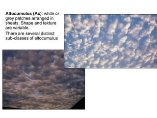
Educaterer India is an unique combination of passion driven into a hobby which makes an awesome profession. We carve the lives of enthusiastic candidates to a perfect professional who can impress upon the mindsets of the industry, while following the established traditions, can dare to set new standards to follow. We don't want you to be the part of the crowd, rather we like to make you the reason of the crowd.
Today's Effort For A Better Tomorrow
Clouds
What are clouds?
A cloud is a large collection of very tiny droplets of water or ice crystals. The droplets are so small and light that they can float in the air.
Why do clouds float?
A cloud is made up of liquid water droplets. A cloud forms when air is heated by the sun. As it rises, it slowly cools it reaches the saturation point and water condenses, forming a cloud. As long as the cloud and the air that its made of is warmer than the outside air around it, it floats!
There are 3 main types of clouds:
Cirrus or thin feathery clouds
Stratus or layered clouds
Cumulus or fluffy clouds
Cirrus Clouds
Are the most common of the
high clouds. They are composed of ice and are thin, wispy clouds blown in high winds into long streamers. Cirrus clouds are usually white and predict fair to pleasant weather. By watching the movement of cirrus clouds you can tell from which direction weather is approaching. When you see cirrus clouds, it usually indicates that a change in the weather will occur within 24 hours.
Stratus Clouds
are uniform grayish clouds that often cover the entire sky. They resemble fog that doesn't reach the ground. Light mist or drizzle sometimes falls out of these clouds.
Cumulus Clouds
are white, puffy clouds that look like pieces of floating cotton. Cumulus clouds are often called "fair-weather clouds". The base of each cloud is flat and the top of each cloud has rounded towers. When the top of the cumulus clouds resemble the head of a cauliflower, it is called cumulus congestus or towering cumulus. These clouds grow upward and they can develop into giant cumulonimbus clouds, which are thunderstorm clouds.
The Importance of Clouds
Clouds help regulate Earth's energy balance by reflecting and scattering solar radiation and by absorbing Earth's infrared energy.
Clouds are required for precipitation to occur and, hence are an essential part of the hydrologic cycle.
Clouds indicate what type of atmospheric processes are occurring (e.g., cumulus clouds indicate surface heating and atmospheric turbulence).
Clouds help redistribute extra heat from the equator toward the poles.
References
https://www.google.com/search?q=clouds&biw=1366&bih=624&source=lnms&tbm=isch&sa=X&ved=0ahUKEwixqOqjlu3NAhVHNpQKHbtGCE0Q_AUIBigB#imgrc=_
https://www.google.com/search?biw=1366&bih=624&tbm=isch&q=clouds+clipart&sa=X&ved=0ahUKEwir8paml-3NAhXGkJQKHSrFAPUQhyYIHQ&dpr=1#imgrc=WZWIVB52x_MJRM%3A
https://en.wikipedia.org/wiki/List_of_cloud_types
http://www.weatherwizkids.com/weather-clouds.htm
Material da Royal Meteorological Society. Trata-se de um "disco" que ajuda na identificação dos tipos de nuvens. Mais informações nesse post: http://meteoropole.com.br/2014/01/experiencia-13-circulo-de-nuvens/
1. UCHI (RUMAH)
Uchi ni ima to heya to daidokoro to toire ga arimasu. Ima wa heya no mae ni arimasu. Heya wa toire no shita ni arimasu . Toire wa daidokoro no tonari ni arimasu . Uchi ni heya ga mittsu arimasu. Watashi no uchi wa ooki kute hiro kute kirei desu
(Di rumah saya ada ruang tamu, kamar, dapur, toilet. Ruang tamu ada di depan kamar . Kamar ada dibawah toilet . Toilet ada di di samping dapur . Saya memiliki 3 kamar.Rumah saya besar, luas, dan cantik).
2. DAIDOKORO (DAPUR)
Daidokoro ni reizouko to teburu to oven to koppu to chawan to booru to supun to zasshi to satoo to kona to karenda to dana ga arimasu. Daidokoro ni supun ga futatsu arimasu . Chawam to booru to zasshi wa teburu no ue ni arimasu. . Daidokoro wa saisa kute semai desu.
(Di ruang tamu ada naga . Naga sedang meminum kopi . Diruang tamu ada kulkas, kursi dan meja sepasang, oven, gelas,cangkir, mangkok, sendok , majalah, gula , tepung ,kalender, dan Lemari . Ada 2 sendok . Cangkir,mangkok , majalah ada diatas meja. Dapur kecil dan sempit)
3. IMA (RUANG TAMU)
Ima ni sofa to kagami to makura to sashin to akari to kabin to hon to karpet to shashin ga arimasu . Ima ni terebi ga arimasen . Ima ni sofa ga mittsu to kabin ga futatsu to shashin ga mittsu to makura ga yattsu arimasu . kabin wa teburu no ue to yuka no ue ni arimasu. Nooto wa teburu no naka ni arimasu . akari wa teburu no ue ni arimasu . Watashi no ima wa ooki kute hiro kute kirei de akarui desu .
(Di ruang tamu ada sofa, kaca,bantal,lukisan, lampu, vas bunga, buku, karpet,foto. Di ruang tamu tidak ada TV. Ada 3 sofa, 2 vas bunga, 3 foto, 8 bantal. Vas bunga ada diatas meja sepasang dan di atas lantai . Buku ada diantara meja. Lampu ada diatas meja sepasang . Ruang tamu besar,luas, cantik,terang ).
4. HEYA (KAMAR)
Heya ni gorden to sofa to okurimono to ningyoo to beddo to makura to kamu to sashin to tsuque to kabin to karpet to akari to foto ga arimasu . Heya ni eakon ga arimasen. Heyaa ni ningyoo ga futatsu to makura ga mutsu to kabin ga futatsu to sashin ga mittsu arimasu . okurimono to ningyoo wa sofa no mae ni arimasu . Watashi no heya wa ooki kute hiro kute kirei de akarui desu .
(di kamar ada gorden sofa Kado boneka tempt tidur bantal selimut lukisan meja belajar, vas bunga ,karpet, lampu, foto. Di kamar tidak ada AC. Di kamar Ada 2 boneka,6 bantal,2 vas bunga,3 lukisan. Kado dan boneka ada di depan sofa. Kamar besar,luas, cantik,terang )
Kehidupan Perekonomian Amerika SerikatAlfi Jauharo
Amerika Serikat menerapkan sistem ekonomi kapitalis campuran . Perusahaan diperbolehkan untuk beroperasi di pasar bebas dan terbuka, dan individu-individu diharapkan mampu berusaha dengan inisiatif mereka sendiri untuk membangun keamanan stabilitas ekonomi mereka. Perusahaan menentukan apa yang akan mereka produksi dan harga untuk barang dan jasa mereka sementara pembeli menentukan apa yang akan mereka beli dengan harga berapa. Dalam hal ini pemerintah tentu saja tetap ikut campur dalam penentuan kebijakan ekonomi Amerika Serikat .
JMeter webinar - integration with InfluxDB and GrafanaRTTS
Watch this recorded webinar about real-time monitoring of application performance. See how to integrate Apache JMeter, the open-source leader in performance testing, with InfluxDB, the open-source time-series database, and Grafana, the open-source analytics and visualization application.
In this webinar, we will review the benefits of leveraging InfluxDB and Grafana when executing load tests and demonstrate how these tools are used to visualize performance metrics.
Length: 30 minutes
Session Overview
-------------------------------------------
During this webinar, we will cover the following topics while demonstrating the integrations of JMeter, InfluxDB and Grafana:
- What out-of-the-box solutions are available for real-time monitoring JMeter tests?
- What are the benefits of integrating InfluxDB and Grafana into the load testing stack?
- Which features are provided by Grafana?
- Demonstration of InfluxDB and Grafana using a practice web application
To view the webinar recording, go to:
https://www.rttsweb.com/jmeter-integration-webinar
Elevating Tactical DDD Patterns Through Object CalisthenicsDorra BARTAGUIZ
After immersing yourself in the blue book and its red counterpart, attending DDD-focused conferences, and applying tactical patterns, you're left with a crucial question: How do I ensure my design is effective? Tactical patterns within Domain-Driven Design (DDD) serve as guiding principles for creating clear and manageable domain models. However, achieving success with these patterns requires additional guidance. Interestingly, we've observed that a set of constraints initially designed for training purposes remarkably aligns with effective pattern implementation, offering a more ‘mechanical’ approach. Let's explore together how Object Calisthenics can elevate the design of your tactical DDD patterns, offering concrete help for those venturing into DDD for the first time!
State of ICS and IoT Cyber Threat Landscape Report 2024 previewPrayukth K V
The IoT and OT threat landscape report has been prepared by the Threat Research Team at Sectrio using data from Sectrio, cyber threat intelligence farming facilities spread across over 85 cities around the world. In addition, Sectrio also runs AI-based advanced threat and payload engagement facilities that serve as sinks to attract and engage sophisticated threat actors, and newer malware including new variants and latent threats that are at an earlier stage of development.
The latest edition of the OT/ICS and IoT security Threat Landscape Report 2024 also covers:
State of global ICS asset and network exposure
Sectoral targets and attacks as well as the cost of ransom
Global APT activity, AI usage, actor and tactic profiles, and implications
Rise in volumes of AI-powered cyberattacks
Major cyber events in 2024
Malware and malicious payload trends
Cyberattack types and targets
Vulnerability exploit attempts on CVEs
Attacks on counties – USA
Expansion of bot farms – how, where, and why
In-depth analysis of the cyber threat landscape across North America, South America, Europe, APAC, and the Middle East
Why are attacks on smart factories rising?
Cyber risk predictions
Axis of attacks – Europe
Systemic attacks in the Middle East
Download the full report from here:
https://sectrio.com/resources/ot-threat-landscape-reports/sectrio-releases-ot-ics-and-iot-security-threat-landscape-report-2024/
Generating a custom Ruby SDK for your web service or Rails API using Smithyg2nightmarescribd
Have you ever wanted a Ruby client API to communicate with your web service? Smithy is a protocol-agnostic language for defining services and SDKs. Smithy Ruby is an implementation of Smithy that generates a Ruby SDK using a Smithy model. In this talk, we will explore Smithy and Smithy Ruby to learn how to generate custom feature-rich SDKs that can communicate with any web service, such as a Rails JSON API.
UiPath Test Automation using UiPath Test Suite series, part 4DianaGray10
Welcome to UiPath Test Automation using UiPath Test Suite series part 4. In this session, we will cover Test Manager overview along with SAP heatmap.
The UiPath Test Manager overview with SAP heatmap webinar offers a concise yet comprehensive exploration of the role of a Test Manager within SAP environments, coupled with the utilization of heatmaps for effective testing strategies.
Participants will gain insights into the responsibilities, challenges, and best practices associated with test management in SAP projects. Additionally, the webinar delves into the significance of heatmaps as a visual aid for identifying testing priorities, areas of risk, and resource allocation within SAP landscapes. Through this session, attendees can expect to enhance their understanding of test management principles while learning practical approaches to optimize testing processes in SAP environments using heatmap visualization techniques
What will you get from this session?
1. Insights into SAP testing best practices
2. Heatmap utilization for testing
3. Optimization of testing processes
4. Demo
Topics covered:
Execution from the test manager
Orchestrator execution result
Defect reporting
SAP heatmap example with demo
Speaker:
Deepak Rai, Automation Practice Lead, Boundaryless Group and UiPath MVP
Key Trends Shaping the Future of Infrastructure.pdfCheryl Hung
Keynote at DIGIT West Expo, Glasgow on 29 May 2024.
Cheryl Hung, ochery.com
Sr Director, Infrastructure Ecosystem, Arm.
The key trends across hardware, cloud and open-source; exploring how these areas are likely to mature and develop over the short and long-term, and then considering how organisations can position themselves to adapt and thrive.
Essentials of Automations: Optimizing FME Workflows with ParametersSafe Software
Are you looking to streamline your workflows and boost your projects’ efficiency? Do you find yourself searching for ways to add flexibility and control over your FME workflows? If so, you’re in the right place.
Join us for an insightful dive into the world of FME parameters, a critical element in optimizing workflow efficiency. This webinar marks the beginning of our three-part “Essentials of Automation” series. This first webinar is designed to equip you with the knowledge and skills to utilize parameters effectively: enhancing the flexibility, maintainability, and user control of your FME projects.
Here’s what you’ll gain:
- Essentials of FME Parameters: Understand the pivotal role of parameters, including Reader/Writer, Transformer, User, and FME Flow categories. Discover how they are the key to unlocking automation and optimization within your workflows.
- Practical Applications in FME Form: Delve into key user parameter types including choice, connections, and file URLs. Allow users to control how a workflow runs, making your workflows more reusable. Learn to import values and deliver the best user experience for your workflows while enhancing accuracy.
- Optimization Strategies in FME Flow: Explore the creation and strategic deployment of parameters in FME Flow, including the use of deployment and geometry parameters, to maximize workflow efficiency.
- Pro Tips for Success: Gain insights on parameterizing connections and leveraging new features like Conditional Visibility for clarity and simplicity.
We’ll wrap up with a glimpse into future webinars, followed by a Q&A session to address your specific questions surrounding this topic.
Don’t miss this opportunity to elevate your FME expertise and drive your projects to new heights of efficiency.
Epistemic Interaction - tuning interfaces to provide information for AI supportAlan Dix
Paper presented at SYNERGY workshop at AVI 2024, Genoa, Italy. 3rd June 2024
https://alandix.com/academic/papers/synergy2024-epistemic/
As machine learning integrates deeper into human-computer interactions, the concept of epistemic interaction emerges, aiming to refine these interactions to enhance system adaptability. This approach encourages minor, intentional adjustments in user behaviour to enrich the data available for system learning. This paper introduces epistemic interaction within the context of human-system communication, illustrating how deliberate interaction design can improve system understanding and adaptation. Through concrete examples, we demonstrate the potential of epistemic interaction to significantly advance human-computer interaction by leveraging intuitive human communication strategies to inform system design and functionality, offering a novel pathway for enriching user-system engagements.
Neuro-symbolic is not enough, we need neuro-*semantic*Frank van Harmelen
Neuro-symbolic (NeSy) AI is on the rise. However, simply machine learning on just any symbolic structure is not sufficient to really harvest the gains of NeSy. These will only be gained when the symbolic structures have an actual semantics. I give an operational definition of semantics as “predictable inference”.
All of this illustrated with link prediction over knowledge graphs, but the argument is general.
Slack (or Teams) Automation for Bonterra Impact Management (fka Social Soluti...Jeffrey Haguewood
Sidekick Solutions uses Bonterra Impact Management (fka Social Solutions Apricot) and automation solutions to integrate data for business workflows.
We believe integration and automation are essential to user experience and the promise of efficient work through technology. Automation is the critical ingredient to realizing that full vision. We develop integration products and services for Bonterra Case Management software to support the deployment of automations for a variety of use cases.
This video focuses on the notifications, alerts, and approval requests using Slack for Bonterra Impact Management. The solutions covered in this webinar can also be deployed for Microsoft Teams.
Interested in deploying notification automations for Bonterra Impact Management? Contact us at sales@sidekicksolutionsllc.com to discuss next steps.
Encryption in Microsoft 365 - ExpertsLive Netherlands 2024Albert Hoitingh
In this session I delve into the encryption technology used in Microsoft 365 and Microsoft Purview. Including the concepts of Customer Key and Double Key Encryption.
5. Cloud Classification
Four latin terms form the basis for the naming of clouds:
– Cirrus : fibrous or hair-like
– Cumulus : a heap or pile
– Stratus : a horizontal sheet or layer
– Nimbus : rain-bearing
The prefix Alto is used to indicate medium altitude
clouds.
Terms, and basic classifications first proposed by Luke Howard in 1803.
http://ww2010.atmos.uiuc.edu/(Gh)/guides/mtr/cld/cldtyp/home.rxml - good online guide
6. Cloud types
Name of
cloud types
Conventional
symbols
Average
heights
Notes
Stratus St 800m High fogs
Nimbostratus Ns 1000m
Heavy
showers
Stratocumulus Sc 1500m
Altocumulus Ac 3500m
Altostratus As 4000m
Cirrocumulus Cc 7000m
Cirrostratus Cs 8000m
Forming
halos
Cirrus Ci 9000m
Not hiding
the sun
Cumulus Cu 18000m
Clouds
formed by
ascent of air
Cumulonimbus Cb 20000m
Clouds
formed by
ascent of air
Low clouds
(average higher level
2000m; average lower
level near the soil)
Average clouds
(average higher level
6000m; average lower
level 2000m)
High clouds
(average lower level
6000m)
Vertical clouds
7. High Level:
– Cloud base above 6000m
– Are all forms of cirrus (ice clouds)
Medium Level:
– Cloud base
2000-6000m
Low level:
– Cloud base below 2000m (within boundary layer)
8. High-Level Clouds
Cirrus (Ci): White, delicate, fibrous in
appearance. Forms in patches or narrow
bands. May for comma-shaped streaks or
“mare’s tails” (cirrus uncinus)
Cirrus clouds are formed entirely
of ice crystals. These grow and
evaporate slowly, leading to soft
edges to clouds.
9. Cirrostratus (Cs):
Thin, transparent sheet or veil;
sun clearly visible & casting
shadows at surface. A halo may
be seen around the sun (or
moon). Sheets of cirrostratus
may cover entire sky, and be up
to several 1000m deep.
10. Cirrocumulus (Cc): Thin white
patch or sheet of cloud; appears
dappled or rippled. Dappling
results from convective
overturning within the cloud,
ripples from gravity waves.
Aircraft contrails: condensation
from aircraft exhaust. May
dissipate quickly, or be very long-
lived depending on conditions.
11. Medium-Level Clouds
Altostratus (As): A greyish
sheet of cloud, may be fibrous
or uniform in appearance.
Thin enough in parts to make
out the sun, but no halo.
12. Altocumulus (Ac): white or
grey patches arranged in
sheets. Shape and texture
are variable.
There are several distinct
sub-classes of altocumulus
13. Altocumulus lenticularis (Ac len):
white or grey lenticular (lens
shaped) clouds formed by the lifting
of air over a topographic barrier.
14. Altocumulus castellanus
(Ac cas): white or grey, broken
cumulus-like clouds; upper part
appearing castle-like.
Sometimes arranged in lines.
15. Altocumulus undulatus (Ac und):
white or grey patches or sheets of
cloud with an undulating or rippled
appearance.
16. Low-Level Clouds
Cumulus (Cu): Brilliant white to grey,
dense detached clouds. Forms clumped
or heaped (cauliflower-like) shapes,
usually with sharp outlines and flat base.
Field of Cu often have bases all at same
(lifting condensation) level.
17. Cumulus humilis (Cu hum):
small cumulus, of limited
vertical extent, may have a
flattened appearance. Also
called fair-weather cumulus
20. Pileus : cap clouds that form above large cumulus as the
upward motion of the convective cloud distorts the layer of air
above (pileus is latin for skull-cap)
21.
22. Cumulonimbus (Cb) : huge towering cloud, dark base and white
sides. Associated with heavy rain, thunderstorms, and hail. Frequently
has an anvil shaped top.
23. mammatus : smooth, rounded shapes sometimes formed on
the underside of cumulonimbus; they result from downdrafts
within the cloud.
27. Stratocumulus with virga – hair-like strands of falling
rain, which evaporate below cloud before reaching the surface.
28. Stratus (St) : grey featureless layer of cloud with a uniform base.
Often associated with drizzle or snow.
29. Nimbostratus (Ns) : Dark grey,
featureless, thick layer of cloud.
Associated with prolonged
precipitation. Commonly forms
in frontal systems
30. Precipitation
• Cloud droplets require a condensation nuclei on which to
form; growth then occurs by deposition of water molecules
from vapour.
– Growth is limited by local supersaturation of the vapour
– Growth rate decreases as droplet size increases
• Cloud droplets are typically 10 to 30 m in diameter.
Growth/evaporation can occur within a few 10s of seconds.
• Rain drops are typically 0.5 to 5 mm in diameter, growth from
the vapour would take several hours – longer than the lifetime
of typical convective clouds.
31. • In order to grow into rain drops, cloud droplets must grow by
coalescence
– Larger droplets fall faster than small ones, and can collide with them
– The process by which a sufficient number of large enough droplets is
generated remains a topic of active research
• Ice crystals provide a more efficient process
– Saturation vapour pressure over ice is less than that over water ice
crystals grow at expense of water droplets
– If ice crystal touches a droplet, the droplet freezes
– Once large enough, ice crystals – or clumps of crystals – fall past
droplets and collect them. Rapid growth of soft hail pellet (graupel) by
riming.
– Graupel falls from cloud, melting before reaching the surface as rain
32. Cloud Radiative Effects
• Clouds play an important controlling role in the
global radiation budget.
– Reflection of incoming solar (short-wave) radiation
– Absorption of both solar and thermal infra red (long-wave)
radiation (incoming & outgoing)
– Emission of infra red radiation (up and down)
• The altitude, type, and thickness of cloud, along with
that of clouds above & below determines whether
the local net effect is to warm or cool the air &
surface below.
33. Vertical Transport
• Deep convective clouds play a major role in
mixing boundary layer air – along with
moisture, aerosol particles, and gases (both
natural and man-made pollutants) – up into
the free-troposphere.
34. Chemistry
• Clouds provide an environment within which
aqueous phase chemical reactions can take place
within the atmosphere
• Aerosol particles can be substantially modified within
clouds
– Aqueous phase reactions with gases dissolved in droplets
– Coalescence of droplets brings multiple aerosol particles
together
• Chemically different aerosol may react
• On evaporation of droplet, a single aerosol particle is formed,
containing material from all contributing droplets