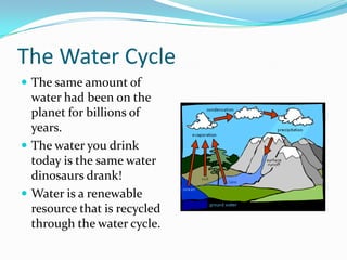
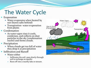
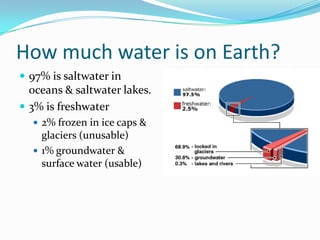
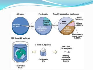
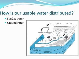
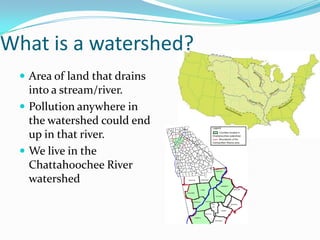
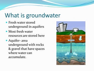
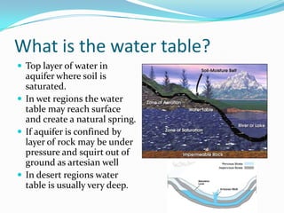
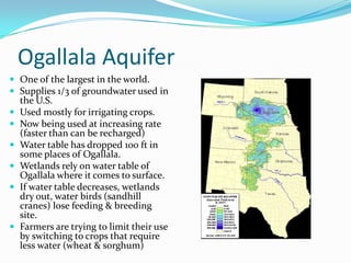
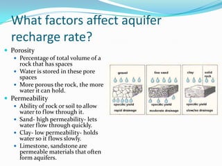
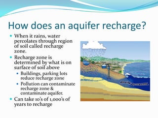
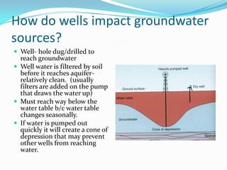
Chapter 11, Section 1: Water Resources
Standards: SEV5e
The Water Cycle
 The same amount of
water had been on the
planet for billions of
years.
 The water you drink
today is the same water
dinosaurs drank!
 Water is a renewable
resource that is recycled
through the water cycle.
The Water Cycle
 Evaporation
 Water evaporates when heated by
sun (leaves salts behind)
 Transpiration- water evaporation
from plants
 Condensation
 As water vapor rises it cools,
condenses, and collects on dust
particles in the sky (condensation
nuclei) and forms clouds.
 Precipitation
 When clouds get too full of water
they drop it as precipitation
 Infiltration and Runoff
 Water either
 Infiltrates the soil- pass slowly through
soil to recharge an aquifer
 Runs off into a nearby lake or stream.
How much water is on Earth?
 97% is saltwater in
oceans & saltwater lakes.
 3% is freshwater
 2% frozen in ice caps &
glaciers (unusable)
 1% groundwater &
surface water (usable)
How is our usable water distributed?
 Surface water
 Groundwater
What is surface water?
 Fresh water above
ground.
 Important for
 Drinking water
 Transportation of goods
via ships
 Irrigation
 Aquaculture
 Power for industry
What are the types of Surface Water?
 Rivers & streams
 Fast moving
 Cold, highly oxygenated
 Insect larvae, trout, long narrow
plants, algae
 Lakes & ponds
 Slow moving
 Warm, less oxygenated
 Bass, catfish, cattails, leeches
 Wetlands
 Covered with water most of the
year
 Absorb and slow water flow
 Filter pollutants & sediment
 Provide breeding ground for
water birds, shellfish, fish
What is a river system?
 Streams form in higher
elevations from rainfall or
melting snow.
 As they move downhill they
combine with other streams
to form rivers.
 Streams that feed rivers are
called tributaries.
 This interconnection of
streams to form rivers is the
river system
 Ex: McEachern creek flows
to Noses Creek to Sweetwater
Creek to Chattahoochee
River
Lake Lanier
West Point
Lake
Walter F.
George
Lake
Lake
Seminole
Apalachicola
River
Flint River
Chattahoochee
River
What is a watershed?
 Area of land that drains
into a stream/river.
 Pollution anywhere in
the watershed could end
up in that river.
 We live in the
Chattahoochee River
watershed
What is groundwater
 Fresh water stored
underground in aquifers
 Most fresh water
resources are stored here
 Aquifer- area
underground with rocks
& gravel that have spaces
where water can
accumulate.
What is the water table?
 Top layer of water in
aquifer where soil is
saturated.
 In wet regions the water
table may reach surface
and create a natural spring.
 If aquifer is confined by
layer of rock may be under
pressure and squirt out of
ground as artesian well
 In desert regions water
table is usually very deep.
Ogallala Aquifer
 One of the largest in the world.
 Supplies 1/3 of groundwater used in
the U.S.
 Used mostly for irrigating crops.
 Now being used at increasing rate
(faster than can be recharged)
 Water table has dropped 100 ft in
some places of Ogallala.
 Wetlands rely on water table of
Ogallala where it comes to surface.
 If water table decreases, wetlands
dry out, water birds (sandhill
cranes) lose feeding & breeding
site.
 Farmers are trying to limit their use
by switching to crops that require
less water (wheat & sorghum)
What factors affect aquifer
recharge rate?
 Porosity
 Percentage of total volume of a
rock that has spaces
 Water is stored in these pore
spaces
 More porous the rock, the more
water it can hold.
 Permeability
 Ability of rock or soil to allow
water to flow through it.
 Sand- high permeability- lets
water flow through quickly.
 Clay- low permeability- holds
water so it flows slowly.
 Limestone, sandstone are
permeable materials that often
form aquifers.
How does an aquifer recharge?
 When it rains, water
percolates through region
of soil called recharge
zone.
 Recharge zone is
determined by what is on
surface of soil above
 Buildings, parking lots
reduce recharge zone
 Pollution can contaminate
recharge zone &
contaminate aquifer.
 Can take 10’s of 1,000’s of
years to recharge
How do wells impact groundwater
sources?
 Well- hole dug/drilled to
reach groundwater
 Well water is filtered by soil
before it reaches aquifer-
relatively clean. (usually
filters are added on the pump
that draws the water up)
 Must reach way below the
water table b/c water table
changes seasonally.
 If water is pumped out
quickly it will create a cone of
depression that may prevent
other wells from reaching
water.
You should be able to…
 Describe the distribution of water on Earth. Where is
most of the freshwater located?
 Explain why fresh water is considered a limited
resource.
 Explain why pollution in a watershed poses a potential
threat to the river system that flows through it.
 Describe how water travels through rocks and soil.

Unit 7 ch 11 s1 water resources

  • 1.
    Chapter 11, Section1: Water Resources Standards: SEV5e
  • 2.
    The Water Cycle The same amount of water had been on the planet for billions of years.  The water you drink today is the same water dinosaurs drank!  Water is a renewable resource that is recycled through the water cycle.
  • 3.
    The Water Cycle Evaporation  Water evaporates when heated by sun (leaves salts behind)  Transpiration- water evaporation from plants  Condensation  As water vapor rises it cools, condenses, and collects on dust particles in the sky (condensation nuclei) and forms clouds.  Precipitation  When clouds get too full of water they drop it as precipitation  Infiltration and Runoff  Water either  Infiltrates the soil- pass slowly through soil to recharge an aquifer  Runs off into a nearby lake or stream.
  • 4.
    How much wateris on Earth?  97% is saltwater in oceans & saltwater lakes.  3% is freshwater  2% frozen in ice caps & glaciers (unusable)  1% groundwater & surface water (usable)
  • 6.
    How is ourusable water distributed?  Surface water  Groundwater
  • 7.
    What is surfacewater?  Fresh water above ground.  Important for  Drinking water  Transportation of goods via ships  Irrigation  Aquaculture  Power for industry
  • 8.
    What are thetypes of Surface Water?  Rivers & streams  Fast moving  Cold, highly oxygenated  Insect larvae, trout, long narrow plants, algae  Lakes & ponds  Slow moving  Warm, less oxygenated  Bass, catfish, cattails, leeches  Wetlands  Covered with water most of the year  Absorb and slow water flow  Filter pollutants & sediment  Provide breeding ground for water birds, shellfish, fish
  • 9.
    What is ariver system?  Streams form in higher elevations from rainfall or melting snow.  As they move downhill they combine with other streams to form rivers.  Streams that feed rivers are called tributaries.  This interconnection of streams to form rivers is the river system  Ex: McEachern creek flows to Noses Creek to Sweetwater Creek to Chattahoochee River
  • 10.
    Lake Lanier West Point Lake WalterF. George Lake Lake Seminole Apalachicola River Flint River Chattahoochee River
  • 11.
    What is awatershed?  Area of land that drains into a stream/river.  Pollution anywhere in the watershed could end up in that river.  We live in the Chattahoochee River watershed
  • 12.
    What is groundwater Fresh water stored underground in aquifers  Most fresh water resources are stored here  Aquifer- area underground with rocks & gravel that have spaces where water can accumulate.
  • 13.
    What is thewater table?  Top layer of water in aquifer where soil is saturated.  In wet regions the water table may reach surface and create a natural spring.  If aquifer is confined by layer of rock may be under pressure and squirt out of ground as artesian well  In desert regions water table is usually very deep.
  • 14.
    Ogallala Aquifer  Oneof the largest in the world.  Supplies 1/3 of groundwater used in the U.S.  Used mostly for irrigating crops.  Now being used at increasing rate (faster than can be recharged)  Water table has dropped 100 ft in some places of Ogallala.  Wetlands rely on water table of Ogallala where it comes to surface.  If water table decreases, wetlands dry out, water birds (sandhill cranes) lose feeding & breeding site.  Farmers are trying to limit their use by switching to crops that require less water (wheat & sorghum)
  • 15.
    What factors affectaquifer recharge rate?  Porosity  Percentage of total volume of a rock that has spaces  Water is stored in these pore spaces  More porous the rock, the more water it can hold.  Permeability  Ability of rock or soil to allow water to flow through it.  Sand- high permeability- lets water flow through quickly.  Clay- low permeability- holds water so it flows slowly.  Limestone, sandstone are permeable materials that often form aquifers.
  • 16.
    How does anaquifer recharge?  When it rains, water percolates through region of soil called recharge zone.  Recharge zone is determined by what is on surface of soil above  Buildings, parking lots reduce recharge zone  Pollution can contaminate recharge zone & contaminate aquifer.  Can take 10’s of 1,000’s of years to recharge
  • 17.
    How do wellsimpact groundwater sources?  Well- hole dug/drilled to reach groundwater  Well water is filtered by soil before it reaches aquifer- relatively clean. (usually filters are added on the pump that draws the water up)  Must reach way below the water table b/c water table changes seasonally.  If water is pumped out quickly it will create a cone of depression that may prevent other wells from reaching water.
  • 18.
    You should beable to…  Describe the distribution of water on Earth. Where is most of the freshwater located?  Explain why fresh water is considered a limited resource.  Explain why pollution in a watershed poses a potential threat to the river system that flows through it.  Describe how water travels through rocks and soil.