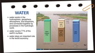
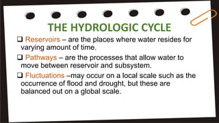
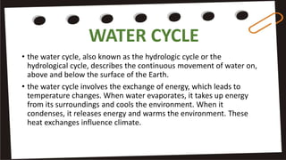
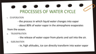
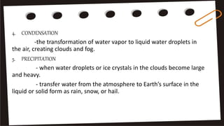
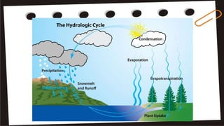
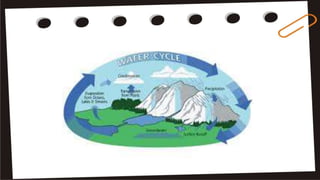
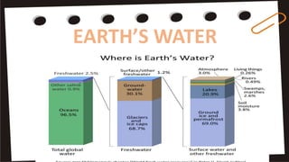
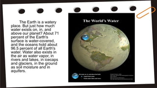
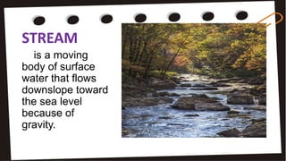
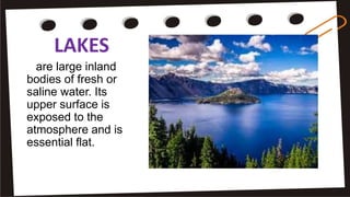
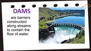
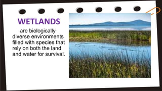
WATER
 water exists in the
hydrosphere, geosphere,
atmosphere, and biosphere,
and connected together by
processes in the hydrologic
cycle.
 water covers 71% of the
earth’s surface
 water plays an important role
in the world economy.
earth is the only planet where water in its liquid form
exists. In other planets, water occurs in the form of ice
vapor.
the earth’s subsystem containing the ocean, lakes,
streams, underground water, and snow and ice is the
hydrosphere.
 it occurs as water vapor in the atmosphere, as an
important constituent of the minerals in the geosphere,
and a fundamental component of living organisms in
the biosphere.
THE HYDROLOGIC CYCLE
• the hydrologic cycle begins with the evaporation of
water from the surface of the ocean. As moist air is
lifted, it cools and water vapor condenses to form
clouds. Moisture is transported around the globe until it
returns to the surface as precipitation.
• is the movement of water around earth’s surface and
its subsystem. The cycle consists of interconnected
pathways and reservoirs. Reservoirs are the places
where water resides for varying amount of time.
THE HYDROLOGIC CYCLE
 Reservoirs – are the places where water resides for
varying amount of time.
 Pathways – are the processes that allow water to
move between reservoir and subsystem.
 Fluctuations –may occur on a local scale such as the
occurrence of flood and drought, but these are
balanced out on a global scale.
WATER CYCLE
• the water cycle, also known as the hydrologic cycle or the
hydrological cycle, describes the continuous movement of water on,
above and below the surface of the Earth.
• the water cycle involves the exchange of energy, which leads to
temperature changes. When water evaporates, it takes up energy
from its surroundings and cools the environment. When it
condenses, it releases energy and warms the environment. These
heat exchanges influence climate.
PROCESSES OF WATER CYCLE
1. EVAPORATION
- the process in which liquid water changes into vapor
- about 80% of water vapor in the atmosphere evaporates
from the ocean.
2. TRANSPIRATION
- the release of water vapor from plants and soil into the air.
3. SUBLIMATION
- in, high altitudes, ice can directly transform into water vapor
4. CONDENSATION
-the transformation of water vapor to liquid water droplets in
the air, creating clouds and fog.
5. PRECIPITATION
- when water droplets or ice crystals in the clouds become large
and heavy.
- transfer water from the atmosphere to Earth’s surface in the
liquid or solid form as rain, snow, or hail.
EARTH’S WATER
The Earth is a watery
place. But just how much
water exists on, in, and
above our planet? About 71
percent of the Earth's
surface is water-covered,
and the oceans hold about
96.5 percent of all Earth's
water. Water also exists in
the air as water vapor, in
rivers and lakes, in icecaps
and glaciers, in the ground
as soil moisture and in
aquifers.
RESIDENCE TIME
- is the average
length of time spent
by water molecule in
a reservoir, In large
reservoir the
residence time of
water is longer.
SALTWATER RESERVOIR
 an ocean is vast body of saline water. The saltiness of saltwater
is called salinity.
 the principal sources of the elements dissolved in seawater are
weathering and volcanic erruptions.
 weathering, or in situ disintergration of geologic materials,
releases soluble materials such as sodium, potassium, and sulfur.
 volcanic eruptions, both on land and submarine, contribute,
compounds through volcanic gases and hot springs.
FRESHWATER RESERVOIRS
- most of the freshwater on Earth is stored in glaciers situated in
inaccessible areas such as the Polar Regions and high mountains.
The readily available freshwater sources are the surface water
reservoir and groundwater reservoir.
Glaciers and Ice Sheets
- glacier is a permanent body of ice, which consists largely of
recrystallized snow. While an ice sheet is a mass of glacial land ice
extending more than 50,000 km².
Permafrost
- a soil, rock, or sediment that is frozen for more than two
consecutive years. The frozen ground varies in thickness from a
few meters to about 150 meters. The upper 30 cm to 100 cm of soil
thaws during summer and refreezes during winter. Most of the
permafrost is found in Polar Regions, although they may exist in
high-altitude regions.
SURFACE WATER RESERVOIRS
- surface water include the streams, lakes, and
wetlands where water from rainfall, melting, snow
and ice, and groundwater flows. They represent
0.3% of Earth’s total water resource. This resource
is harnessed for irrigation, recreation, transport,
fishing, drinking, and hydropower.
STREAM
is a moving
body of surface
water that flows
downslope toward
the sea level
because of
gravity.
LAKES
are large inland
bodies of fresh or
saline water. Its
upper surface is
exposed to the
atmosphere and is
essential flat.
PONDS
-are
small and
shallow
lakes.
DAMS
are barriers
constructed
along streams
to contain the
flow of water.
WETLANDS
are biologically
diverse environments
filled with species that
rely on both the land
and water for survival.
THE TYPES OF WETLANDS INCLUDE:
1. Marsh
- is a shallow wetland around lakes, streams, and oceans
where grasses and reeds are dominant vegetation.
2. Swamp
- is a wetland with lush trees and vegetation found in low-lying
areas beside slow moving rivers.
3. Estuary
- is a partly enclosed coastal body of water where freshwater
from stream meets the saltwater from the sea.
FLOOD
- is a natural event wherein an area that is usually dry is
submerged under water. Flooding may occur as an overflow of
water from water bodies, such as a river, lake, or ocean, in which
the water overtops or breaks levees, resulting in some of that
water escaping its usual boundaries, or it may occur due to an
accumulation of rainwater on saturated ground in an areal flood.
FLUVIAL OR RIVERINE FLOOD
- occurs when a stream’s discharge is greater than the capacity
of the channel, causing the stream to overflow. It occurs when
excessive rainfall over an extended period of time causes a river
to exceed its capacity. It can also be caused by heavy snow melt
and ice jams. The damage from a river flood can be widespread
as the overflow affects smaller rivers downstream, often causing
dams and dikes to break and swamp nearby areas.
FLASHFLOODS
- characterized by intense, high-velocity torrent of water that
occurs in an existing river channel with little to no notice. It may
be caused by heavy rain associated with a severe thunderstorm,
hurricane, tropical storm, or meltwater from ice or snow flowing
over ice sheets or snowfields.
COASTAL FLOODING
- occurs when water overwhelms in low-lying areas along the
coasts, usually due to severe weather conditions. The extent of
coastal flooding is a function of the elevation inland flood waters
penetrate which is controlled by the topography of the coastal
land exposed to flooding.
PLUVIAL OR SURFACE WATER FLOOD
- occurs when heavy rainfall creates a flood event independent
of an overflowing stream. One of the most common
misconceptions about flood risk is that one must be located near
a body of water to be at risk. Pluvial flooding debunks that myth,
as it can happen in any urban area — even higher elevation
areas that lie above coastal and river floodplains.
GROUNDWATER
 is the water present beneath Earth's surface in soil pore spaces and
in the fractures of rock formations. A unit of rock or an
unconsolidated deposit is called an aquifer when it can yield a
usable quantity of water. The depth at which soil pore spaces or
fractures and voids in rock become completely saturated with water
is called the water table. Groundwater is recharged from the surface;
it may discharge from the surface naturally at springs and seeps,
and can form oases or wetlands. Groundwater is also often
withdrawn for agricultural, municipal, and industrial use by
constructing and operating extraction wells. The study of the
distribution and movement of groundwater is hydrogeology, also
called groundwater hydrology.
GROUNDWATER PROFILE
- when a well is excavated in the ground, the first
layer encountered is the moist soil layer on the
surface. Beneath this is a zone in which the
spaces between the particles are filled mainly with
air. This is called the zone of aeration is the zone
of saturation.
UNCONFINED AQUIFER
 an aquifer in which groundwater is free to
rise to its natural level.
 water is open to the atmosphere through
pores in the soil and rock above the aquifer.
CONFINED AQUIFER
- the water is trapped and held down by
pressure between impermeable rocks
called aquiclude.
ARTESIAN WELL
- a perched water table or aquifer occurs
when there is a localized aquiclude above the
main water table. It stores a relatively small
amount of groundwater.
RECHARGE ZONE
 the land area where water enters the ground and
replenish the groundwater.
 in confined aquifers, the recharge zone is limited only
in areas where the aquifers is exposed to the surface
 in inconfined quifers, this is basically the whole
drainage basin or watershed.
DISCHARGE ZONE
 is the area where the groundwater flows out of
the aquifer and onto land surface or even in
submarine environment.
 a well in which groundwater is pumped out is
also a discharge zone.
SPRINGS
 when groundwater
energy as to the ground
surface, a spring is
created.
 it is usually appears in
places where there is a
decrease in permeability
of underlying material,
such as pressure of an
aquiclude below an
aquifer.
HENRY DARCY
- was a French engineer who made
several important contributions to
hydraulics including Darcy’s law for
flow in porous media. Darcy's law is
an equation that describes the flow
of a fluid through a porous medium.
The law was formulated by Henry
Darcy based on results of
experiments on the flow of water
through beds of sand, forming the
basis of hydrogeology, a branch of
earth sciences.
WATER AS A RESOURCE
Activities Affecting the Quality of Water
The human activities affecting water resources include the
following:
1. Population growth, particularly in water-short regions.
2. Movement of large number of people from the countryside to
towns and cities.
3. Demands for greater food security and higher living
standards.
4. Increased competiton between different uses of water
resources.
5. Pollution from factorie, cities, and farmlands.
SEDIMENTATION
- the degradation of ecosystems is one of the serious
threats, which occur due to changes in landscapes-
deforestation, conversion of natural landscapes into farm
or residential areas, urban growth, road-building, and
surface mining. These activities have led to too much soil
and sediments delivered to streams.
ACID MINE DRAINAGE
- mining of certain metals have also caused
surface water to become acidic, producing a
discharge.
WATER RESOURCE MANAGEMENT AND CONSERVATION
- Water conservation and management emphasizes water quality
protection, a growing area of employment and environmental concern.
Water conservation and management encompasses the policies,
strategies and activities made to manage water as a sustainable
resource, to protect the water environment, and to meet current and
future human demand. Population, household size, and growth and
affluence all affect how much water is used. Factors such as climate
change will increase pressures on natural water resources especially in
industrial and agriculture.
In the Philippines, several laws and regulations have been enacted for
the protection, conservation, and management of freshwater resources
1. Presidential Decree (PD) No. 424 of 1974 created the National
Water Resources Council to coordinate and integrate water
resources development.
2. PD No. 1067 (1976) instituted the Water Code which consolidated
the laws governing the ownership, appropriation, utilization,
exploitation, development, conservation, and protection of the
water resources subject to regulation by the NWRC
3. Executive Order (EO) No. 22 of 1995 established the Presidential
Committee on Water Conservation and Demand Management
which was tasked to prepare a nationwide Water Conservation
Plan.
4. Republic Act (RA) No. 8041 or the National Water Crisis Act of 1995
addressed the country’s water problems through an integrated
water management program and development of new water
resources and conservation of identified watersheds, among the
provisions.
5. The Philippine Clean Water Act of 2004 also provided a
comprehensive water quality management.

Eath sci (compuesto, dimabayao)

  • 2.
    WATER  water existsin the hydrosphere, geosphere, atmosphere, and biosphere, and connected together by processes in the hydrologic cycle.  water covers 71% of the earth’s surface  water plays an important role in the world economy.
  • 3.
    earth is theonly planet where water in its liquid form exists. In other planets, water occurs in the form of ice vapor. the earth’s subsystem containing the ocean, lakes, streams, underground water, and snow and ice is the hydrosphere.  it occurs as water vapor in the atmosphere, as an important constituent of the minerals in the geosphere, and a fundamental component of living organisms in the biosphere.
  • 4.
    THE HYDROLOGIC CYCLE •the hydrologic cycle begins with the evaporation of water from the surface of the ocean. As moist air is lifted, it cools and water vapor condenses to form clouds. Moisture is transported around the globe until it returns to the surface as precipitation. • is the movement of water around earth’s surface and its subsystem. The cycle consists of interconnected pathways and reservoirs. Reservoirs are the places where water resides for varying amount of time.
  • 5.
    THE HYDROLOGIC CYCLE Reservoirs – are the places where water resides for varying amount of time.  Pathways – are the processes that allow water to move between reservoir and subsystem.  Fluctuations –may occur on a local scale such as the occurrence of flood and drought, but these are balanced out on a global scale.
  • 6.
    WATER CYCLE • thewater cycle, also known as the hydrologic cycle or the hydrological cycle, describes the continuous movement of water on, above and below the surface of the Earth. • the water cycle involves the exchange of energy, which leads to temperature changes. When water evaporates, it takes up energy from its surroundings and cools the environment. When it condenses, it releases energy and warms the environment. These heat exchanges influence climate.
  • 7.
    PROCESSES OF WATERCYCLE 1. EVAPORATION - the process in which liquid water changes into vapor - about 80% of water vapor in the atmosphere evaporates from the ocean. 2. TRANSPIRATION - the release of water vapor from plants and soil into the air. 3. SUBLIMATION - in, high altitudes, ice can directly transform into water vapor
  • 8.
    4. CONDENSATION -the transformationof water vapor to liquid water droplets in the air, creating clouds and fog. 5. PRECIPITATION - when water droplets or ice crystals in the clouds become large and heavy. - transfer water from the atmosphere to Earth’s surface in the liquid or solid form as rain, snow, or hail.
  • 11.
  • 12.
    The Earth isa watery place. But just how much water exists on, in, and above our planet? About 71 percent of the Earth's surface is water-covered, and the oceans hold about 96.5 percent of all Earth's water. Water also exists in the air as water vapor, in rivers and lakes, in icecaps and glaciers, in the ground as soil moisture and in aquifers.
  • 13.
    RESIDENCE TIME - isthe average length of time spent by water molecule in a reservoir, In large reservoir the residence time of water is longer.
  • 14.
    SALTWATER RESERVOIR  anocean is vast body of saline water. The saltiness of saltwater is called salinity.  the principal sources of the elements dissolved in seawater are weathering and volcanic erruptions.  weathering, or in situ disintergration of geologic materials, releases soluble materials such as sodium, potassium, and sulfur.  volcanic eruptions, both on land and submarine, contribute, compounds through volcanic gases and hot springs.
  • 15.
    FRESHWATER RESERVOIRS - mostof the freshwater on Earth is stored in glaciers situated in inaccessible areas such as the Polar Regions and high mountains. The readily available freshwater sources are the surface water reservoir and groundwater reservoir. Glaciers and Ice Sheets - glacier is a permanent body of ice, which consists largely of recrystallized snow. While an ice sheet is a mass of glacial land ice extending more than 50,000 km².
  • 16.
    Permafrost - a soil,rock, or sediment that is frozen for more than two consecutive years. The frozen ground varies in thickness from a few meters to about 150 meters. The upper 30 cm to 100 cm of soil thaws during summer and refreezes during winter. Most of the permafrost is found in Polar Regions, although they may exist in high-altitude regions.
  • 17.
    SURFACE WATER RESERVOIRS -surface water include the streams, lakes, and wetlands where water from rainfall, melting, snow and ice, and groundwater flows. They represent 0.3% of Earth’s total water resource. This resource is harnessed for irrigation, recreation, transport, fishing, drinking, and hydropower.
  • 18.
    STREAM is a moving bodyof surface water that flows downslope toward the sea level because of gravity.
  • 19.
    LAKES are large inland bodiesof fresh or saline water. Its upper surface is exposed to the atmosphere and is essential flat.
  • 20.
  • 21.
  • 22.
    WETLANDS are biologically diverse environments filledwith species that rely on both the land and water for survival.
  • 23.
    THE TYPES OFWETLANDS INCLUDE: 1. Marsh - is a shallow wetland around lakes, streams, and oceans where grasses and reeds are dominant vegetation. 2. Swamp - is a wetland with lush trees and vegetation found in low-lying areas beside slow moving rivers. 3. Estuary - is a partly enclosed coastal body of water where freshwater from stream meets the saltwater from the sea.
  • 24.
    FLOOD - is anatural event wherein an area that is usually dry is submerged under water. Flooding may occur as an overflow of water from water bodies, such as a river, lake, or ocean, in which the water overtops or breaks levees, resulting in some of that water escaping its usual boundaries, or it may occur due to an accumulation of rainwater on saturated ground in an areal flood.
  • 25.
    FLUVIAL OR RIVERINEFLOOD - occurs when a stream’s discharge is greater than the capacity of the channel, causing the stream to overflow. It occurs when excessive rainfall over an extended period of time causes a river to exceed its capacity. It can also be caused by heavy snow melt and ice jams. The damage from a river flood can be widespread as the overflow affects smaller rivers downstream, often causing dams and dikes to break and swamp nearby areas.
  • 26.
    FLASHFLOODS - characterized byintense, high-velocity torrent of water that occurs in an existing river channel with little to no notice. It may be caused by heavy rain associated with a severe thunderstorm, hurricane, tropical storm, or meltwater from ice or snow flowing over ice sheets or snowfields.
  • 27.
    COASTAL FLOODING - occurswhen water overwhelms in low-lying areas along the coasts, usually due to severe weather conditions. The extent of coastal flooding is a function of the elevation inland flood waters penetrate which is controlled by the topography of the coastal land exposed to flooding.
  • 28.
    PLUVIAL OR SURFACEWATER FLOOD - occurs when heavy rainfall creates a flood event independent of an overflowing stream. One of the most common misconceptions about flood risk is that one must be located near a body of water to be at risk. Pluvial flooding debunks that myth, as it can happen in any urban area — even higher elevation areas that lie above coastal and river floodplains.
  • 29.
    GROUNDWATER  is thewater present beneath Earth's surface in soil pore spaces and in the fractures of rock formations. A unit of rock or an unconsolidated deposit is called an aquifer when it can yield a usable quantity of water. The depth at which soil pore spaces or fractures and voids in rock become completely saturated with water is called the water table. Groundwater is recharged from the surface; it may discharge from the surface naturally at springs and seeps, and can form oases or wetlands. Groundwater is also often withdrawn for agricultural, municipal, and industrial use by constructing and operating extraction wells. The study of the distribution and movement of groundwater is hydrogeology, also called groundwater hydrology.
  • 30.
    GROUNDWATER PROFILE - whena well is excavated in the ground, the first layer encountered is the moist soil layer on the surface. Beneath this is a zone in which the spaces between the particles are filled mainly with air. This is called the zone of aeration is the zone of saturation.
  • 31.
    UNCONFINED AQUIFER  anaquifer in which groundwater is free to rise to its natural level.  water is open to the atmosphere through pores in the soil and rock above the aquifer.
  • 32.
    CONFINED AQUIFER - thewater is trapped and held down by pressure between impermeable rocks called aquiclude.
  • 33.
    ARTESIAN WELL - aperched water table or aquifer occurs when there is a localized aquiclude above the main water table. It stores a relatively small amount of groundwater.
  • 34.
    RECHARGE ZONE  theland area where water enters the ground and replenish the groundwater.  in confined aquifers, the recharge zone is limited only in areas where the aquifers is exposed to the surface  in inconfined quifers, this is basically the whole drainage basin or watershed.
  • 35.
    DISCHARGE ZONE  isthe area where the groundwater flows out of the aquifer and onto land surface or even in submarine environment.  a well in which groundwater is pumped out is also a discharge zone.
  • 36.
    SPRINGS  when groundwater energyas to the ground surface, a spring is created.  it is usually appears in places where there is a decrease in permeability of underlying material, such as pressure of an aquiclude below an aquifer.
  • 37.
    HENRY DARCY - wasa French engineer who made several important contributions to hydraulics including Darcy’s law for flow in porous media. Darcy's law is an equation that describes the flow of a fluid through a porous medium. The law was formulated by Henry Darcy based on results of experiments on the flow of water through beds of sand, forming the basis of hydrogeology, a branch of earth sciences.
  • 38.
    WATER AS ARESOURCE Activities Affecting the Quality of Water The human activities affecting water resources include the following: 1. Population growth, particularly in water-short regions. 2. Movement of large number of people from the countryside to towns and cities. 3. Demands for greater food security and higher living standards. 4. Increased competiton between different uses of water resources. 5. Pollution from factorie, cities, and farmlands.
  • 39.
    SEDIMENTATION - the degradationof ecosystems is one of the serious threats, which occur due to changes in landscapes- deforestation, conversion of natural landscapes into farm or residential areas, urban growth, road-building, and surface mining. These activities have led to too much soil and sediments delivered to streams.
  • 40.
    ACID MINE DRAINAGE -mining of certain metals have also caused surface water to become acidic, producing a discharge.
  • 41.
    WATER RESOURCE MANAGEMENTAND CONSERVATION - Water conservation and management emphasizes water quality protection, a growing area of employment and environmental concern. Water conservation and management encompasses the policies, strategies and activities made to manage water as a sustainable resource, to protect the water environment, and to meet current and future human demand. Population, household size, and growth and affluence all affect how much water is used. Factors such as climate change will increase pressures on natural water resources especially in industrial and agriculture.
  • 42.
    In the Philippines,several laws and regulations have been enacted for the protection, conservation, and management of freshwater resources 1. Presidential Decree (PD) No. 424 of 1974 created the National Water Resources Council to coordinate and integrate water resources development. 2. PD No. 1067 (1976) instituted the Water Code which consolidated the laws governing the ownership, appropriation, utilization, exploitation, development, conservation, and protection of the water resources subject to regulation by the NWRC
  • 43.
    3. Executive Order(EO) No. 22 of 1995 established the Presidential Committee on Water Conservation and Demand Management which was tasked to prepare a nationwide Water Conservation Plan. 4. Republic Act (RA) No. 8041 or the National Water Crisis Act of 1995 addressed the country’s water problems through an integrated water management program and development of new water resources and conservation of identified watersheds, among the provisions. 5. The Philippine Clean Water Act of 2004 also provided a comprehensive water quality management.