SlideShare a Scribd company logo
TECTONIC ELEMENTS OF
PAKISTAN
It includes:
 KOHISTAN-LADAKH MAGMATIC ARC
 INDUS PLATE FORM AND FOREDEEP
 EAST BALOCHISTAN FOLD-AND-THRUST BELT
 NORTHWEST HIMALAYAN FOLD-AND- THRUST BELT
 KARAKORAM BLOCK
 KAKAR KHORASAN FLYSCH BASIN AND
MAKRAN ACCRETIONARY ZONE
 CRAGAI MAGMATIC ARC
 PAKISTAN OFFSHORE
Kohistan-Ladakh Magmatic Arc
Ranges from Kohistan in Pakistan to Ladakh in india
The Northern boundary of belt is known as MKT or Shyok ophiolite
complex belt
The Southern boundary of belt is known as IYS ophiolite complex
belt
The area is divided into:
-Ladakh Massif
-Dras Volcanic arc
This island arc is formed within the Tethys ocean in Mesozoic times.
It formed when tethy sea thrust southward and sequezed between
converging indian and Asian plate.
Thickness of Arc is between 50 to 70 km.
Western Himalaya is an example of arc-continent collision.
Indus Plateform and Foredeep
• This zone extends over an area exceeding 250,000 km2 in
southeastern Pakistan
• It includes Indus Plain and Thar-Cholistan Deserts.
• It consists of more than 80% of the population of Pakistan
• It is also very valuable because of it,s coal deposits,valuable gas and
oil fields and vast groundwater reservoirs.
• Eastern side mainly composed of Marine and deltaic sediments of
Mesozoic and Cenozoic and also have Precambrian rocks.
There are 2 broad zones defined by gravity survey
1. Up warp
2. Down warp
• Sedimentary cover is thin in the upwarp zone
•Sedimentary cover is thick in the down warp zone
•In foredeep it is specially very thick upto 10,000 m
thick
EAST BALOCHISTAN FOLD-AND-THRUST BELT
• This zone of folds and thrusts is 60 to 150 km wide, with a strike
length of about 1,250 km.
• It extands from Waziristan through Loralai-Bugti area, around the
Quetta syntaxis, down south to Karachi and the Indus Delta
• The Sulaiman-Kirthar foredeeps lie on its eastern flank
• Ornach-Nal Transform Fault and Ghazaband Fault are truncated on
west.
• Himalayan fold and thrust belt are in faulted contact with its north
south structures.
• The East Balochistan fold-and-thrust belt is the product of transpression
and oblique collision of India-Pakistan plate with the Afghan block
• This belt is reportedly underlain by relatively thinner transitional or
oceanic crust at least in its northern part
• The basement is covered by a thick Phanerozoic sedimentary wedge
• Inward there is a broad folded zone with narrow anticlinal hills and wide
synclinal valleys.
• Magmatism is largely confined to basic dykes and sills in the Mesozoic
sequence.
• Metamorphism is restricted to ophiolite bearing sections of the thrust
belt
Stratigraphy and structure
• The East Balochistan fold-and-thrust belt contains more than 10 km
thick sequence of Permian
• Mesozoic shelf carbonates, neritic shales and volcanics
• Paleogene shallow-water interlayered marine and continental
deposits and Neogene molasse.
• There is an intimate relationship between the structure and
stratigraphy of this belt
• In India-Eurasia collision, the deposition centres and the deformation
have gradually migrated south and eastward towards the foreland.
• Towards the west, the outer part of the East Balochistan fold-and-
thrust belt is comprised of an over 550 km long and 20 to 40 km wide
imbricate zone of thrusts
This belt is divided into two parts
• Zhob ophiolite-and-thrust belt in the north
• Bela ophiolite-and-thrust belt in the south
NORTHWEST HIMALAYAN FOLD-AND- THRUST
BELT
• The Northwest Himalayan fold-and-thrust belt occupies a 250 km wide and
about 560 km long.
• These irregularly shaped mountainous region stretching from the Afghan
border near Parachinar up to the Kashmir Basin
• The Hazara-Kashmir and Nanga Parbat Syntaxes form its eastern margin.
• It covers all the terrain between the Main Mantle Thrust (MMT) in the
north and-the Salt Range Thrust in the south.
• This region is comprised of the mountain ranges of Nanga Parbat. Hazara,
southern Kohistan, Swat, Margalla, Kalachitta, KohaL Sufaid Koh, Salt Range
and its western extension.
A major thrust fault the Panjal-Khairabad Fault divides the NW
Himalayan sequence into
• Deformed southern zone often referred to as the external or
foreland zone
• Deformed and metamorphosed northern zone, also known as the
hinterland zone
Foreland Zone:
• The foreland zone is comprised of the Hazara-Kashmir Syntaxis, Salt
Range and Kohat-Potwar fold belt and the Kurram-Cherat-Margalla
thrust belt
Hinterland zone:
• Hinterland zone comprises the Himalayan crystalline nappe-and-
thrust belt
• The eastern margin of the NW Himalayan fold-and-thrust belt in
Pakistan comprises the north-south trending Hazara-Kashmir Syntaxis
• In Northeast it extends upto Nanga Parbat-Haramosh Massif.
Hazara-Kashmir Syntaxis:
• It lies on northern corner of Pakistan, between Mirpur and
Muzaffarabad and farther to the north and northeast
• It consists of geological formations and broader geological structures
of the Himalayas make an abrupt hairpin bend
On western side of Hazara-Kashmir Syntaxis there are several arcuate,
south verging thrust faults which terminate in the Jhelum Fault at an
acute angle between Balakot and Kohala
These are:
1. Main central thrust
2. Jhelum fault
3. Panjal thrust
4. Murree Fault
KARAKORAM BLOCK
Karakoram block is 70 to 120 km wide and 1,400 km long structural
zone
The Karakoram Batholith divides the region into a northern and
southern sedimentary belt
The western part of the region, the Tirich Mir zone, is separated from
the main body of the Karakoram belt by the Tirich Fault
Tirich Mir zone:
• This zone is largely comprised of the highly deformed and imbricated
metasediments of the Arkari Formation
• It mainly consists of dark grey phyllites with subordinate quartzites and marbles
Southern Sedimentary Belt:
• The Southern belt forms an belt of highly deformed and imbricated
metasediments thrust southward over the Kohistan-Ladakh sequence along the
Shyok Suture zone or MKT.
• In the western part of the belt, between Chitral town and Mastuj, Late Paleozoic
to Tertiary rocks are exposed.
• The Darkot Group is the oldest sedimentary unit with Carboniferous to Permian
fossils
• It also consists of slates, schists and quartzites intercalated with crystalline
limestones
• It has been intruded by granites and is unconformably overlain by the Tertiary
Northern Sedimentary Belt:
• The Northern sedimentary belt extends westward from Shaksgam,
through Upper Hunza and Chapursan Valleys, up to Baroghil Pass.
• It then bends southward and follows the Yarkhun Valley
• In the Upper Hunza region, it consists of three tectonostratigraphic
units separated by lwo major faults
• An E-W trending reverse fault the Upper Hunza Fault
• an antiformal stack and northward, across the Northern Fault, it is
structurally overlain by the Misghar Unit
KAKAR KHORASAN FLYSCH BASIN AND
MAKRAN ACCRETIONARY ZONE
• These two tectonic zones presently form separate and distinct
structural units northwest and west of the Sulaiman-Kirthar fold-and-
thrust belt
• both share a common depositional history and are comprised of
Cenozoic Khojak Flysch.
• They are separated by the Chaman Transform Fault Zone.
• The Kakar Khorasan Basin lies to the north of Zhob ophioliteand-
thrust belt
• As part of the large Katawaz Basin, it extends southward from near
Kabul to Zhob and links up with the Makran Basin
• The Kakar Khorasan Basin is bound to the south and east by the Zhob
and Shinghar-Chukhan Manda Faults respectively.
• On west it is terminated by the Chaman Fault
• It is filled by 4 to 6 km thick sequence offlysch, deltaic and molasse
type sediments
• Gravity modelling shows that the transitional crust of the Sulaiman
zone becomes thinner and deeper beneath Kakar Khorasan Basin and
is overlapped by oceanic crust
• Eocene Nisai Limestone and Oligocene to Miocene Khojak Flysch are
exposed in the Kakar Khorasan Basin.
• This sequence has been thrust southward over the Zhob Ophiolites.
• The flysch is capped by Pliocene or younger molasse
• This sequence forms broad synclines and tight anticlines cut by
reverse faults.
• The folds form a part of the Sulaiman oroclinal flexure.
• The structural trend changes from SW in the basin to NS near the
Chaman Fault.
• The Chaman Fault is a major left-lateral strike-slip active fault that has
been the site of moderate to large earthquakes
• This fault extends
• northward from Kharan to Kabul for 850 km and is considered as the
western transform boundary of the Indian plate
• It connects the Makran convergence zone with the Himalayan
convergence zone (where Indo-Pakistan plate is underthrusting
Eurasia).
CRAGAI MAGMATIC ARC
• the Chagai arc is an east-west-trending, arcuate, south-yerging
magmatic belt comprised of Cretaceous to Tertiary sediments and
volcanics.
• It is intruded by Tertiary granites, diorites and mafic dykes and sills.
Small tectonised blocks of ultramafic rocks occur in the southern part
• Quaternary volcanoes dot the landscape in the northwestern section
of the arc
• This magmatic arc forms a part of the Makran trench arc system on
the southern margin of the Afghan and Lut blocks
It comprises three main tectonic components:
1. the North Chagai calc-alkaline and magmatic belt
2. Mirjawa-Dalbandin trough
3. the Ras Koh uplift block
• Eastward the Chagai arc is abruptly truncated by the Chaman Fault
• the Kakarkhorasan, Makran and Chagai regions are all parts of
Makran-Chagai trench-arc system which developed in response to
northward movement of the Indian and Arabian plates and
subduction of the Neotethys under the southern margin of the
Afghan block
• Cretaceous submarine volcanism associated with periodic uplift
eventually led to the formation of Chagai andesitic volcanic arc.
PAKISTAN OFFSHORE
• The Pakistan Offshore extends for 700 km from Rann of Cutch to the
Iranian border (near Gwadar).
• It comprises two distinct structural and sedimentary basins, the Indus
and Makran Offshore Basins, which are separated by the Murray
Ridge.
• This ridge is an extension of the Owen Fracture Zone and forms the
boundary between Indian and Arabian plates
Makran Offshore:
• This zone is characterised by relatively narrow shelf and slope which
form the northern margin of the Gulf of Oman Abyssal Plain.
• In this region the Arabian plate is being Gubducted beneath Makran and
the subduction zone is located near the base of the
continental slope
• Seismic profiles indicate that the sediment pile on the Makran continental
margin is about 5 km thick
• In the abyssal plain these sediments are horizontally disposed but
shoreward they are abruptly deformed into an approximately 50 km wide
fold and thrust belt
• Only the upper 2.5 km of the sedimentary sequence is folded and forms a
decollement zone.
• As revealed by offshore drilling, most of this sequence consists of Early
Miocene and younger sediments
Indus Offshore:
• This region lies between the Murray Ridge and the Indian Coast.
• It is characterised by a wide shelf and slope comprised of the vast
Indus Fan
It is comprised of two main structural zones:
1. Indus platform zone to the east
2. Indus depression to the west
• The Indus Offshore basin contains a thick sedimentary sequence
ranging from Cretaceous to Recent
• Seismic profiles of this region indicate gently dipping structures with
abundant down-to-the basin type normal faults
REFERENCES:
• The geological characteristics of India Ladakh - Pakistan Kohistan
island arc and volcanic
• rock
Li Shanglinli, Ji Wenhua, Ma Boyong, Luo Yanjun
, Cao xin
Xi’an Center of Geological Survey· CGS. Xian 710054, Shaanxi, China
China Geological Library, Beijing 100083, China
and Li Guochun
Inner Mongolia Institute of Geology and Mineral Resources Exploration, Huhhot 010010,
Inner Mongolia, China
• GEOLOGY AND TECTONICS OF PAKISTAN
By A.H.KAZMI· andM.QASIMJAN
• TECTONIC MODEL OF NW HIMALAYAN FOLD AND THRUST BELT ON THE BASIS OF FOCAL MECHANISM STUDIES

More Related Content

What's hot

Petroleum system and geology of lower indus basin
Petroleum system and geology of lower indus basinPetroleum system and geology of lower indus basin
Petroleum system and geology of lower indus basinhamza3195
 
Tectonics of pakistan
Tectonics of pakistanTectonics of pakistan
Tectonics of pakistanShahab Noor
 
Sedimentary Facies.ppt
Sedimentary Facies.pptSedimentary Facies.ppt
Sedimentary Facies.pptSaadTaman
 
Shear zones.
Shear zones.Shear zones.
Shear zones.urbez
 
Geology of cambay basin
Geology of cambay basin Geology of cambay basin
Geology of cambay basin Ananya21Mittal
 
Dharwar super group
Dharwar super groupDharwar super group
Dharwar super groupPramoda Raj
 
Geology of Island arc
Geology of Island arcGeology of Island arc
Geology of Island arcShah Naseer
 
Seismic stratigraphy
Seismic stratigraphySeismic stratigraphy
Seismic stratigraphyWajid09
 
Micropaleontology and foraminifera
Micropaleontology and foraminifera Micropaleontology and foraminifera
Micropaleontology and foraminifera Amna Q.
 
Sequence stratigraphy and its applications
Sequence stratigraphy and its applicationsSequence stratigraphy and its applications
Sequence stratigraphy and its applicationsPramoda Raj
 
Phanerozoic Stratigraphy of India
Phanerozoic Stratigraphy of IndiaPhanerozoic Stratigraphy of India
Phanerozoic Stratigraphy of IndiaRajkumarGhosh14
 
Stratigraphy of Trichinopoloy
Stratigraphy of TrichinopoloyStratigraphy of Trichinopoloy
Stratigraphy of TrichinopoloyABHISHEK KUMAR
 
A seminar on ramsay classification of fold
A seminar on ramsay classification of foldA seminar on ramsay classification of fold
A seminar on ramsay classification of foldDarshan Malviya
 

What's hot (20)

Petroleum system and geology of lower indus basin
Petroleum system and geology of lower indus basinPetroleum system and geology of lower indus basin
Petroleum system and geology of lower indus basin
 
Bastar craton
Bastar cratonBastar craton
Bastar craton
 
Tectonics of pakistan
Tectonics of pakistanTectonics of pakistan
Tectonics of pakistan
 
Sedimentary Facies.ppt
Sedimentary Facies.pptSedimentary Facies.ppt
Sedimentary Facies.ppt
 
Chaman fault
Chaman faultChaman fault
Chaman fault
 
Shear zones.
Shear zones.Shear zones.
Shear zones.
 
Geology of cambay basin
Geology of cambay basin Geology of cambay basin
Geology of cambay basin
 
Dharwar super group
Dharwar super groupDharwar super group
Dharwar super group
 
Ophiolite ppt
Ophiolite pptOphiolite ppt
Ophiolite ppt
 
Sedimentary basins
Sedimentary basinsSedimentary basins
Sedimentary basins
 
Geology of Island arc
Geology of Island arcGeology of Island arc
Geology of Island arc
 
Seismic stratigraphy
Seismic stratigraphySeismic stratigraphy
Seismic stratigraphy
 
Micropaleontology and foraminifera
Micropaleontology and foraminifera Micropaleontology and foraminifera
Micropaleontology and foraminifera
 
Sequence stratigraphy and its applications
Sequence stratigraphy and its applicationsSequence stratigraphy and its applications
Sequence stratigraphy and its applications
 
Phanerozoic Stratigraphy of India
Phanerozoic Stratigraphy of IndiaPhanerozoic Stratigraphy of India
Phanerozoic Stratigraphy of India
 
Classification of Sandstone
Classification of SandstoneClassification of Sandstone
Classification of Sandstone
 
Lower indus basin-Pakistan
Lower indus basin-PakistanLower indus basin-Pakistan
Lower indus basin-Pakistan
 
Stratigraphy of Trichinopoloy
Stratigraphy of TrichinopoloyStratigraphy of Trichinopoloy
Stratigraphy of Trichinopoloy
 
Basalts
BasaltsBasalts
Basalts
 
A seminar on ramsay classification of fold
A seminar on ramsay classification of foldA seminar on ramsay classification of fold
A seminar on ramsay classification of fold
 

Similar to Tectonic Elements of Pakistan

Tectonic settings of pakistan (1)
Tectonic settings of pakistan (1)Tectonic settings of pakistan (1)
Tectonic settings of pakistan (1)MuhammadJawwad28
 
Tectonic of Pakistan w.r.t Northwestern Himalaya
Tectonic of Pakistan w.r.t Northwestern HimalayaTectonic of Pakistan w.r.t Northwestern Himalaya
Tectonic of Pakistan w.r.t Northwestern Himalayaakram khan
 
Introduction
IntroductionIntroduction
Introductionkashif008
 
Orogenic belts of pakistan by Bassam Nasir KaimKhani
Orogenic belts of pakistan by Bassam Nasir KaimKhaniOrogenic belts of pakistan by Bassam Nasir KaimKhani
Orogenic belts of pakistan by Bassam Nasir KaimKhaniBassam Nasir
 
evolution of siwalik.pptx
evolution of siwalik.pptxevolution of siwalik.pptx
evolution of siwalik.pptxDEVANANDANPS
 
Paleozoic era bb-Geomorhology Chapter
Paleozoic era bb-Geomorhology ChapterPaleozoic era bb-Geomorhology Chapter
Paleozoic era bb-Geomorhology ChapterKaium Chowdhury
 
THE SEGMENTATION OF THE INDO-PAKISTAN PLATE
THE SEGMENTATION OF THE INDO-PAKISTAN PLATETHE SEGMENTATION OF THE INDO-PAKISTAN PLATE
THE SEGMENTATION OF THE INDO-PAKISTAN PLATEAli Ahmad Saddat
 
Geodynamic Evolution of Himalayas.pptx
Geodynamic Evolution of Himalayas.pptxGeodynamic Evolution of Himalayas.pptx
Geodynamic Evolution of Himalayas.pptxRitik
 
Pakistan Geographical Location - Pakistan Strategic Worth
Pakistan Geographical Location - Pakistan Strategic WorthPakistan Geographical Location - Pakistan Strategic Worth
Pakistan Geographical Location - Pakistan Strategic WorthFaHaD .H. NooR
 
Jurassic of kutch presentation1
Jurassic of kutch presentation1Jurassic of kutch presentation1
Jurassic of kutch presentation1mayank mahawar
 
Physical features of India.pptx
Physical features of India.pptxPhysical features of India.pptx
Physical features of India.pptxparvaizmalik
 
The salt range, the kashmir syntaxis and pamir arc by junaidurrehman
The salt range, the kashmir syntaxis and pamir arc by junaidurrehmanThe salt range, the kashmir syntaxis and pamir arc by junaidurrehman
The salt range, the kashmir syntaxis and pamir arc by junaidurrehmanJunaidurrehman26
 
Geo chp 1&2 combine
Geo chp 1&2 combineGeo chp 1&2 combine
Geo chp 1&2 combineAlefiya78652
 
Geography of Pakistan.pptx
Geography of Pakistan.pptxGeography of Pakistan.pptx
Geography of Pakistan.pptxMoazKhalid3
 
Gilgit And Kohistan Field Report by Haseen azam Department of Geology Abdul w...
Gilgit And Kohistan Field Report by Haseen azam Department of Geology Abdul w...Gilgit And Kohistan Field Report by Haseen azam Department of Geology Abdul w...
Gilgit And Kohistan Field Report by Haseen azam Department of Geology Abdul w...haseen azam
 
Basinal distribution of Pakistan and Evolution
Basinal distribution of Pakistan and EvolutionBasinal distribution of Pakistan and Evolution
Basinal distribution of Pakistan and EvolutionMUHAMMAD QASIM JAVED
 
Cratons of india
Cratons of indiaCratons of india
Cratons of indiamabass77
 

Similar to Tectonic Elements of Pakistan (20)

baluchistan basin
  baluchistan basin  baluchistan basin
baluchistan basin
 
Tectonic settings of pakistan (1)
Tectonic settings of pakistan (1)Tectonic settings of pakistan (1)
Tectonic settings of pakistan (1)
 
Tectonic of Pakistan w.r.t Northwestern Himalaya
Tectonic of Pakistan w.r.t Northwestern HimalayaTectonic of Pakistan w.r.t Northwestern Himalaya
Tectonic of Pakistan w.r.t Northwestern Himalaya
 
Introduction
IntroductionIntroduction
Introduction
 
Orogenic belts of pakistan by Bassam Nasir KaimKhani
Orogenic belts of pakistan by Bassam Nasir KaimKhaniOrogenic belts of pakistan by Bassam Nasir KaimKhani
Orogenic belts of pakistan by Bassam Nasir KaimKhani
 
evolution of siwalik.pptx
evolution of siwalik.pptxevolution of siwalik.pptx
evolution of siwalik.pptx
 
Paleozoic era bb-Geomorhology Chapter
Paleozoic era bb-Geomorhology ChapterPaleozoic era bb-Geomorhology Chapter
Paleozoic era bb-Geomorhology Chapter
 
THE SEGMENTATION OF THE INDO-PAKISTAN PLATE
THE SEGMENTATION OF THE INDO-PAKISTAN PLATETHE SEGMENTATION OF THE INDO-PAKISTAN PLATE
THE SEGMENTATION OF THE INDO-PAKISTAN PLATE
 
Geodynamic Evolution of Himalayas.pptx
Geodynamic Evolution of Himalayas.pptxGeodynamic Evolution of Himalayas.pptx
Geodynamic Evolution of Himalayas.pptx
 
Pakistan Geographical Location - Pakistan Strategic Worth
Pakistan Geographical Location - Pakistan Strategic WorthPakistan Geographical Location - Pakistan Strategic Worth
Pakistan Geographical Location - Pakistan Strategic Worth
 
Jurassic of kutch presentation1
Jurassic of kutch presentation1Jurassic of kutch presentation1
Jurassic of kutch presentation1
 
Physical features of India.pptx
Physical features of India.pptxPhysical features of India.pptx
Physical features of India.pptx
 
The salt range, the kashmir syntaxis and pamir arc by junaidurrehman
The salt range, the kashmir syntaxis and pamir arc by junaidurrehmanThe salt range, the kashmir syntaxis and pamir arc by junaidurrehman
The salt range, the kashmir syntaxis and pamir arc by junaidurrehman
 
Geo chp 1&2 combine
Geo chp 1&2 combineGeo chp 1&2 combine
Geo chp 1&2 combine
 
Geography of Pakistan.pptx
Geography of Pakistan.pptxGeography of Pakistan.pptx
Geography of Pakistan.pptx
 
Gilgit And Kohistan Field Report by Haseen azam Department of Geology Abdul w...
Gilgit And Kohistan Field Report by Haseen azam Department of Geology Abdul w...Gilgit And Kohistan Field Report by Haseen azam Department of Geology Abdul w...
Gilgit And Kohistan Field Report by Haseen azam Department of Geology Abdul w...
 
Himalayas (3)
Himalayas (3)Himalayas (3)
Himalayas (3)
 
Mesozoic era
Mesozoic eraMesozoic era
Mesozoic era
 
Basinal distribution of Pakistan and Evolution
Basinal distribution of Pakistan and EvolutionBasinal distribution of Pakistan and Evolution
Basinal distribution of Pakistan and Evolution
 
Cratons of india
Cratons of indiaCratons of india
Cratons of india
 

More from Shah Naseer

More from Shah Naseer (20)

Velocity Models Difference
Velocity Models DifferenceVelocity Models Difference
Velocity Models Difference
 
Seismic acquisition survey
Seismic acquisition survey Seismic acquisition survey
Seismic acquisition survey
 
Structur Alanalysis
Structur AlanalysisStructur Alanalysis
Structur Alanalysis
 
Seismic data processing
Seismic data processingSeismic data processing
Seismic data processing
 
Seismic acquisition
Seismic acquisitionSeismic acquisition
Seismic acquisition
 
2 D 3D_ seismic survey
2 D 3D_ seismic survey2 D 3D_ seismic survey
2 D 3D_ seismic survey
 
Seismic waves
Seismic wavesSeismic waves
Seismic waves
 
The geological time scale
The geological time scaleThe geological time scale
The geological time scale
 
fossils
fossilsfossils
fossils
 
Pompeii
PompeiiPompeii
Pompeii
 
Pompeii
PompeiiPompeii
Pompeii
 
What is a fossil?
What is a fossil?What is a fossil?
What is a fossil?
 
Planktonic foraminifera
Planktonic foraminiferaPlanktonic foraminifera
Planktonic foraminifera
 
Mollusca
MolluscaMollusca
Mollusca
 
Mollusc
MolluscMollusc
Mollusc
 
Fossils
 Fossils Fossils
Fossils
 
Classification
ClassificationClassification
Classification
 
Brachiopods
Brachiopods Brachiopods
Brachiopods
 
Benthic foraminifera
Benthic foraminifera Benthic foraminifera
Benthic foraminifera
 
SYNTHETIC GEMSTONE
SYNTHETIC GEMSTONESYNTHETIC GEMSTONE
SYNTHETIC GEMSTONE
 

Recently uploaded

Mammalian Pineal Body Structure and Also Functions
Mammalian Pineal Body Structure and Also FunctionsMammalian Pineal Body Structure and Also Functions
Mammalian Pineal Body Structure and Also FunctionsYOGESH DOGRA
 
RNA INTERFERENCE: UNRAVELING GENETIC SILENCING
RNA INTERFERENCE: UNRAVELING GENETIC SILENCINGRNA INTERFERENCE: UNRAVELING GENETIC SILENCING
RNA INTERFERENCE: UNRAVELING GENETIC SILENCINGAADYARAJPANDEY1
 
Gliese 12 b, a temperate Earth-sized planet at 12 parsecs discovered with TES...
Gliese 12 b, a temperate Earth-sized planet at 12 parsecs discovered with TES...Gliese 12 b, a temperate Earth-sized planet at 12 parsecs discovered with TES...
Gliese 12 b, a temperate Earth-sized planet at 12 parsecs discovered with TES...Sérgio Sacani
 
Lab report on liquid viscosity of glycerin
Lab report on liquid viscosity of glycerinLab report on liquid viscosity of glycerin
Lab report on liquid viscosity of glycerinossaicprecious19
 
FAIRSpectra - Towards a common data file format for SIMS images
FAIRSpectra - Towards a common data file format for SIMS imagesFAIRSpectra - Towards a common data file format for SIMS images
FAIRSpectra - Towards a common data file format for SIMS imagesAlex Henderson
 
Anemia_ different types_causes_ conditions
Anemia_ different types_causes_ conditionsAnemia_ different types_causes_ conditions
Anemia_ different types_causes_ conditionsmuralinath2
 
NuGOweek 2024 Ghent - programme - final version
NuGOweek 2024 Ghent - programme - final versionNuGOweek 2024 Ghent - programme - final version
NuGOweek 2024 Ghent - programme - final versionpablovgd
 
Hemoglobin metabolism_pathophysiology.pptx
Hemoglobin metabolism_pathophysiology.pptxHemoglobin metabolism_pathophysiology.pptx
Hemoglobin metabolism_pathophysiology.pptxmuralinath2
 
A Giant Impact Origin for the First Subduction on Earth
A Giant Impact Origin for the First Subduction on EarthA Giant Impact Origin for the First Subduction on Earth
A Giant Impact Origin for the First Subduction on EarthSérgio Sacani
 
PRESENTATION ABOUT PRINCIPLE OF COSMATIC EVALUATION
PRESENTATION ABOUT PRINCIPLE OF COSMATIC EVALUATIONPRESENTATION ABOUT PRINCIPLE OF COSMATIC EVALUATION
PRESENTATION ABOUT PRINCIPLE OF COSMATIC EVALUATIONChetanK57
 
Circulatory system_ Laplace law. Ohms law.reynaults law,baro-chemo-receptors-...
Circulatory system_ Laplace law. Ohms law.reynaults law,baro-chemo-receptors-...Circulatory system_ Laplace law. Ohms law.reynaults law,baro-chemo-receptors-...
Circulatory system_ Laplace law. Ohms law.reynaults law,baro-chemo-receptors-...muralinath2
 
Microbial Type Culture Collection (MTCC)
Microbial Type Culture Collection (MTCC)Microbial Type Culture Collection (MTCC)
Microbial Type Culture Collection (MTCC)abhishekdhamu51
 
GEOLOGICAL FIELD REPORT On Kaptai Rangamati Road-Cut Section.pdf
GEOLOGICAL FIELD REPORT  On  Kaptai Rangamati Road-Cut Section.pdfGEOLOGICAL FIELD REPORT  On  Kaptai Rangamati Road-Cut Section.pdf
GEOLOGICAL FIELD REPORT On Kaptai Rangamati Road-Cut Section.pdfUniversity of Barishal
 
electrochemical gas sensors and their uses.pptx
electrochemical gas sensors and their uses.pptxelectrochemical gas sensors and their uses.pptx
electrochemical gas sensors and their uses.pptxHusna Zaheer
 
THE IMPORTANCE OF MARTIAN ATMOSPHERE SAMPLE RETURN.
THE IMPORTANCE OF MARTIAN ATMOSPHERE SAMPLE RETURN.THE IMPORTANCE OF MARTIAN ATMOSPHERE SAMPLE RETURN.
THE IMPORTANCE OF MARTIAN ATMOSPHERE SAMPLE RETURN.Sérgio Sacani
 
Cancer cell metabolism: special Reference to Lactate Pathway
Cancer cell metabolism: special Reference to Lactate PathwayCancer cell metabolism: special Reference to Lactate Pathway
Cancer cell metabolism: special Reference to Lactate PathwayAADYARAJPANDEY1
 
Structures and textures of metamorphic rocks
Structures and textures of metamorphic rocksStructures and textures of metamorphic rocks
Structures and textures of metamorphic rockskumarmathi863
 
In silico drugs analogue design: novobiocin analogues.pptx
In silico drugs analogue design: novobiocin analogues.pptxIn silico drugs analogue design: novobiocin analogues.pptx
In silico drugs analogue design: novobiocin analogues.pptxAlaminAfendy1
 
The ASGCT Annual Meeting was packed with exciting progress in the field advan...
The ASGCT Annual Meeting was packed with exciting progress in the field advan...The ASGCT Annual Meeting was packed with exciting progress in the field advan...
The ASGCT Annual Meeting was packed with exciting progress in the field advan...Health Advances
 
Pests of Green Manures_Bionomics_IPM_Dr.UPR.pdf
Pests of Green Manures_Bionomics_IPM_Dr.UPR.pdfPests of Green Manures_Bionomics_IPM_Dr.UPR.pdf
Pests of Green Manures_Bionomics_IPM_Dr.UPR.pdfPirithiRaju
 

Recently uploaded (20)

Mammalian Pineal Body Structure and Also Functions
Mammalian Pineal Body Structure and Also FunctionsMammalian Pineal Body Structure and Also Functions
Mammalian Pineal Body Structure and Also Functions
 
RNA INTERFERENCE: UNRAVELING GENETIC SILENCING
RNA INTERFERENCE: UNRAVELING GENETIC SILENCINGRNA INTERFERENCE: UNRAVELING GENETIC SILENCING
RNA INTERFERENCE: UNRAVELING GENETIC SILENCING
 
Gliese 12 b, a temperate Earth-sized planet at 12 parsecs discovered with TES...
Gliese 12 b, a temperate Earth-sized planet at 12 parsecs discovered with TES...Gliese 12 b, a temperate Earth-sized planet at 12 parsecs discovered with TES...
Gliese 12 b, a temperate Earth-sized planet at 12 parsecs discovered with TES...
 
Lab report on liquid viscosity of glycerin
Lab report on liquid viscosity of glycerinLab report on liquid viscosity of glycerin
Lab report on liquid viscosity of glycerin
 
FAIRSpectra - Towards a common data file format for SIMS images
FAIRSpectra - Towards a common data file format for SIMS imagesFAIRSpectra - Towards a common data file format for SIMS images
FAIRSpectra - Towards a common data file format for SIMS images
 
Anemia_ different types_causes_ conditions
Anemia_ different types_causes_ conditionsAnemia_ different types_causes_ conditions
Anemia_ different types_causes_ conditions
 
NuGOweek 2024 Ghent - programme - final version
NuGOweek 2024 Ghent - programme - final versionNuGOweek 2024 Ghent - programme - final version
NuGOweek 2024 Ghent - programme - final version
 
Hemoglobin metabolism_pathophysiology.pptx
Hemoglobin metabolism_pathophysiology.pptxHemoglobin metabolism_pathophysiology.pptx
Hemoglobin metabolism_pathophysiology.pptx
 
A Giant Impact Origin for the First Subduction on Earth
A Giant Impact Origin for the First Subduction on EarthA Giant Impact Origin for the First Subduction on Earth
A Giant Impact Origin for the First Subduction on Earth
 
PRESENTATION ABOUT PRINCIPLE OF COSMATIC EVALUATION
PRESENTATION ABOUT PRINCIPLE OF COSMATIC EVALUATIONPRESENTATION ABOUT PRINCIPLE OF COSMATIC EVALUATION
PRESENTATION ABOUT PRINCIPLE OF COSMATIC EVALUATION
 
Circulatory system_ Laplace law. Ohms law.reynaults law,baro-chemo-receptors-...
Circulatory system_ Laplace law. Ohms law.reynaults law,baro-chemo-receptors-...Circulatory system_ Laplace law. Ohms law.reynaults law,baro-chemo-receptors-...
Circulatory system_ Laplace law. Ohms law.reynaults law,baro-chemo-receptors-...
 
Microbial Type Culture Collection (MTCC)
Microbial Type Culture Collection (MTCC)Microbial Type Culture Collection (MTCC)
Microbial Type Culture Collection (MTCC)
 
GEOLOGICAL FIELD REPORT On Kaptai Rangamati Road-Cut Section.pdf
GEOLOGICAL FIELD REPORT  On  Kaptai Rangamati Road-Cut Section.pdfGEOLOGICAL FIELD REPORT  On  Kaptai Rangamati Road-Cut Section.pdf
GEOLOGICAL FIELD REPORT On Kaptai Rangamati Road-Cut Section.pdf
 
electrochemical gas sensors and their uses.pptx
electrochemical gas sensors and their uses.pptxelectrochemical gas sensors and their uses.pptx
electrochemical gas sensors and their uses.pptx
 
THE IMPORTANCE OF MARTIAN ATMOSPHERE SAMPLE RETURN.
THE IMPORTANCE OF MARTIAN ATMOSPHERE SAMPLE RETURN.THE IMPORTANCE OF MARTIAN ATMOSPHERE SAMPLE RETURN.
THE IMPORTANCE OF MARTIAN ATMOSPHERE SAMPLE RETURN.
 
Cancer cell metabolism: special Reference to Lactate Pathway
Cancer cell metabolism: special Reference to Lactate PathwayCancer cell metabolism: special Reference to Lactate Pathway
Cancer cell metabolism: special Reference to Lactate Pathway
 
Structures and textures of metamorphic rocks
Structures and textures of metamorphic rocksStructures and textures of metamorphic rocks
Structures and textures of metamorphic rocks
 
In silico drugs analogue design: novobiocin analogues.pptx
In silico drugs analogue design: novobiocin analogues.pptxIn silico drugs analogue design: novobiocin analogues.pptx
In silico drugs analogue design: novobiocin analogues.pptx
 
The ASGCT Annual Meeting was packed with exciting progress in the field advan...
The ASGCT Annual Meeting was packed with exciting progress in the field advan...The ASGCT Annual Meeting was packed with exciting progress in the field advan...
The ASGCT Annual Meeting was packed with exciting progress in the field advan...
 
Pests of Green Manures_Bionomics_IPM_Dr.UPR.pdf
Pests of Green Manures_Bionomics_IPM_Dr.UPR.pdfPests of Green Manures_Bionomics_IPM_Dr.UPR.pdf
Pests of Green Manures_Bionomics_IPM_Dr.UPR.pdf
 

Tectonic Elements of Pakistan

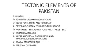
  • 1. TECTONIC ELEMENTS OF PAKISTAN It includes:  KOHISTAN-LADAKH MAGMATIC ARC  INDUS PLATE FORM AND FOREDEEP  EAST BALOCHISTAN FOLD-AND-THRUST BELT  NORTHWEST HIMALAYAN FOLD-AND- THRUST BELT  KARAKORAM BLOCK  KAKAR KHORASAN FLYSCH BASIN AND MAKRAN ACCRETIONARY ZONE  CRAGAI MAGMATIC ARC  PAKISTAN OFFSHORE
  • 2. Kohistan-Ladakh Magmatic Arc Ranges from Kohistan in Pakistan to Ladakh in india The Northern boundary of belt is known as MKT or Shyok ophiolite complex belt The Southern boundary of belt is known as IYS ophiolite complex belt The area is divided into: -Ladakh Massif -Dras Volcanic arc
  • 3. This island arc is formed within the Tethys ocean in Mesozoic times. It formed when tethy sea thrust southward and sequezed between converging indian and Asian plate. Thickness of Arc is between 50 to 70 km. Western Himalaya is an example of arc-continent collision.
  • 4.
  • 5. Indus Plateform and Foredeep • This zone extends over an area exceeding 250,000 km2 in southeastern Pakistan • It includes Indus Plain and Thar-Cholistan Deserts. • It consists of more than 80% of the population of Pakistan • It is also very valuable because of it,s coal deposits,valuable gas and oil fields and vast groundwater reservoirs. • Eastern side mainly composed of Marine and deltaic sediments of Mesozoic and Cenozoic and also have Precambrian rocks.
  • 6. There are 2 broad zones defined by gravity survey 1. Up warp 2. Down warp • Sedimentary cover is thin in the upwarp zone •Sedimentary cover is thick in the down warp zone •In foredeep it is specially very thick upto 10,000 m thick
  • 7.
  • 8. EAST BALOCHISTAN FOLD-AND-THRUST BELT • This zone of folds and thrusts is 60 to 150 km wide, with a strike length of about 1,250 km. • It extands from Waziristan through Loralai-Bugti area, around the Quetta syntaxis, down south to Karachi and the Indus Delta • The Sulaiman-Kirthar foredeeps lie on its eastern flank • Ornach-Nal Transform Fault and Ghazaband Fault are truncated on west. • Himalayan fold and thrust belt are in faulted contact with its north south structures.
  • 9. • The East Balochistan fold-and-thrust belt is the product of transpression and oblique collision of India-Pakistan plate with the Afghan block • This belt is reportedly underlain by relatively thinner transitional or oceanic crust at least in its northern part • The basement is covered by a thick Phanerozoic sedimentary wedge • Inward there is a broad folded zone with narrow anticlinal hills and wide synclinal valleys. • Magmatism is largely confined to basic dykes and sills in the Mesozoic sequence. • Metamorphism is restricted to ophiolite bearing sections of the thrust belt
  • 10. Stratigraphy and structure • The East Balochistan fold-and-thrust belt contains more than 10 km thick sequence of Permian • Mesozoic shelf carbonates, neritic shales and volcanics • Paleogene shallow-water interlayered marine and continental deposits and Neogene molasse. • There is an intimate relationship between the structure and stratigraphy of this belt • In India-Eurasia collision, the deposition centres and the deformation have gradually migrated south and eastward towards the foreland.
  • 11. • Towards the west, the outer part of the East Balochistan fold-and- thrust belt is comprised of an over 550 km long and 20 to 40 km wide imbricate zone of thrusts This belt is divided into two parts • Zhob ophiolite-and-thrust belt in the north • Bela ophiolite-and-thrust belt in the south
  • 12. NORTHWEST HIMALAYAN FOLD-AND- THRUST BELT • The Northwest Himalayan fold-and-thrust belt occupies a 250 km wide and about 560 km long. • These irregularly shaped mountainous region stretching from the Afghan border near Parachinar up to the Kashmir Basin • The Hazara-Kashmir and Nanga Parbat Syntaxes form its eastern margin. • It covers all the terrain between the Main Mantle Thrust (MMT) in the north and-the Salt Range Thrust in the south. • This region is comprised of the mountain ranges of Nanga Parbat. Hazara, southern Kohistan, Swat, Margalla, Kalachitta, KohaL Sufaid Koh, Salt Range and its western extension.
  • 13. A major thrust fault the Panjal-Khairabad Fault divides the NW Himalayan sequence into • Deformed southern zone often referred to as the external or foreland zone • Deformed and metamorphosed northern zone, also known as the hinterland zone Foreland Zone: • The foreland zone is comprised of the Hazara-Kashmir Syntaxis, Salt Range and Kohat-Potwar fold belt and the Kurram-Cherat-Margalla thrust belt Hinterland zone: • Hinterland zone comprises the Himalayan crystalline nappe-and- thrust belt
  • 14. • The eastern margin of the NW Himalayan fold-and-thrust belt in Pakistan comprises the north-south trending Hazara-Kashmir Syntaxis • In Northeast it extends upto Nanga Parbat-Haramosh Massif. Hazara-Kashmir Syntaxis: • It lies on northern corner of Pakistan, between Mirpur and Muzaffarabad and farther to the north and northeast • It consists of geological formations and broader geological structures of the Himalayas make an abrupt hairpin bend
  • 15. On western side of Hazara-Kashmir Syntaxis there are several arcuate, south verging thrust faults which terminate in the Jhelum Fault at an acute angle between Balakot and Kohala These are: 1. Main central thrust 2. Jhelum fault 3. Panjal thrust 4. Murree Fault
  • 16.
  • 17. KARAKORAM BLOCK Karakoram block is 70 to 120 km wide and 1,400 km long structural zone The Karakoram Batholith divides the region into a northern and southern sedimentary belt The western part of the region, the Tirich Mir zone, is separated from the main body of the Karakoram belt by the Tirich Fault Tirich Mir zone: • This zone is largely comprised of the highly deformed and imbricated metasediments of the Arkari Formation
  • 18. • It mainly consists of dark grey phyllites with subordinate quartzites and marbles Southern Sedimentary Belt: • The Southern belt forms an belt of highly deformed and imbricated metasediments thrust southward over the Kohistan-Ladakh sequence along the Shyok Suture zone or MKT. • In the western part of the belt, between Chitral town and Mastuj, Late Paleozoic to Tertiary rocks are exposed. • The Darkot Group is the oldest sedimentary unit with Carboniferous to Permian fossils • It also consists of slates, schists and quartzites intercalated with crystalline limestones • It has been intruded by granites and is unconformably overlain by the Tertiary
  • 19. Northern Sedimentary Belt: • The Northern sedimentary belt extends westward from Shaksgam, through Upper Hunza and Chapursan Valleys, up to Baroghil Pass. • It then bends southward and follows the Yarkhun Valley • In the Upper Hunza region, it consists of three tectonostratigraphic units separated by lwo major faults • An E-W trending reverse fault the Upper Hunza Fault • an antiformal stack and northward, across the Northern Fault, it is structurally overlain by the Misghar Unit
  • 20. KAKAR KHORASAN FLYSCH BASIN AND MAKRAN ACCRETIONARY ZONE • These two tectonic zones presently form separate and distinct structural units northwest and west of the Sulaiman-Kirthar fold-and- thrust belt • both share a common depositional history and are comprised of Cenozoic Khojak Flysch. • They are separated by the Chaman Transform Fault Zone. • The Kakar Khorasan Basin lies to the north of Zhob ophioliteand- thrust belt • As part of the large Katawaz Basin, it extends southward from near Kabul to Zhob and links up with the Makran Basin
  • 21. • The Kakar Khorasan Basin is bound to the south and east by the Zhob and Shinghar-Chukhan Manda Faults respectively. • On west it is terminated by the Chaman Fault • It is filled by 4 to 6 km thick sequence offlysch, deltaic and molasse type sediments • Gravity modelling shows that the transitional crust of the Sulaiman zone becomes thinner and deeper beneath Kakar Khorasan Basin and is overlapped by oceanic crust • Eocene Nisai Limestone and Oligocene to Miocene Khojak Flysch are exposed in the Kakar Khorasan Basin. • This sequence has been thrust southward over the Zhob Ophiolites. • The flysch is capped by Pliocene or younger molasse
  • 22. • This sequence forms broad synclines and tight anticlines cut by reverse faults. • The folds form a part of the Sulaiman oroclinal flexure. • The structural trend changes from SW in the basin to NS near the Chaman Fault. • The Chaman Fault is a major left-lateral strike-slip active fault that has been the site of moderate to large earthquakes • This fault extends • northward from Kharan to Kabul for 850 km and is considered as the western transform boundary of the Indian plate • It connects the Makran convergence zone with the Himalayan convergence zone (where Indo-Pakistan plate is underthrusting Eurasia).
  • 23. CRAGAI MAGMATIC ARC • the Chagai arc is an east-west-trending, arcuate, south-yerging magmatic belt comprised of Cretaceous to Tertiary sediments and volcanics. • It is intruded by Tertiary granites, diorites and mafic dykes and sills. Small tectonised blocks of ultramafic rocks occur in the southern part • Quaternary volcanoes dot the landscape in the northwestern section of the arc • This magmatic arc forms a part of the Makran trench arc system on the southern margin of the Afghan and Lut blocks
  • 24. It comprises three main tectonic components: 1. the North Chagai calc-alkaline and magmatic belt 2. Mirjawa-Dalbandin trough 3. the Ras Koh uplift block • Eastward the Chagai arc is abruptly truncated by the Chaman Fault • the Kakarkhorasan, Makran and Chagai regions are all parts of Makran-Chagai trench-arc system which developed in response to northward movement of the Indian and Arabian plates and subduction of the Neotethys under the southern margin of the Afghan block • Cretaceous submarine volcanism associated with periodic uplift eventually led to the formation of Chagai andesitic volcanic arc.
  • 25. PAKISTAN OFFSHORE • The Pakistan Offshore extends for 700 km from Rann of Cutch to the Iranian border (near Gwadar). • It comprises two distinct structural and sedimentary basins, the Indus and Makran Offshore Basins, which are separated by the Murray Ridge. • This ridge is an extension of the Owen Fracture Zone and forms the boundary between Indian and Arabian plates Makran Offshore: • This zone is characterised by relatively narrow shelf and slope which form the northern margin of the Gulf of Oman Abyssal Plain.
  • 26. • In this region the Arabian plate is being Gubducted beneath Makran and the subduction zone is located near the base of the continental slope • Seismic profiles indicate that the sediment pile on the Makran continental margin is about 5 km thick • In the abyssal plain these sediments are horizontally disposed but shoreward they are abruptly deformed into an approximately 50 km wide fold and thrust belt • Only the upper 2.5 km of the sedimentary sequence is folded and forms a decollement zone. • As revealed by offshore drilling, most of this sequence consists of Early Miocene and younger sediments
  • 27. Indus Offshore: • This region lies between the Murray Ridge and the Indian Coast. • It is characterised by a wide shelf and slope comprised of the vast Indus Fan It is comprised of two main structural zones: 1. Indus platform zone to the east 2. Indus depression to the west • The Indus Offshore basin contains a thick sedimentary sequence ranging from Cretaceous to Recent • Seismic profiles of this region indicate gently dipping structures with abundant down-to-the basin type normal faults
  • 28. REFERENCES: • The geological characteristics of India Ladakh - Pakistan Kohistan island arc and volcanic • rock Li Shanglinli, Ji Wenhua, Ma Boyong, Luo Yanjun , Cao xin Xi’an Center of Geological Survey· CGS. Xian 710054, Shaanxi, China China Geological Library, Beijing 100083, China and Li Guochun Inner Mongolia Institute of Geology and Mineral Resources Exploration, Huhhot 010010, Inner Mongolia, China • GEOLOGY AND TECTONICS OF PAKISTAN By A.H.KAZMI· andM.QASIMJAN • TECTONIC MODEL OF NW HIMALAYAN FOLD AND THRUST BELT ON THE BASIS OF FOCAL MECHANISM STUDIES