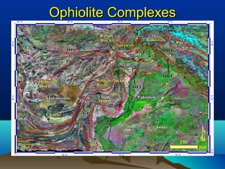
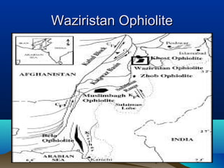
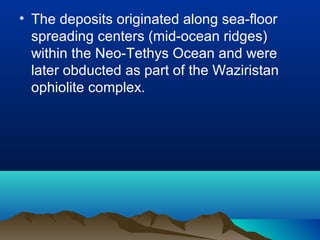
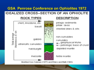
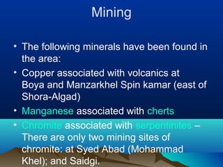
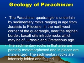
In the Name of Allah, Merciful, Beneficent
Assignment:Assignment:
Geology of Waziristan & Parachinar and theirGeology of Waziristan & Parachinar and their
tectonic evidence and Mineralization.tectonic evidence and Mineralization.
Submitted By:Submitted By:
Salah ud din Wazir, Kaleem Ullah Marwat & Ch.Salah ud din Wazir, Kaleem Ullah Marwat & Ch.
Hassnain HaheefHassnain Haheef
Submitted to:Submitted to:
Sir Abdul HannanSir Abdul Hannan
Dptt. Of Earth Sciences, University ofDptt. Of Earth Sciences, University of
Sargodha, SargodhaSargodha, Sargodha
GeoloGy of WaziristanGeoloGy of Waziristan
Regional Geology:
•Waziristan forms the westernmost part of
Himalayan fold belt in north Waziristan,
northwest Pakistan.
•It comprises a part of the Waziristan
Ophiolite Complex, shelf-slope sedimentary
rocks at the eastern tectonic contact of the
ophiolite complex, and tertiary sequence
unconformably overlaying the ophiolite.
• The Area fringes the northwestern margin
of the Indian plate and is presently
sandwiched between the Indian plate to
the east and Afghan block to the west.
• The area from west to east comprises
Afghan Kabul block, the Katawaz Basin,
the ophiolite belt.
• The region is a mosaic of continental terranes broadly
divisible into two parts. The terranes to the north of the
Herat-Wanch-Akbayal-Kun Lun fault are parts of the
Asam plate, whereas those occurring to the south of it
are the dislodged fragment of Gondwana.
• The imprints of the upper Paleozoic
orogeny are pervasive in the blocks to the
north of Herat-Kun Lun fault, and are
absent in in the blocks to it.
• The imprints of the upper Paleozoic
orogeny are pervasive in the blocks to the
north of Herat-Kun Lun fault, and are
absent in in the blocks to it.
The Waziristan ophiolite
• The Waziristan complex, covering over
500 km 2
, was tectonically emplaced
during the Paleocene to early Eocene. It
consists of ultramafic rocks, gabbros,
sheeted dikes, pillow lavas, and pelagic
sediments--a typical ophiolite suite.
• The podiform chromitites consist of
aluminochromite (Cr 2 O 3 :49-61%) with
subordinate chromian chlorite and/or
chromian serpentine + magnetite.
• In Cr-Al-Fe (super +3) + Ti space the
chromites plot in the area of alpine
chromites, but on other diagrams they
overlap the fields of chromites from alpine
and stratiform complexes.
• Many chromites are zoned with "ferrit-
chromit" margins richer in Cr/(Cr + Al) and
poorer in Mg/(Mg + Fe (super +2) ) than
the unaltered cores.
• The chlorites are generally rich in
SiO 2 and MgO and poor in Al 2 O 3 . It
appears that during greenschist facies
metamorphism (or alteration) diffusion of
Mg, Al, and some Cr from the chromite
margins toward the silicate matrix resulted
in the development of ferrit-chromit and
chlorite.
Ophiolite ComplexesOphiolite Complexes
Waziristan OphioliteWaziristan Ophiolite
Stratigraphy:
• Apart from petrography, little data are
available on the metamorphic petrology of
these complexes. Lithologies which
characterise a typical ophiolite are
present, but tectonic processes have
commonly disrupted the stratigraphic
sequence; they may better be termed as
mega-melanges.
• The ophiolites display greenschist and
lowgrade amphibolite facies assemblages
developed locally or extensively: chlorite,
actinolite, epidot~-sodic plagioclase ±
carbonate ± quartz after mafic volcanic
and plutonic rocks, and serpentine ±
carbonate ± talc ± chlorite after ultramafic
rocks.
• It is not clear whether these parageneses
are related to sea-floor emplacement or
post-emplacement metamorphic regimes.
• Information is also lacking on the nature of
metamorphism in the residual peridotites
In Bela Ophiolite, the volcanic rocks and
gabbros are spilitised and there are beds
of serpentinites ± ophicalcite debris
overlain by un metamorphosed
sedimentary rocks.
• These may, therefore, have undergone
sea-floor, metamorphism. Extensive and
intensive alteration in volcanic (hosting
promising copper mineralisation) and
some plutonic rocks in the Waziristan
Ophiolite may also have a similar origin.
• They regard that the sheeted dyke
complex in Saplai Tor Ghar consists of
dolerite, gabbro-diorite and pi agio granite
emplaced in three stages.
• This Complex displays high-grade
amphibolite to greenschist facies
metamorphism and strong to weak
foliation. The plagiogranite is considered
as a product of wet melting of the
dolerites, but no petro genetic details has
been published.
Geochemistry and origin of Mn-Geochemistry and origin of Mn-
deposits in the Waziristan ophiolitedeposits in the Waziristan ophiolite
complexcomplex::
• The Waziristan ophiolite complex is
located along the western margin of the
Indian plate in northwestern Pakistan.
• The Mn-deposits in the Saidgi and
Shuidar areas are part of this ophiolite
complex.
• These deposits, both banded and massive
in nature, are hosted by metachert and
are generally overlying metavolcanics.
• Braunite and cryptocrystalline quartz are
the main constituents of the manganese
ores in both areas. Hematite occurs in the
Shuidar deposits as a minor phase.
Metacherts are microcrystalline
aggregates of microcrystalline quartz,
chalcedony, and lesser hematite.
• Chemically, the studied Mn-deposits and
associated metacherts are very similar to
those formed by submarine hydrothermal
effusive processes.
• The deposits originated along sea-floor
spreading centers (mid-ocean ridges)
within the Neo-Tethys Ocean and were
later obducted as part of the Waziristan
ophiolite complex.
GSA Penrose Conference on Ophiolites 1972GSA Penrose Conference on Ophiolites 1972
Mining
• The following minerals have been found in
the area:
• Copper associated with volcanics at
Boya and Manzarkhel Spin kamar (east of
Shora-Algad)
• Manganese associated with cherts
• Chromite associated with serpentinites –
There are only two mining sites of
chromite: at Syed Abad (Mohammad
Khel); and Saidgi.
Geology of Parachinar:
• The Parachinar quadrangle is underlain
by sedimentary rocks ranging in age from
Jurassic to Pliocene. In the northwest
corner of the quadrangle, near the Afghan
border, basalt sills intrude rocks which
may be of Jurassic and Cretaceous age.
• The sedimentary rocks in that area are
partially metamorphosed and in places are
mineralized. The sedimentary rocks are
intensely folded and faulted.
• The northern part of the region is
underlain by Jurassic, Cretaceous, and
Paleocene limestone, sandstone, and
shale which have a total thickness of more
than 5,000 ft.
• This sequence of rocks forms the highest
mountains (Tirah Range) of the region;
these mountains, in general, trend west
and northwest across the northern third of
the map area.
• South of the Tirah Range, Eocene,
Miocene, and Pliocene rocks occupy most
of the lower tracts in the southern and
eastern parts of the area.
• The Eocene rocks consist of limestone,
clay, shale, sandstone, gypsum, and rock
salt. The thickness of exposed Eocene
rocks averages about 1,750 ft.
• The Miocene and Pliocene sequence
consists of sandstone, shale, siltstone,
conglomerate, and cobble beds totaling
more than 13,600 ft in thickness.
STRATIGRAPHY:
• The regional stratigraphy of the
Parachinar quadrangle is described from
11 widely spaced sequences measured by
members of the project, and from five
other sequences measured.
• The formations include sedimentary rocks
of Jurassic to Pliocene age.
• The following table show the stratigraphy
of Parachinar.
MINERAL RESOURCES:
• GYPSUM:
• Gypsum deposits of Eocene age (Jatta
Gypsum) found in the Kohat quadrangle
extend west for a short distance into the
Parachinar quadrangle.
• The gypsum is banded green, light brown
and white, and has intercalated green clay
beds.
ROCK SALT:
• The Eocene rock salt deposits (Bahadur
Khel Salt) found in the Kohat quadrangle
continue west for a short distance into the
Parachinar quadrangle.
• Maximum exposed thickness of the salt is
320 ft at the Bahadur Khel quarry (lat
33°09', long 70°58'E.) but it wedges out a
short distance to the north and west.
COPPER:
• A deposit of chalcopyrite, at an altitude of
10,500 ft, north of Churoke Valley, is 1%
miles N. 16° W. of the village of
Gujarghuna.
• A 120-ft-high cliff of Cretaceous quartzite
is impregnated and partially replaced by
chalcopyrite in an area at least 150 ft long.
Lateral extension of the mineralized rocks
was not explored because of the nearly
impassable cliff.
MANGANESE:
• A deposit of manganese ore in
Khapianga hill (lat 33°20'N., long
70°32/E.), about 2 miles west of the village
of Thai and 1 1/2 miles west of the Kurram
River (pi. 1), was investigated by Klinger
of the U.S. Geological Survey.
• . The ore is very hard and highly siliceous (50-60
percent chert and has an average manganese content of
probably less than 25 percent, although small pockets of
nearly pure manganese oxide are present.
THE ENDTHE END

Geology of Pakistan presentation; Salah ud din Shabab

  • 1.
    In the Nameof Allah, Merciful, Beneficent
  • 2.
    Assignment:Assignment: Geology of Waziristan& Parachinar and theirGeology of Waziristan & Parachinar and their tectonic evidence and Mineralization.tectonic evidence and Mineralization.
  • 3.
    Submitted By:Submitted By: Salahud din Wazir, Kaleem Ullah Marwat & Ch.Salah ud din Wazir, Kaleem Ullah Marwat & Ch. Hassnain HaheefHassnain Haheef Submitted to:Submitted to: Sir Abdul HannanSir Abdul Hannan Dptt. Of Earth Sciences, University ofDptt. Of Earth Sciences, University of Sargodha, SargodhaSargodha, Sargodha
  • 4.
    GeoloGy of WaziristanGeoloGyof Waziristan Regional Geology: •Waziristan forms the westernmost part of Himalayan fold belt in north Waziristan, northwest Pakistan. •It comprises a part of the Waziristan Ophiolite Complex, shelf-slope sedimentary rocks at the eastern tectonic contact of the ophiolite complex, and tertiary sequence unconformably overlaying the ophiolite.
  • 5.
    • The Areafringes the northwestern margin of the Indian plate and is presently sandwiched between the Indian plate to the east and Afghan block to the west. • The area from west to east comprises Afghan Kabul block, the Katawaz Basin, the ophiolite belt. • The region is a mosaic of continental terranes broadly divisible into two parts. The terranes to the north of the Herat-Wanch-Akbayal-Kun Lun fault are parts of the Asam plate, whereas those occurring to the south of it are the dislodged fragment of Gondwana.
  • 6.
    • The imprintsof the upper Paleozoic orogeny are pervasive in the blocks to the north of Herat-Kun Lun fault, and are absent in in the blocks to it. • The imprints of the upper Paleozoic orogeny are pervasive in the blocks to the north of Herat-Kun Lun fault, and are absent in in the blocks to it.
  • 7.
    The Waziristan ophiolite •The Waziristan complex, covering over 500 km 2 , was tectonically emplaced during the Paleocene to early Eocene. It consists of ultramafic rocks, gabbros, sheeted dikes, pillow lavas, and pelagic sediments--a typical ophiolite suite. • The podiform chromitites consist of aluminochromite (Cr 2 O 3 :49-61%) with subordinate chromian chlorite and/or chromian serpentine + magnetite.
  • 8.
    • In Cr-Al-Fe(super +3) + Ti space the chromites plot in the area of alpine chromites, but on other diagrams they overlap the fields of chromites from alpine and stratiform complexes. • Many chromites are zoned with "ferrit- chromit" margins richer in Cr/(Cr + Al) and poorer in Mg/(Mg + Fe (super +2) ) than the unaltered cores.
  • 9.
    • The chloritesare generally rich in SiO 2 and MgO and poor in Al 2 O 3 . It appears that during greenschist facies metamorphism (or alteration) diffusion of Mg, Al, and some Cr from the chromite margins toward the silicate matrix resulted in the development of ferrit-chromit and chlorite.
  • 10.
  • 11.
  • 12.
    Stratigraphy: • Apart frompetrography, little data are available on the metamorphic petrology of these complexes. Lithologies which characterise a typical ophiolite are present, but tectonic processes have commonly disrupted the stratigraphic sequence; they may better be termed as mega-melanges.
  • 13.
    • The ophiolitesdisplay greenschist and lowgrade amphibolite facies assemblages developed locally or extensively: chlorite, actinolite, epidot~-sodic plagioclase ± carbonate ± quartz after mafic volcanic and plutonic rocks, and serpentine ± carbonate ± talc ± chlorite after ultramafic rocks. • It is not clear whether these parageneses are related to sea-floor emplacement or post-emplacement metamorphic regimes.
  • 14.
    • Information isalso lacking on the nature of metamorphism in the residual peridotites In Bela Ophiolite, the volcanic rocks and gabbros are spilitised and there are beds of serpentinites ± ophicalcite debris overlain by un metamorphosed sedimentary rocks. • These may, therefore, have undergone sea-floor, metamorphism. Extensive and intensive alteration in volcanic (hosting promising copper mineralisation) and some plutonic rocks in the Waziristan Ophiolite may also have a similar origin.
  • 15.
    • They regardthat the sheeted dyke complex in Saplai Tor Ghar consists of dolerite, gabbro-diorite and pi agio granite emplaced in three stages. • This Complex displays high-grade amphibolite to greenschist facies metamorphism and strong to weak foliation. The plagiogranite is considered as a product of wet melting of the dolerites, but no petro genetic details has been published.
  • 16.
    Geochemistry and originof Mn-Geochemistry and origin of Mn- deposits in the Waziristan ophiolitedeposits in the Waziristan ophiolite complexcomplex:: • The Waziristan ophiolite complex is located along the western margin of the Indian plate in northwestern Pakistan. • The Mn-deposits in the Saidgi and Shuidar areas are part of this ophiolite complex. • These deposits, both banded and massive in nature, are hosted by metachert and are generally overlying metavolcanics.
  • 17.
    • Braunite andcryptocrystalline quartz are the main constituents of the manganese ores in both areas. Hematite occurs in the Shuidar deposits as a minor phase. Metacherts are microcrystalline aggregates of microcrystalline quartz, chalcedony, and lesser hematite. • Chemically, the studied Mn-deposits and associated metacherts are very similar to those formed by submarine hydrothermal effusive processes.
  • 18.
    • The depositsoriginated along sea-floor spreading centers (mid-ocean ridges) within the Neo-Tethys Ocean and were later obducted as part of the Waziristan ophiolite complex.
  • 19.
    GSA Penrose Conferenceon Ophiolites 1972GSA Penrose Conference on Ophiolites 1972
  • 20.
    Mining • The followingminerals have been found in the area: • Copper associated with volcanics at Boya and Manzarkhel Spin kamar (east of Shora-Algad) • Manganese associated with cherts • Chromite associated with serpentinites – There are only two mining sites of chromite: at Syed Abad (Mohammad Khel); and Saidgi.
  • 21.
    Geology of Parachinar: •The Parachinar quadrangle is underlain by sedimentary rocks ranging in age from Jurassic to Pliocene. In the northwest corner of the quadrangle, near the Afghan border, basalt sills intrude rocks which may be of Jurassic and Cretaceous age. • The sedimentary rocks in that area are partially metamorphosed and in places are mineralized. The sedimentary rocks are intensely folded and faulted.
  • 22.
    • The northernpart of the region is underlain by Jurassic, Cretaceous, and Paleocene limestone, sandstone, and shale which have a total thickness of more than 5,000 ft. • This sequence of rocks forms the highest mountains (Tirah Range) of the region; these mountains, in general, trend west and northwest across the northern third of the map area.
  • 23.
    • South ofthe Tirah Range, Eocene, Miocene, and Pliocene rocks occupy most of the lower tracts in the southern and eastern parts of the area. • The Eocene rocks consist of limestone, clay, shale, sandstone, gypsum, and rock salt. The thickness of exposed Eocene rocks averages about 1,750 ft. • The Miocene and Pliocene sequence consists of sandstone, shale, siltstone, conglomerate, and cobble beds totaling more than 13,600 ft in thickness.
  • 24.
    STRATIGRAPHY: • The regionalstratigraphy of the Parachinar quadrangle is described from 11 widely spaced sequences measured by members of the project, and from five other sequences measured. • The formations include sedimentary rocks of Jurassic to Pliocene age. • The following table show the stratigraphy of Parachinar.
  • 26.
    MINERAL RESOURCES: • GYPSUM: •Gypsum deposits of Eocene age (Jatta Gypsum) found in the Kohat quadrangle extend west for a short distance into the Parachinar quadrangle. • The gypsum is banded green, light brown and white, and has intercalated green clay beds.
  • 27.
    ROCK SALT: • TheEocene rock salt deposits (Bahadur Khel Salt) found in the Kohat quadrangle continue west for a short distance into the Parachinar quadrangle. • Maximum exposed thickness of the salt is 320 ft at the Bahadur Khel quarry (lat 33°09', long 70°58'E.) but it wedges out a short distance to the north and west.
  • 28.
    COPPER: • A depositof chalcopyrite, at an altitude of 10,500 ft, north of Churoke Valley, is 1% miles N. 16° W. of the village of Gujarghuna. • A 120-ft-high cliff of Cretaceous quartzite is impregnated and partially replaced by chalcopyrite in an area at least 150 ft long. Lateral extension of the mineralized rocks was not explored because of the nearly impassable cliff.
  • 29.
    MANGANESE: • A depositof manganese ore in Khapianga hill (lat 33°20'N., long 70°32/E.), about 2 miles west of the village of Thai and 1 1/2 miles west of the Kurram River (pi. 1), was investigated by Klinger of the U.S. Geological Survey. • . The ore is very hard and highly siliceous (50-60 percent chert and has an average manganese content of probably less than 25 percent, although small pockets of nearly pure manganese oxide are present.
  • 30.