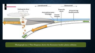
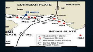
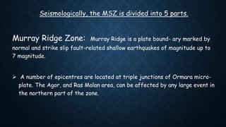
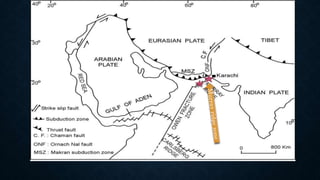
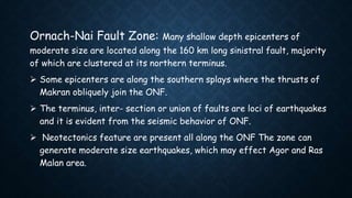
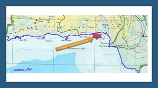
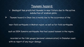
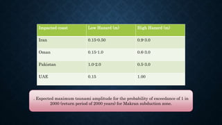
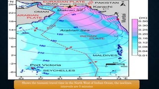
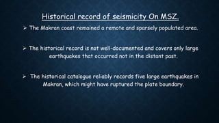
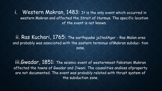
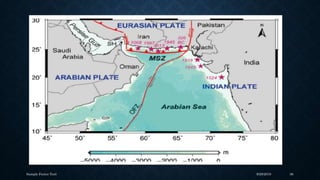
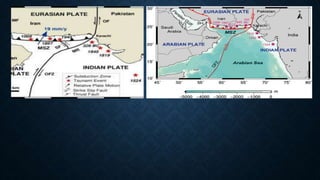
the UNIVERSITYOF AZADJAMMUANDKASHMIR
MUZAFFARABAD
The Institute of Geology
Topic: The Makran Subduction Zone
Prepared by : Mashwani
Group No: Fourth
Roll numbers: From 125 to 134
presented To:
Sir Fahad Hameed SB
And whole class
Abdur Rauf Mashwani
Roll no: 125
The Makran Subduction Zone
 South-western Pakistan has an important geo- tectonic setting where
Eurasian, Arabian and Indian plates are interacting.
 In the west the oceanic floor of the Gulf of Oman is actively subducting
northwards beneath the Afghan and Lut blocks of Eurasia forming a
continental margin.
 The subduction and resulting geological features constitute a tectonic
province, called as Makran Subduction Zone.
N
Eurasian plate
Photograph no.1: This Diagram shows the Eurasian-Arabic plates collision
 The eastern limit of Makran is the sinistral Ornach- Nal Fault (ONF), which
is a southern extension of the Chaman fault: a boundary between Indian and
Eurasian plate.
 Southwards in the offshore region, the ONF extend as northeast trending
Murray ridge, which is a volcanic ridge of sea mounts.
 The Minab Fault system in Iran joins the western edge of Makran with
Zagros fold and thrust belt.
 The east-west extent of the Makran arc-trench system is less than
1000 km in extent.
 and in the north-south direction it widens from
about 400 km in the west to about 600 km in the east.
 Global Positioning System (GPS) studies indicate that the rate of
subduction is about 19.5 mm/y.
 When compare to the subduction zones in the world, MSZ is slow motion
subduction zone with enormously low angle and ranges from 2◦ to 8◦.
The Makran subduction zone
Baluchistan
Basin
Tahir Rizwan
Roll no: 126
;
The stratigraphy Of Makran areas of Pakistan
 The Makran accretionary wedge stretches from Iran to central
Pakistan and off the south coast of this area.
 It has been formed by the subduction of the oceanic portion of the
Arabian Plate beneath Eurasia.
 and is built up by sediments scraped off the Arabian Plate since early
Tertiary.
 Subduction was probably initiated during Paleocene and accretion started
during Eocene times .
 The modern Makran accretionary prism has developed since Late
Miocene , and is still propagating seaward at a rate of ~10 mm yr.
Two features make this accretionary wedge unusual:
 (1) the sediment thickness on top of the oceanic crust is extremely high
(at least 6 km).
 and (2) the dip angle of subduction is extremely low 2 to 8 degree.
 Makran is an EW trending prism developed as along steeply dipping
thrusts.
 A northwest trending a consequence of ongoing subduction since Creta- sinistral
fault.
 The arc - trench gap is unusually large and the deformed Andean - type andesitic
Chagai arc re- mained active up to Quaternary .
 The accretionary wedge of sediments developed between buried offshore trench
and its large part is lying over mobile oceanic Arabian plate dipping at shallow
angle.
 The subducting lithosphere is broken along large basement faults perpendicular
to trench, dividing the plate into variously dipping digitate segments .
Age FORMATION Lithology Characteristics Environment of
Deposition
Holocene Jiwani Formation limestone, conglomerate (Lime stone) and
sandstone.
30METERS
The limestone is
coquina of small shell
shoreline facies.
Latest
Pleistocene
Ormara Formation Shale, sandstone, and conglomerate. soft, poorly
consolidated S.stone
regressive cycle from
inner shelf to
nearshore marine.
Early Pleistocene Chati Formation mudstone/siltstone and thin impure limestone
beds.
Shelf Marine
Pliocene Talar Formation Marine sandstone, shale and mudstone sandstone is medium
to coarse grained, soft
and crumbly.
5000M Thickness
Marine,
inner shelf and
nearshore
Late
Miocene
Parkini Formation calcareous mudstone,
very fine grained sandstone
thickly-bedded Shallow Marine
Middle
Miocene
Pnjgur Formation Shale and sandstone.
Sandstones are micaceous, quartzos, fine
medium grained.
turbidity currents
4oo meter Thickness
Marine
Early
Miocene
Hoshab Formation Shales with subordinate sandstone.
-----
Deep water
The stratigraphy of Makran Coastal Areas Of Pakistan.
Kamran Ahmad Khan
Roll no: 127
Seismicity along makran subduction zone.
 At makran subduction zone, the Arabian plate is being subducted by the
Eurasian plate.
 Its eastern part is quite active as compared to western part.
 The historical study illustrates that the eastern part of Makran has
many seismicity records but the western part exhibited no.
Seismologically, the MSZ is divided into 5 parts.
Murray Ridge Zone: Murray Ridge is a plate bound- ary marked by
normal and strike slip fault-related shallow earthquakes of magnitude up to
7 magnitude.
 A number of epicentres are located at triple junctions of Ormara micro-
plate. The Agor, and Ras Malan area, can be affected by any large event in
the northern part of the zone.
Central Makran Zone: The zone is marked by sparse seismicity,
however, neotectonics feature are documented along faults.
 The focal depths are generally about 30 km, indicating that the
seismicity is associated with the basal decollement. It can generate
moderate size earthquakes.
Northern Makran-Chagai Arc Zone: The northern Makran
exhibits moderate seismicity of intermediate depth, with the exception of
a large event of 1914.
Muhammad Hamza Akbar
Roll no: 129
 Western Zone: The NNW trending zone lies in Iran. Many
seismic events are located in the zone.
 Fault plane solution of an event revealed dextral strike slip motion.
 The epicenters are aligned in the direction of Sistan suture lying to the
north.
 It may be representing some basement fault.
 The zone is located about 100 km to the west of Gwadar and large
event in the zone may cause damage in Jiwani and Gwadar areas.
Ornach-Nai Fault Zone: Many shallow depth epicenters of
moderate size are located along the 160 km long sinistral fault, majority
of which are clustered at its northern terminus.
 Some epicenters are along the southern splays where the thrusts of
Makran obliquely join the ONF.
 The terminus, inter- section or union of faults are loci of earthquakes
and it is evident from the seismic behavior of ONF.
 Neotectonics feature are present all along the ONF The zone can
generate moderate size earthquakes, which may effect Agor and Ras
Malan area.
Sayed Ajwad Anayat
Roll no: 130
Tsunami hazard:
 Geologist has predicted tsunami in near future due to the active
subduction of arabian plate.
 Tsunami hazard in Oman Sea is mainly due to the occurrence of the
near-field earthquake in Makran region; as well as far-field earthquake
such as 2004 Sumatra earthquake that had caused tsunami in the region,
recorded on the tidal gauges (personal communication) in Chabehar coast,
with no report of any major damage.
 A tsunami generated in the region could reach the Iranian and
Pakistani coast under 15-20 minutes and Arabian Peninsula within an
hour.
 Such a tsunami can propagate in any direction and thus, dependent on
the location of the source, path of propagation and near-shore
morphology form a risk to any vulnerable coastline surrounding the area.
Impacted coast Low Hazard (m) High Hazard (m)
Iran 0.15-0.50 0.9-3.0
Oman 0.15-1.0 0.6-3.0
Pakistan 1.0-2.0 0.5-3.0
UAE 0.15 1.00
. Expected maximum tsunami amplitude for the probability of exceedance of 1 in
2000 (return period of 2000 years) for Makran subduction zone.
Shows the tsunami travel time in the North West of Indian Ocean, the isoclines
intervals are 5 minutes
Muhammad Altaf
Roll no: 131
Historical record of seismicity On MSZ.
 The Makran coast remained a remote and sparsely populated area.
 The historical record is not well-documented and covers only large
earthquakes that occurred not in the distant past.
 The historical catalogue reliably records five large earthquakes in
Makran, which might have ruptured the plate boundary.
i. Western Makran, 1483: It is the only event which occurred in
western Makran and affected the Strait of Hurmus. The specific location
of the event is not known.
ii. Ras Kuchari, 1765: The earthquake jo1tedAgor - Ras Malan area
and probably was associated with the eastern terminus ofMakran subduc- tion
zone.
iii.Gwadar, 1851: The seismic event of westernmost Pakistani Makran
affected the towns of Gwadar and Jiwani. The causalities andloss ofproperty
are not documented. The event was probably related with thrust system of
the subduction zone.
Iv: Gwadar, 1864:The event occurred in the same area which was
effected by the event of 185 1. It is supposed that the event was
associated with the same rupture zone responsible for the event of 1851.
V:Northern Makran, 1914: The epicentre of the earthquake is not
exactly known. It occurred in the northern Makran at a depth of 60-100
km. The rupture was in the down going slab.
Sample Footer Text 9/29/2018 36
Awrang zeb Mama
Roll no:134
 The most recent tsunamigenic event occurred in western Makran, Pakistan at
03:26 IST (Indian Standard Time) on 28 November 1945 with a
magnitude of 8.1.
 It is the only large earthquake that recorded instrumentally, which allows to
be used as validation in modeling and simulation.
 The earthquake was felt in Karachi, Pakistan, where ground motions
lasted approximately 30 seconds, stopping the clock in the Karachi
Municipality Building and interrupting the communication cable link between
Karachi and Muscat, Oman.
 c
 Ground motions were felt as far away as Calcutta, on the eastern side of
 the Indian subcontinent.
 The damage from the earthquake was great, but the greatest destruction
 to the region was caused by the tsunami that was generated.
 Tsunami waves "swept the whole of the Oman Sea coast.
 It is estimated that 4,000 people were killed.
‫مننه‬ ‫ډیره‬ ‫ډیره‬ ‫ټولو‬ ‫د‬ ‫سو‬ ‫ستا‬.
Thank you.
REFERENCES
I: Tsunami in Makran Region and Its Effect on the Persian Gulf
Mohammad Mokhtari International Institute of Earthquake Engineering
and Seismology, Iran.
II: Tsunamigenic Analysis in and around Makran, Journal of Earthquake
Engineering, 19:332–355, 2015.
III: Geology and tectonics of Pakistan by kazmi and jan.
Iv: The transition between Makran subduction and the Zagros collision:
recent advances in its structure and Active deformation
V: Omar, K. (2005). Over 4,000 people were killed when Tsunami hit
Balochistan Coast. The News International, Pakistan, 9 April 2005.
Vi: Jordan, B.R., (2008). Tsunamis of the Arabian Peninsula a guide to
historical events, Science of Tsunami Hazards, Vol. 27, No. 1, pp. 31.
Vii: Davis, D. M., and Lillie, R. J. (1994). Changing mechanical response
during continental collision: active examples from the foreland thrust
belts of Pakistan. J. Struct. Geol. 16, 21-34.

The Makran subduction zone.

  • 2.
    the UNIVERSITYOF AZADJAMMUANDKASHMIR MUZAFFARABAD TheInstitute of Geology Topic: The Makran Subduction Zone Prepared by : Mashwani Group No: Fourth Roll numbers: From 125 to 134 presented To: Sir Fahad Hameed SB And whole class
  • 3.
  • 4.
  • 5.
     South-western Pakistanhas an important geo- tectonic setting where Eurasian, Arabian and Indian plates are interacting.  In the west the oceanic floor of the Gulf of Oman is actively subducting northwards beneath the Afghan and Lut blocks of Eurasia forming a continental margin.  The subduction and resulting geological features constitute a tectonic province, called as Makran Subduction Zone.
  • 6.
    N Eurasian plate Photograph no.1:This Diagram shows the Eurasian-Arabic plates collision
  • 7.
     The easternlimit of Makran is the sinistral Ornach- Nal Fault (ONF), which is a southern extension of the Chaman fault: a boundary between Indian and Eurasian plate.  Southwards in the offshore region, the ONF extend as northeast trending Murray ridge, which is a volcanic ridge of sea mounts.  The Minab Fault system in Iran joins the western edge of Makran with Zagros fold and thrust belt.
  • 8.
     The east-westextent of the Makran arc-trench system is less than 1000 km in extent.  and in the north-south direction it widens from about 400 km in the west to about 600 km in the east.  Global Positioning System (GPS) studies indicate that the rate of subduction is about 19.5 mm/y.  When compare to the subduction zones in the world, MSZ is slow motion subduction zone with enormously low angle and ranges from 2◦ to 8◦.
  • 9.
    The Makran subductionzone Baluchistan Basin
  • 10.
  • 11.
    The stratigraphy OfMakran areas of Pakistan  The Makran accretionary wedge stretches from Iran to central Pakistan and off the south coast of this area.  It has been formed by the subduction of the oceanic portion of the Arabian Plate beneath Eurasia.  and is built up by sediments scraped off the Arabian Plate since early Tertiary.  Subduction was probably initiated during Paleocene and accretion started during Eocene times .
  • 12.
     The modernMakran accretionary prism has developed since Late Miocene , and is still propagating seaward at a rate of ~10 mm yr. Two features make this accretionary wedge unusual:  (1) the sediment thickness on top of the oceanic crust is extremely high (at least 6 km).  and (2) the dip angle of subduction is extremely low 2 to 8 degree.
  • 13.
     Makran isan EW trending prism developed as along steeply dipping thrusts.  A northwest trending a consequence of ongoing subduction since Creta- sinistral fault.  The arc - trench gap is unusually large and the deformed Andean - type andesitic Chagai arc re- mained active up to Quaternary .  The accretionary wedge of sediments developed between buried offshore trench and its large part is lying over mobile oceanic Arabian plate dipping at shallow angle.  The subducting lithosphere is broken along large basement faults perpendicular to trench, dividing the plate into variously dipping digitate segments .
  • 14.
    Age FORMATION LithologyCharacteristics Environment of Deposition Holocene Jiwani Formation limestone, conglomerate (Lime stone) and sandstone. 30METERS The limestone is coquina of small shell shoreline facies. Latest Pleistocene Ormara Formation Shale, sandstone, and conglomerate. soft, poorly consolidated S.stone regressive cycle from inner shelf to nearshore marine. Early Pleistocene Chati Formation mudstone/siltstone and thin impure limestone beds. Shelf Marine Pliocene Talar Formation Marine sandstone, shale and mudstone sandstone is medium to coarse grained, soft and crumbly. 5000M Thickness Marine, inner shelf and nearshore Late Miocene Parkini Formation calcareous mudstone, very fine grained sandstone thickly-bedded Shallow Marine Middle Miocene Pnjgur Formation Shale and sandstone. Sandstones are micaceous, quartzos, fine medium grained. turbidity currents 4oo meter Thickness Marine Early Miocene Hoshab Formation Shales with subordinate sandstone. ----- Deep water The stratigraphy of Makran Coastal Areas Of Pakistan.
  • 15.
  • 16.
    Seismicity along makransubduction zone.  At makran subduction zone, the Arabian plate is being subducted by the Eurasian plate.  Its eastern part is quite active as compared to western part.  The historical study illustrates that the eastern part of Makran has many seismicity records but the western part exhibited no.
  • 18.
    Seismologically, the MSZis divided into 5 parts. Murray Ridge Zone: Murray Ridge is a plate bound- ary marked by normal and strike slip fault-related shallow earthquakes of magnitude up to 7 magnitude.  A number of epicentres are located at triple junctions of Ormara micro- plate. The Agor, and Ras Malan area, can be affected by any large event in the northern part of the zone.
  • 20.
    Central Makran Zone:The zone is marked by sparse seismicity, however, neotectonics feature are documented along faults.  The focal depths are generally about 30 km, indicating that the seismicity is associated with the basal decollement. It can generate moderate size earthquakes. Northern Makran-Chagai Arc Zone: The northern Makran exhibits moderate seismicity of intermediate depth, with the exception of a large event of 1914.
  • 22.
  • 23.
     Western Zone:The NNW trending zone lies in Iran. Many seismic events are located in the zone.  Fault plane solution of an event revealed dextral strike slip motion.  The epicenters are aligned in the direction of Sistan suture lying to the north.  It may be representing some basement fault.  The zone is located about 100 km to the west of Gwadar and large event in the zone may cause damage in Jiwani and Gwadar areas.
  • 25.
    Ornach-Nai Fault Zone:Many shallow depth epicenters of moderate size are located along the 160 km long sinistral fault, majority of which are clustered at its northern terminus.  Some epicenters are along the southern splays where the thrusts of Makran obliquely join the ONF.  The terminus, inter- section or union of faults are loci of earthquakes and it is evident from the seismic behavior of ONF.  Neotectonics feature are present all along the ONF The zone can generate moderate size earthquakes, which may effect Agor and Ras Malan area.
  • 27.
  • 28.
    Tsunami hazard:  Geologisthas predicted tsunami in near future due to the active subduction of arabian plate.  Tsunami hazard in Oman Sea is mainly due to the occurrence of the near-field earthquake in Makran region; as well as far-field earthquake such as 2004 Sumatra earthquake that had caused tsunami in the region, recorded on the tidal gauges (personal communication) in Chabehar coast, with no report of any major damage.
  • 29.
     A tsunamigenerated in the region could reach the Iranian and Pakistani coast under 15-20 minutes and Arabian Peninsula within an hour.  Such a tsunami can propagate in any direction and thus, dependent on the location of the source, path of propagation and near-shore morphology form a risk to any vulnerable coastline surrounding the area.
  • 30.
    Impacted coast LowHazard (m) High Hazard (m) Iran 0.15-0.50 0.9-3.0 Oman 0.15-1.0 0.6-3.0 Pakistan 1.0-2.0 0.5-3.0 UAE 0.15 1.00 . Expected maximum tsunami amplitude for the probability of exceedance of 1 in 2000 (return period of 2000 years) for Makran subduction zone.
  • 31.
    Shows the tsunamitravel time in the North West of Indian Ocean, the isoclines intervals are 5 minutes
  • 32.
  • 33.
    Historical record ofseismicity On MSZ.  The Makran coast remained a remote and sparsely populated area.  The historical record is not well-documented and covers only large earthquakes that occurred not in the distant past.  The historical catalogue reliably records five large earthquakes in Makran, which might have ruptured the plate boundary.
  • 34.
    i. Western Makran,1483: It is the only event which occurred in western Makran and affected the Strait of Hurmus. The specific location of the event is not known. ii. Ras Kuchari, 1765: The earthquake jo1tedAgor - Ras Malan area and probably was associated with the eastern terminus ofMakran subduc- tion zone. iii.Gwadar, 1851: The seismic event of westernmost Pakistani Makran affected the towns of Gwadar and Jiwani. The causalities andloss ofproperty are not documented. The event was probably related with thrust system of the subduction zone.
  • 35.
    Iv: Gwadar, 1864:Theevent occurred in the same area which was effected by the event of 185 1. It is supposed that the event was associated with the same rupture zone responsible for the event of 1851. V:Northern Makran, 1914: The epicentre of the earthquake is not exactly known. It occurred in the northern Makran at a depth of 60-100 km. The rupture was in the down going slab.
  • 36.
    Sample Footer Text9/29/2018 36
  • 37.
  • 38.
     The mostrecent tsunamigenic event occurred in western Makran, Pakistan at 03:26 IST (Indian Standard Time) on 28 November 1945 with a magnitude of 8.1.  It is the only large earthquake that recorded instrumentally, which allows to be used as validation in modeling and simulation.  The earthquake was felt in Karachi, Pakistan, where ground motions lasted approximately 30 seconds, stopping the clock in the Karachi Municipality Building and interrupting the communication cable link between Karachi and Muscat, Oman.  c
  • 39.
     Ground motionswere felt as far away as Calcutta, on the eastern side of  the Indian subcontinent.  The damage from the earthquake was great, but the greatest destruction  to the region was caused by the tsunami that was generated.  Tsunami waves "swept the whole of the Oman Sea coast.  It is estimated that 4,000 people were killed.
  • 41.
    ‫مننه‬ ‫ډیره‬ ‫ډیره‬‫ټولو‬ ‫د‬ ‫سو‬ ‫ستا‬. Thank you.
  • 42.
    REFERENCES I: Tsunami inMakran Region and Its Effect on the Persian Gulf Mohammad Mokhtari International Institute of Earthquake Engineering and Seismology, Iran. II: Tsunamigenic Analysis in and around Makran, Journal of Earthquake Engineering, 19:332–355, 2015. III: Geology and tectonics of Pakistan by kazmi and jan. Iv: The transition between Makran subduction and the Zagros collision: recent advances in its structure and Active deformation
  • 43.
    V: Omar, K.(2005). Over 4,000 people were killed when Tsunami hit Balochistan Coast. The News International, Pakistan, 9 April 2005. Vi: Jordan, B.R., (2008). Tsunamis of the Arabian Peninsula a guide to historical events, Science of Tsunami Hazards, Vol. 27, No. 1, pp. 31. Vii: Davis, D. M., and Lillie, R. J. (1994). Changing mechanical response during continental collision: active examples from the foreland thrust belts of Pakistan. J. Struct. Geol. 16, 21-34.