This document describes the Baluchistan basin of Pakistan.
stratigraphy, source rocks, reservoir rocks, seal rocks, trapping mechanism of Baluchistan basin.
thanks to my class fellow for help.
The Makran coast is located along an active boundary lying in the offshore region where Arabian plate is being actively subducted northwards beneath Afghan and blocks. The active margin of Makran Coast remained a site of earthquakes throughout the historical and modern times. This scenario warrants a seismotectonic analysis of the Makran coastal areas to asses risk factors both for human settlements as well as important civil structures. The reconnaissance seismotectonic studies along the Makran coast resulted in the identification of a number of seismites ofHolocene times associated with capable faults. The instrumental and historicseismicity catalogue reveals that the Makran coast active margin is marked by low seismicity presently clustered in the south ofPasni. The infrequent large events occurred all along the Makran coast. The event of 1945 (magnitude 8. I) with shallow depth of 25 km located near Pasni caused ground ruptures, modification of landscape, rock falls, liquefactions,Fre and 5 to 10 m high tsunami.
Information about these fluids is an invaluable aid in mineral exploration.
Conventional academic methods of analysing fluid inclusions are too slow and tedious to be of practical application in typical mineral exploration activities.
However, the academic data from numerous studies does show that CO2 is an exceptionally important indicator when exploring for most types of gold deposit.
Because the baro-acoustic decrepitation method is a rapid and reliable method to measure CO2 contents in fluids, it can be used to study a spatial array of data and it is an invaluable and practical exploration method.
Measurements of temperatures of fluid inclusions does not usually help in mineral exploration as hydrothermal minerals deposit over a wide temperature range and there is no specific temperature which is indicative of mineralisation. However, if temperatures are available on a large spatial array of samples, then temperature trends may be a useful exploration method to find the hottest part of the system, which is presumably the location of the best economic mineralisation. Baro-acoustic decrepitation is the most practical method to determine temperatures of the large numbers of samples required.
Salinities of fluid inclusions are of limited use in exploration and are difficult to measure. However, they can be used to recognise intrusion related hydrothermal systems.
This is my presentation on the tectonic control of sediments.
It includes the effects of tectonics either direct or indirect on sediments and sedimentation.
Sedimentation along various plate boundaries.
Few examples as evidence from Pakistan (the Siwalik Group) and Argentina (Fiambala Basin)
Its all about the summary of what geological episodes happened in the past that results in existence of Pakistan. And then discussion about main segments and main features of Pakistan.
STUDY OF IMPORTANT METAMORPHIC ROCKS.pdfRITISHASINGH7
Study of important metamorphic rocks-
Petrological Characteristics, Indian Stratigraphic Position, Locality, Economic Importance and Facts about -
Granulite, Charnockite,
Eclogite, migmatites, Khondalite, Gondites.
To understand the General Tectonic setting of Pakistan which includes all tectonic segments and the currently active convergent boundaries present in Pakistan
Ravva - Cairn’s first development success story has been the bedrock of innovation, and the foundation of our success story in the country and the region. Ravva, which in Sanskrit and Telegu means “diamond” showcases the journey of growth that Cairn has been able to achieve in its business. Incidentally, Ravva is the only field in India to get such a unique name indicating the belief of the nation in it.
The term "trap" has been used in geology since 1785–95 for rock formations. It is derived from the Swedish word for stairs (trapp , trappa) and refers to the step-like hills forming the landscape of the region.
The plateau: also called a high plain or tableland, is an area of highland, usually consisting of relatively flat terrain. A plateau is an elevated land. It is a flat-topped table standing above the surrounding area. A plateau may have one or more sides with steep slopes.
LIP – Large Igneous provinces. (Province = Area / Region)
DVP - The Deccan Volcanic Province is one of the Earth’s giant continental flood basalts and has a total exposed area of about half a million square kilometers in Maharashtra, Madhya Pradesh, Gujrat and some part of Andhra Pradesh. Deccan trap has maximum thickness 3400m in western ghat and its thickness goes decrease toward east side. At Amrakantat on east its thickness is just 160m. Geographical distribution is between latitudes 16° - 24° N and longitudes 70° - 77° E.
Safalta Digital marketing institute in Noida, provide complete applications that encompass a huge range of virtual advertising and marketing additives, which includes search engine optimization, virtual communication advertising, pay-per-click on marketing, content material advertising, internet analytics, and greater. These university courses are designed for students who possess a comprehensive understanding of virtual marketing strategies and attributes.Safalta Digital Marketing Institute in Noida is a first choice for young individuals or students who are looking to start their careers in the field of digital advertising. The institute gives specialized courses designed and certification.
for beginners, providing thorough training in areas such as SEO, digital communication marketing, and PPC training in Noida. After finishing the program, students receive the certifications recognised by top different universitie, setting a strong foundation for a successful career in digital marketing.
Macroeconomics- Movie Location
This will be used as part of your Personal Professional Portfolio once graded.
Objective:
Prepare a presentation or a paper using research, basic comparative analysis, data organization and application of economic information. You will make an informed assessment of an economic climate outside of the United States to accomplish an entertainment industry objective.
Introduction to AI for Nonprofits with Tapp NetworkTechSoup
Dive into the world of AI! Experts Jon Hill and Tareq Monaur will guide you through AI's role in enhancing nonprofit websites and basic marketing strategies, making it easy to understand and apply.
Model Attribute Check Company Auto PropertyCeline George
In Odoo, the multi-company feature allows you to manage multiple companies within a single Odoo database instance. Each company can have its own configurations while still sharing common resources such as products, customers, and suppliers.
How to Make a Field invisible in Odoo 17Celine George
It is possible to hide or invisible some fields in odoo. Commonly using “invisible” attribute in the field definition to invisible the fields. This slide will show how to make a field invisible in odoo 17.
The French Revolution, which began in 1789, was a period of radical social and political upheaval in France. It marked the decline of absolute monarchies, the rise of secular and democratic republics, and the eventual rise of Napoleon Bonaparte. This revolutionary period is crucial in understanding the transition from feudalism to modernity in Europe.
For more information, visit-www.vavaclasses.com
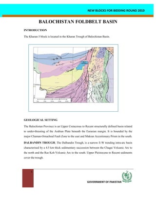
1. 1
GOVERNMENT OF PAKISTAN
NEW BLOCKS FOR BIDDING ROUND 2010
BALOCHISTAN FOLDBELT BASIN
INTRODUCTION
The Kharan-3 block is located in the Kharan Trough of Balochistan Basin.
GEOLOGICAL SETTING
The Balochistan Province is an Upper Cretaceous to Recent structurally defined basin related
to under-thrusting of the Arabian Plate beneath the Eurasian margin. It is bounded by the
major Chaman-Ornachnal Fault Zone to the east and Makran Accretionary Prism in the south.
DALBANDIN TROUGH; The Dalbandin Trough, is a narrow E-W trending intra-arc basin
characterised by a 4.5 km thick sedimentary succession between the Chagai Volcanic Arc to
the north and the Ras Koh Volcanic Arc to the south. Upper Pleistocene to Recent sediments
cover the trough.
2. 2
GOVERNMENT OF PAKISTAN
NEW BLOCKS FOR BIDDING ROUND 2010
KHARAN TROUGH; Kharan Trough is 150km wide and 300km long fore-arc basin
bounded by the Ras Koh arc to the north and the Makran accretionary prism to the south. It
extends to the Hamun-I-Mashkel Depression, across the Iranian border to the west. The basin
covers approximately 30,000 sq. km and is mostly covered by superficial deposits of the
Kharan desert.
STRATIGRAPHY
The Balochistan Foldbelt Basin
is characterised by Late
Cretaceous and Tertiary
successions composed of
limestone, mudstone,
sandstone, and volcanics. Fault
bounded slices of
metamorphosed Jurassic
ophiolite; radiolarian cherts and
accretionary melange are
overlain by thick successions of
Cretaceous basinal muds,
pillow lavas and volcaniclatics
recording the evolution of
volcanic island arc. The
volcanic successions are
overlain by Late Cretaceous
limestone and thick succession of Paleogene turbiditic shale, sandstone and conglomerate of
the Rakhshani Formation. This was following a period of uplift and relative tectonic stability
in the Eocene recorded by platform carbonates and basinal muds. These sediments are
overlain by deep marine muds and distal prodeltaic turbidites of the Oligocene, which
shallow upwards in the east into delta front sands and muds of the Oligocene Nauroze
Formation. Terrestrial to shallow marine clastic and carbonate sediments of the Amalaf
3. 3
GOVERNMENT OF PAKISTAN
NEW BLOCKS FOR BIDDING ROUND 2010
Formation were deposited, interrupted by episodic explosive volcanic activity. The Miocene
and Pliocene are dominated by continental conglomeratic facies of the Dalbandin Formation.
The Mid-Pleistocene to Recent time was dominated by uplift across the Balochistan, which
led the deposition of Kamerod Formation.
PETROLEUM GEOLOGY
There is no oil and gas discovery in the basin so far however the potential can be determined
through analysis.
SOURCE ROCKS
The potential source rocks of the area are Rakhshani Formation of Paleocene age and Early to
Middle Eocene Kharan Limestone. Rakhshani Formation of Paleocene age contains source
horizons in shale layers. Its source potential in term of TOC is moderate to good. Kharan
Limestone has a fetid odour and the basal part of the formation, which is composed of
wackstone, deposited in an environment favorable for the accumulation and preservation of
organic matter. These source rocks are predicted to be presently mid to late-mature for oil
generation and mature for gas generation.
RESERVOIR ROCKS
Paleocene sandstone of Rakhshani Formation, Eocene limestone of Kharan Formation and
sandstone of Nauroze/Amalaf Formation of Oligocene age are the potential reservoirs in the
basin. The Rakhshani Formation sandstones have favourable reservoir quality in outcrops.
Kharan Limestone is massively bedded, vuggy, and cavernous and has favorable reservoir
characteristics. Oligocene sequence is composed of shelf-marginal marine sandstones and
deep-water turbidites. In outcrops these sands have good reservoirs characters.
SEAL ROCKS
Intra-formational shale of Rakhshani, Kharan/Saindak and Nauroze formations have potential
to act as seal.
TRAPPING MECHANISM
Based on the tectonic setting of the Balochistan Foldbelt Basin, the trap types can vary from
4. 4
GOVERNMENT OF PAKISTAN
NEW BLOCKS FOR BIDDING ROUND 2010
highly complex to simple. Area adjacent
to Chamman Fault System, which is a
transform plate boundary, highly
complex structures are expected in that
area. Farther west of the Chamman Fault,
in the Mashkeland Dalbandin troughs,
less complex thrusted anticlines, pop-ups
and fault propagation folds are expected.
5. 5
GOVERNMENT OF PAKISTAN
NEW BLOCKS FOR BIDDING ROUND 2010
VERTICES LONG_DMS LAT_DMS BLOCK NAME AREA COVERED
A 65 15’ 00" 28 35’ 00"
B 65 41’ 00" 28 35’ 00"
C 65 41’ 00" 28 48’ 00"
D 65 47’ 00" 28 48’ 00"
E 65 47’ 00" 28 51’ 00"
F 65 52’ 00" 28 51’ 00"
G 65 52’ 00" 28 56’ 00"
H 66 03’ 00" 28 56’ 00"
I 66 03’ 00" 29 07’ 00"
J 65 36’ 00" 29 07’ 00"
K 65 36’ 00" 28 59’ 30"
L 65 30’ 00" 28 59’ 30"
M 65 30’ 00" 28 54’ 00"
N 65 26’ 10" 28 54’ 00"
O 65 26’ 18" 28 50’ 00"
P 65 21’ 00" 28 50’ 00"
Q 65 21’ 00" 28 44’ 00"
R 65 15’ 00" 28 44’ 00"
A 65 15’ 00" 28 35’ 00"
BALOCHISTAN FOLDBELT BASIN
CO-ORDINATES FOR NEW BLOCKS
2865-3 KHARAN-3 2487.46 Sq.Kms