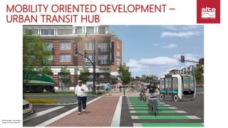
Design for Active + New Mobility
THE NEW TOD
Lisa Nisenson
New Mobility
@altaplanning
BIKE LANES
PEDESTRIAN
AMENITIES
INTERSECTION
DESIGN
MULTI-MODAL
TRAILS
BIKE SHARE
RESEARCH + TDM
PERFORMANCE &
MONITORING
WAYFINDING
PLACEMAKING &
CAMPUS DESIGN
ABOUT ALTA: INNOVATION LEADERS
BIKE LANES
PEDESTRIAN
AMENITIES
INTERSECTION
DESIGN
MULTI-MODAL
TRAILS
BIKE SHARE
RESEARCH/TDM
PERFORMANCE &
MONITORING
PLACEMAKING
WAYFINDING
TECHNOLOGY IS CHANGING CITIES
SHARED-USE MOBILITY
AUTONOMOUS VEHICLES
VEHICLE DESIGN
VIRTUAL/AUGMENTED REALITY
INTERNET OF THINGS
SEAMLESS PAYMENT & TRANSFERS
ENERGY SOURCES
DRONES & DELIVERY
SMART INFRASTRUCTURELocal Motors
Lyft
TransitScreen
One-Wheel
BIKE LANES
PEDESTRIAN
AMENITIES
INTERSECTION
DESIGN
MULTI-MODAL
TRAILS
BIKE SHARE
RESEARCH
PERFORMANCE &
MONITORING
PLACEMAKING
WAYFINDING
GUIDING IDEAS – FIRST CUT
DESIGNING FOR ACTIVE + NEW MOBILITY
DESIGN FOR ACTIVE, HEALTHY, CONNECTED PEOPLE &
PLACES
DESIGN FOR TRANSIT SYSTEMS, NOT INDIVIDUAL CARS
DEVELOP PLACE-BASED, SUSTAINABLE
TRANSPORTATION PORTFOLIOS
EXPECT, PLAN & GOVERN FOR FLEXIBILITY
EMBRACE TECHNOLOGY TO ENHANCE ACCESS FOR ALL
WHY A BIKE/PED-FIRST DESIGN AGENDA?
Walkable communities deliver multiple benefits
Cars get stuck in traffic – driver or not
People seeking experiences
Digital resilience – glitch happens
Can’t hack this! 
WHY A BIKE/PED-FIRST DESIGN AGENDA?
FACE IT: PEDS + AVs DON’T MIX WELL
The “1 Pedestrian & 1
Car” Illusion
People love to bully
robots
• David Woessner/Local Motors
“Trolley Problem”
WHY A BIKE/PED-FIRST AGENDA
FOR NEW MOBILITY? IT’S HERE..
Image: Navya
OPPORTUNITIES – BEYOND THE BULLSEYE
TOD model
Based on 1/2 mile walk
Access to stations
Service keyed to commutes
Drives real estate values
Image: Arlington County VA
BEYOND THE BULLSEYE: THE OCTOPUS
What’s Changing Now?
Better walk/bike connections
On-demand transit
Real time information/apps
Single payment cards
W-2 -> 1099 economy
Image: Robert Cervero, UC Berkeley
1998
2008
MOBILITY ORIENTED
DEVELOPMENT
Transit
• Move lots of people
NEW: Spines & Circulators
• Transit + Pedestrian Spine
• Parallel Spines
• Fixed route Circulators
• On-demand Circulators
• Hybrid Circulators
• Periphery
Image: Arlington County VA
Proving Ground
Local Demonstration
State Showcase
Private Campus
Residential Connections
Separated Transitway
Highway Tests
Business District Loop
Airport Shuttles
First/Last Miles
Districts:
Private &
Public Streets
Pilot
ProjectsTesting &
Demonstration
Projects
Transportation Hubs
High Speed Intercity
HOW WILL AUTONOMOUS ROLL OUT?
Big Jumps:
Riders/No Riders | Operator/No Operator | Private Streets to Public Streets
Image: Mobility E3
MOBILITY ORIENTED DEVELOPMENT –
URBAN TRANSIT HUB
Vehicle Image: Local Motors
Image: Omninet Properties
MOBILITY ORIENTED DEVELOPMENT
SUBURBAN RETROFIT
Vehicle Image: Local Motors
Image: Creative Commons/Paul Sableman
Arrowstreet Inc.
MOBILITY ORIENTED DEVELOPMENT
PHASING OUT PARKING
WHAT ABOUT TRANSIT?
TRANSIT IMPROVES
Shared use and AVs feed new customers to transit
Agencies operate their own AV fleets
TRANSIT FAILS
Weak systems lose ridership to on-demand & AVs
TRANSIT RESTRUCTURES
Agencies cede low performing routes
Focus on trunk lines/corridors
Engage AVs & shared-use as partners
TO-DO: BENEFITS / RISKS
#1 – Set Goals & Guiding Principles for New
Mobility & Community Design with the public
• Multi-Modal Streets – Don’t Forget the Basics
• What to Watch in Contracts & Revenue Replacement
• Candidates for Pilot Projects
• Shared Use – Transit/Paratransit
• Rethink Parking Garage & New Road Proposals NOW
Lisa Nisenson
Alta Planning + Design New
Mobility Group
@altaplanning
@nisenson
lisanisenson@altaplanning.com
Active, Healthy Community Design
Shared Use Mobility
Autonomous Vehicle Action Plans
Mobility Hubs
Street/Trail/Sidewalk Design
Wayfinding
Smart City Technology
Let’s Talk!

Tech & Transit Oriented Development - The New TOD

  • 1.
    Design for Active+ New Mobility THE NEW TOD Lisa Nisenson New Mobility @altaplanning
  • 2.
    BIKE LANES PEDESTRIAN AMENITIES INTERSECTION DESIGN MULTI-MODAL TRAILS BIKE SHARE RESEARCH+ TDM PERFORMANCE & MONITORING WAYFINDING PLACEMAKING & CAMPUS DESIGN ABOUT ALTA: INNOVATION LEADERS
  • 3.
    BIKE LANES PEDESTRIAN AMENITIES INTERSECTION DESIGN MULTI-MODAL TRAILS BIKE SHARE RESEARCH/TDM PERFORMANCE& MONITORING PLACEMAKING WAYFINDING TECHNOLOGY IS CHANGING CITIES SHARED-USE MOBILITY AUTONOMOUS VEHICLES VEHICLE DESIGN VIRTUAL/AUGMENTED REALITY INTERNET OF THINGS SEAMLESS PAYMENT & TRANSFERS ENERGY SOURCES DRONES & DELIVERY SMART INFRASTRUCTURELocal Motors Lyft TransitScreen One-Wheel
  • 4.
    BIKE LANES PEDESTRIAN AMENITIES INTERSECTION DESIGN MULTI-MODAL TRAILS BIKE SHARE RESEARCH PERFORMANCE& MONITORING PLACEMAKING WAYFINDING GUIDING IDEAS – FIRST CUT DESIGNING FOR ACTIVE + NEW MOBILITY DESIGN FOR ACTIVE, HEALTHY, CONNECTED PEOPLE & PLACES DESIGN FOR TRANSIT SYSTEMS, NOT INDIVIDUAL CARS DEVELOP PLACE-BASED, SUSTAINABLE TRANSPORTATION PORTFOLIOS EXPECT, PLAN & GOVERN FOR FLEXIBILITY EMBRACE TECHNOLOGY TO ENHANCE ACCESS FOR ALL
  • 5.
    WHY A BIKE/PED-FIRSTDESIGN AGENDA? Walkable communities deliver multiple benefits Cars get stuck in traffic – driver or not People seeking experiences Digital resilience – glitch happens Can’t hack this! 
  • 6.
    WHY A BIKE/PED-FIRSTDESIGN AGENDA? FACE IT: PEDS + AVs DON’T MIX WELL The “1 Pedestrian & 1 Car” Illusion People love to bully robots • David Woessner/Local Motors “Trolley Problem”
  • 7.
    WHY A BIKE/PED-FIRSTAGENDA FOR NEW MOBILITY? IT’S HERE.. Image: Navya
  • 8.
    OPPORTUNITIES – BEYONDTHE BULLSEYE TOD model Based on 1/2 mile walk Access to stations Service keyed to commutes Drives real estate values Image: Arlington County VA
  • 9.
    BEYOND THE BULLSEYE:THE OCTOPUS What’s Changing Now? Better walk/bike connections On-demand transit Real time information/apps Single payment cards W-2 -> 1099 economy Image: Robert Cervero, UC Berkeley 1998 2008
  • 10.
    MOBILITY ORIENTED DEVELOPMENT Transit • Movelots of people NEW: Spines & Circulators • Transit + Pedestrian Spine • Parallel Spines • Fixed route Circulators • On-demand Circulators • Hybrid Circulators • Periphery Image: Arlington County VA
  • 11.
    Proving Ground Local Demonstration StateShowcase Private Campus Residential Connections Separated Transitway Highway Tests Business District Loop Airport Shuttles First/Last Miles Districts: Private & Public Streets Pilot ProjectsTesting & Demonstration Projects Transportation Hubs High Speed Intercity HOW WILL AUTONOMOUS ROLL OUT? Big Jumps: Riders/No Riders | Operator/No Operator | Private Streets to Public Streets Image: Mobility E3
  • 12.
    MOBILITY ORIENTED DEVELOPMENT– URBAN TRANSIT HUB Vehicle Image: Local Motors Image: Omninet Properties
  • 13.
    MOBILITY ORIENTED DEVELOPMENT SUBURBANRETROFIT Vehicle Image: Local Motors Image: Creative Commons/Paul Sableman
  • 14.
    Arrowstreet Inc. MOBILITY ORIENTEDDEVELOPMENT PHASING OUT PARKING
  • 15.
    WHAT ABOUT TRANSIT? TRANSITIMPROVES Shared use and AVs feed new customers to transit Agencies operate their own AV fleets TRANSIT FAILS Weak systems lose ridership to on-demand & AVs TRANSIT RESTRUCTURES Agencies cede low performing routes Focus on trunk lines/corridors Engage AVs & shared-use as partners
  • 16.
    TO-DO: BENEFITS /RISKS #1 – Set Goals & Guiding Principles for New Mobility & Community Design with the public • Multi-Modal Streets – Don’t Forget the Basics • What to Watch in Contracts & Revenue Replacement • Candidates for Pilot Projects • Shared Use – Transit/Paratransit • Rethink Parking Garage & New Road Proposals NOW
  • 17.
    Lisa Nisenson Alta Planning+ Design New Mobility Group @altaplanning @nisenson lisanisenson@altaplanning.com Active, Healthy Community Design Shared Use Mobility Autonomous Vehicle Action Plans Mobility Hubs Street/Trail/Sidewalk Design Wayfinding Smart City Technology Let’s Talk!

Editor's Notes

  • #7 Most scenarios of pedestrian safety allude to one car and one pedestrian. However 50 cars and 60 pedestrians is a recipe for gridlock. If one car stops then all others behind need to stop as well. Then there is the problem of pedestrians “gaming” cars. Finally there is the “trolley” problem, which in this case is a baby carriage. Carmakers are having to provide tradeoff algorithms, which proves that the safety is not foolproof. In the end, we will either need to (1) highly regulate pedestrians, making walking less attractive, or (2) limit conflicts.
  • #8 Las Vegas launched this driverless shuttle on public streets in December.
  • #9 Let’s talk Transit Oriented Development. The current model is a “bulls-eye” where development is concentration around stations, with the highest density at locations closes to station entrances.
  • #10 Technology is already changing the shape of TOD-sheds. In this example, access to station is not spreading out along enhanced bike and walk routes. RCLCO has also found that demand for TOD is spreading to areas where access is a $5 or less Uber/Lyft ride. In addition real time information and seamless payment systems make transit easier, predictable and thus more attractive
  • #11 Autonomous will help us move to even more access. First – high capacity transit will always be a requirement to move a lot of people. There is simply not enough road capacity to handle individual cars. Second, to limit conflicts among active and autonomous modes, we can build spines for bike, peds and autonomous shuttles Autonomous cars and deliveries can access the TOD at the periphery. Automated delivery internally can then deliver goods. Autonomous shuttles can provide access to transit for neighborhoods now isolated by distance or geography.