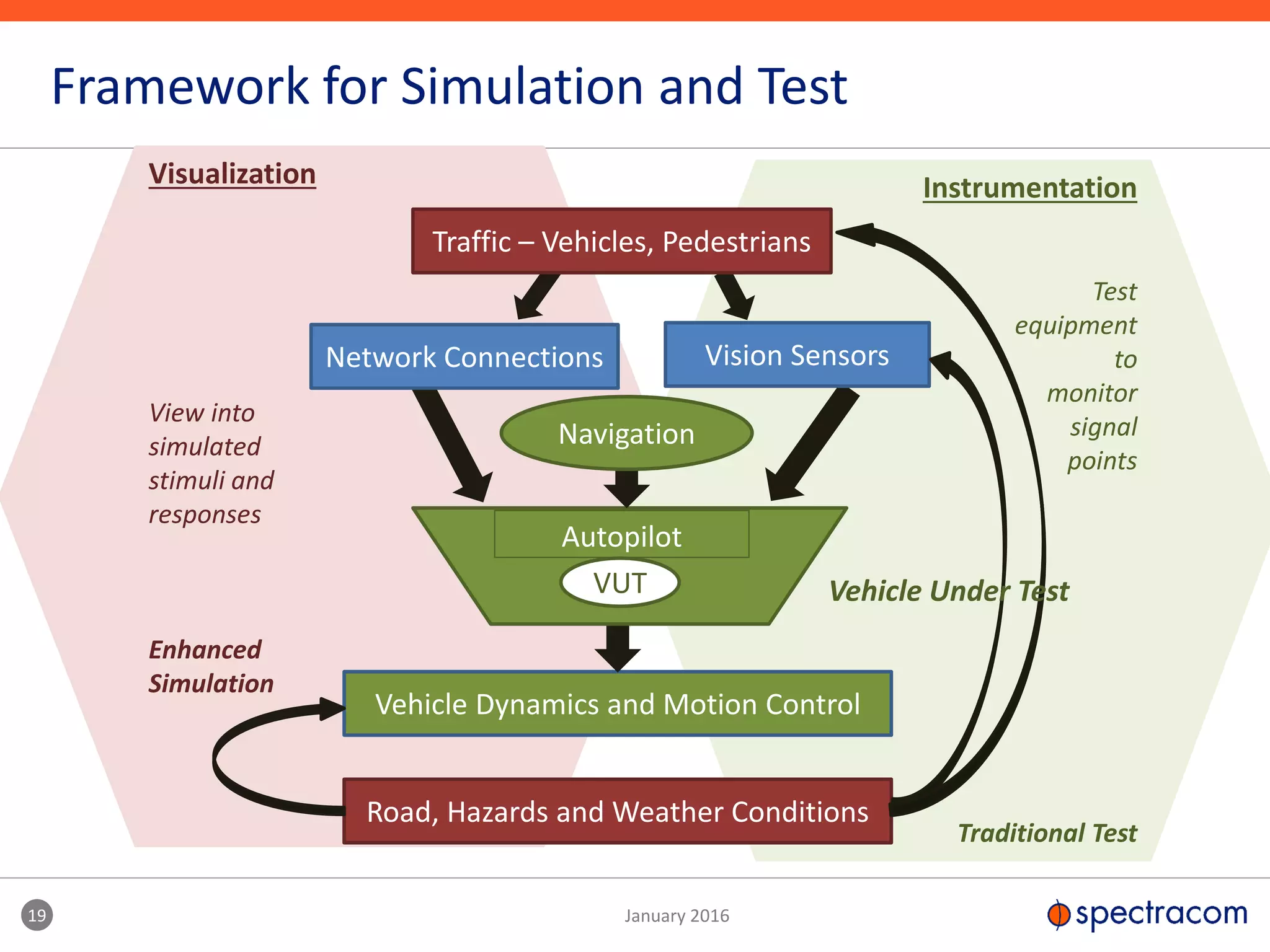
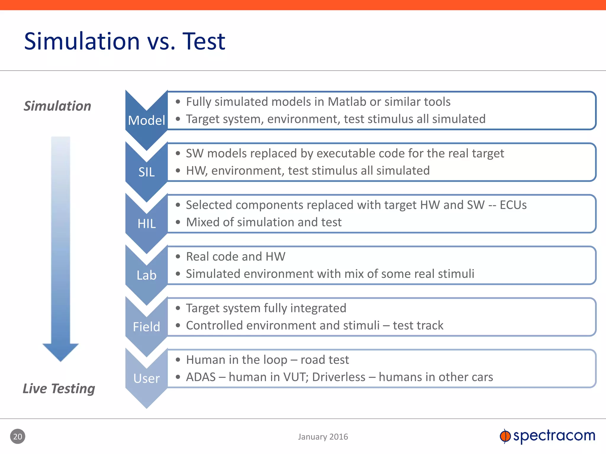
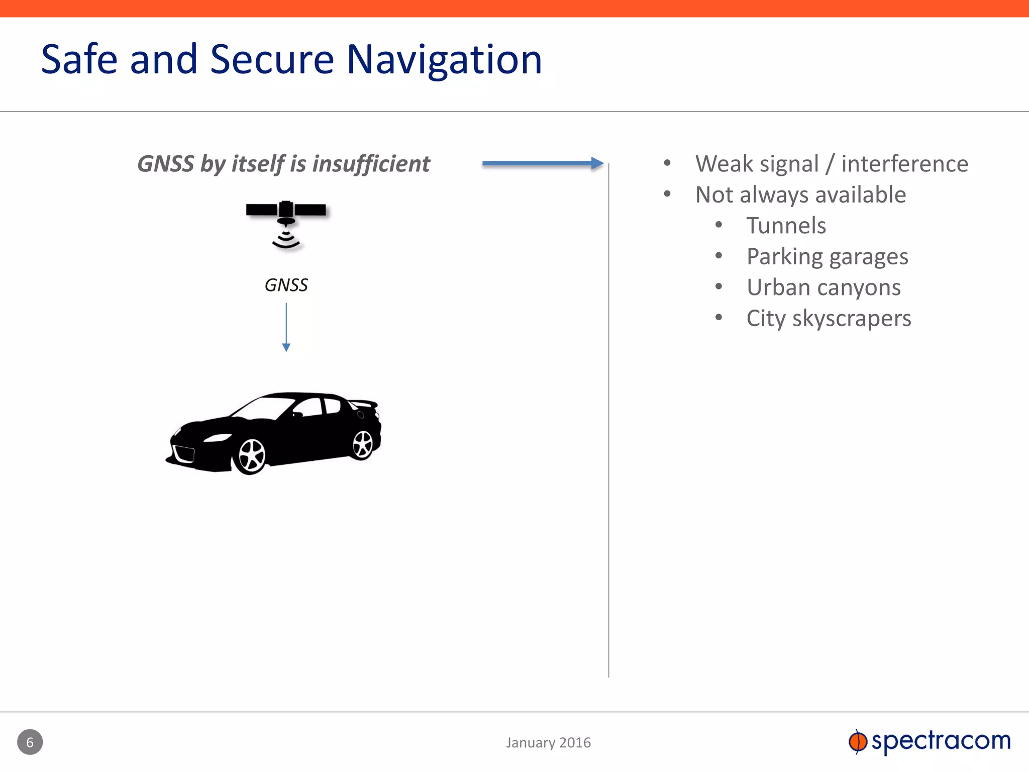
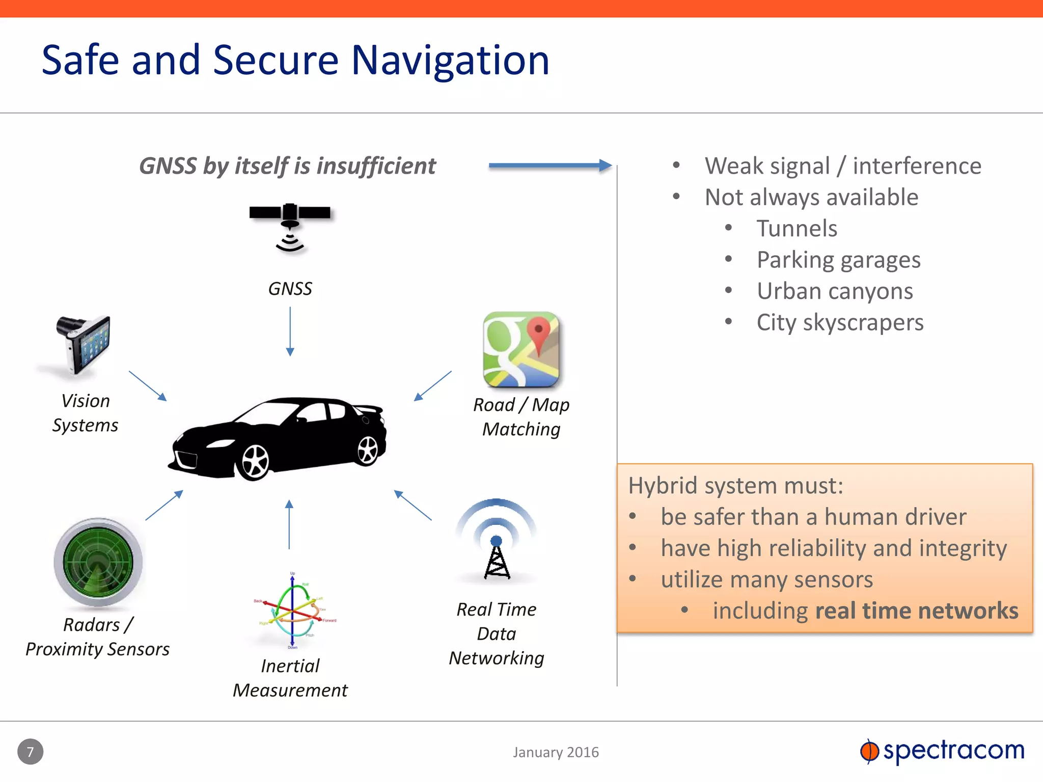
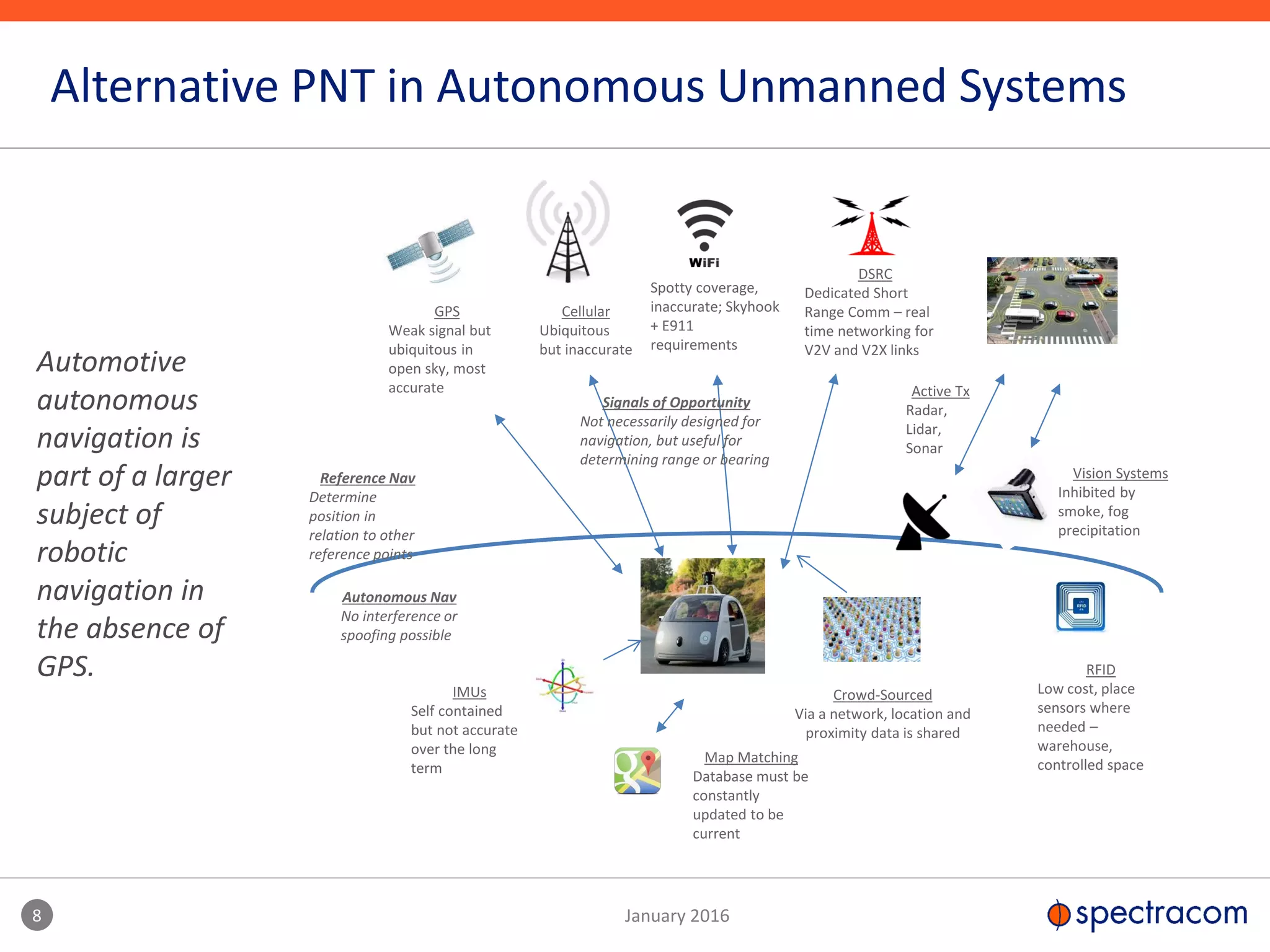
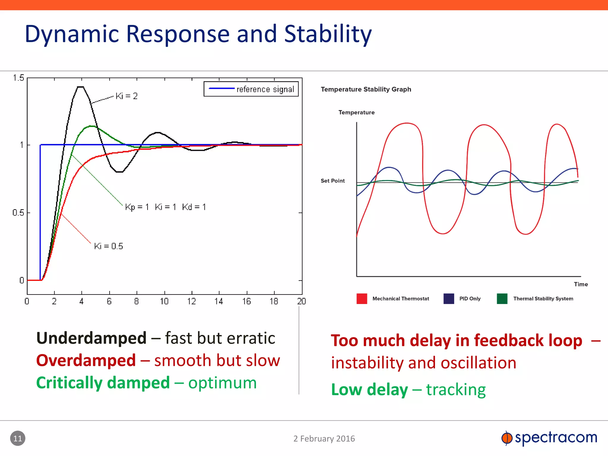
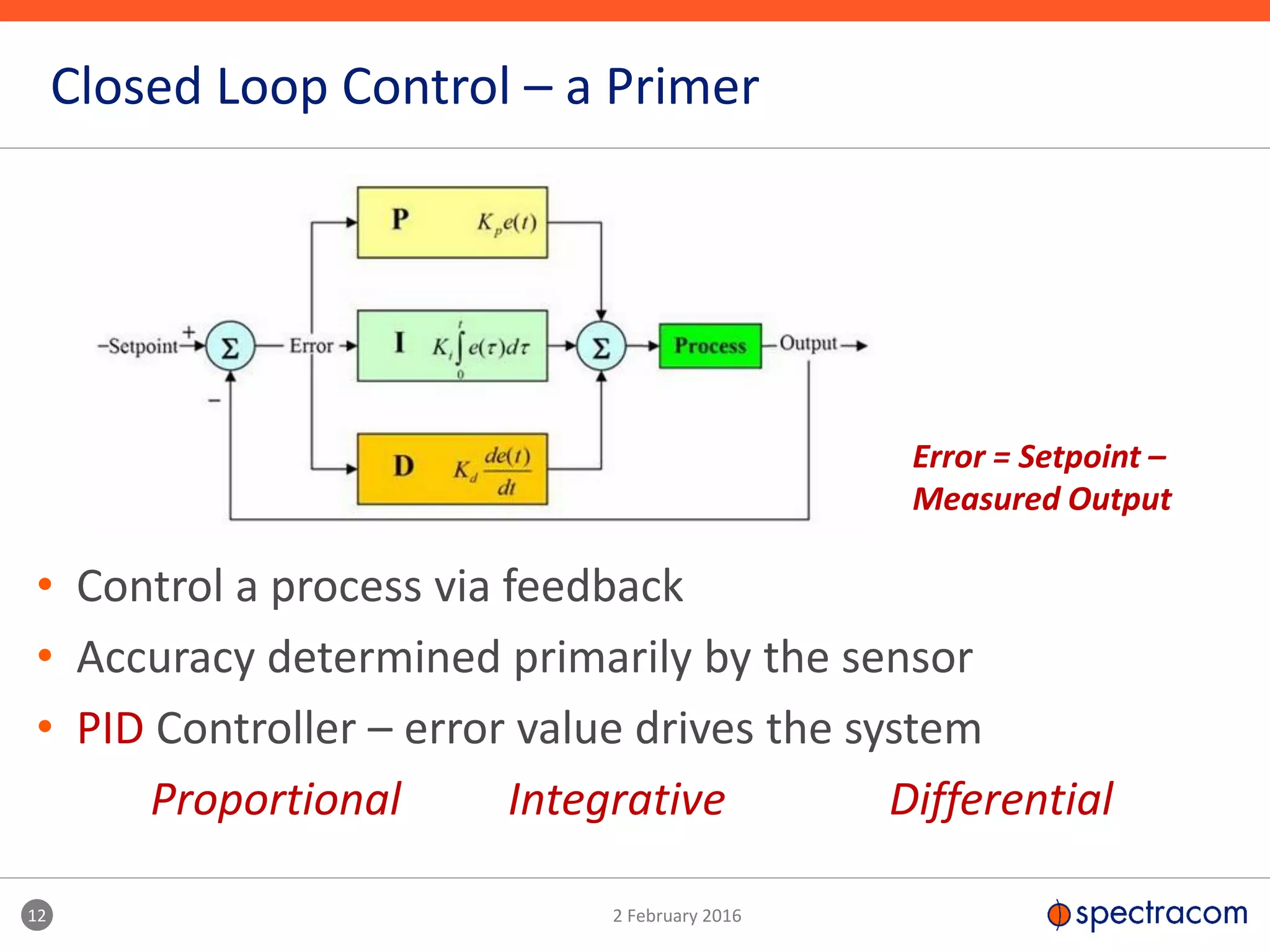
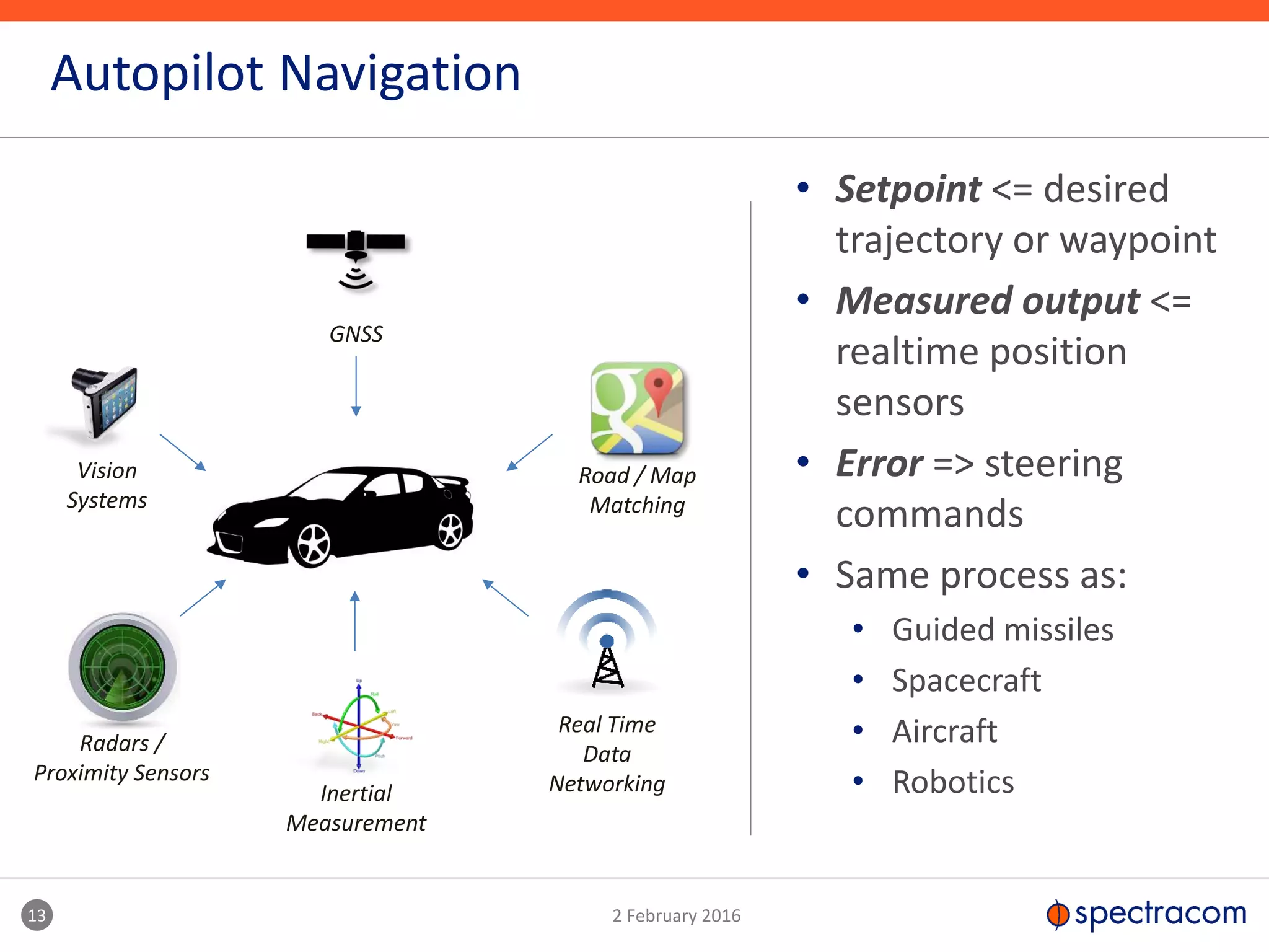
The Importance of Timing to
Autonomous Vehicle Navigation
John Fischer, CTO
jfischer@spectracom.com
2 January 2016
Spectracom: Precise, Secure, Synchronized
Bringing Technology to:
 Military, Aerospace
 UAV’s
 Electronic Warfare
 C4ISR
 High-End Commercial Apps
 Datacenters
 Robotics/Telematics
 IDM
 GIS Data Mining
Spectracom simplifies Position, Navigation, and Timing integration
into our customer’s systems.
3 January 2016
Global Organization
3
Multi-domestic strategy
100+ Employees in 6 countries
High reliability and superior service
All sites ISO 9001 Registered
USA
Brazil
UK
France
Russia
China
• ADAS already in luxury cars and moving to mainstream
• Anti-lock brakes and anti-slip traction control
• Lane departure warning system
• Speed assistance and autonomous emergency braking
• Automatic parking
• Driver wake-up and attention control
• Pedestrian and low-speed obstacle avoidance
Advanced Driver Assisted Systems
4 January 2016
• Mix of correlated sensors for
navigation
• Radar and proximity sensing
• Optical, vision systems
• GNSS
• Accurate map matching
• New regulations for safety
• Four US states have laws for
autonomous vehicles on public roads
• Google – over 1 million miles tested
• UK -2013 – testing on public roads
• France – 2015 – 2000 km roads for
testing – Peugeot-Citroen
• Toyota Lexus GS autonomous car on
Tokyo expressways
• Canada – starting 2016 testing
5 January 2016
ADAS -> Driverless Car
6 January 2016
Safe and Secure Navigation
GNSS
GNSS by itself is insufficient • Weak signal / interference
• Not always available
• Tunnels
• Parking garages
• Urban canyons
• City skyscrapers
7 January 2016
Safe and Secure Navigation
GNSS
Vision
Systems
Radars /
Proximity Sensors
Inertial
Measurement
Road / Map
Matching
Real Time
Data
Networking
GNSS by itself is insufficient
Hybrid system must:
• be safer than a human driver
• have high reliability and integrity
• utilize many sensors
• including real time networks
• Weak signal / interference
• Not always available
• Tunnels
• Parking garages
• Urban canyons
• City skyscrapers
Map Matching
Database must be
constantly
updated to be
current
IMUs
Self contained
but not accurate
over the long
term
Autonomous Nav
No interference or
spoofing possible
Reference Nav
Determine
position in
relation to other
reference points
GPS
Weak signal but
ubiquitous in
open sky, most
accurate
Vision Systems
Inhibited by
smoke, fog
precipitation
Spotty coverage,
inaccurate; Skyhook
+ E911
requirements
Cellular
Ubiquitous
but inaccurate
RFID
Low cost, place
sensors where
needed –
warehouse,
controlled space
Active Tx
Radar,
Lidar,
Sonar
Crowd-Sourced
Via a network, location and
proximity data is shared
Signals of Opportunity
Not necessarily designed for
navigation, but useful for
determining range or bearing
DSRC
Dedicated Short
Range Comm – real
time networking for
V2V and V2X links
8 January 2016
Alternative PNT in Autonomous Unmanned Systems
Automotive
autonomous
navigation is
part of a larger
subject of
robotic
navigation in
the absence of
GPS.
Autopilot Systems
from
Guided Missiles and Spacecraft
to
UAVs and Driverless Car
over 50 years of Technology Advancement
9 January 2016
10 January 2016
Autopilot Example – Cruise Control
Automatically maintain a set speed
Underdamped – fast but erratic
Overdamped – smooth but slow
Critically damped – optimum
11 2 February 2016
Dynamic Response and Stability
Too much delay in feedback loop –
instability and oscillation
Low delay – tracking
12 2 February 2016
Closed Loop Control – a Primer
• Control a process via feedback
• Accuracy determined primarily by the sensor
• PID Controller – error value drives the system
Proportional Integrative Differential
Error = Setpoint –
Measured Output
• Setpoint <= desired
trajectory or waypoint
• Measured output <=
realtime position
sensors
• Error => steering
commands
• Same process as:
• Guided missiles
• Spacecraft
• Aircraft
• Robotics
13 2 February 2016
Autopilot Navigation
GNSS
Vision
Systems
Radars /
Proximity Sensors
Inertial
Measurement
Road / Map
Matching
Real Time
Data
Networking
The Connected Car
the network as part of the autopilot navigation system
14 January 2016
15 January 2016
V2X Communications
• V2V – Vehicle to Vehicle
• V2I – Vehicle to Infrastructure
V2X communications integrated with navigation system can increase safety greatly
1. Real time data network
• Traffic lights
• Emergency vehicles
• Construction zones
2. Coordination / early warning
• Advanced braking
• Platooning
3. “Crowd-sourced” location
• Shared location
• Proximity detection
DSRC – Dedicated Short Range Communications
16 January 2016
The Connected Car –Two Separate Networks
Real Time /
Critical
Connectivity
Non-Real Time /
User Experience
Connectivity
where every millisecond matters where a few seconds is ok
Navigation
Internet, Infotainment,
Telematics, etc.
cellular
DSRC
• Low latency
• Predictable latency
• Reduce worst case delays
• Priority scheduling/pre-emption
• Instant switching to alternate
paths
• Ensure delivery
• Reliable for critical operations
• Under fading conditions
• Congestion and Doppler
• Fault tolerance and redundancy
• Security and Privacy
• Time delay implies distance
• Regulatory compliance
• Scalable to larger networks
17 January 2016
Time Sensitive Network Issues
IEEE Network Specs
802.11p – Wireless Vehicles
[DSRC]
802.1AS – Time Sync
1588v2 – Precise Time Protocol
802.1Qac – Path Control
802.1Qbv – Scheduled Traffic
802.1Qbu – Pre-emption
802.1Qca – Path Control
802.1Qcb – Seamless Redundant
802.11Qcc – Stream Reservation
802.11Qci – Filtering and Policing
802.11Qv – Time Mgmt Protocol
18 January 2016
Time Sensitivity for Automotive Networks
Let’s do the numbers [Order of Magnitude]
• 60 mph => 100 km/hr
30 m/s => 3 cm/millisecond
• System level response => msec
=> 1KHz update rates minimum
• Subsystem responses =>
10 – 100 usec range
• Network latency =>
< 100 usec over multiple hops [5-7]
• alternate fault tolerant paths
• all Bit Error Rate [BER] conditions
Latency is key if the network is part of the control loop:
• Stability
• Dynamic performance
19 January 2016
Framework for Simulation and Test
Visualization
View into
simulated
stimuli and
responses
Enhanced
Simulation
Instrumentation
Test
equipment
to
monitor
signal
points
Traditional Test
Vision SensorsNetwork Connections
Vehicle Dynamics and Motion Control
Road, Hazards and Weather Conditions
Autopilot
VUT
Navigation
Traffic – Vehicles, Pedestrians
Vehicle Under Test
20 January 2016
Simulation vs. Test
Model
• Fully simulated models in Matlab or similar tools
• Target system, environment, test stimulus all simulated
SIL
• SW models replaced by executable code for the real target
• HW, environment, test stimulus all simulated
HIL
• Selected components replaced with target HW and SW -- ECUs
• Mixed of simulation and test
Lab
• Real code and HW
• Simulated environment with mix of some real stimuli
Field
• Target system fully integrated
• Controlled environment and stimuli – test track
User
• Human in the loop – road test
• ADAS – human in VUT; Driverless – humans in other cars
Simulation
Live Testing
• Driver assisted and driverless cars are here today…
• …requiring very complex navigation systems
• Much more than just GNSS
• INS, mapping, radars, vision systems, realtime networks
• Simulation and Test must address interaction effects in
complex control loops
• Traffic and road conditions, objects, weather
• Wireless network latency a key factor in the control
system
• Fault tolerance, route changes, re-transmission, multiple hops
• Time Sensitive Networks
Summary
21 January 2016
• Hiro Sasaki – Director, Architected Solutions
• hsasaki@spectracom.com
• Lisa Perdue – GNSS Systems
• lperdue@spectracom.com
• Gilles Boime – Senior Scientist
• gboime@spectracom.com
• Emmanuel Sicsik-Pare -- Strategic Product Mgr
• Emmanuel.sicsik-pare@spectracom.orolia.com
• John Fischer - CTO
• jfischer@spectracom.com
Acknowledgements
22 January 2016

The Importance of Timing to Autonomous Vehicle Navigation

  • 1.
    The Importance ofTiming to Autonomous Vehicle Navigation John Fischer, CTO jfischer@spectracom.com
  • 2.
    2 January 2016 Spectracom:Precise, Secure, Synchronized Bringing Technology to:  Military, Aerospace  UAV’s  Electronic Warfare  C4ISR  High-End Commercial Apps  Datacenters  Robotics/Telematics  IDM  GIS Data Mining Spectracom simplifies Position, Navigation, and Timing integration into our customer’s systems.
  • 3.
    3 January 2016 GlobalOrganization 3 Multi-domestic strategy 100+ Employees in 6 countries High reliability and superior service All sites ISO 9001 Registered USA Brazil UK France Russia China
  • 4.
    • ADAS alreadyin luxury cars and moving to mainstream • Anti-lock brakes and anti-slip traction control • Lane departure warning system • Speed assistance and autonomous emergency braking • Automatic parking • Driver wake-up and attention control • Pedestrian and low-speed obstacle avoidance Advanced Driver Assisted Systems 4 January 2016
  • 5.
    • Mix ofcorrelated sensors for navigation • Radar and proximity sensing • Optical, vision systems • GNSS • Accurate map matching • New regulations for safety • Four US states have laws for autonomous vehicles on public roads • Google – over 1 million miles tested • UK -2013 – testing on public roads • France – 2015 – 2000 km roads for testing – Peugeot-Citroen • Toyota Lexus GS autonomous car on Tokyo expressways • Canada – starting 2016 testing 5 January 2016 ADAS -> Driverless Car
  • 6.
    6 January 2016 Safeand Secure Navigation GNSS GNSS by itself is insufficient • Weak signal / interference • Not always available • Tunnels • Parking garages • Urban canyons • City skyscrapers
  • 7.
    7 January 2016 Safeand Secure Navigation GNSS Vision Systems Radars / Proximity Sensors Inertial Measurement Road / Map Matching Real Time Data Networking GNSS by itself is insufficient Hybrid system must: • be safer than a human driver • have high reliability and integrity • utilize many sensors • including real time networks • Weak signal / interference • Not always available • Tunnels • Parking garages • Urban canyons • City skyscrapers
  • 8.
    Map Matching Database mustbe constantly updated to be current IMUs Self contained but not accurate over the long term Autonomous Nav No interference or spoofing possible Reference Nav Determine position in relation to other reference points GPS Weak signal but ubiquitous in open sky, most accurate Vision Systems Inhibited by smoke, fog precipitation Spotty coverage, inaccurate; Skyhook + E911 requirements Cellular Ubiquitous but inaccurate RFID Low cost, place sensors where needed – warehouse, controlled space Active Tx Radar, Lidar, Sonar Crowd-Sourced Via a network, location and proximity data is shared Signals of Opportunity Not necessarily designed for navigation, but useful for determining range or bearing DSRC Dedicated Short Range Comm – real time networking for V2V and V2X links 8 January 2016 Alternative PNT in Autonomous Unmanned Systems Automotive autonomous navigation is part of a larger subject of robotic navigation in the absence of GPS.
  • 9.
    Autopilot Systems from Guided Missilesand Spacecraft to UAVs and Driverless Car over 50 years of Technology Advancement 9 January 2016
  • 10.
    10 January 2016 AutopilotExample – Cruise Control Automatically maintain a set speed
  • 11.
    Underdamped – fastbut erratic Overdamped – smooth but slow Critically damped – optimum 11 2 February 2016 Dynamic Response and Stability Too much delay in feedback loop – instability and oscillation Low delay – tracking
  • 12.
    12 2 February2016 Closed Loop Control – a Primer • Control a process via feedback • Accuracy determined primarily by the sensor • PID Controller – error value drives the system Proportional Integrative Differential Error = Setpoint – Measured Output
  • 13.
    • Setpoint <=desired trajectory or waypoint • Measured output <= realtime position sensors • Error => steering commands • Same process as: • Guided missiles • Spacecraft • Aircraft • Robotics 13 2 February 2016 Autopilot Navigation GNSS Vision Systems Radars / Proximity Sensors Inertial Measurement Road / Map Matching Real Time Data Networking
  • 14.
    The Connected Car thenetwork as part of the autopilot navigation system 14 January 2016
  • 15.
    15 January 2016 V2XCommunications • V2V – Vehicle to Vehicle • V2I – Vehicle to Infrastructure V2X communications integrated with navigation system can increase safety greatly 1. Real time data network • Traffic lights • Emergency vehicles • Construction zones 2. Coordination / early warning • Advanced braking • Platooning 3. “Crowd-sourced” location • Shared location • Proximity detection DSRC – Dedicated Short Range Communications
  • 16.
    16 January 2016 TheConnected Car –Two Separate Networks Real Time / Critical Connectivity Non-Real Time / User Experience Connectivity where every millisecond matters where a few seconds is ok Navigation Internet, Infotainment, Telematics, etc. cellular DSRC
  • 17.
    • Low latency •Predictable latency • Reduce worst case delays • Priority scheduling/pre-emption • Instant switching to alternate paths • Ensure delivery • Reliable for critical operations • Under fading conditions • Congestion and Doppler • Fault tolerance and redundancy • Security and Privacy • Time delay implies distance • Regulatory compliance • Scalable to larger networks 17 January 2016 Time Sensitive Network Issues IEEE Network Specs 802.11p – Wireless Vehicles [DSRC] 802.1AS – Time Sync 1588v2 – Precise Time Protocol 802.1Qac – Path Control 802.1Qbv – Scheduled Traffic 802.1Qbu – Pre-emption 802.1Qca – Path Control 802.1Qcb – Seamless Redundant 802.11Qcc – Stream Reservation 802.11Qci – Filtering and Policing 802.11Qv – Time Mgmt Protocol
  • 18.
    18 January 2016 TimeSensitivity for Automotive Networks Let’s do the numbers [Order of Magnitude] • 60 mph => 100 km/hr 30 m/s => 3 cm/millisecond • System level response => msec => 1KHz update rates minimum • Subsystem responses => 10 – 100 usec range • Network latency => < 100 usec over multiple hops [5-7] • alternate fault tolerant paths • all Bit Error Rate [BER] conditions Latency is key if the network is part of the control loop: • Stability • Dynamic performance
  • 19.
    19 January 2016 Frameworkfor Simulation and Test Visualization View into simulated stimuli and responses Enhanced Simulation Instrumentation Test equipment to monitor signal points Traditional Test Vision SensorsNetwork Connections Vehicle Dynamics and Motion Control Road, Hazards and Weather Conditions Autopilot VUT Navigation Traffic – Vehicles, Pedestrians Vehicle Under Test
  • 20.
    20 January 2016 Simulationvs. Test Model • Fully simulated models in Matlab or similar tools • Target system, environment, test stimulus all simulated SIL • SW models replaced by executable code for the real target • HW, environment, test stimulus all simulated HIL • Selected components replaced with target HW and SW -- ECUs • Mixed of simulation and test Lab • Real code and HW • Simulated environment with mix of some real stimuli Field • Target system fully integrated • Controlled environment and stimuli – test track User • Human in the loop – road test • ADAS – human in VUT; Driverless – humans in other cars Simulation Live Testing
  • 21.
    • Driver assistedand driverless cars are here today… • …requiring very complex navigation systems • Much more than just GNSS • INS, mapping, radars, vision systems, realtime networks • Simulation and Test must address interaction effects in complex control loops • Traffic and road conditions, objects, weather • Wireless network latency a key factor in the control system • Fault tolerance, route changes, re-transmission, multiple hops • Time Sensitive Networks Summary 21 January 2016
  • 22.
    • Hiro Sasaki– Director, Architected Solutions • hsasaki@spectracom.com • Lisa Perdue – GNSS Systems • lperdue@spectracom.com • Gilles Boime – Senior Scientist • gboime@spectracom.com • Emmanuel Sicsik-Pare -- Strategic Product Mgr • Emmanuel.sicsik-pare@spectracom.orolia.com • John Fischer - CTO • jfischer@spectracom.com Acknowledgements 22 January 2016