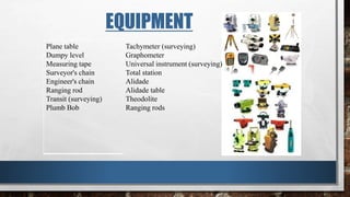
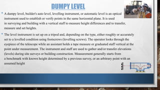
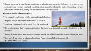
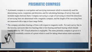
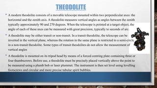
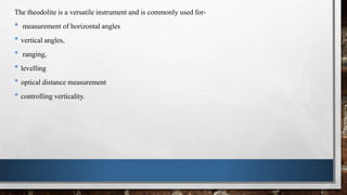
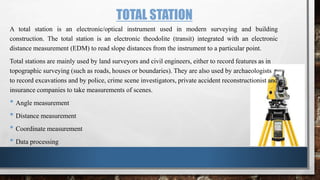
This document discusses various surveying instruments used for setting out engineering works. It describes the importance of setting out works, which involves transferring distances from plans to mark locations before construction. Key instruments discussed include dumpy levels, prismatic compasses, theodolites, and total stations. Dumpy levels are used to establish horizontal planes and measure height differences, while theodolites and total stations can measure both horizontal and vertical angles for layout. Total stations integrate electronic distance measurement with a theodolite for coordinate measurement. Maintaining accuracy is essential for setting out works.
Metric Chain : It Consists of galvanized mild steel wire of 4mm diameter known as link.
It is available in 20m, 30m, 50m length which consists of 100 links.
Gunter’s Chain : A 66 feet long chain consists of 100 links, each of 0.66 feet, it is known as Gunter’s chain.
This chain is suitable for taking length in miles.
Engineer’s Chain : A 100 feet long chain consisting of 100 links each of 1 feet is known as engineer’s chain.
This chain is used to measure length in feet and area in sq.yard.
Revenue Chain : it is 33 feet long chain consisting of 16 links.
This chain is used for distance measurements in feet & inches for smaller areas.
Introduction, purpose, principle, instruments, methods of tacheometry, stadia constants, anallatic lens, Subtense bar, field work in tacheometry, reduction of readings, errors and precisions.
In this lecture we will cover
Applications of levelling
Equipment and procedures
Purposes of levelling
Some definitions
Applications
Longitudinal sections and cross sections
Plotting the profile
Procedure of profile
Procedure of cross-section:
Plotting the cross-section:
Prepared by:
Asst. Prof. Salar K.Hussein
Mr. Kamal Y.Abdullah
Asst.Lecturer. Dilveen H. Omar
Erbil Polytechnic University
Technical Engineering College
Civil Engineering Department
What is a Total Station?
Capability of a Total Station
Important Operations of Total Station
Uses of Total Station
Advantages of Using Total Stations
Applications
This ppt presentation covers compass surveying, which explains principal of compass surveying, Types of compass, Difference between compass, Bearing, Definitions related to compass surveying etc.
Conventional and modern surveying instrumentssameedaslam
Instruments have a major importance in the field of survey. There are numerous instruments which are used in surveying.With the passage of time instruments have been modified and more accurate.
The science of today is the technology of tomorrow.
About
Indigenized remote control interface card suitable for MAFI system CCR equipment. Compatible for IDM8000 CCR. Backplane mounted serial and TCP/Ethernet communication module for CCR remote access. IDM 8000 CCR remote control on serial and TCP protocol.
• Remote control: Parallel or serial interface.
• Compatible with MAFI CCR system.
• Compatible with IDM8000 CCR.
• Compatible with Backplane mount serial communication.
• Compatible with commercial and Defence aviation CCR system.
• Remote control system for accessing CCR and allied system over serial or TCP.
• Indigenized local Support/presence in India.
• Easy in configuration using DIP switches.
Technical Specifications
Indigenized remote control interface card suitable for MAFI system CCR equipment. Compatible for IDM8000 CCR. Backplane mounted serial and TCP/Ethernet communication module for CCR remote access. IDM 8000 CCR remote control on serial and TCP protocol.
Key Features
Indigenized remote control interface card suitable for MAFI system CCR equipment. Compatible for IDM8000 CCR. Backplane mounted serial and TCP/Ethernet communication module for CCR remote access. IDM 8000 CCR remote control on serial and TCP protocol.
• Remote control: Parallel or serial interface
• Compatible with MAFI CCR system
• Copatiable with IDM8000 CCR
• Compatible with Backplane mount serial communication.
• Compatible with commercial and Defence aviation CCR system.
• Remote control system for accessing CCR and allied system over serial or TCP.
• Indigenized local Support/presence in India.
Application
• Remote control: Parallel or serial interface.
• Compatible with MAFI CCR system.
• Compatible with IDM8000 CCR.
• Compatible with Backplane mount serial communication.
• Compatible with commercial and Defence aviation CCR system.
• Remote control system for accessing CCR and allied system over serial or TCP.
• Indigenized local Support/presence in India.
• Easy in configuration using DIP switches.
Overview of the fundamental roles in Hydropower generation and the components involved in wider Electrical Engineering.
This paper presents the design and construction of hydroelectric dams from the hydrologist’s survey of the valley before construction, all aspects and involved disciplines, fluid dynamics, structural engineering, generation and mains frequency regulation to the very transmission of power through the network in the United Kingdom.
Author: Robbie Edward Sayers
Collaborators and co editors: Charlie Sims and Connor Healey.
(C) 2024 Robbie E. Sayers
Hybrid optimization of pumped hydro system and solar- Engr. Abdul-Azeez.pdffxintegritypublishin
Advancements in technology unveil a myriad of electrical and electronic breakthroughs geared towards efficiently harnessing limited resources to meet human energy demands. The optimization of hybrid solar PV panels and pumped hydro energy supply systems plays a pivotal role in utilizing natural resources effectively. This initiative not only benefits humanity but also fosters environmental sustainability. The study investigated the design optimization of these hybrid systems, focusing on understanding solar radiation patterns, identifying geographical influences on solar radiation, formulating a mathematical model for system optimization, and determining the optimal configuration of PV panels and pumped hydro storage. Through a comparative analysis approach and eight weeks of data collection, the study addressed key research questions related to solar radiation patterns and optimal system design. The findings highlighted regions with heightened solar radiation levels, showcasing substantial potential for power generation and emphasizing the system's efficiency. Optimizing system design significantly boosted power generation, promoted renewable energy utilization, and enhanced energy storage capacity. The study underscored the benefits of optimizing hybrid solar PV panels and pumped hydro energy supply systems for sustainable energy usage. Optimizing the design of solar PV panels and pumped hydro energy supply systems as examined across diverse climatic conditions in a developing country, not only enhances power generation but also improves the integration of renewable energy sources and boosts energy storage capacities, particularly beneficial for less economically prosperous regions. Additionally, the study provides valuable insights for advancing energy research in economically viable areas. Recommendations included conducting site-specific assessments, utilizing advanced modeling tools, implementing regular maintenance protocols, and enhancing communication among system components.
Democratizing Fuzzing at Scale by Abhishek Aryaabh.arya
Presented at NUS: Fuzzing and Software Security Summer School 2024
This keynote talks about the democratization of fuzzing at scale, highlighting the collaboration between open source communities, academia, and industry to advance the field of fuzzing. It delves into the history of fuzzing, the development of scalable fuzzing platforms, and the empowerment of community-driven research. The talk will further discuss recent advancements leveraging AI/ML and offer insights into the future evolution of the fuzzing landscape.
TECHNICAL TRAINING MANUAL GENERAL FAMILIARIZATION COURSEDuvanRamosGarzon1
AIRCRAFT GENERAL
The Single Aisle is the most advanced family aircraft in service today, with fly-by-wire flight controls.
The A318, A319, A320 and A321 are twin-engine subsonic medium range aircraft.
The family offers a choice of engines
Welcome to WIPAC Monthly the magazine brought to you by the LinkedIn Group Water Industry Process Automation & Control.
In this month's edition, along with this month's industry news to celebrate the 13 years since the group was created we have articles including
A case study of the used of Advanced Process Control at the Wastewater Treatment works at Lleida in Spain
A look back on an article on smart wastewater networks in order to see how the industry has measured up in the interim around the adoption of Digital Transformation in the Water Industry.
COLLEGE BUS MANAGEMENT SYSTEM PROJECT REPORT.pdfKamal Acharya
The College Bus Management system is completely developed by Visual Basic .NET Version. The application is connect with most secured database language MS SQL Server. The application is develop by using best combination of front-end and back-end languages. The application is totally design like flat user interface. This flat user interface is more attractive user interface in 2017. The application is gives more important to the system functionality. The application is to manage the student’s details, driver’s details, bus details, bus route details, bus fees details and more. The application has only one unit for admin. The admin can manage the entire application. The admin can login into the application by using username and password of the admin. The application is develop for big and small colleges. It is more user friendly for non-computer person. Even they can easily learn how to manage the application within hours. The application is more secure by the admin. The system will give an effective output for the VB.Net and SQL Server given as input to the system. The compiled java program given as input to the system, after scanning the program will generate different reports. The application generates the report for users. The admin can view and download the report of the data. The application deliver the excel format reports. Because, excel formatted reports is very easy to understand the income and expense of the college bus. This application is mainly develop for windows operating system users. In 2017, 73% of people enterprises are using windows operating system. So the application will easily install for all the windows operating system users. The application-developed size is very low. The application consumes very low space in disk. Therefore, the user can allocate very minimum local disk space for this application.
Saudi Arabia stands as a titan in the global energy landscape, renowned for its abundant oil and gas resources. It's the largest exporter of petroleum and holds some of the world's most significant reserves. Let's delve into the top 10 oil and gas projects shaping Saudi Arabia's energy future in 2024.
Courier management system project report.pdfKamal Acharya
It is now-a-days very important for the people to send or receive articles like imported furniture, electronic items, gifts, business goods and the like. People depend vastly on different transport systems which mostly use the manual way of receiving and delivering the articles. There is no way to track the articles till they are received and there is no way to let the customer know what happened in transit, once he booked some articles. In such a situation, we need a system which completely computerizes the cargo activities including time to time tracking of the articles sent. This need is fulfilled by Courier Management System software which is online software for the cargo management people that enables them to receive the goods from a source and send them to a required destination and track their status from time to time.
Forklift Classes Overview by Intella PartsIntella Parts
Discover the different forklift classes and their specific applications. Learn how to choose the right forklift for your needs to ensure safety, efficiency, and compliance in your operations.
For more technical information, visit our website https://intellaparts.com
Automobile Management System Project Report.pdfKamal Acharya
The proposed project is developed to manage the automobile in the automobile dealer company. The main module in this project is login, automobile management, customer management, sales, complaints and reports. The first module is the login. The automobile showroom owner should login to the project for usage. The username and password are verified and if it is correct, next form opens. If the username and password are not correct, it shows the error message.
When a customer search for a automobile, if the automobile is available, they will be taken to a page that shows the details of the automobile including automobile name, automobile ID, quantity, price etc. “Automobile Management System” is useful for maintaining automobiles, customers effectively and hence helps for establishing good relation between customer and automobile organization. It contains various customized modules for effectively maintaining automobiles and stock information accurately and safely.
When the automobile is sold to the customer, stock will be reduced automatically. When a new purchase is made, stock will be increased automatically. While selecting automobiles for sale, the proposed software will automatically check for total number of available stock of that particular item, if the total stock of that particular item is less than 5, software will notify the user to purchase the particular item.
Also when the user tries to sale items which are not in stock, the system will prompt the user that the stock is not enough. Customers of this system can search for a automobile; can purchase a automobile easily by selecting fast. On the other hand the stock of automobiles can be maintained perfectly by the automobile shop manager overcoming the drawbacks of existing system.
1. SETTING OUT OF WORKS
BY- SHUBHAM SINGH (16CM22F)
SHALIN SONI (16CM23F)
SHAURYA CHOPRA (16CM20F)
NATIONAL INSTITUTE OF TECHNOLOGY KARNATAKA, SURATHKAL
2. INTRODUCTION
The process of laying out engineering projects by placing pegs or marks at the site of works is
known as setting out works.
Setting out is the process of transferring the distance from the plan already prepared to the ground
before starting the construction
3. IMPORTANCE CONSIDERATION
• Recording and filling information, booking etc. for easy accuracy.
• Care of instruments; check instruments before work commences and at regular intervals.
• Maintaining accuracy, design points must be set from the control network and from other points to
avoid cumulative errors.
• Regular site inspections, to detect missing pegs i.e. A peg may be disturbed or replaced without the
surveyor being informed, control should be permanently and clearly marked and protected.
• Error detection- apply independent checks - nothing is gained hiding errors; therefore errors detected
must be corrected at an early stages.
• Communication on site- lack of it cause errors, the surveyors need to understand what needs to be
done before doing it.
4. Setting Out of Detail Points
Setting Out of a point
Setting Out of a line
Prolongation of a line
Setting Out of Angles
Setting out of lines disturbed by obstacles.
The most commonly used methods are
Orthogonal co-ordinates (Offsets)
Polar co-ordinates.
Intersections (Angle of Intersection 30o <<150o)
Linear Intersections
For Vertical Control the basic tasks are
Transfer of height
Setting out a horizontal line.
Setting out a gradient line.
Setting out a contour line.
The methods used are
Ordinary levelling
Projected heights
Trigonometric Heighting
5. EQUIPMENT
Plane table
Dumpy level
Measuring tape
Surveyor's chain
Engineer's chain
Ranging rod
Transit (surveying)
Plumb Bob
Tachymeter (surveying)
Graphometer
Universal instrument (surveying)
Total station
Alidade
Alidade table
Theodolite
Ranging rods
6. DUMPY LEVEL
• A dumpy level, builder's auto level, levelling instrument, or automatic level is an optical
instrument used to establish or verify points in the same horizontal plane. It is used
in surveying and building with a vertical staff to measure height differences and to transfer,
measure and set heights.
• The level instrument is set up on a tripod and, depending on the type, either roughly or accurately
set to a levelled condition using footscrews (levelling screws). The operator looks through the
eyepiece of the telescope while an assistant holds a tape measure or graduated staff vertical at the
point under measurement. The instrument and staff are used to gather and/or transfer elevations
(levels) during site surveys or building construction. Measurement generally starts from
a benchmark with known height determined by a previous survey, or an arbitrary point with an
assumed height
7. • Dumpy levels can be used for determining the height of a particular point, differences in height between
points, drawing contours on a land, providing data to calculate volumes for earthworks, setting out level
surfaces for construction, setting out inclined surfaces for construction.
Measuring height using dumpy level :
• The place of which height is to be measured is called station.
• Height is always measured with reference to sea level.
• Ideally the distances should be taken from the benchmark.
• If it is not available then we can select point on the map whose distance from sea level is known as the
reference.
• We can fix any suitable point as temporary bench mark and all heights can be measured from that point.
• Now we will learn how to take actual readings. Please observe below figure carefully .
HI= BM+ BACKSIGHT(BS)
8. PRISMATIC COMPASS
• A prismatic compass is a navigation and surveying instrument which is extensively used for
determining course, waypoints and direction, and for calculating bearings of survey lines and
included angles between them. Compass surveying is a type of surveying in which the directions
of surveying lines are determined with a magnetic compass, and the length of the surveying lines
are measured with a tape or laser range finder.
• The compass calculates bearings of lines with respect to magnetic north. For each survey line in
the traverse, surveyors take two bearings that is fore bearing and back bearing which should
exactly differ by 180° if local attraction is negligible. The name prismatic compass is given to it
because it essentially consists of a prism which is used for taking observations more accurately.
9.
10. THEODOLITE
• A modern theodolite consists of a movable telescope mounted within two perpendicular axes: the
horizontal and the zenith axis. A theodolite measures vertical angles as angles between the zenith
typically approximately 90 and 270 degrees. When the telescope is pointed at a target object, the
angle of each of these axes can be measured with great precision, typically to seconds of arc.
• A theodolite may be either transit or non-transit. In a transit theodolite, the telescope can be
inverted in the vertical plane, whereas the rotation in the same plane is restricted to a semi-circle
in a non-transit theodolite. Some types of transit theodolites do not allow the measurement of
vertical angles
• A theodolite is mounted on its tripod head by means of a forced centring plate containing three or
four thumbscrews. Before use, a theodolite must be precisely placed vertically above the point to
be measured using a plumb bob or laser plummet. The instrument is then set level using levelling
footscrews and circular and more precise tubular spirit bubbles.
11. The theodolite is a versatile instrument and is commonly used for-
• measurement of horizontal angles
• vertical angles,
• ranging,
• levelling
• optical distance measurement
• controlling verticality.
12. TOTAL STATION
A total station is an electronic/optical instrument used in modern surveying and building
construction. The total station is an electronic theodolite (transit) integrated with an electronic
distance measurement (EDM) to read slope distances from the instrument to a particular point.
Total stations are mainly used by land surveyors and civil engineers, either to record features as in
topographic surveying (such as roads, houses or boundaries). They are also used by archaeologists
to record excavations and by police, crime scene investigators, private accident reconstructionist and
insurance companies to take measurements of scenes.
• Angle measurement
• Distance measurement
• Coordinate measurement
• Data processing
13. Operation of Total station
• Prior to physical setup of the total station
• Tripod setup
• Mounting the total station
• Levelling the total station
• Powering up the total station
• Powering up the palmtop computer
• Computer/total station alignment setup
• Now you are ready for mapping and data collection