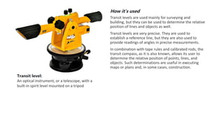
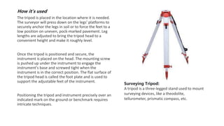
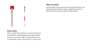
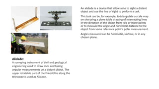
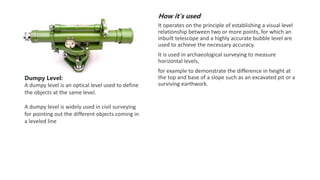
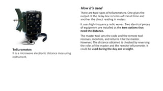
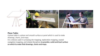
Common surveying instruments
How it’s used
 Measuring horizontal and vertical angles
 Locating points on a line
 Finding the difference in the level
 Prolonging survey lines
 Ranging curves
 Setting out grades
 Tachometric surveying
A Theodolite is used for many purposes, but mainly it is
used for measuring angles, and scaling points of
construction works.
For example, In order to determine highway points,
huge buildings’ escalating edges theodolites are used.
Depending on the job nature and the accuracy required,
theodolite produces more curved readings, using
paradoxical faces and swings or different positions for a
perfect measuring survey.
Theodolite:
A theodolite is a precision optical instrument for
measuring angles between designated visible
points in the horizontal and vertical planes.
How it’s used
Transit levels are used mainly for surveying and
building, but they can be used to determine the relative
position of lines and objects as well.
Transit levels are very precise. They are used to
establish a reference line, but they are also used to
provide readings of angles in precise measurements.
In combination with tape rules and calibrated rods, the
transit compass, as it is also known, allows its user to
determine the relative position of points, lines, and
objects. Such determinations are useful in executing
maps or plans and, in some cases, construction.
Transit level:
An optical instrument, or a telescope, with a
built-in spirit level mounted on a tripod
How it’s used
 Total stations are mainly used by land surveyors and
civil engineers, either to record features as in
topographic surveying or to set out features (such as
roads, houses or boundaries).
A total station is an electronic/optical instrument used
for surveying and building construction.
It is an electronic transit theodolite integrated with
electronic distance measurement (EDM) to measure
both vertical and horizontal angles and the slope
distance from the instrument to a particular point, and
an on-board computer to collect data and perform
triangulation calculations.
Total station:
This combines all of the functionality of a
theodolite with other abilities such as an auto-
level and electronic distance meter
How it’s used
The tripod is placed in the location where it is needed.
The surveyor will press down on the legs' platforms to
securely anchor the legs in soil or to force the feet to a
low position on uneven, pock-marked pavement. Leg
lengths are adjusted to bring the tripod head to a
convenient height and make it roughly level.
Once the tripod is positioned and secure, the
instrument is placed on the head. The mounting screw
is pushed up under the instrument to engage the
instrument's base and screwed tight when the
instrument is in the correct position. The flat surface of
the tripod head is called the foot plate and is used to
support the adjustable feet of the instrument.
Positioning the tripod and instrument precisely over an
indicated mark on the ground or benchmark requires
intricate techniques.
Surveying Tripod:
A tripod is a three-legged stand used to mount
surveying devices, like a theodolite,
tellurometer, prismatic compass, etc.
How it’s used
Survey prisms are used by surveyors and engineers to
measure the change in position of a target that is
assumed to be moving.
In surveying, a retroreflector—usually referred to as a
prism—is normally attached on a surveying pole and is
used as a target for distance measurement using, for
example, a total station.
The instrument operator or robot aims a laser beam at
the retroreflector. The instrument measures the
propagation time of the light and converts it to a
distance.
Prisms are used with survey and 3D point monitoring
systems to measure changes in elevation and position of
a point.
Surveying Prisms:
This is a corner cube or retroreflector, usually
attached to a surveying pole and utilized as a
target for distance measurement.
How it’s used
A prism pole can be used to measure the elevation of a
specific ground point by using a sight level, which is
important if you want to get accurate results.
Prism Poles:
This is a pole that someone can use to measure
the elevation of existing ground or grade when
used in conjunction with a survey level such as
an Automatic Level, Transit Level, or Laser Level.
An alidade is a device that allows one to sight a distant
object and use the line of sight to perform a task.
This task can be, for example, to triangulate a scale map
on site using a plane table drawing of intersecting lines
in the direction of the object from two or more points
or to measure the angle and horizontal distance to the
object from some reference point's polar measurement.
Angles measured can be horizontal, vertical, or in any
chosen plane.
Alidade:
A surveying instrument of civil and geological
engineering used to draw lines and taking
angular measurements on a distant object. The
upper rotatable part of the theodolite along the
telescope is used as Alidade.
How it’s used
It operates on the principle of establishing a visual level
relationship between two or more points, for which an
inbuilt telescope and a highly accurate bubble level are
used to achieve the necessary accuracy.
It is used in archaeological surveying to measure
horizontal levels,
for example to demonstrate the difference in height at
the top and base of a slope such as an excavated pit or a
surviving earthwork.
Dumpy Level:
A dumpy level is an optical level used to define
the objects at the same level.
A dumpy level is widely used in civil surveying
for pointing out the different objects coming in
a leveled line
Dioptra:
A dioptra is a classical surveying instrument used to determine the level of a
site. It is a sighting rod/tube with one end withstand. If it is used with a
protractor, it can also measure the angles.
How it’s used
There are two types of tellurometers. One gives the
output of the delay line in terms of transit time and
another the direct reading in meters.
It uses high-frequency radio waves. Two identical pieces
of equipment are installed at the two stations that
need the distance.
The master tool sets the code and the remote tool
receives, monitors, and returns it to the master.
However, The distance obtained is checked by reversing
the roles of the master and the remote tellurometer. It
could be used during the day and at night.
Tellurometer:
It is a microwave electronic distance measuring
instrument.
Plane Table:
A plane table is a plane and smooth surface or panel which is used to make
drawings, charts, and maps.
It is a device used in surveying site mapping, exploration mapping, coastal
navigation mapping, and related disciplines to provide a solid and level surface
on which to make field drawings, charts and maps.
Other tools.
Engineer’s Chain:
An engineering chain is used to measure the length of a site or place.
Measuring Tape:
A measuring tape is a graduated tap to measure the distance or the length of an object or a place. It has inch,
centimetre, feet, meters, and yard signs on it.
Ranging Rod:
Ranging rods are strait graduated or ungraduated rods used to mark the position of stations and for sighting
these stations. They are also used for ranging straight lines. They are generally made of bamboo or other types
of wood. They may also be made of metal.
Surveying Tachymeter:
Tachymeter is a modern-day device used to detect the horizontal and vertical level of objects placed on a
surface, which is being surveyed. It is an optical device.
Surveying Tape:
Surveying tape is like a simple measuring tape with graduations on it. It is an elastic device that automatically
rolls the tape.
Prismatic Compass:
A prismatic compass is a navigation and surveying instrument which is extensively used to find out the bearing
of the traversing and included angles between them, waypoints, and direction.
Graphometer:
A semicircle with 180 degrees instrument used to find the angular measurements on a plane table.
Geodimeter:
It was originally used to measure the speed of light. A geodimeter is an optical-electronic distance measuring
instrument.
Alidade
Alidade table
Cosmolabe
Dioptra
Dumpy level
Engineer's chain
Geodimeter
Graphometer
Groma (surveying)
Laser scanning
Level
Level staff
Measuring tape
Plane table
Pole (surveying)
Prism (surveying) (corner cube retroreflector)
Prismatic compass (angle measurement)
Ramsden surveying instruments
Ranging rod
Surveyor's chain
Surveyor's compass
Tachymeter (surveying)
Tape (surveying)
Tellurometer
Theodolite

Surveying instruments.pptx

  • 1.
  • 2.
    How it’s used Measuring horizontal and vertical angles  Locating points on a line  Finding the difference in the level  Prolonging survey lines  Ranging curves  Setting out grades  Tachometric surveying A Theodolite is used for many purposes, but mainly it is used for measuring angles, and scaling points of construction works. For example, In order to determine highway points, huge buildings’ escalating edges theodolites are used. Depending on the job nature and the accuracy required, theodolite produces more curved readings, using paradoxical faces and swings or different positions for a perfect measuring survey. Theodolite: A theodolite is a precision optical instrument for measuring angles between designated visible points in the horizontal and vertical planes.
  • 3.
    How it’s used Transitlevels are used mainly for surveying and building, but they can be used to determine the relative position of lines and objects as well. Transit levels are very precise. They are used to establish a reference line, but they are also used to provide readings of angles in precise measurements. In combination with tape rules and calibrated rods, the transit compass, as it is also known, allows its user to determine the relative position of points, lines, and objects. Such determinations are useful in executing maps or plans and, in some cases, construction. Transit level: An optical instrument, or a telescope, with a built-in spirit level mounted on a tripod
  • 4.
    How it’s used Total stations are mainly used by land surveyors and civil engineers, either to record features as in topographic surveying or to set out features (such as roads, houses or boundaries). A total station is an electronic/optical instrument used for surveying and building construction. It is an electronic transit theodolite integrated with electronic distance measurement (EDM) to measure both vertical and horizontal angles and the slope distance from the instrument to a particular point, and an on-board computer to collect data and perform triangulation calculations. Total station: This combines all of the functionality of a theodolite with other abilities such as an auto- level and electronic distance meter
  • 5.
    How it’s used Thetripod is placed in the location where it is needed. The surveyor will press down on the legs' platforms to securely anchor the legs in soil or to force the feet to a low position on uneven, pock-marked pavement. Leg lengths are adjusted to bring the tripod head to a convenient height and make it roughly level. Once the tripod is positioned and secure, the instrument is placed on the head. The mounting screw is pushed up under the instrument to engage the instrument's base and screwed tight when the instrument is in the correct position. The flat surface of the tripod head is called the foot plate and is used to support the adjustable feet of the instrument. Positioning the tripod and instrument precisely over an indicated mark on the ground or benchmark requires intricate techniques. Surveying Tripod: A tripod is a three-legged stand used to mount surveying devices, like a theodolite, tellurometer, prismatic compass, etc.
  • 6.
    How it’s used Surveyprisms are used by surveyors and engineers to measure the change in position of a target that is assumed to be moving. In surveying, a retroreflector—usually referred to as a prism—is normally attached on a surveying pole and is used as a target for distance measurement using, for example, a total station. The instrument operator or robot aims a laser beam at the retroreflector. The instrument measures the propagation time of the light and converts it to a distance. Prisms are used with survey and 3D point monitoring systems to measure changes in elevation and position of a point. Surveying Prisms: This is a corner cube or retroreflector, usually attached to a surveying pole and utilized as a target for distance measurement.
  • 7.
    How it’s used Aprism pole can be used to measure the elevation of a specific ground point by using a sight level, which is important if you want to get accurate results. Prism Poles: This is a pole that someone can use to measure the elevation of existing ground or grade when used in conjunction with a survey level such as an Automatic Level, Transit Level, or Laser Level.
  • 8.
    An alidade isa device that allows one to sight a distant object and use the line of sight to perform a task. This task can be, for example, to triangulate a scale map on site using a plane table drawing of intersecting lines in the direction of the object from two or more points or to measure the angle and horizontal distance to the object from some reference point's polar measurement. Angles measured can be horizontal, vertical, or in any chosen plane. Alidade: A surveying instrument of civil and geological engineering used to draw lines and taking angular measurements on a distant object. The upper rotatable part of the theodolite along the telescope is used as Alidade.
  • 9.
    How it’s used Itoperates on the principle of establishing a visual level relationship between two or more points, for which an inbuilt telescope and a highly accurate bubble level are used to achieve the necessary accuracy. It is used in archaeological surveying to measure horizontal levels, for example to demonstrate the difference in height at the top and base of a slope such as an excavated pit or a surviving earthwork. Dumpy Level: A dumpy level is an optical level used to define the objects at the same level. A dumpy level is widely used in civil surveying for pointing out the different objects coming in a leveled line
  • 10.
    Dioptra: A dioptra isa classical surveying instrument used to determine the level of a site. It is a sighting rod/tube with one end withstand. If it is used with a protractor, it can also measure the angles.
  • 11.
    How it’s used Thereare two types of tellurometers. One gives the output of the delay line in terms of transit time and another the direct reading in meters. It uses high-frequency radio waves. Two identical pieces of equipment are installed at the two stations that need the distance. The master tool sets the code and the remote tool receives, monitors, and returns it to the master. However, The distance obtained is checked by reversing the roles of the master and the remote tellurometer. It could be used during the day and at night. Tellurometer: It is a microwave electronic distance measuring instrument.
  • 12.
    Plane Table: A planetable is a plane and smooth surface or panel which is used to make drawings, charts, and maps. It is a device used in surveying site mapping, exploration mapping, coastal navigation mapping, and related disciplines to provide a solid and level surface on which to make field drawings, charts and maps.
  • 13.
    Other tools. Engineer’s Chain: Anengineering chain is used to measure the length of a site or place. Measuring Tape: A measuring tape is a graduated tap to measure the distance or the length of an object or a place. It has inch, centimetre, feet, meters, and yard signs on it. Ranging Rod: Ranging rods are strait graduated or ungraduated rods used to mark the position of stations and for sighting these stations. They are also used for ranging straight lines. They are generally made of bamboo or other types of wood. They may also be made of metal.
  • 14.
    Surveying Tachymeter: Tachymeter isa modern-day device used to detect the horizontal and vertical level of objects placed on a surface, which is being surveyed. It is an optical device. Surveying Tape: Surveying tape is like a simple measuring tape with graduations on it. It is an elastic device that automatically rolls the tape. Prismatic Compass: A prismatic compass is a navigation and surveying instrument which is extensively used to find out the bearing of the traversing and included angles between them, waypoints, and direction. Graphometer: A semicircle with 180 degrees instrument used to find the angular measurements on a plane table. Geodimeter: It was originally used to measure the speed of light. A geodimeter is an optical-electronic distance measuring instrument.
  • 15.
    Alidade Alidade table Cosmolabe Dioptra Dumpy level Engineer'schain Geodimeter Graphometer Groma (surveying) Laser scanning Level Level staff Measuring tape Plane table Pole (surveying) Prism (surveying) (corner cube retroreflector) Prismatic compass (angle measurement) Ramsden surveying instruments Ranging rod Surveyor's chain Surveyor's compass Tachymeter (surveying) Tape (surveying) Tellurometer Theodolite