This document provides an analysis of a site located in Greater Noida, Uttar Pradesh for potential development. It includes details on the site location and context, physical characteristics of the land such as topography and climate, existing infrastructure and transportation access, and surrounding land uses. The goal of the site analysis is to understand all relevant factors that could impact the design and incorporate them into a successful plan.
GROUP HOUSING : A DOMESTIC ARCHITECTURE ACCOMODATES THE GROUP RATHER THAN THE UNIT AND ITS THEREFORE PUBLIC AS WELL AS PRIVATE. IT IS FIMILIAR THROUGH THE WIDWSPREAD DEVELOPMENT OF MASS HOUSING IN THE WORLD IN WHICH INDIVIDUALS OR FAMILIES FIND LIVING SPACE EITHER IN M ULTIPLE DWELLINGS OR SINGLE LINITS PRODUCED IN QUALITY . GROUP HOUSING IS PRODUSED BY MANY KINDS OF CULTURES BY COMMUNAL STATES TO EQALIZE LIVING STANDDARDS BY TYRANTS TO ASSURE A DOCILE LABOUR FORCE, AND BY FEDUAL OR CASTE SYSTEM TO BRINGS TOGETHER MEMBERS OF A CLASS.
2. CLUSTER HOUSING
A SUBDIVISION TECHNIQUES WHERE KNOWN
AS ZERO –LOT –LINE HOUSING OR HIGH DENSITY
HOUSING DWELLING ARE GROUPED TOGHTHER
WITH COMMON AREA LEFT FOR RECREATION .
RAW HOUSING
ONE OF A SERIES OF HOUSES , OFTEN AS SIMILAR
OR IDENTICAL DESIGN, SITUATED SIDE BY SIDE
AND JOINED COMMON WALLS
3. PRADHAN MANTRI AWAS YOJANA
2 MILLION NON-SLUM URBAN POOR HOUSEHOLD
ARE PROPOSED TO BE COVERDED UNDER THE MISSION.
RAJIV AWAS YOJANA
IT UNCOURAGE “SLUM FREE INDIA” IN CITIES
IN WHICH EVERY CITIZEN HAS ACEES TO BASIC AMENITIES.
PRADHAN MANTRI GRAMIN AWAS YOZANA
PROVIDING FINANCIAL ASSISTANCE TO RURAL
POOR FOR CONSTRUCTING THEIR HOUSES THEMSELVES.
HOUSING FOR ALL BY 2022
MISSSION APPROVED A SUBSTANCIAL INCREAS IN INTEREST
RELIFE ON LOAN FOR THE URBAN POOR
TO PROMOTE AFFORDEBLE HOMES.
INTEREST SUBSIDY SCHEMES FOR HOUSING URBAN
THE SCHEMES ENVISAGES THE PROVISION OF
INTEREST TO EWS AND LIG SEGMENTS TO
ENABLES THEM TO BUY OR CONSTRUCT HOUSES.
4.Lower Income Group
Economic Weaker Section (EWS) means households with monthly household income upto Rs. 5000/- per month or as revised by the Ministry of Housing and Urban Poverty Alleviation, Government of India from time to time. Lower Income Group (LIG) means households with monthly household income between Rs. 5001/- to Rs.
5.Development of Group Housing will be under provision
of master plan, Enclave development plan and layout plan.
Minimum area of plot will be 2000sq.m
Land proposed for group housing will be located at 12m
wide exiting road, But the distance of the plot from 18m
(or above) wide road will not be more than 100m.
Slilt floor will be permitted for the purpose of parking in
group housing buildings, height of which of which be
2.1m up to the beam.
if slilt floor is used for purpose other than parking then
it will be counted in F.A.R.
Park and open area will be provided at the rate of
1.0sq.m. per person or 15% of the whole area,
whichever is more, in the plot of area 3000sq.m (or above).
This is an Architectural case study on the Centre for Environment Planning & Technology (CEPT) building. Situated in Ahmedabad, Gujarat. This is done by an architecture student in semester 5.
architectural case study
Asian games village designed by ar. raj rewal
B.Arch 4th-year sem 7
detailed zoning
analysis and survey
concept execution
referral links
https://www.scribd.com/document/415212492/Asian-Games-Village-Final
https://portfolio.cept.ac.in/fp/from-utopias-to-heterotopias-migrant-housing-values-of-time-density-culture-and-energy-ur2005-monsoon-2019/building-blocks-of-migrant-housing-monsoon-2019-ug180076
https://www.slideshare.net/WaseemNoor3/raj-rewal-asian-games-village
https://www.archdaily.com/903782/asian-games-village-residence-iii-viueller-architects
https://rajrewal.in/portfolio/asian-games-village-1980-1982/
https://qdoc.tips/asiad-villagegrp-6-pdf-free.html
https://s3.us-east-1.amazonaws.com/media.archnet.org/system/publications/contents/2850/original/DPT0402.pdf?1384768113
https://prezi.com/zj7br3xisvu8/asiad-village/
Housing case study(KAFCO housing,Aranya lowcost housing, TARA housing)Sumaiya Islam
KAFCO Housing,Bangladesh
Tara Housing,India
Aranya low cost Housing,India
Helen Housing, Switzerland
Oil and Mineral Exploration and
Development Corporation
Housing, Bangladesh
Urban Design-Literature study St. Marks Road, BangaloreAnsh Agarwal
Urban Planning
Literature study of St. Marks Road, Bangalore.
Includes:
1. Road Details
2. Survey Details & Analysis
3. Action Needed
4. Proposals
5. Action Made
6. Before & After Scenerio
7. Anatomy of Changes
Indian Institute of Management Kozhikode is an autonomous public business school located in Calicut, Kerala.
The institute, set up in 1996 by the Government of India in collaboration with the State Government of Kerala, is one of the 20 Indian Institutes of Management.
The panoramic view from the hilltop is a visual delight and conducive for learning and contemplation.
The topographical character of the site has been instrumental in determining the location of the academic and residential area.
They each occupy the summits of the two hillocks.
Spread on two hills with the buildings blending in the lush greenery with a mix of traditional Kerala style ethnic architecture with modern amenities
The design incudes the water management by using techniques like rain water harvesting ,creation of ponds for rain water and retained some of the older gullies which acted as STORM WATER DRAINAGE .
Integration of indoor and outdoor spaces in the campus
Some times there is tendency to lose a sense of unity or lose track of direction but architect has carefully and efficiently incorporated various entities in the site
The vernacular elements have been refined according to the context never failing to provide the required level of modern amenities.
Because of the terrain, there is a play of level differences
In spite of large amount of trees and vegetation their is a variety of beautiful and aesthetic plants and trees
All the buildings are oriented to a central court - typical “naalukettu” of Kerala’s traditional architecture giving a sense of unity
Auroville, City of dawn is located in state of Tamil Nadu, India, near Pondicherry in South India. .Auroville was founded as a project on experimental basis of the ‘Sri Arbindo Society’ on Wednesday 28 February 1968. The basic idea originated from Mirra Alfassa ‘The Mother ‘who was spiritually related to India.
Ma envisaged Auroville as an international township for 50,000 residents on the shape of a flower. Architect Roger Anger refined the planning and designed it in shape of Universe.He placed Matrimandir at the center of this city.
Mary Alfassa in her first message regarding the town stated that, "Auroville is meant to be a universal town where men and women of al countries are able to live in peace and progressive harmony, above all creeds, all politics and all nationalities”
.
Case study on iucaa
One of the noted works of charles correa..
this ppt shows abt the planning and design through which sir charles correa must have went throught.
This report has been prepared after getting different theoretical and practical training in Construction of Bridge and Highway of Six Lane Eastern Peripheral Expressway (NH No. NE-II) Package IV
CBSE Class X-Geo(7) : Lifelines of National Economy Chapter in an easy and simple way, for everyone to understand. For all students and who have have slow pace also.
2024.06.01 Introducing a competency framework for languag learning materials ...Sandy Millin
http://sandymillin.wordpress.com/iateflwebinar2024
Published classroom materials form the basis of syllabuses, drive teacher professional development, and have a potentially huge influence on learners, teachers and education systems. All teachers also create their own materials, whether a few sentences on a blackboard, a highly-structured fully-realised online course, or anything in between. Despite this, the knowledge and skills needed to create effective language learning materials are rarely part of teacher training, and are mostly learnt by trial and error.
Knowledge and skills frameworks, generally called competency frameworks, for ELT teachers, trainers and managers have existed for a few years now. However, until I created one for my MA dissertation, there wasn’t one drawing together what we need to know and do to be able to effectively produce language learning materials.
This webinar will introduce you to my framework, highlighting the key competencies I identified from my research. It will also show how anybody involved in language teaching (any language, not just English!), teacher training, managing schools or developing language learning materials can benefit from using the framework.
Synthetic Fiber Construction in lab .pptxPavel ( NSTU)
Synthetic fiber production is a fascinating and complex field that blends chemistry, engineering, and environmental science. By understanding these aspects, students can gain a comprehensive view of synthetic fiber production, its impact on society and the environment, and the potential for future innovations. Synthetic fibers play a crucial role in modern society, impacting various aspects of daily life, industry, and the environment. ynthetic fibers are integral to modern life, offering a range of benefits from cost-effectiveness and versatility to innovative applications and performance characteristics. While they pose environmental challenges, ongoing research and development aim to create more sustainable and eco-friendly alternatives. Understanding the importance of synthetic fibers helps in appreciating their role in the economy, industry, and daily life, while also emphasizing the need for sustainable practices and innovation.
Unit 8 - Information and Communication Technology (Paper I).pdfThiyagu K
This slides describes the basic concepts of ICT, basics of Email, Emerging Technology and Digital Initiatives in Education. This presentations aligns with the UGC Paper I syllabus.
A Strategic Approach: GenAI in EducationPeter Windle
Artificial Intelligence (AI) technologies such as Generative AI, Image Generators and Large Language Models have had a dramatic impact on teaching, learning and assessment over the past 18 months. The most immediate threat AI posed was to Academic Integrity with Higher Education Institutes (HEIs) focusing their efforts on combating the use of GenAI in assessment. Guidelines were developed for staff and students, policies put in place too. Innovative educators have forged paths in the use of Generative AI for teaching, learning and assessments leading to pockets of transformation springing up across HEIs, often with little or no top-down guidance, support or direction.
This Gasta posits a strategic approach to integrating AI into HEIs to prepare staff, students and the curriculum for an evolving world and workplace. We will highlight the advantages of working with these technologies beyond the realm of teaching, learning and assessment by considering prompt engineering skills, industry impact, curriculum changes, and the need for staff upskilling. In contrast, not engaging strategically with Generative AI poses risks, including falling behind peers, missed opportunities and failing to ensure our graduates remain employable. The rapid evolution of AI technologies necessitates a proactive and strategic approach if we are to remain relevant.
Read| The latest issue of The Challenger is here! We are thrilled to announce that our school paper has qualified for the NATIONAL SCHOOLS PRESS CONFERENCE (NSPC) 2024. Thank you for your unwavering support and trust. Dive into the stories that made us stand out!
Honest Reviews of Tim Han LMA Course Program.pptxtimhan337
Personal development courses are widely available today, with each one promising life-changing outcomes. Tim Han’s Life Mastery Achievers (LMA) Course has drawn a lot of interest. In addition to offering my frank assessment of Success Insider’s LMA Course, this piece examines the course’s effects via a variety of Tim Han LMA course reviews and Success Insider comments.
Model Attribute Check Company Auto PropertyCeline George
In Odoo, the multi-company feature allows you to manage multiple companies within a single Odoo database instance. Each company can have its own configurations while still sharing common resources such as products, customers, and suppliers.
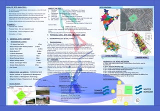
1. SITE LOCATION -
SITE
UTTAR PRADESH
GRATER NOIDA
GOAL OF SITE ANALYSIS :-
To achieve a successful design, site analysis is a must & should
be done carefully
Site Analysis involves taking an inventory of site elements and
analyzing these factors relative to the clients needs & aims
Gather relevant information about the properties of the site, from
topography to climate to wind pattern and vegetation
Analyze these features and incorporate them into the design
ELEMENT :-
General Site Context
Physical Data , Site and adjacent Land
Cultural data , Site and Adjacent Land
Correction of Data
A. GENERAL SITE CONTEXT :-
1. Geographical Location -
I. I.D Airport New Delhi 47km
II. RHazrat Nizamuddin Railway Station 31.5km
III. Anand Vihar ISBT 40.5km
IV. Noida Sector 37 25.5km
V. Lal Kuan Ghaziabad 28km
VI. Dadri Rail way station 13km
VII. Boraki Railway Station 10km
VIII. Ajibpur railway station 12.5km
IX. Omaxe Connaught Palace 07.5km
X. Greater Noida Authority 07km
XI. Pari Chowk 05km
2. Adjacent land use patterns - Institutional land
I. Skyline Institute of Engineering & Management
II. Birla Institute of Management Technology
III. Galgotias College of Engineering & Management
3. Access System -
Yamuna Expressway (105m wide) Service Road (18m wide)
12m wide
SITE
18m wide Road
Site
12m wide Road
B. PHYSICAL DATA , SITE AND ADJACENT LAND
1. GEOMORPHOLOGY & SOIL TYPES :--
I. Geomorphology -
Gautam Budh Nagar district, a part of Ganga-Yamuna Doab in the vicinity of
River Yamuna, forms almost a monotonous plain with occurrence of sand dunes,
sandy ridges, ravenous tracts and depressions close to the river system of
Yamuna. At places, close to river ravines are developed in the form of narrow
gullies on land
surface due to excessive erosion by surface runoff. Ravines form a bad land
topography along Hindon and Bhuriya Nadi between Bisrakh and Dankaur areas
and also in Jhajhar area. Lenses and beds of Kankar are seen exposed and forms
mounds or pinnacles. Flood plain of river Yamuna with remnants of old meander
scars, oxbow lakes and relict drainages is developed along the river in western
part of the district.II. Soil types -
The soil ranges from pure sand to stiff clays and including all combination of
the two extreme litho units. The pure sand is called Bhur and clay is called Matiar.
The mixture of sand and clay in equal proportion forms Dumat or loam, a good
agriculture soil. Several subcategories of Dumat are possible depending upon the
contents of clay and sand. The bad land patches (Kallor) which are ingested with
Reh
at places do not support any vegetation growth. Alluvial soils occurring in flood plain
of rivers is called Kemp which yield good crops. Kankars invariably associated with
clay and at times retards ground water movement.
HEIRARCHY OF ROAD NETWORK
o 130m. wide main arterial road ( Central Spine from North- west to
South-East)
o 105 m. wide the Meridian road.
o 80 m. wide Promenade (S.K.Road) and road along kot escape.
o 75 m. wide Noida-Greater Noida Expressway.
o 60 m. wide sector peripheral roads.
o 45 m. wide DSC Road(existing) road along railway line.
o Typical cross section for roads designed for provision for NMVs, bus
lanes, pedestrian facilities, space for all services
SITE ORIENTATION
LAND USE (Sq. Km.)
a) Forest area : 24.00
b) Net area sown : 1164.86
c) Cultivable area : 47.75
SMOOTH FLOW OF TRAFFIC -
o Roads built for almost full traffic from the start
o No direct access on arterial roads
o Design and maintenance norms specified
o Pedestrian/Cycle Movement Plan
o Liberal Parking Norms
o No parking in Road Right of Way
o Parking areas identified/developed
o Bus bays as part of road design
o Bus shelters
ABOUT THE SITE :-
I. Site Area 271mX279m =75609 sqm (18.6 acre)
II. Location Near Galgotia College Greater Noida
Expressway’ Greater Noida Utter Pradesh .
III. Longitude 28°27'18.9"N 77°29'42.8"E
IV. Land Type Flat surface land with no contours
V. Access Road Service Road 18m and collector road12m wide road
VI. Site Context The subject land has road to the south.
A minor road to the west.
The proposed site has Galgotia College to its
east and Birla
insitute of its nort.
Judge society across the expressway.
Location in the institutional area giving a calm and silent environment to
study.
The area is quite green environmental friendly and pollution free.
SUMMER
MONSOON
WINTER
MONSOON
2. 2. WATER :-
WATER LEVEL.
Water level in phreatic aquifer ranges from 3.35
to 14.40 m bgl during pre-monsoon period whereas it ranges from 2.00m to
13.95
mbgl during post monsoon period.
GROUND WATER RESOURCES:
Blockwise ground water resources as estimated using GEC, 1997
methodology jointly by CGWB (Central Ground Water Board) and State
Ground Water Department on 31.03.04 are tabulated as follows:
GROUND WATER QUALITY:
In general ground water quality in the district is good and all the constituents
are well with in the permissible limits as prescribed by ICMR (1975). The
general
range of various important chemical constituents in the ground water samples
are as
follows:
3. TOPOGRAPHY :
Flat land no contour .
Center: 28.4743879 77.5039904
Borders: 28.3796206 77.4125529 28.6170990 77.6194382
Greater Noida map, Greater Noida topography, Greater Noida elevation,
Greater Noida relief, India, Uttar Pradesh, Gautam Buddh Nagar, Greater
Noida, locality.
4. RAINFALL & CLIMATE:-
RAIN FALL.
The annual normal rainfall (1901-1970) of the district comes to 700.6 mm as
observed in the nearest rain gauge station at Sikandrabad. The maximum
rainfall occurs during the monsoon period i.e., June to September having the
normal value of 600 mm which is 85.7% of annual rainfall. August is the wettest
month having the normal rainfall of 205.8 mm followed by July when normal
rainfall received about.
CLIMATE:
The climate of the district is sub-humid and characterized by hot summer and
bracing cold season. After February there is continuous increase in
temperature till
May which is generally the hottest month. The district experiences the hottest
weather
in the month of June with average mean temperature of 32.85°C followed by
May
with 31.9°C. The coldest month is January with average mean temperature of
14.2°C
followed by December with 15.4°C.
During the southwest monsoon season the relative humidity is high and after
the withdrawal of the monsoon humidity decreases. The mean monthly
maximum
relative humidity in the morning of August month is 84% and mean monthly
minimum relative humidity measured in the morning of May is 41 %.
The normal annual mean wind speed in the district is 6.7 kmph the highest
normal wind speed is 9.2 kmph in the month of June followed by 8.3 kmph in
May.
The annual normal potential evapo-transiration of the district is 1545.3 mm.
The
maximum PET occurs in the month of June followed by May with 225.3 mm
and
222.2 mm respectively.
• Wind Direction:- South East to North West
• Humidity :- 55 to 60
SUN PATH :- From above sun path movement the following datas are
concluded as per 20 sep 2016:
Sun rise from South East 06:30
Sun set was on South West at 05:40
4. MAN-MADE STRUCTURES:-
BOUNDARY WALL.
On site there was a boundary wall around the site.
SEWERS:- There is two side sewers line on site .
POWER :-Privatised power supply is provided by Noida Power Company Ltd. By
bulk purchase from U.P. State Electricity Board and the distribution is carried out by
NPCL. The electrical network consists of 132 KV sub station, 33 KV sub station, 11
KV sub station and HTLT distribution lines. The electrical cables from 33 KV sub
station are laid underground.
RAIL :- The nearest railway station at present is Dadri and located just outside the
notified area on the main railway line to Calcutta. The rail link from Tugalabad to
Dadri and Boraki Via Noida is planned route finalized by Rail Vikas Nigam which
will link the area to the western railway main line to Bombay. Also commuter rail link
will be provided along this line. The new railway station at Boraki has also been
proposed.
SOCIAL INFRASTRUCTURE :- Social Infrastructure has been planned in an
hierarchical manner both at sector level and at city level.
TRANSIT LINE :- Regional linkages –
The main regional links available/developed so far are –
1. Noida-Greater Noida Expressway (to be further extended upto Agra)
2. Link Road from NH 24 to the ‘Entry Road’
3. Link from G.T. Road via Dadri ROB.
4. Existing Delhi-Hawraha Rail line.
ARTERIAL ROADS :-
The 5 main arterial roads i.e. the Expressway way from Noida to Greater Noida
75m wide, ‘The Entry Road’ 45.0 m wide and ‘The Promenade’ 80.0 m wide, the
105m wide road upto knowledge park-IV and 130m wide road in knowledge park-II
and III. Have been developed as high quality roads for fast movement of intra city
traffic. At present, these roads are connecting the city with the surrounding area.
The 60.0m wide sector peripheral roads are being developed in stages alongwith
the development of the sectors.
SITE BOUNDARY
WALL
BOUNDARY
WALL
SEWER LINE MANHOLESITE
SITE ELECTRICITY POLE
11KV
TRANSMISSION
TOWER
3. GAS :-Natural gas and industrial gas . Plan prepared by Greater Noida
Authority.
STEAM :- There is no steam line on site.
OTHER STRUCTURE :- In front of site metro construction n is going on.
VISUAL SPACES:-
I. YMUNA EXPRESSWAY
II. GALGOTIAS COLLEGE
III. SKYLINE COLLEGE
IV. TAJ HIGHWAY
V. METRO LINE
FOCAL POINT :- PARI CHOWK
LIGTH :- There are street light around the site.
CONVERGENCE NETWORK -
The plan for the convergence network and the laying of the optical fiber shall
be carried out by RPG Netcom Ltd. Which has been rbanizati by the State
Government for the same. This network shall also be laid underground.
TELECOMMUNICATIONS –
Three telephone exchanges are already functional in the area which are
equipped with state-of-the-art equipment and facilities. Underground telephone
lines are laid as per the demand in the various sectors. Efforts are being made
by the Authority to lay the telephone lines along with the laying of other
services at the time of development of the sectors.
SOLID WASTE MANAGEMENT -
A state of the art system for collection of solid waste from all residential,
commercial, institutional and industrial units has already been put into place
through private participation. Efforts are on for scientific disposal of the waste
through private developers. The objective is to provide a neat and clean
healthy environment to the inhabitants of the city.
EXPENDITURE AND INVESTMENT —
The Authority was set up in January 1991 and the work started with acquisition
of land. The bulk of land was transferred from U.P. State Industrial
Development Corporation which was already operational in the area.
Thereafter the land acquisition and disposal progressed in a phased manner.
INSTITUTIONAL -
The total institutional area planned as per Master Plan-2011 is 1970.03 ha.
About 1140 Ha. Area in Knowledge Park-I, II, II & IV has been planned and
developed.
There has been a significant demand of land from reputed institutions for
engineering, medical, management college and Integrated schools. Therefore
the city is becoming a knowledge hub. The institutions coming up will serve the
other areas of NCR also since accessibility and quality infrastructure is being
provided in the area. There is a significant demand from Information
Technologies (I.T.) and Information Technologies Enable Services (I.T.E.S.)
related investors, and the city is liking to become a destination for IT industry
also.
The District Headquarters have already been located in Greater Noida and
other district offices are in the process of being setup. Therefore the township
will also have an administrative character thereby adding to the tertiary sector
activity.
SITE METRO
CONSTRUCTION
PARI
CHOWK
PARI
CHOWK
YAMUNAEXPRESSWAY AND TAJ
HIGHWAY
SKY LINE COLLEGE
GALGOTIAS COLLEGE
STREET LIGHT STREET LIGHT
SOCIAL INFRASTRUCTURE :-
EDUCATION – Nursery and higher secondary schools are planned within the
sector. Higher education facilities/like technical vocational colleges, universities
are planned at the city level.
HEALTH – Dispensaries and Nursing Homes are provided at sector level. At
the city level general hospitals and rbanizatio hospitals have been planned.
One 50 beded hospital is already functional in the area.
SECURITY – Provision has been made for police posts for a group of sector
and police stations at the city level. One police station in Surajpur and one in
Sector Beta are already functional.
OTHER COMMUNITY FACILITIES :- Amongst other community
facilities are provision of Milk Booths and Vegetable ,Community Centre ,
Library , Religious Buildings which have been provided as per population
norms at sector and city level and are being developed as per the demand
build up.
HISTORY :- In the early 1980s, the government of India realised that the rapid
rate at which Delhi was expanding would result in chaos, so they planned to
develop residential and industrial areas around the capital to reduce the
demographic burden. Before Greater Noida, there were two areas that had
been developed—Gurgaon, across the border from Haryana, and Noida,
across the border with Uttar Pradesh.
Bisrakh, Uttar Pradesh; the birthplace of Demon king Ravana Noida's
infrastructure was carefully laid out, but the 1990s saw huge growth in
the Indian economy. Migration to cities like Delhi, Mumbai, Kolkata, Chennai,
and Bangalore exceeded planning estimates. Noida was developed to
accommodate population growth for 20–25 years. The massive population
influx to Delhi, however, caused it to overload in a mere 15 years,
although intake is not complete and illegal mining remains a problem. Shaheed
Bismil Park, Sector-Beta 1 in Greater Noida
The government of Uttar Pradesh decided to develop another city as an
extension to Noida with better planning. The idea was to create a world-class
city approximately 25 km from Noida. A railway station near Boraki and an
international airport were included later in the plan intending to develop Greater
Noida as an independent city; the airport was however scrapped in early 2012,
owing to environmental concernsDuring the 1990s, the Noida extension (now a
part of Gautam Buddh Nagar became what is today known as Greater Noida.
The development of the city is managed by the Greater Noida Industrial
Development Authority (GNIDA). Greater Noida is connected to Agra by the
six-lane Yamuna Expressway. The annual Indian Grand Prix is held at
the Buddh International Circuit. Roads are wide with service lanes for every
major road. The sectors are named by letters of the Greek alphabet. All cabling
and utilities have been built underground. Alpha, Beta, and Gamma are the
oldest sectors. The other emerging sectors include Xu, Delta, Mu, Omicron and
Tau. The present GNIDA office is in Gamma II sector just opposite the historical
village Rampur Jagir/Jahangir where the revolutionary Pandit Ram Prasad
Bismil lived in 1919 when he was hidden underground after
the Mainpuri conspiracy. A park has been named "Amar Shaheed Pt. Ram
Prasad Bismil Udyan" by the Uttar Pradesh Government. The 12th and
14th Auto Expos (The Motor Show) were held at India Expo Mart, Greater
Noida, in
February 2014 and 2016 respectively.
KNOWLEDGE
PARK -I
KNOWLEDGE
PARK -II
KNOWLEDGE PARK
-III
KNOWLEDGE PARK
-IV
TREE ON SITE
4. SITE
SURROUNDING
TAJ EXPRESSWAY SKYLINE COLLEGE GALGOTIAS COLLEGE
EXPO MARTHINDON RIVER
YAMUNA EXPRESSWAY SITE SUPERTECH GOLF
VILLAGE
XX’
YY’
SITE
SITE PHOTOS
Road Section