Downloaded 11 times
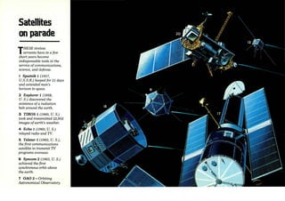


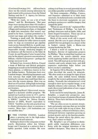
![3 16
A PORTFOLIO
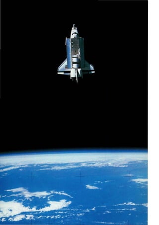
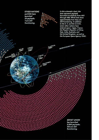
Images of earth
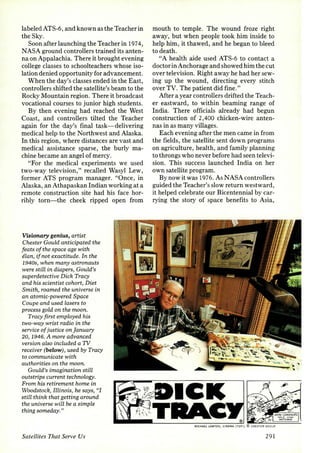
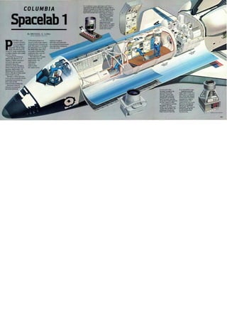
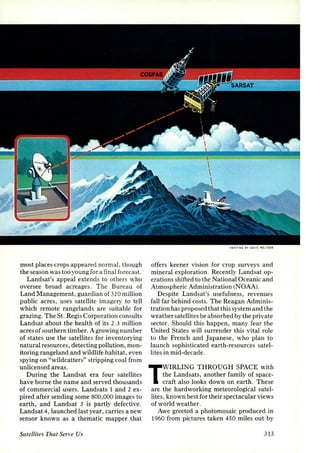
SECRETS OF THE SAHARA, hidden by
sand, are revealed by the piercing eyes of
radar. A Landsat image (below) shows a
vast sweep of sand punctuated by hills in
northwestern Sudan. The red lines
indicate the 50-kilometer-wide swath of the
imaging radar carried aboard the space
shuttle Columbia in November 1981.
Probing the sand to a depth of six
meters (20 feet), the shuttle's radar,
developed by scientists at the jet
Propulsion Laboratory (]PL), literally fills
in the space between the lines to reveal
ancient topographical features (right).
The dark region at top has been
identified as a river valley as large as that
of the present-day Nile. Below it other
riverbeds and valleys carve the bedrock. In a
similar area in Egypt, scientists dug along
a riverbed revealed by radar and discovered
arrowheads 100,000 to 200,000 years old.
BOTH NASA JET PROPULSION LABORATORY](https://image.slidesharecdn.com/satellitesthatserveusthomas-141006221619-conversion-gate01/85/Satellites-that-serve-us-thomas-43-320.jpg)
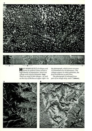
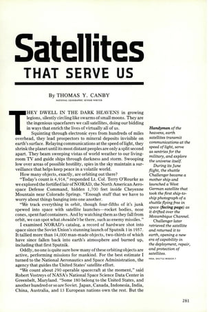
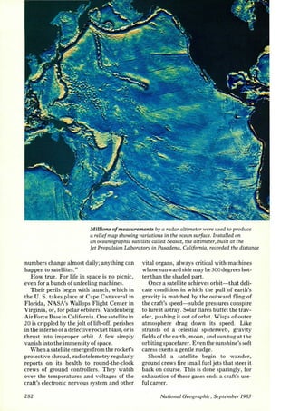
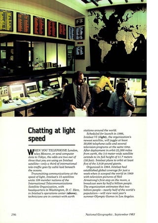
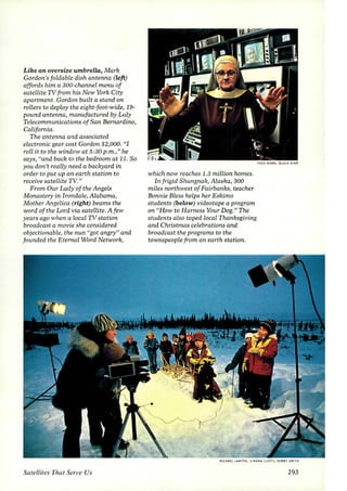
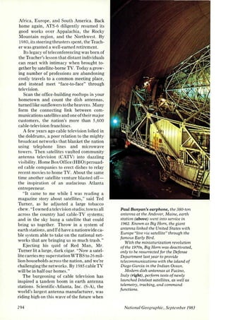
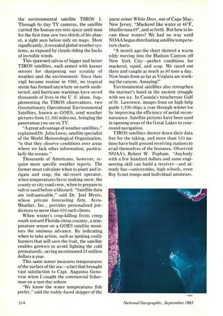
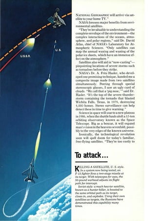
![made by the shuttle's radar in a sweep
from the Great Wall to the Yellow Sea.
An enlargement (below, middle) of
area B shows drainage patterns
radiating from the Luya Mountains
in Shanxi Province. The mountain
peaks are heavily forested and show as
bright areas.
The mountains meet the Mu Us
Desert (bottom left) in an enlargement
of area A.
Principal investigator of the team
that created the shuttle's radar, Dr.
Charles Elachi (right) examines strips
of the imagery at]PL. "We knew in
theory that radar could penetrate
sand," he says, "but this i.s the first time
it has been verified on a large scale."
From archaeology to geologic
mapping, Dr. Elachi sees a bright future
for the new imaging process. On a
shuttle mission next year, the radar· will
image Egypt's entire Western Desert.
NASA plans to put the radar on a
spacecraft bound for Venus in 1988 to
create the first map of that cloudcovered
planet.
From the Great Wall to
the Yellow Sea, the 50-
kilometer-wide track
of the shuttle's imaging
radar traverses deserts,
mountains, and
agricultural areas.
32 1](https://image.slidesharecdn.com/satellitesthatserveusthomas-141006221619-conversion-gate01/85/Satellites-that-serve-us-thomas-48-320.jpg)


![made by the shuttle's radar in a sweep
from the Great Wall to the Yellow Sea.
An enlargement (below, middle) of
area B shows drainage patterns
radiating from the Luya Mountains
in Shanxi Province. The mountain
peaks are heavily forested and show as
bright areas.
The mountains meet the Mu Us
Desert (bottom left) in an enlargement
of area A.
Principal investigator of the team
that created the shuttle's radar, Dr.
Charles Elachi (right) examines strips
of the imagery at]PL. "We knew in
theory that radar could penetrate
sand," he says, "but this i.s the first time
it has been verified on a large scale."
From archaeology to geologic
mapping, Dr. Elachi sees a bright future
for the new imaging process. On a
shuttle mission next year, the radar· will
image Egypt's entire Western Desert.
NASA plans to put the radar on a
spacecraft bound for Venus in 1988 to
create the first map of that cloudcovered
planet.
From the Great Wall to
the Yellow Sea, the 50-
kilometer-wide track
of the shuttle's imaging
radar traverses deserts,
mountains, and
agricultural areas.
32 1](https://image.slidesharecdn.com/satellitesthatserveusthomas-141006221619-conversion-gate01/85/Satellites-that-serve-us-thomas-52-320.jpg)
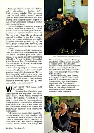
![(Continued/rom page 315) the famed Van
Allen belts. Since then , at least a quarter of
all satellites have been dedicated to science
programs, coordinated largely by NASA,
the Soviet Union, and the European Space
Agency.
Training their sensors on earth's surface,
they have mapped its varying magnetic contours,
measured the drift of the continents,
and showed that the "level" sea actually
undulates with great troughs and ridges
varying 600 feet in elevation. Studying the
atmosphere, they record fluctuations of its
ozone content. Carrying astronomers' eyes
beyond earth's obscuring atmosphere, they
have opened dramatic windows onto the
universe, including the discovery of X-ray
sources that may indicate the locations of
black holes.
SCANNING their green-tinted scopes in
March of 1981, radar operators at
NORAD detected the ascent of Soviet
Cosmos satellite number 1258. Interest
quickened as the spacecraft gained on another
Soviet satellite, Cosmos 124 1.
Two orbits after launch, radar showed
Cosmos 1258 closing on its quarry. The rest
is classified, but in a likely scenario, the pursuer
suddenly vanished-exploded by a signal
sent up by Russians on the ground. Its
shrapnel smashed into Cosmos 124 1. It was
the 19th known test of a Soviet hunter-killer
satellite, and the ninth simulated kill.
Lt. Gen. Kelly Burke, then chief of research
for the U. S. Air Force, told me of
U. S. efforts to develop a counterforce.
"Soon we'll be demonstrating an antisatellite
missile fired from a fighter plane, and it
will be better than the Soviet system," said
General Burke. "In most areas of space," he
added, "we have a clear technological lead."
Will satellites someday become chariots
of war, hurling the thunderbolts of lasers
and particle beams at cringing earthlings?
International treaties, always fragile,
prohibit deployment of weapons of mass
destruction in space. But some authorities
believe the Soviet Union is developing a
satellite-borne laser system that by middecade
could be capable of destroying U. S.
satellites or missiles. The Department of Defense
contends that the Soviet laser program
is three to five times as large as that of the
326
U. S. Other experts, however, believe that a
parallel U. S. program would be disastrously
expensive, if not also unfeasible.
"Satellites are ill suited for the role of destruction,"
said Dr. Harris Mayer, a space
and defense scientist. "Equipping them for
the massive terrestrial bombardments of
Star Wars would require orbiting prohibitive
amounts of energy and mass. Communications
surveillance and navigationthese
will be the military tasks of satellites."
In Dr. Mayer's view of space and war:
• Swarms of simple, low-flying communication
satellites-too many to knock outmaintain
vital command links.
• Powerful navigation satellites, beaming
down directional signals through any
weather, guide tanks, ships, aircraft, missiles-
even foot soldiers wearing tiny wrist
receivers.
• Denying the enemy the cover of darkness,
space lasers bathe the night battlefield with
light invisible to the enemy's unaided eye,
but bright as moonlight to friendly forces
equipped with special eyeglasses.
• Nuclear-powered satellites emit electric
impulses that jam electronic systems, such
as those that controlled Argentine air-tosurface
missiles that sank a British destroyer
during the Falkland Islands conflict.
The satellites, meanwhile, will not be sitting
ducks. "Those in geostationary orbit,
which include most military spacecraft, are
relatively invulnerable," said Lt. Gen.
Richard C. Henry (Ret.), former commander
of the Air Force Space Division.
"If an A-sat [antisatellite] approaches, we
can command a satellite to evade by moving
it miles away, then move it back. Satellite
circuitry is hardened against the radiation of
nuclear explosion, known as an electromagnetic
pulse. We provide elaborate defenses
against frequency jamming and against
tricking a satellite with false commands.
And for many military satellites in orbit
there's a spare parked nearby, ready to be
brought on-line when needed.
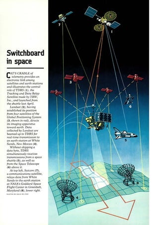
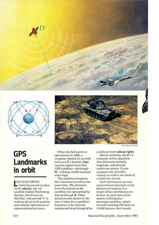
"A revolution in missile delivery will
come with the new Global Positioning System,
" continued General Henry. "Guided
by these navigational satellites, missiles
traveling thousands of miles will be able
to pinpoint their targets within hundreds
of feet."
National Geographic, September 1983](https://image.slidesharecdn.com/satellitesthatserveusthomas-141006221619-conversion-gate01/85/Satellites-that-serve-us-thomas-57-320.jpg)


The document discusses the evolution and significance of satellites in modern life, highlighting their roles in communication, surveillance, and scientific exploration. It notes the presence of approximately 4,914 objects in orbit, with about 290 being active satellites that assist in various missions for humanity. The text also details the challenges satellites face, including hazards during launch and the complexities of maintaining their orbits, as well as historical milestones in satellite technology.


