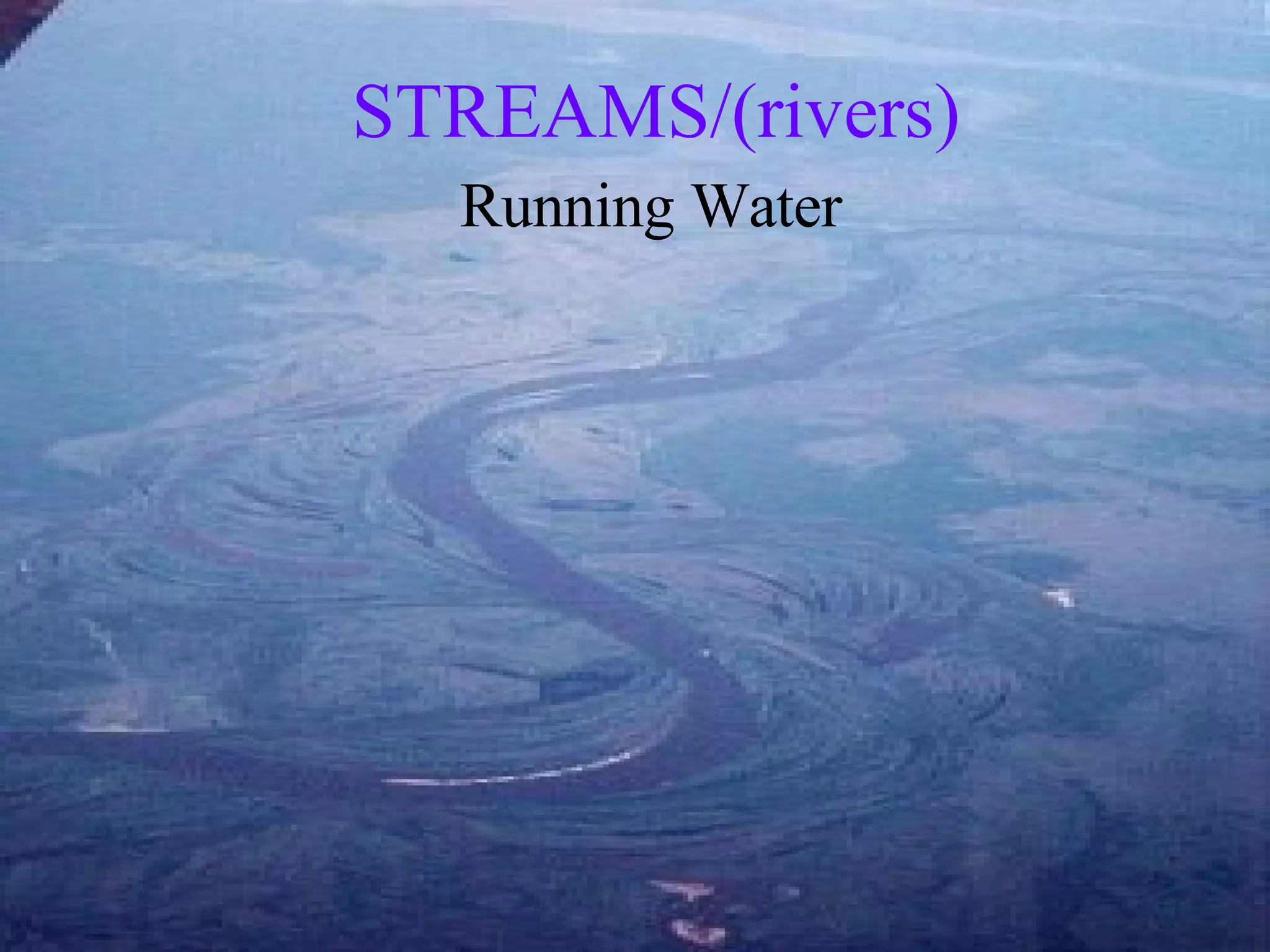
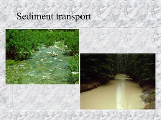
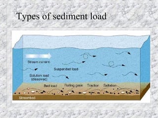
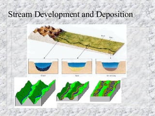
STREAMS/(rivers) Running Water
Soil/Bedrock attack When a gully is cut into the ground below the water table it becomes a permanent stream (once formed, it lengthens by eroding backwards) when tributary gullies cut below water table a river system is born Stream erosion- dominant agent erosion   Mechanical weathering-  abrasion:  breakdown of bedrock by grinding action of sand, pebbles and boulders moved by stream tools are also worn down and rounded
Running water and chemical weathering Rapidly running water has lifting effect that splits off and moves rock fragments Dissolving soluble rocks, minerals and cement- forms pits and holes in riverbed widens existing cracks and holes
Sediment transport
Removal of weathered rock Load - the amount of sediment carried by a river- depends on velocity and volume   solution (25%) : dissolved material transported in rivers- mostly form groundwater seepage (mostly Ca and Mg) suspension (50%) : sediment transported in the water column- turbulence keeps it afloat though it is denser than water (clay, silt, rarely fine sand)- give muddy look bed load (25%) : sediment moved along the bottom of a river (saltation, rolling, and traction) sand, pebbles and boulders  undisturbed areas (25% suspension, 75% solution)
Types of sediment load
Carrying Power and Load Carrying power - indicated by total amount of sediment transported and by the size of the particles- depends on nature of stream, climate, kind of bedrock and season ALSO ON Discharge and speed  (velocity)   the volume of water flowing past a given point in the stream at a given time (m³/s) speed depends mostly on gradient (   elevation/distance) flood stage flow is fastest and most erosive- scours bed  Water flow is quickest in top center of streams (no friction from the river banks or bottom
Sediment Deposition   click4videoclip Denser/large/rounded/heavier particles often with a smaller surface area to volume ratio fall out first and more rapidly as streams flow from their origin (source) Occurs due to drop in speed (energy) (less energy = less ability to transport denser/larger particles)  From slope decrease, bed widening, obstructions Most dramatically when emptying into a lake or an ocean, or into a flat valley at the base of a mountain Occurs due to a decrease in discharge Discharge decreases during passage through arid region (evaporation and seepage) or when diverted for irrigation or city water supplies
River Valleys V-shaped : mountain streams and high plateaus in areas with enough rainfall to wash sides of valley into stream  might form canyons in dry areas- little or no erosion of valley walls canyon formation: depends on bedrock, sediment load, discharge, and climate (image-  str  v  sha )
Stream valley V-shape
Valley Downcutting A stream cannot cut any lower than its  base level-   (image on next slide) the level of the stream or body of water into which it flows: (it may build up or erode down with fall or rise in water level of lower water body) near base level the stream slope and speed decrease Down-cutting lessens
Base Level
Widening the Valley Occurs throughout river history particularly after down-cutting slows weathering and erosion of valley walls by stream and its tributaries creates wider valley with broad floor and gently sloping walls
Lengthening the Valley Headward erosion - wearing away of the land at the headwater of a gully or stream valley begins to occur when a hillside is stripped of its protective vegetation cover Also occurs with waterfalls as they eat backwards at point of the falls
River Stages : Stage Not Age YOUTHFUL STAGE All of the features in each of the three stream stages can be found in the  drainage basin:  the area drained by a  river and all of its tributaries Characterized by:   broad uplands with v-shaped valleys steep gradient (high energy) coarse bed load rapid down-cutting narrow, straight channels  lack of flood plain water falls and rapids in areas of differential uplift  obstruction by large boulders (early weathering/erosion stages) few tributaries
MATURE STAGE Characterized by:   less gradient (less energy) moderate current but less down-cutting medium to small sized particle load more lateral erosion (cut banks and point bars) meanders start forming water flows around curves at different rates faster (outer banks) = erosion slower (inner banks ) = deposition broader valleys  a lot of tributaries and distributaries
OLD STAGE Characterized by: gentle gradient (near base level) nearly flat slope = lower energy deposits sediments in its channel and on its banks fine-grained sediment load wide, meandering stream valleys  large flood plain  mostly lowland (swamps and oxbow lakes) very few tributaries
Stream Development and Deposition
Rejuvenated Rivers Rivers are rejuvenated when an existing river’s gradient is increased due to movement in Earth’s crust Increased slope allows river to cut deeper into valley floor (stream and valley are already developed past the  youthful stage) Step-like terraces might be formed on each side of stream Provides evidence of uplift and downcutting in new valley floor
Drainage Patterns and Stream Paths Braided  image next slide Dendritic  image next slide Meandering  Stream avulsion - abandon existing course and/or delta to form a new one  Stream piracy  (stream capture)- lengthening of a river by  headward erosion   headward erosion of one river wears through a divide and captures the headwater of another river (nick point- where capture occurs) Stream order - 1 st  order: no inflowing streams up to a given point; 2 nd  order: one inflowing stream past a given point; 3 rd  order: 2 inflowing streams past a given point; 4 th  order: etc.
Braided and Dendritic Stream Images
Stream Piracy  (arrow = headward erosion of divide)
Stream Order
Divides and Drainage Basins Stream divides - high parts of land that separate rivers and river systems- separate rivers that flow east vs. west, north vs. south etc. Great Continental Divide, Appalachian Mts., and a low divide in MN and WI separates Mississippi River system from land sloping toward Great Lakes and Arctic Ocean Watershed  ( drainage basin ) -  the area drained by a river directly and all its tributaries (trunk stream and tributaries) largest in the U.S. is Mississippi River system
Drainage Divides and Drainage Basin Images
Water and Wind Gap Formation River cuts into valley and meets a very resistant rock formation that wears away more slowly than surrounding rock When down-cutting is at same rate as land is being slowly uplifted a narrow, deep notch is cut in the ridge through which the river runs-  a water gap an abandoned water gap-  wind gap-  from stream capture
Potholes and Plunge Pools Potholes:  form when streams run over an irregular bed and develop whirlpools that swirl sand, pebbles and small boulders and grind deep circular holes  Plunge Pools:  very large potholes at base of waterfalls
Waterfalls  Steep slopes and cliffs of rapids and waterfalls form when: River flows over hard igneous rocks onto sedimentary rocks in areas of uplift Differential glacial erosion between valleys Temporary features: Waterfalls are areas where stream erosion is greatest Undermining:  water falling into plunge pool at base of falls erodes rock there leaving overhanging cliff  Breakage at cliff causes recession of falls Especially when rock is fractured or poorly cemented
Meanders  Meanders  form as riverbed gradually shifts toward the outside bend in the river Water is fastest and most erosive on outer banks Form cut banks Entrenched meanders- form  in deep canyons after plateaus are uplifted
Sediment Deposits in Stream Deposits on inner banks Point bars (on inside of cut banks)  Deposits in stream channel Sand (gravel) bars (in braided streams and shallow spots in streams)
Oxbow Lakes Oxbows  form when river curves become too large and the river breaks through a bend- called a  cutoff Sediment deposition at ends of abandoned meander- when it fills in an  oxbow lake  forms
Floodplain Flood deposition on valley floor is instant because friction of land causes river to lose ability to transport particles Flood deposits are thicker and coarser near river banks and thinner and finer in floodplain
Floodplain Features Levees-  thick deposits built up along stream banks Back swamp-  murky water in lowest areas away from levees- fine-grained sediment Floodplain deposits are very fertile
Deltas and Alluvial Fans Fan-shaped deposits at mouth of river deposition in quiet water bodies) (flat profile)  Deposition due to drop in energy (clay and silt) Distributaries may form as delta grows Image next slide Sloping fan-shaped deposits (on land)  Sediments are washed down from slopes above to a flat area in a dry region Coarse sand and gravels Image next slide
Delta and Alluvial Fans
Flood Types Ordinary flood :   from heavy or long-lasting rains or winter snow melts over much of drainage basin Flash flood:   cloudbursts -  especially if over a  narrow valley Runoff Flood recurrence interval How long between flood small vs catastrophic Dam breaks including ice jams or volcanic ash, cinder and lava dams
Flood Prevention Stop removing natural vegetation such as trees, shrubs, and grass- especially in headwaters Store runoff in reservoirs/build dams Dig drainage channels/spillways (near mouth) Build up levees

Running Water Streams Online

  • 1.
  • 2.
    Soil/Bedrock attack Whena gully is cut into the ground below the water table it becomes a permanent stream (once formed, it lengthens by eroding backwards) when tributary gullies cut below water table a river system is born Stream erosion- dominant agent erosion Mechanical weathering- abrasion: breakdown of bedrock by grinding action of sand, pebbles and boulders moved by stream tools are also worn down and rounded
  • 3.
    Running water andchemical weathering Rapidly running water has lifting effect that splits off and moves rock fragments Dissolving soluble rocks, minerals and cement- forms pits and holes in riverbed widens existing cracks and holes
  • 4.
  • 5.
    Removal of weatheredrock Load - the amount of sediment carried by a river- depends on velocity and volume solution (25%) : dissolved material transported in rivers- mostly form groundwater seepage (mostly Ca and Mg) suspension (50%) : sediment transported in the water column- turbulence keeps it afloat though it is denser than water (clay, silt, rarely fine sand)- give muddy look bed load (25%) : sediment moved along the bottom of a river (saltation, rolling, and traction) sand, pebbles and boulders undisturbed areas (25% suspension, 75% solution)
  • 6.
  • 7.
    Carrying Power andLoad Carrying power - indicated by total amount of sediment transported and by the size of the particles- depends on nature of stream, climate, kind of bedrock and season ALSO ON Discharge and speed (velocity) the volume of water flowing past a given point in the stream at a given time (m³/s) speed depends mostly on gradient (  elevation/distance) flood stage flow is fastest and most erosive- scours bed Water flow is quickest in top center of streams (no friction from the river banks or bottom
  • 8.
    Sediment Deposition click4videoclip Denser/large/rounded/heavier particles often with a smaller surface area to volume ratio fall out first and more rapidly as streams flow from their origin (source) Occurs due to drop in speed (energy) (less energy = less ability to transport denser/larger particles) From slope decrease, bed widening, obstructions Most dramatically when emptying into a lake or an ocean, or into a flat valley at the base of a mountain Occurs due to a decrease in discharge Discharge decreases during passage through arid region (evaporation and seepage) or when diverted for irrigation or city water supplies
  • 9.
    River Valleys V-shaped: mountain streams and high plateaus in areas with enough rainfall to wash sides of valley into stream might form canyons in dry areas- little or no erosion of valley walls canyon formation: depends on bedrock, sediment load, discharge, and climate (image- str v sha )
  • 10.
  • 11.
    Valley Downcutting Astream cannot cut any lower than its base level- (image on next slide) the level of the stream or body of water into which it flows: (it may build up or erode down with fall or rise in water level of lower water body) near base level the stream slope and speed decrease Down-cutting lessens
  • 12.
  • 13.
    Widening the ValleyOccurs throughout river history particularly after down-cutting slows weathering and erosion of valley walls by stream and its tributaries creates wider valley with broad floor and gently sloping walls
  • 14.
    Lengthening the ValleyHeadward erosion - wearing away of the land at the headwater of a gully or stream valley begins to occur when a hillside is stripped of its protective vegetation cover Also occurs with waterfalls as they eat backwards at point of the falls
  • 15.
    River Stages :Stage Not Age YOUTHFUL STAGE All of the features in each of the three stream stages can be found in the drainage basin: the area drained by a river and all of its tributaries Characterized by: broad uplands with v-shaped valleys steep gradient (high energy) coarse bed load rapid down-cutting narrow, straight channels lack of flood plain water falls and rapids in areas of differential uplift obstruction by large boulders (early weathering/erosion stages) few tributaries
  • 16.
    MATURE STAGE Characterizedby: less gradient (less energy) moderate current but less down-cutting medium to small sized particle load more lateral erosion (cut banks and point bars) meanders start forming water flows around curves at different rates faster (outer banks) = erosion slower (inner banks ) = deposition broader valleys a lot of tributaries and distributaries
  • 17.
    OLD STAGE Characterizedby: gentle gradient (near base level) nearly flat slope = lower energy deposits sediments in its channel and on its banks fine-grained sediment load wide, meandering stream valleys large flood plain mostly lowland (swamps and oxbow lakes) very few tributaries
  • 18.
  • 19.
    Rejuvenated Rivers Riversare rejuvenated when an existing river’s gradient is increased due to movement in Earth’s crust Increased slope allows river to cut deeper into valley floor (stream and valley are already developed past the youthful stage) Step-like terraces might be formed on each side of stream Provides evidence of uplift and downcutting in new valley floor
  • 20.
    Drainage Patterns andStream Paths Braided image next slide Dendritic image next slide Meandering Stream avulsion - abandon existing course and/or delta to form a new one Stream piracy (stream capture)- lengthening of a river by headward erosion headward erosion of one river wears through a divide and captures the headwater of another river (nick point- where capture occurs) Stream order - 1 st order: no inflowing streams up to a given point; 2 nd order: one inflowing stream past a given point; 3 rd order: 2 inflowing streams past a given point; 4 th order: etc.
  • 21.
    Braided and DendriticStream Images
  • 22.
    Stream Piracy (arrow = headward erosion of divide)
  • 23.
  • 24.
    Divides and DrainageBasins Stream divides - high parts of land that separate rivers and river systems- separate rivers that flow east vs. west, north vs. south etc. Great Continental Divide, Appalachian Mts., and a low divide in MN and WI separates Mississippi River system from land sloping toward Great Lakes and Arctic Ocean Watershed ( drainage basin ) - the area drained by a river directly and all its tributaries (trunk stream and tributaries) largest in the U.S. is Mississippi River system
  • 25.
    Drainage Divides andDrainage Basin Images
  • 26.
    Water and WindGap Formation River cuts into valley and meets a very resistant rock formation that wears away more slowly than surrounding rock When down-cutting is at same rate as land is being slowly uplifted a narrow, deep notch is cut in the ridge through which the river runs- a water gap an abandoned water gap- wind gap- from stream capture
  • 27.
    Potholes and PlungePools Potholes: form when streams run over an irregular bed and develop whirlpools that swirl sand, pebbles and small boulders and grind deep circular holes Plunge Pools: very large potholes at base of waterfalls
  • 28.
    Waterfalls Steepslopes and cliffs of rapids and waterfalls form when: River flows over hard igneous rocks onto sedimentary rocks in areas of uplift Differential glacial erosion between valleys Temporary features: Waterfalls are areas where stream erosion is greatest Undermining: water falling into plunge pool at base of falls erodes rock there leaving overhanging cliff Breakage at cliff causes recession of falls Especially when rock is fractured or poorly cemented
  • 29.
    Meanders Meanders form as riverbed gradually shifts toward the outside bend in the river Water is fastest and most erosive on outer banks Form cut banks Entrenched meanders- form in deep canyons after plateaus are uplifted
  • 30.
    Sediment Deposits inStream Deposits on inner banks Point bars (on inside of cut banks) Deposits in stream channel Sand (gravel) bars (in braided streams and shallow spots in streams)
  • 31.
    Oxbow Lakes Oxbows form when river curves become too large and the river breaks through a bend- called a cutoff Sediment deposition at ends of abandoned meander- when it fills in an oxbow lake forms
  • 32.
    Floodplain Flood depositionon valley floor is instant because friction of land causes river to lose ability to transport particles Flood deposits are thicker and coarser near river banks and thinner and finer in floodplain
  • 33.
    Floodplain Features Levees- thick deposits built up along stream banks Back swamp- murky water in lowest areas away from levees- fine-grained sediment Floodplain deposits are very fertile
  • 34.
    Deltas and AlluvialFans Fan-shaped deposits at mouth of river deposition in quiet water bodies) (flat profile) Deposition due to drop in energy (clay and silt) Distributaries may form as delta grows Image next slide Sloping fan-shaped deposits (on land) Sediments are washed down from slopes above to a flat area in a dry region Coarse sand and gravels Image next slide
  • 35.
  • 36.
    Flood Types Ordinaryflood : from heavy or long-lasting rains or winter snow melts over much of drainage basin Flash flood: cloudbursts - especially if over a narrow valley Runoff Flood recurrence interval How long between flood small vs catastrophic Dam breaks including ice jams or volcanic ash, cinder and lava dams
  • 37.
    Flood Prevention Stopremoving natural vegetation such as trees, shrubs, and grass- especially in headwaters Store runoff in reservoirs/build dams Dig drainage channels/spillways (near mouth) Build up levees