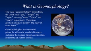
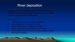
What is Geomorphology?
The word “geomorphology" comes from
the Greek roots "geo,“ “morph,” and
“logos,” meaning “earth,” “form,” and
“study,” respectively. Therefore,
geomorphology is literally “the study of
earth forms.”
Geomorphologists are concerned
primarily with earth’s surficial features,
including their origin, history, composition,
and impact on human activity.
Photo by NASA
Rivers
• Source – The place where a river begins.
• Course – The route the river takes to the
sea
• Tributary – A small river that joins a larger
river.
• Confluence – The point where the
tributary joins the river.
Common River Terms
• Mouth – The point where the river enters
the sea.
• Estuary – The part of the mouth that is
tidal.
• Basin – The area of land drained by a
river.
• Watershed – The high ground separating
one river basin from another.
RIVER PROCESSES:
Three river processes:
1. Transportation
2. Deposition
3. Erosion
RIVER TRANSPORTATION
The load is transported by 4 ways:
 Solution – material is dissolved in the water and is carried
along by it. Salt carried in solution is the reason why seawater
is salty. NOT VISIBLE
 Suspension – fine material is carried along by the river. If the
river slows down this material can be dropped on the bed of
the river – this is how rivers & canals “silt up”. VISIBLE
 Saltation – stones bouncing along the river bed – easily seen
(bed load)
 Traction – Heaviest stones dragged along river bed (bed load)
Controlling factors of river transportation:
1.Density of the sediments
2.Size of the sediment
3.Velocity of water
River deposition
Deposition: when velocity begins to fall, it has less energy and no
longer had competence and capacity to carry all its load so largest
particles, materials begins to be deposited.
When occur?
1. Low discharge during period of low precipitation
2. Less velocity when river enter sea or lake.
3. Shallow water occurs on inside of a meander.
4. The load suddenly increase (debris from landslide)
5. River overflow its bank so velocity outside channel is reduced.
(resulting in floodplain)
 Hydraulic Action
 The force of moving water, aided by the process of cavitation
(popping of air bubbles in the river, creating tiny explosions)
 Abrasion (a.k.a. Corrasion)
 The river’s load (stones and sand/grit carried by the water) wears
away the bed and sides – river “sandpaper”
 Attrition
 Rocks hitting each other and being worn away
 Solution
 Chemicals in the river water wearing away the bed and banks
River erosion.
Erosion: wearing away of river bed and bank.
There are four main process of erosion:
Bank Caving
 Formed by hydraulic action eroding the river banks
 Leads to a small temporary “cave” in the bank – this usually
collapses after a short period
Abrasion/Corrasion
 Stones acting as “Sandpaper” – wearing down the river bed
(bottom) and banks (sides)
Attrition
 Stones hitting off each other and getting smaller
 Is the main reason why stones from the sea are rounded
Solution
 Chemical weathering by river water
 Controlling factors of river erosion:
1.Nature of the rocks
2.Nature of water
3.Velocity of water
4.Presence of joints
5.Land form
6.Attitude of the rocks
Stages of a river
Youthful Stage
The youthful river has a small amount of water
but it travels very quickly down the steep
mountain slope.
Most of its energy is used to erode (wear away)
the landscape.
This erosion (wearing away) occurs in 4 ways.
Landforms of the Youthful Stage
• All of the erosion by the river creates features or
landforms on the landscape.
Three features created in the youthful stage are,
1. V-shaped Valleys
2. Interlocking Spurs
3. Waterfalls
V-Shaped Valleys
• V-shaped valleys get their name from their shape. The river
erodes the landscape and creates a valley in the shape of a V.
• This occurs because of Vertical Erosion. The river cuts down into
the river bed, making it deeper. It creates a narrow deep valley.
Mechanical weathering and mass movement create the V shape.
See Diagram.
V-Shaped Valleys
Interlocking Spurs
• As the rivers flows it meets areas of hard rock. It cannot
erode these so it flows around them.
• This creates a zigzag course. See Diagram.
Waterfalls
• Waterfalls are formed when rivers flow
over areas of hard and soft rock.
• The river erodes the soft rock but cannot
erode the hard rock. This creates a step
which the water starts to fall over.
• The falling water erodes deeper into the
bed. The rivers load creates a Plunge Pool
as it falls. See Diagram.
Waterfalls
The Mature Stage
• We now know that during the youthful
stage the river is mainly eroding the
landscape.
• Erosion breaks off particles of rock and
soil from the bed and banks of the
river. They are carried along by the
river and are known as the Load.
• The load is carried from upland to
lowland areas. This process is called
River Transportation.
Landforms of the Mature Stage
In the Mature Stage the river begins to slow down,
and so it begins to deposit some of its load. It
creates the following features.
1. Wide river valley
2. Meanders
3. Flood plain
Landforms of the Mature Stage
Wider River Valley
In the mature stage the river moves from
side to side and the valley becomes wide
and flat. Weathering and Mass Movement
continue to wear away at the sides of the
valley. See diagram.
Landforms of the Mature Stage
Meanders
Meanders are bends or curves along the river. They are formed by erosion and
deposition. Erosion occurs on one side of the river while deposition occurs on
the opposite side. This continues, making the bends sharper. See diagrams.
Meanders
Meander parameters:
 Meander Length :It is the axial length of one meander i.c the tangential distance between the
corresponding points of a meander.
 Meander Belt: It is the distance between the outer edges of clockwise and anti-clockwise loops of the
meander.
 Meander ratio: It is the ratio of meander belt to meander length.
 Crossings or cross-overs: The short straights reaches of the river connecting two consecutive
clockwise and anti-clockwise loops, are called crossings or cross-overs.
 𝑆𝑖𝑛𝑢𝑜𝑠𝑖𝑡𝑦 𝐼𝑛𝑑𝑒𝑥 =
𝐶ℎ𝑎𝑛𝑛𝑒𝑙 𝑙𝑒𝑛𝑔𝑡ℎ
𝐷𝑖𝑠𝑝𝑙𝑎𝑐𝑒𝑚𝑒𝑛𝑡
 Sinuosity is the ratio between
channel length and
displacement (straight line
distance) between two points
in the river’s course.
Landforms of the Mature Stage
Flood Plain
A flood plain is the flat area of land on either side
of the river. After heavy rain the river sometimes
floods. The water spreads out over the land on
either side of the river. When the river retreats it
leaves behind a thin layer of alluvium. After many
floods a thick layer of alluvium is created. This is
very fertile soil.
The Old Stage
• In the Old Stage the river is
carrying lots of sand and
silt. It is now flowing over
flat land and so it is moving
slowly. Therefore it begins
to drop off its load. This is
called deposition. Like
erosion in the Youthful
Stage, deposition also
creates many features or
landforms.
Landforms of the Old Stage
The following features or landforms are
created by river deposition in the Old Stage.
1. Ox-Bow Lakes
2. Levees
3. Delta
Landforms of the Old Stage
Ox-Bow Lakes
An ox-bow lake is a horseshoe
shaped lake found beside a
river. Ox-bow lakes are formed
when continued erosion and
deposition create very
pronounced meanders.
Eventually the river cuts through
the neck of the meander.
Deposition then occurs which
leaves the ox-bow lake
separated from the river.
How an Ox-Bow Lake is Made
Landforms of the Old Stage
Levees
Levees are raised banks of deposited material
found along the banks of the river. When the river
floods and spreads out over the floodplain, the
heaviest material is deposited close to the river.
Over time and after many periods of flooding this
deposited material forms levees along the banks of
the river.
Levees – Raised Banks
Landforms of the Old Stage
Delta
A Delta is a triangular shaped piece of land
which is formed at the mouth of the river. As
the river enters the sea it drops off all the
remaining material it is carrying. This
material builds up to form new land. The river is
forced to break up into smaller channels called
distributaries.
River

River

  • 1.
    What is Geomorphology? Theword “geomorphology" comes from the Greek roots "geo,“ “morph,” and “logos,” meaning “earth,” “form,” and “study,” respectively. Therefore, geomorphology is literally “the study of earth forms.” Geomorphologists are concerned primarily with earth’s surficial features, including their origin, history, composition, and impact on human activity. Photo by NASA
  • 2.
  • 4.
    • Source –The place where a river begins. • Course – The route the river takes to the sea • Tributary – A small river that joins a larger river. • Confluence – The point where the tributary joins the river. Common River Terms
  • 5.
    • Mouth –The point where the river enters the sea. • Estuary – The part of the mouth that is tidal. • Basin – The area of land drained by a river. • Watershed – The high ground separating one river basin from another.
  • 6.
    RIVER PROCESSES: Three riverprocesses: 1. Transportation 2. Deposition 3. Erosion
  • 7.
    RIVER TRANSPORTATION The loadis transported by 4 ways:  Solution – material is dissolved in the water and is carried along by it. Salt carried in solution is the reason why seawater is salty. NOT VISIBLE  Suspension – fine material is carried along by the river. If the river slows down this material can be dropped on the bed of the river – this is how rivers & canals “silt up”. VISIBLE  Saltation – stones bouncing along the river bed – easily seen (bed load)  Traction – Heaviest stones dragged along river bed (bed load)
  • 9.
    Controlling factors ofriver transportation: 1.Density of the sediments 2.Size of the sediment 3.Velocity of water
  • 10.
    River deposition Deposition: whenvelocity begins to fall, it has less energy and no longer had competence and capacity to carry all its load so largest particles, materials begins to be deposited. When occur? 1. Low discharge during period of low precipitation 2. Less velocity when river enter sea or lake. 3. Shallow water occurs on inside of a meander. 4. The load suddenly increase (debris from landslide) 5. River overflow its bank so velocity outside channel is reduced. (resulting in floodplain)
  • 11.
     Hydraulic Action The force of moving water, aided by the process of cavitation (popping of air bubbles in the river, creating tiny explosions)  Abrasion (a.k.a. Corrasion)  The river’s load (stones and sand/grit carried by the water) wears away the bed and sides – river “sandpaper”  Attrition  Rocks hitting each other and being worn away  Solution  Chemicals in the river water wearing away the bed and banks River erosion. Erosion: wearing away of river bed and bank. There are four main process of erosion:
  • 12.
    Bank Caving  Formedby hydraulic action eroding the river banks  Leads to a small temporary “cave” in the bank – this usually collapses after a short period
  • 13.
    Abrasion/Corrasion  Stones actingas “Sandpaper” – wearing down the river bed (bottom) and banks (sides)
  • 14.
    Attrition  Stones hittingoff each other and getting smaller  Is the main reason why stones from the sea are rounded
  • 15.
    Solution  Chemical weatheringby river water  Controlling factors of river erosion: 1.Nature of the rocks 2.Nature of water 3.Velocity of water 4.Presence of joints 5.Land form 6.Attitude of the rocks
  • 16.
  • 17.
    Youthful Stage The youthfulriver has a small amount of water but it travels very quickly down the steep mountain slope. Most of its energy is used to erode (wear away) the landscape. This erosion (wearing away) occurs in 4 ways.
  • 18.
    Landforms of theYouthful Stage • All of the erosion by the river creates features or landforms on the landscape. Three features created in the youthful stage are, 1. V-shaped Valleys 2. Interlocking Spurs 3. Waterfalls
  • 19.
    V-Shaped Valleys • V-shapedvalleys get their name from their shape. The river erodes the landscape and creates a valley in the shape of a V. • This occurs because of Vertical Erosion. The river cuts down into the river bed, making it deeper. It creates a narrow deep valley. Mechanical weathering and mass movement create the V shape. See Diagram.
  • 20.
  • 21.
    Interlocking Spurs • Asthe rivers flows it meets areas of hard rock. It cannot erode these so it flows around them. • This creates a zigzag course. See Diagram.
  • 23.
    Waterfalls • Waterfalls areformed when rivers flow over areas of hard and soft rock. • The river erodes the soft rock but cannot erode the hard rock. This creates a step which the water starts to fall over. • The falling water erodes deeper into the bed. The rivers load creates a Plunge Pool as it falls. See Diagram.
  • 25.
  • 26.
    The Mature Stage •We now know that during the youthful stage the river is mainly eroding the landscape. • Erosion breaks off particles of rock and soil from the bed and banks of the river. They are carried along by the river and are known as the Load. • The load is carried from upland to lowland areas. This process is called River Transportation.
  • 27.
    Landforms of theMature Stage In the Mature Stage the river begins to slow down, and so it begins to deposit some of its load. It creates the following features. 1. Wide river valley 2. Meanders 3. Flood plain
  • 28.
    Landforms of theMature Stage Wider River Valley In the mature stage the river moves from side to side and the valley becomes wide and flat. Weathering and Mass Movement continue to wear away at the sides of the valley. See diagram.
  • 30.
    Landforms of theMature Stage Meanders Meanders are bends or curves along the river. They are formed by erosion and deposition. Erosion occurs on one side of the river while deposition occurs on the opposite side. This continues, making the bends sharper. See diagrams.
  • 32.
  • 33.
    Meander parameters:  MeanderLength :It is the axial length of one meander i.c the tangential distance between the corresponding points of a meander.  Meander Belt: It is the distance between the outer edges of clockwise and anti-clockwise loops of the meander.  Meander ratio: It is the ratio of meander belt to meander length.  Crossings or cross-overs: The short straights reaches of the river connecting two consecutive clockwise and anti-clockwise loops, are called crossings or cross-overs.  𝑆𝑖𝑛𝑢𝑜𝑠𝑖𝑡𝑦 𝐼𝑛𝑑𝑒𝑥 = 𝐶ℎ𝑎𝑛𝑛𝑒𝑙 𝑙𝑒𝑛𝑔𝑡ℎ 𝐷𝑖𝑠𝑝𝑙𝑎𝑐𝑒𝑚𝑒𝑛𝑡  Sinuosity is the ratio between channel length and displacement (straight line distance) between two points in the river’s course.
  • 34.
    Landforms of theMature Stage Flood Plain A flood plain is the flat area of land on either side of the river. After heavy rain the river sometimes floods. The water spreads out over the land on either side of the river. When the river retreats it leaves behind a thin layer of alluvium. After many floods a thick layer of alluvium is created. This is very fertile soil.
  • 35.
    The Old Stage •In the Old Stage the river is carrying lots of sand and silt. It is now flowing over flat land and so it is moving slowly. Therefore it begins to drop off its load. This is called deposition. Like erosion in the Youthful Stage, deposition also creates many features or landforms.
  • 36.
    Landforms of theOld Stage The following features or landforms are created by river deposition in the Old Stage. 1. Ox-Bow Lakes 2. Levees 3. Delta
  • 37.
    Landforms of theOld Stage Ox-Bow Lakes An ox-bow lake is a horseshoe shaped lake found beside a river. Ox-bow lakes are formed when continued erosion and deposition create very pronounced meanders. Eventually the river cuts through the neck of the meander. Deposition then occurs which leaves the ox-bow lake separated from the river.
  • 38.
    How an Ox-BowLake is Made
  • 39.
    Landforms of theOld Stage Levees Levees are raised banks of deposited material found along the banks of the river. When the river floods and spreads out over the floodplain, the heaviest material is deposited close to the river. Over time and after many periods of flooding this deposited material forms levees along the banks of the river.
  • 40.
  • 41.
    Landforms of theOld Stage Delta A Delta is a triangular shaped piece of land which is formed at the mouth of the river. As the river enters the sea it drops off all the remaining material it is carrying. This material builds up to form new land. The river is forced to break up into smaller channels called distributaries.