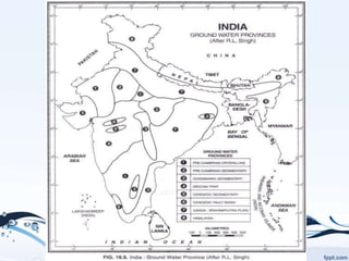
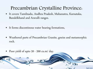
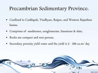
Groundwater Provinces in
India
U.S. Arvin Joshyn,
II - M.Sc. Applied Geology,
DEPT OF GEOLOGY
PERIYAR UNIVERSITY
SALEM , TAMILNADU
Introduction:
• Groundwater Province:
Groundwater province is an area or region in which geology
and climate combine to produce groundwater conditions consistent
enough to permit useful generalizations.
• The prevalent rock formations, ranging in age from the Archaean to the
recent, control the occurence & movement of groundwater.
• The topography and rainfall virtually control runoff and groundwater
recharge.
Introduction (Cont.)
• High relief areas - high runoff.
• Alluvial tract - high yielding aquifers.
• Peninsula - near surface weathered mantle.
• Hard rock terrain - deep weathered pediments, abandoned river
channels.
• Coastal, estuaries and deltaic tracts form linear strip around
peninsular India.
Significant factors control Ground
Water resources:
• Climate
• Relief features/ topography,
• Geological structures & hydrological setup.
Precambrian Crystalline Province:
• It covers Tamilnadu, Andhra Pradesh, Maharastra, Karnataka,
Bundelkhand and Aravalli ranges.
• It forms discontinous water bearing formations,
• Weathered parts of Precambrian Granite, gneiss and metamorphic
rock.
• Poor yield of upto 20 - 200 cu.m/ day.
Precambrian Sedimentary Province:
• Confined to Cuddapah, Vindhyan, Raipur, and Western Rajasthan
basins.
• Comprises of sandstones, conglomerate, limestone & slate,
• Rocks are compact and non porous,
• Secondary porosity yield water and the yield is 5 - 200 cu.m/ day
Gondwana Sedimentary Province:
• Barakar & Godavari river basins;
• Good in sandstone & poor in shale;
• Surrounded by crystalline rocks;
• Total formation - 6 - 7m thick;
• L. Gondwana - devoid of groundwater;
• U. Gondwana - good yield.
Deccan trap Province:
• 1200m thick impermeable basalt;
• Aquifers: i) structures by sec. porosity & fractures
ii) intertrappean beds
iii) contact zones b/w two beds, vesicles and amygdales.
Red boles yield water but cause problems during drilling.
Cenozoic Sedimentary Province:
• Tertiary sandtones of Tamilnadu, Andhra Pradesh, Kerala, Gujarat
coasts have good yield;
• In east coast seaward dipping strata contain several artesian
aquifers.
• Springs form along the hill tracts.
Cenozoic Fault Basin:
• Rift zones of Narmada, Purna & Tapti are good sources of GW
with 80 - 160m thick alluvial cover of sand, silt and clay.
Ganga- Brahmaputra alluvial
Province:
• Largest and rich GW province;
• Hard basements & slopes :10 - 30 degrees;
• 3 distinct belts:
– Bhabar of Talus material
– Tarai of water bearing gravel, sand & pebble with silt & clay;
– The axial belt comprising of stratified fine gravel deposited by river.
Yield upto 100 - 300 cu.m / hr.
Himalayan Higland Province:
• Highly folded and faulted sedimentary rocks of Palaeozoic to
Cenozoic.
• Sandstone, limestone & shale and their metamorphic equivalents.
• Traversed by gorges and valley of sediments and act as conduits
alluvial province.
• Springs are common; If alluvium is thick wells too forms to yield
100 - 200 cu.m /hr.
Thank you!

GROUNDWATER PROVINCES IN INDIA

  • 1.
    Groundwater Provinces in India U.S.Arvin Joshyn, II - M.Sc. Applied Geology, DEPT OF GEOLOGY PERIYAR UNIVERSITY SALEM , TAMILNADU
  • 2.
    Introduction: • Groundwater Province: Groundwaterprovince is an area or region in which geology and climate combine to produce groundwater conditions consistent enough to permit useful generalizations. • The prevalent rock formations, ranging in age from the Archaean to the recent, control the occurence & movement of groundwater. • The topography and rainfall virtually control runoff and groundwater recharge.
  • 3.
    Introduction (Cont.) • Highrelief areas - high runoff. • Alluvial tract - high yielding aquifers. • Peninsula - near surface weathered mantle. • Hard rock terrain - deep weathered pediments, abandoned river channels. • Coastal, estuaries and deltaic tracts form linear strip around peninsular India.
  • 4.
    Significant factors controlGround Water resources: • Climate • Relief features/ topography, • Geological structures & hydrological setup.
  • 6.
    Precambrian Crystalline Province: •It covers Tamilnadu, Andhra Pradesh, Maharastra, Karnataka, Bundelkhand and Aravalli ranges. • It forms discontinous water bearing formations, • Weathered parts of Precambrian Granite, gneiss and metamorphic rock. • Poor yield of upto 20 - 200 cu.m/ day.
  • 7.
    Precambrian Sedimentary Province: •Confined to Cuddapah, Vindhyan, Raipur, and Western Rajasthan basins. • Comprises of sandstones, conglomerate, limestone & slate, • Rocks are compact and non porous, • Secondary porosity yield water and the yield is 5 - 200 cu.m/ day
  • 8.
    Gondwana Sedimentary Province: •Barakar & Godavari river basins; • Good in sandstone & poor in shale; • Surrounded by crystalline rocks; • Total formation - 6 - 7m thick; • L. Gondwana - devoid of groundwater; • U. Gondwana - good yield.
  • 9.
    Deccan trap Province: •1200m thick impermeable basalt; • Aquifers: i) structures by sec. porosity & fractures ii) intertrappean beds iii) contact zones b/w two beds, vesicles and amygdales. Red boles yield water but cause problems during drilling.
  • 10.
    Cenozoic Sedimentary Province: •Tertiary sandtones of Tamilnadu, Andhra Pradesh, Kerala, Gujarat coasts have good yield; • In east coast seaward dipping strata contain several artesian aquifers. • Springs form along the hill tracts.
  • 11.
    Cenozoic Fault Basin: •Rift zones of Narmada, Purna & Tapti are good sources of GW with 80 - 160m thick alluvial cover of sand, silt and clay.
  • 12.
    Ganga- Brahmaputra alluvial Province: •Largest and rich GW province; • Hard basements & slopes :10 - 30 degrees; • 3 distinct belts: – Bhabar of Talus material – Tarai of water bearing gravel, sand & pebble with silt & clay; – The axial belt comprising of stratified fine gravel deposited by river. Yield upto 100 - 300 cu.m / hr.
  • 13.
    Himalayan Higland Province: •Highly folded and faulted sedimentary rocks of Palaeozoic to Cenozoic. • Sandstone, limestone & shale and their metamorphic equivalents. • Traversed by gorges and valley of sediments and act as conduits alluvial province. • Springs are common; If alluvium is thick wells too forms to yield 100 - 200 cu.m /hr.
  • 14.