Downloaded 182 times
![Appendices
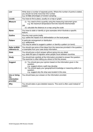
Command words and phrases used in Geography examination Papers
Examiners use command words to help you to understand what they are looking for in your
answers. This table explains what each of these words or phrases means and will help you to
understand the kind of answer you should write. The list of command words is in alphabetical
order. You should remember that the meaning of a term may vary slightly depending on how the
question is worded.
Annotate You have to add labels of notes or short comments to a diagram, map or
photograph. More than one word is needed.
Calculate You need to give a numerical answer. You should show your working,
especially where two or more steps are involved.
Compare You have to identify similarities and differences. Usually you need to look
carefully at two or more sets of data, places, features or geographical ideas,
then explain how they are similar and how they are different.
Complete You need to add the remaining details.
e.g. finish a graph using the data or finish a statement, which has been started
for you.
Define You need to state the meaning of something.
e.g. Longshore drift is the movement of material along the coast.
Describe You need to state the main points about something, (to say what it is like).
e.g. describe the movement of a pebble along a beach.
You may also be asked to describe:
• observations e.g. describe what is shown on the photograph
• patterns e.g. describe the change shown by the rainfall data
• processes e.g. describe how a waterfall is formed
Describe is often used with other command words.
e.g. Name and describe [name the feature and write the factual details of].
e.g. Describe and explain [set out the factual details and give reasons for].
Draw You should produce a simple line drawing. The most important points should
be shown and usually you should label them.
e.g. Draw and label a diagram to show a nucleated settlement.
Explain or (i) You have to give reasons for your answer.
Account for OR
(ii) refer to a particular geographical theory
e.g. explain why rainfall is higher in areas of high altitude
Factor You need to state what characteristics bring about a certain result
e.g. What factors influence the formation of rain?
Identify You have to recognise a specific feature or features shown, for example, on a
graph, photograph, map or text, e.g. identify the spit.
Illustrating (i) You should use specific examples or case studies to support your
your answer comments.
OR
(ii) You need to produce a labelled diagram to show the important points.
Insert or Label You should add specific names or details to show a feature or features.
IGCSE Geography 0460 Revision Checklist](https://image.slidesharecdn.com/revisionchecklistforigcsegeography-110921081258-phpapp02/85/Revision-checklist-for-igcse-geography-29-320.jpg)

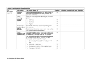
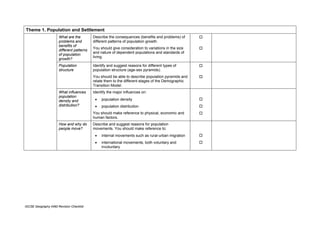
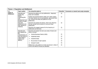
The document provides a revision checklist for IGCSE Geography students. It outlines the key topics and content that students need to know to prepare for their exams. The checklist is organized into three themes: population and settlement, the natural environment, and economic development. For each topic area, the checklist specifies the key details students should understand and provides space to check off topics once revised. It aims to help students systematically plan their revision and identify any gaps in knowledge.