Downloaded 162 times


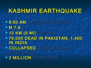


This document discusses seismic waves and seismicity in Pakistan. It describes the different types of seismic waves including body waves like P waves and S waves, and surface waves like Rayleigh and Love waves. Their velocities and properties are explained. The seismicity of Pakistan is then summarized, noting major earthquakes in 2005, 2008, and 2013 that caused significant damage. Seismic zoning maps divide Pakistan into risk areas based on earthquake data.


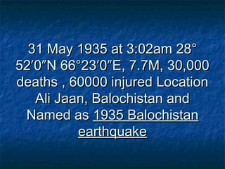
![EARTHQUAKE Presentation [TIPS 2]](https://cdn.slidesharecdn.com/ss_thumbnails/learningearthquakedesignfinal-140726123358-phpapp02-thumbnail.jpg?width=640&height=640&fit=bounds)


