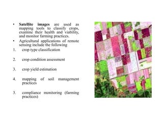
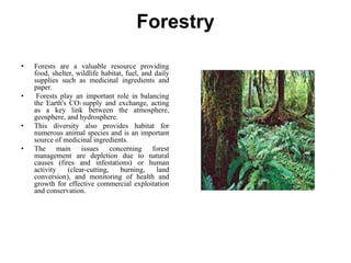
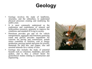
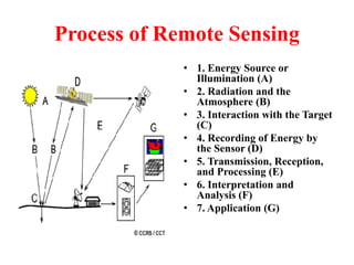
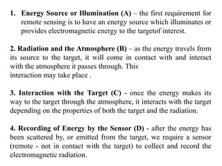
SlideShare a Scribd company logo
REMOTE SENSING
Contents
• What is Remote Sensing?
• Process of Remote Sensing
• Electromagnetic Radiations
• Electromagnetic Spectrum
• Interaction with Atmosphere
• Radiations-Target Interactions
• Passive Vs Active Sensing
What is Remote Sensing?
"Remote sensing is the science (and to
some extent, art) of acquiring information
about the Earth's surface without actually
being in contact with it.
This is done by sensing and recording
reflected or emitted energy and processing,
analyzing, and applying that information."
Process of Remote Sensing
• 1. Energy Source or
Illumination (A)
• 2. Radiation and the
Atmosphere (B)
• 3. Interaction with the Target
(C)
• 4. Recording of Energy by
the Sensor (D)
• 5. Transmission, Reception,
and Processing (E)
• 6. Interpretation and
Analysis (F)
• 7. Application (G)
1. Energy Source or Illumination (A) – the first requirement for
remote sensing is to have an energy source which illuminates or
provides electromagnetic energy to the targetof interest.
2. Radiation and the Atmosphere (B) – as the energy travels from
its source to the target, it will come in contact with and interact
with the atmosphere it passes through. This
interaction may take place .
3. Interaction with the Target (C) - once the energy makes its
way to the target through the atmosphere, it interacts with the target
depending on the properties of both the target and the radiation.
4. Recording of Energy by the Sensor (D) - after the energy has
been scattered by, or emitted from the target, we require a sensor
(remote - not in contact with the target) to collect and record the
electromagnetic radiation.
5. Transmission, Reception, and Processing (E) - the energy
recorded by the sensor has to be transmitted, often in electronic form,
to a receiving and processing station where the data are processed into
an image (hardcopy and/or digital).
6. Interpretation and Analysis (F) - the processed image is
interpreted, visually and/or digitally or electronically, to extract
information about the target which was illuminated.
7. Application (G) - the final element of the remote sensing process
is achieved when we apply the information we have been able to
extract from the imagery about the target in order to better understand
it, reveal some new information, or assist in solving a particular
problem.
Electromagnetic Radiation
• All electromagnetic radiation has
fundamental properties and
behaves in predictable ways
according to the basics of wave
theory.
• Electromagnetic radiation
consists of an electrical field(E)
which varies in magnitude in a
direction perpendicular to the
direction in which the radiation is
traveling, and a magnetic field
(M) oriented at right angles to the
electrical field. Both these fields
travel at the speed of light (c).
Applications of Remote Sensing
Agriculture
• The production of food is important to
everyone and producing food in a
cost-effective manner is the goal of
every farmer, large-scale farm
manager and regional agricultural
agency.
• These tools will help to understand
the health of crop, extent of infestation
or stress damage, or potential yield
and soil conditions.
• Commodity brokers are also very
interested in how well farms are
producing, as yield (both quantity and
quality) estimates for all products
control price and worldwide trading.
• Satellite images are used as
mapping tools to classify crops,
examine their health and viability,
and monitor farming practices.
• Agricultural applications of remote
sensing include the following
1. crop type classification
2. crop condition assessment
3. crop yield estimation
4. mapping of soil management
practices
3. compliance monitoring (farming
practices)
Forestry
• Forests are a valuable resource providing
food, shelter, wildlife habitat, fuel, and daily
supplies such as medicinal ingredients and
paper.
• Forests play an important role in balancing
the Earth's CO2 supply and exchange, acting
as a key link between the atmosphere,
geosphere, and hydrosphere.
• This diversity also provides habitat for
numerous animal species and is an important
source of medicinal ingredients.
• The main issues concerning forest
management are depletion due to natural
causes (fires and infestations) or human
activity (clear-cutting, burning, land
conversion), and monitoring of health and
growth for effective commercial exploitation
and conservation.
Forestry applications of remote sensing include the following:
1) Reconnaissance mapping
2) Commercial forestry
3) Clear cut mapping / regeneration assessment
4) Infrastructure mapping / operations support
5) Forest inventory
6) Biomass estimation
7) Species inventory
8) Environmental monitoring
Geology
• Geology involves the study of landforms,
structures, and the subsurface, to understand
physical processes creating and modifying the
earth's crust.
• It is most commonly understood as the
exploration and exploitation of mineral and
hydrocarbon resources, generally to improve the
conditions and standard of living in society.
• Petroleum provides gas and oil for vehicle
transportation, aggregate and limestone quarrying
(sand and gravel) provides ingredients for
concrete for paving and construction, potash
mines contribute to fertilizer, coal to energy
production, precious metals and gems for jewelry,
diamonds for drill bits, and copper, zinc and
assorted minerals for a variety of uses.
• Geology also includes the study of potential
hazards such as volcanoes, landslides, and earth
quakes, and is thus a critical factor for
geotechnical studies relating to construction and
engineering.
Geological applications of remote sensing include the
following:
Surficial deposit / bedrock mapping
Lithological mapping
Structural mapping
Sand and gravel (aggregate) exploration/ exploitation
Mineral exploration
Hydrocarbon exploration
Environmental geology
Baseline infrastructure
Sedimentation mapping and monitoring
Event mapping and monitoring
Geo-hazard mapping
Planetary mapping
Hydrology
• Hydrology is the study of
water on the Earth's surface,
whether flowing above
ground, frozen in ice or snow,
or retained by soil.
• Hydrology is inherently
related to many other
applications of remote
sensing, particularly forestry,
agriculture and land cover,
since water is a vital
component in each of these
disciplines.
Examples of hydrological applications include:
Wetlands mapping and monitoring
Soil moisture estimation
Snow pack monitoring / delineation of extent
Measuring snow thickness
Determining snow-water equivalent
River and lake ice monitoring
Flood mapping and monitoring
River /delta change detection
Drainage basin mapping and watershed modelling
Irigation canal leakage detection
Irrigation scheduling
Land Cover & Land Use
• Land use applications of remote sensing include the following:
• Natural resource management
• Wildlife habitat protection
• Baseline mapping for GIS input
• Urban expansion / encroachment
• Routing and logistics planning for seismic / exploration /
resource extraction activities
• Damage delineation (tornadoes, flooding, volcanic, seismic,
fire)
• Legal boundaries for tax and property evaluation
• Target detection - identification of landing strips, roads,
clearings, bridges, land/water interface
THANKS

More Related Content

What's hot

Thermal remote sensing
Thermal remote sensing   Thermal remote sensing
Thermal remote sensing
Rahat Malik
 
Remote Sensing Platforms and Sensors
Remote Sensing Platforms and SensorsRemote Sensing Platforms and Sensors
Remote Sensing Platforms and Sensors
Uday kumar Devalla
 
Remote Sensing For Environmental Impact And Monitoring
Remote Sensing For Environmental Impact And MonitoringRemote Sensing For Environmental Impact And Monitoring
Remote Sensing For Environmental Impact And Monitoring
PaulDavidShaw
 
Microwave remote sensing
Microwave remote sensingMicrowave remote sensing
Microwave remote sensing
Then Murugeshwari
 
Synthetic aperture radar
Synthetic aperture radar Synthetic aperture radar
Synthetic aperture radar
Cigi Cletus
 
Microwave remote sensing
Microwave remote sensingMicrowave remote sensing
Microwave remote sensing
Rohit Kumar
 
Basic of Remote Sensing
Basic of Remote SensingBasic of Remote Sensing
Basic of Remote Sensing
gueste5cfed
 
Remote sensing
Remote sensingRemote sensing
Remote sensing
Nishant Chaturvedi
 
Fundamentals of Remote Sensing
Fundamentals of Remote SensingFundamentals of Remote Sensing
Fundamentals of Remote Sensing
Shah Naseer
 
side-looking airborne radar
side-looking airborne radarside-looking airborne radar
side-looking airborne radar
Sneha Nalla
 
Indian Remote Sensing satellites (IRS).pptx
Indian Remote Sensing satellites (IRS).pptxIndian Remote Sensing satellites (IRS).pptx
Indian Remote Sensing satellites (IRS).pptx
sapna kinattinkara
 
Sensors for remote sensing
Sensors for remote sensingSensors for remote sensing
Sensors for remote sensing
Mohsin Siddique
 
Remote sensing
Remote sensingRemote sensing
Remote sensing
KU Leuven
 
MODIS
MODISMODIS
Remote sensing - Sensors, Platforms and Satellite orbits
Remote sensing - Sensors, Platforms and Satellite orbitsRemote sensing - Sensors, Platforms and Satellite orbits
Remote sensing - Sensors, Platforms and Satellite orbits
Ajay Singh Lodhi
 
INTRODUCTION TO REMOTE SENSING
 INTRODUCTION TO REMOTE SENSING INTRODUCTION TO REMOTE SENSING
INTRODUCTION TO REMOTE SENSING
Ghassan Hadi
 
Geo synchronous and Sun synchronous Satellites
Geo synchronous and Sun synchronous SatellitesGeo synchronous and Sun synchronous Satellites
Geo synchronous and Sun synchronous Satellites
Tilok Chetri
 
Remote sensing and image interpretation
Remote sensing and image interpretationRemote sensing and image interpretation
Remote sensing and image interpretation
Md. Nazir Hossain
 
Thermal remote sensing and its applications
Thermal remote sensing and its applicationsThermal remote sensing and its applications
Thermal remote sensing and its applications
chandan00781
 
Microwave remote sensing
Microwave remote sensingMicrowave remote sensing
Microwave remote sensing
Mohsin Siddique
 

What's hot (20)

Thermal remote sensing
Thermal remote sensing   Thermal remote sensing
Thermal remote sensing
 
Remote Sensing Platforms and Sensors
Remote Sensing Platforms and SensorsRemote Sensing Platforms and Sensors
Remote Sensing Platforms and Sensors
 
Remote Sensing For Environmental Impact And Monitoring
Remote Sensing For Environmental Impact And MonitoringRemote Sensing For Environmental Impact And Monitoring
Remote Sensing For Environmental Impact And Monitoring
 
Microwave remote sensing
Microwave remote sensingMicrowave remote sensing
Microwave remote sensing
 
Synthetic aperture radar
Synthetic aperture radar Synthetic aperture radar
Synthetic aperture radar
 
Microwave remote sensing
Microwave remote sensingMicrowave remote sensing
Microwave remote sensing
 
Basic of Remote Sensing
Basic of Remote SensingBasic of Remote Sensing
Basic of Remote Sensing
 
Remote sensing
Remote sensingRemote sensing
Remote sensing
 
Fundamentals of Remote Sensing
Fundamentals of Remote SensingFundamentals of Remote Sensing
Fundamentals of Remote Sensing
 
side-looking airborne radar
side-looking airborne radarside-looking airborne radar
side-looking airborne radar
 
Indian Remote Sensing satellites (IRS).pptx
Indian Remote Sensing satellites (IRS).pptxIndian Remote Sensing satellites (IRS).pptx
Indian Remote Sensing satellites (IRS).pptx
 
Sensors for remote sensing
Sensors for remote sensingSensors for remote sensing
Sensors for remote sensing
 
Remote sensing
Remote sensingRemote sensing
Remote sensing
 
MODIS
MODISMODIS
MODIS
 
Remote sensing - Sensors, Platforms and Satellite orbits
Remote sensing - Sensors, Platforms and Satellite orbitsRemote sensing - Sensors, Platforms and Satellite orbits
Remote sensing - Sensors, Platforms and Satellite orbits
 
INTRODUCTION TO REMOTE SENSING
 INTRODUCTION TO REMOTE SENSING INTRODUCTION TO REMOTE SENSING
INTRODUCTION TO REMOTE SENSING
 
Geo synchronous and Sun synchronous Satellites
Geo synchronous and Sun synchronous SatellitesGeo synchronous and Sun synchronous Satellites
Geo synchronous and Sun synchronous Satellites
 
Remote sensing and image interpretation
Remote sensing and image interpretationRemote sensing and image interpretation
Remote sensing and image interpretation
 
Thermal remote sensing and its applications
Thermal remote sensing and its applicationsThermal remote sensing and its applications
Thermal remote sensing and its applications
 
Microwave remote sensing
Microwave remote sensingMicrowave remote sensing
Microwave remote sensing
 

Similar to Remote Sensing Presentation

applicationsofremotesensingingeologicalaspects-170606133459.pdf
applicationsofremotesensingingeologicalaspects-170606133459.pdfapplicationsofremotesensingingeologicalaspects-170606133459.pdf
applicationsofremotesensingingeologicalaspects-170606133459.pdf
CIVIL48
 
Applications of remote sensing in geological aspects
Applications of remote sensing in geological aspectsApplications of remote sensing in geological aspects
Applications of remote sensing in geological aspects
Pramoda Raj
 
Soil mapping , remote sensing and use of sensors in precision farming
Soil mapping , remote sensing and use of  sensors in precision farmingSoil mapping , remote sensing and use of  sensors in precision farming
Soil mapping , remote sensing and use of sensors in precision farming
Dr. M. Kumaresan Hort.
 
Remote sensing and tunneling.pptx
Remote sensing and tunneling.pptxRemote sensing and tunneling.pptx
Remote sensing and tunneling.pptx
pandieswarim1
 
Lec (remote sensing).pptx
Lec (remote sensing).pptxLec (remote sensing).pptx
Lec (remote sensing).pptx
SarfrazFaiz
 
Iirs lecure notes for Remote sensing –An Overview of Decision Maker
Iirs lecure notes for Remote sensing –An Overview of Decision MakerIirs lecure notes for Remote sensing –An Overview of Decision Maker
Iirs lecure notes for Remote sensing –An Overview of Decision Maker
Tushar Dholakia
 
Remote sensing
Remote sensingRemote sensing
Remote sensing
Pankaj602604
 
Remote sensing in space krishna
Remote sensing in space krishnaRemote sensing in space krishna
Remote sensing in space krishna
Krishna Gaihre
 
Remote sensing
 Remote sensing Remote sensing
Remort sensing
Remort sensingRemort sensing
Remort sensing
JoynalAbedin20
 
Assessing stress by using remote sensing
Assessing stress by using remote sensingAssessing stress by using remote sensing
Assessing stress by using remote sensing
Chongtham Allaylay Devi
 
Description Working of Remote sensing and GIS .pptx
Description Working of  Remote sensing and GIS .pptxDescription Working of  Remote sensing and GIS .pptx
Description Working of Remote sensing and GIS .pptx
needall851
 
1 remote sensing
1 remote sensing1 remote sensing
1 remote sensing
Dr Zubairul Islam
 
Fiu overview microbes_2014
Fiu overview microbes_2014Fiu overview microbes_2014
Fiu overview microbes_2014
jjparnell
 
intro.pptx
intro.pptxintro.pptx
Principles of remote sensing
Principles of remote sensingPrinciples of remote sensing
Principles of remote sensing
Pramoda Raj
 
Remote sensing and application by Nikhil Pakwanne
Remote sensing and application by Nikhil PakwanneRemote sensing and application by Nikhil Pakwanne
Remote sensing and application by Nikhil Pakwanne
NIKHIL PAKWANNE
 
Remote sensing in Civil Engineering
Remote sensing in Civil EngineeringRemote sensing in Civil Engineering
Remote sensing in Civil Engineering
Manishkumar Dubey
 
Remote sensing and gis ppt
Remote sensing and gis pptRemote sensing and gis ppt
Remote sensing and gis ppt
preeti patil
 
Identification Of Ground Water Potential Zones In Tamil Nadu By Remote Sensin...
Identification Of Ground Water Potential Zones In Tamil Nadu By Remote Sensin...Identification Of Ground Water Potential Zones In Tamil Nadu By Remote Sensin...
Identification Of Ground Water Potential Zones In Tamil Nadu By Remote Sensin...
IJERA Editor
 

Similar to Remote Sensing Presentation (20)

applicationsofremotesensingingeologicalaspects-170606133459.pdf
applicationsofremotesensingingeologicalaspects-170606133459.pdfapplicationsofremotesensingingeologicalaspects-170606133459.pdf
applicationsofremotesensingingeologicalaspects-170606133459.pdf
 
Applications of remote sensing in geological aspects
Applications of remote sensing in geological aspectsApplications of remote sensing in geological aspects
Applications of remote sensing in geological aspects
 
Soil mapping , remote sensing and use of sensors in precision farming
Soil mapping , remote sensing and use of  sensors in precision farmingSoil mapping , remote sensing and use of  sensors in precision farming
Soil mapping , remote sensing and use of sensors in precision farming
 
Remote sensing and tunneling.pptx
Remote sensing and tunneling.pptxRemote sensing and tunneling.pptx
Remote sensing and tunneling.pptx
 
Lec (remote sensing).pptx
Lec (remote sensing).pptxLec (remote sensing).pptx
Lec (remote sensing).pptx
 
Iirs lecure notes for Remote sensing –An Overview of Decision Maker
Iirs lecure notes for Remote sensing –An Overview of Decision MakerIirs lecure notes for Remote sensing –An Overview of Decision Maker
Iirs lecure notes for Remote sensing –An Overview of Decision Maker
 
Remote sensing
Remote sensingRemote sensing
Remote sensing
 
Remote sensing in space krishna
Remote sensing in space krishnaRemote sensing in space krishna
Remote sensing in space krishna
 
Remote sensing
 Remote sensing Remote sensing
Remote sensing
 
Remort sensing
Remort sensingRemort sensing
Remort sensing
 
Assessing stress by using remote sensing
Assessing stress by using remote sensingAssessing stress by using remote sensing
Assessing stress by using remote sensing
 
Description Working of Remote sensing and GIS .pptx
Description Working of  Remote sensing and GIS .pptxDescription Working of  Remote sensing and GIS .pptx
Description Working of Remote sensing and GIS .pptx
 
1 remote sensing
1 remote sensing1 remote sensing
1 remote sensing
 
Fiu overview microbes_2014
Fiu overview microbes_2014Fiu overview microbes_2014
Fiu overview microbes_2014
 
intro.pptx
intro.pptxintro.pptx
intro.pptx
 
Principles of remote sensing
Principles of remote sensingPrinciples of remote sensing
Principles of remote sensing
 
Remote sensing and application by Nikhil Pakwanne
Remote sensing and application by Nikhil PakwanneRemote sensing and application by Nikhil Pakwanne
Remote sensing and application by Nikhil Pakwanne
 
Remote sensing in Civil Engineering
Remote sensing in Civil EngineeringRemote sensing in Civil Engineering
Remote sensing in Civil Engineering
 
Remote sensing and gis ppt
Remote sensing and gis pptRemote sensing and gis ppt
Remote sensing and gis ppt
 
Identification Of Ground Water Potential Zones In Tamil Nadu By Remote Sensin...
Identification Of Ground Water Potential Zones In Tamil Nadu By Remote Sensin...Identification Of Ground Water Potential Zones In Tamil Nadu By Remote Sensin...
Identification Of Ground Water Potential Zones In Tamil Nadu By Remote Sensin...
 

Recently uploaded

Digital Artefact 1 - Tiny Home Environmental Design
Digital Artefact 1 - Tiny Home Environmental DesignDigital Artefact 1 - Tiny Home Environmental Design
Digital Artefact 1 - Tiny Home Environmental Design
amberjdewit93
 
PCOS corelations and management through Ayurveda.
PCOS corelations and management through Ayurveda.PCOS corelations and management through Ayurveda.
PCOS corelations and management through Ayurveda.
Dr. Shivangi Singh Parihar
 
Hindi varnamala | hindi alphabet PPT.pdf
Hindi varnamala | hindi alphabet PPT.pdfHindi varnamala | hindi alphabet PPT.pdf
Hindi varnamala | hindi alphabet PPT.pdf
Dr. Mulla Adam Ali
 
How to Fix the Import Error in the Odoo 17
How to Fix the Import Error in the Odoo 17How to Fix the Import Error in the Odoo 17
How to Fix the Import Error in the Odoo 17
Celine George
 
MARY JANE WILSON, A “BOA MÃE” .
MARY JANE WILSON, A “BOA MÃE”           .MARY JANE WILSON, A “BOA MÃE”           .
MARY JANE WILSON, A “BOA MÃE” .
Colégio Santa Teresinha
 
BÀI TẬP BỔ TRỢ TIẾNG ANH LỚP 9 CẢ NĂM - GLOBAL SUCCESS - NĂM HỌC 2024-2025 - ...
BÀI TẬP BỔ TRỢ TIẾNG ANH LỚP 9 CẢ NĂM - GLOBAL SUCCESS - NĂM HỌC 2024-2025 - ...BÀI TẬP BỔ TRỢ TIẾNG ANH LỚP 9 CẢ NĂM - GLOBAL SUCCESS - NĂM HỌC 2024-2025 - ...
BÀI TẬP BỔ TRỢ TIẾNG ANH LỚP 9 CẢ NĂM - GLOBAL SUCCESS - NĂM HỌC 2024-2025 - ...
Nguyen Thanh Tu Collection
 
LAND USE LAND COVER AND NDVI OF MIRZAPUR DISTRICT, UP
LAND USE LAND COVER AND NDVI OF MIRZAPUR DISTRICT, UPLAND USE LAND COVER AND NDVI OF MIRZAPUR DISTRICT, UP
LAND USE LAND COVER AND NDVI OF MIRZAPUR DISTRICT, UP
RAHUL
 
Wound healing PPT
Wound healing PPTWound healing PPT
Wound healing PPT
Jyoti Chand
 
How to Build a Module in Odoo 17 Using the Scaffold Method
How to Build a Module in Odoo 17 Using the Scaffold MethodHow to Build a Module in Odoo 17 Using the Scaffold Method
How to Build a Module in Odoo 17 Using the Scaffold Method
Celine George
 
How to Setup Warehouse & Location in Odoo 17 Inventory
How to Setup Warehouse & Location in Odoo 17 InventoryHow to Setup Warehouse & Location in Odoo 17 Inventory
How to Setup Warehouse & Location in Odoo 17 Inventory
Celine George
 
Présentationvvvvvvvvvvvvvvvvvvvvvvvvvvvv2.pptx
Présentationvvvvvvvvvvvvvvvvvvvvvvvvvvvv2.pptxPrésentationvvvvvvvvvvvvvvvvvvvvvvvvvvvv2.pptx
Présentationvvvvvvvvvvvvvvvvvvvvvvvvvvvv2.pptx
siemaillard
 
Life upper-Intermediate B2 Workbook for student
Life upper-Intermediate B2 Workbook for studentLife upper-Intermediate B2 Workbook for student
Life upper-Intermediate B2 Workbook for student
NgcHiNguyn25
 
বাংলাদেশ অর্থনৈতিক সমীক্ষা (Economic Review) ২০২৪ UJS App.pdf
বাংলাদেশ অর্থনৈতিক সমীক্ষা (Economic Review) ২০২৪ UJS App.pdfবাংলাদেশ অর্থনৈতিক সমীক্ষা (Economic Review) ২০২৪ UJS App.pdf
বাংলাদেশ অর্থনৈতিক সমীক্ষা (Economic Review) ২০২৪ UJS App.pdf
eBook.com.bd (প্রয়োজনীয় বাংলা বই)
 
clinical examination of hip joint (1).pdf
clinical examination of hip joint (1).pdfclinical examination of hip joint (1).pdf
clinical examination of hip joint (1).pdf
Priyankaranawat4
 
What is Digital Literacy? A guest blog from Andy McLaughlin, University of Ab...
What is Digital Literacy? A guest blog from Andy McLaughlin, University of Ab...What is Digital Literacy? A guest blog from Andy McLaughlin, University of Ab...
What is Digital Literacy? A guest blog from Andy McLaughlin, University of Ab...
GeorgeMilliken2
 
The History of Stoke Newington Street Names
The History of Stoke Newington Street NamesThe History of Stoke Newington Street Names
The History of Stoke Newington Street Names
History of Stoke Newington
 
BBR 2024 Summer Sessions Interview Training
BBR  2024 Summer Sessions Interview TrainingBBR  2024 Summer Sessions Interview Training
BBR 2024 Summer Sessions Interview Training
Katrina Pritchard
 
Reimagining Your Library Space: How to Increase the Vibes in Your Library No ...
Reimagining Your Library Space: How to Increase the Vibes in Your Library No ...Reimagining Your Library Space: How to Increase the Vibes in Your Library No ...
Reimagining Your Library Space: How to Increase the Vibes in Your Library No ...
Diana Rendina
 
The basics of sentences session 6pptx.pptx
The basics of sentences session 6pptx.pptxThe basics of sentences session 6pptx.pptx
The basics of sentences session 6pptx.pptx
heathfieldcps1
 
How to deliver Powerpoint Presentations.pptx
How to deliver Powerpoint  Presentations.pptxHow to deliver Powerpoint  Presentations.pptx
How to deliver Powerpoint Presentations.pptx
HajraNaeem15
 

Recently uploaded (20)

Digital Artefact 1 - Tiny Home Environmental Design
Digital Artefact 1 - Tiny Home Environmental DesignDigital Artefact 1 - Tiny Home Environmental Design
Digital Artefact 1 - Tiny Home Environmental Design
 
PCOS corelations and management through Ayurveda.
PCOS corelations and management through Ayurveda.PCOS corelations and management through Ayurveda.
PCOS corelations and management through Ayurveda.
 
Hindi varnamala | hindi alphabet PPT.pdf
Hindi varnamala | hindi alphabet PPT.pdfHindi varnamala | hindi alphabet PPT.pdf
Hindi varnamala | hindi alphabet PPT.pdf
 
How to Fix the Import Error in the Odoo 17
How to Fix the Import Error in the Odoo 17How to Fix the Import Error in the Odoo 17
How to Fix the Import Error in the Odoo 17
 
MARY JANE WILSON, A “BOA MÃE” .
MARY JANE WILSON, A “BOA MÃE”           .MARY JANE WILSON, A “BOA MÃE”           .
MARY JANE WILSON, A “BOA MÃE” .
 
BÀI TẬP BỔ TRỢ TIẾNG ANH LỚP 9 CẢ NĂM - GLOBAL SUCCESS - NĂM HỌC 2024-2025 - ...
BÀI TẬP BỔ TRỢ TIẾNG ANH LỚP 9 CẢ NĂM - GLOBAL SUCCESS - NĂM HỌC 2024-2025 - ...BÀI TẬP BỔ TRỢ TIẾNG ANH LỚP 9 CẢ NĂM - GLOBAL SUCCESS - NĂM HỌC 2024-2025 - ...
BÀI TẬP BỔ TRỢ TIẾNG ANH LỚP 9 CẢ NĂM - GLOBAL SUCCESS - NĂM HỌC 2024-2025 - ...
 
LAND USE LAND COVER AND NDVI OF MIRZAPUR DISTRICT, UP
LAND USE LAND COVER AND NDVI OF MIRZAPUR DISTRICT, UPLAND USE LAND COVER AND NDVI OF MIRZAPUR DISTRICT, UP
LAND USE LAND COVER AND NDVI OF MIRZAPUR DISTRICT, UP
 
Wound healing PPT
Wound healing PPTWound healing PPT
Wound healing PPT
 
How to Build a Module in Odoo 17 Using the Scaffold Method
How to Build a Module in Odoo 17 Using the Scaffold MethodHow to Build a Module in Odoo 17 Using the Scaffold Method
How to Build a Module in Odoo 17 Using the Scaffold Method
 
How to Setup Warehouse & Location in Odoo 17 Inventory
How to Setup Warehouse & Location in Odoo 17 InventoryHow to Setup Warehouse & Location in Odoo 17 Inventory
How to Setup Warehouse & Location in Odoo 17 Inventory
 
Présentationvvvvvvvvvvvvvvvvvvvvvvvvvvvv2.pptx
Présentationvvvvvvvvvvvvvvvvvvvvvvvvvvvv2.pptxPrésentationvvvvvvvvvvvvvvvvvvvvvvvvvvvv2.pptx
Présentationvvvvvvvvvvvvvvvvvvvvvvvvvvvv2.pptx
 
Life upper-Intermediate B2 Workbook for student
Life upper-Intermediate B2 Workbook for studentLife upper-Intermediate B2 Workbook for student
Life upper-Intermediate B2 Workbook for student
 
বাংলাদেশ অর্থনৈতিক সমীক্ষা (Economic Review) ২০২৪ UJS App.pdf
বাংলাদেশ অর্থনৈতিক সমীক্ষা (Economic Review) ২০২৪ UJS App.pdfবাংলাদেশ অর্থনৈতিক সমীক্ষা (Economic Review) ২০২৪ UJS App.pdf
বাংলাদেশ অর্থনৈতিক সমীক্ষা (Economic Review) ২০২৪ UJS App.pdf
 
clinical examination of hip joint (1).pdf
clinical examination of hip joint (1).pdfclinical examination of hip joint (1).pdf
clinical examination of hip joint (1).pdf
 
What is Digital Literacy? A guest blog from Andy McLaughlin, University of Ab...
What is Digital Literacy? A guest blog from Andy McLaughlin, University of Ab...What is Digital Literacy? A guest blog from Andy McLaughlin, University of Ab...
What is Digital Literacy? A guest blog from Andy McLaughlin, University of Ab...
 
The History of Stoke Newington Street Names
The History of Stoke Newington Street NamesThe History of Stoke Newington Street Names
The History of Stoke Newington Street Names
 
BBR 2024 Summer Sessions Interview Training
BBR  2024 Summer Sessions Interview TrainingBBR  2024 Summer Sessions Interview Training
BBR 2024 Summer Sessions Interview Training
 
Reimagining Your Library Space: How to Increase the Vibes in Your Library No ...
Reimagining Your Library Space: How to Increase the Vibes in Your Library No ...Reimagining Your Library Space: How to Increase the Vibes in Your Library No ...
Reimagining Your Library Space: How to Increase the Vibes in Your Library No ...
 
The basics of sentences session 6pptx.pptx
The basics of sentences session 6pptx.pptxThe basics of sentences session 6pptx.pptx
The basics of sentences session 6pptx.pptx
 
How to deliver Powerpoint Presentations.pptx
How to deliver Powerpoint  Presentations.pptxHow to deliver Powerpoint  Presentations.pptx
How to deliver Powerpoint Presentations.pptx
 

Remote Sensing Presentation

  • 2. Contents • What is Remote Sensing? • Process of Remote Sensing • Electromagnetic Radiations • Electromagnetic Spectrum • Interaction with Atmosphere • Radiations-Target Interactions • Passive Vs Active Sensing
  • 3. What is Remote Sensing? "Remote sensing is the science (and to some extent, art) of acquiring information about the Earth's surface without actually being in contact with it. This is done by sensing and recording reflected or emitted energy and processing, analyzing, and applying that information."
  • 4. Process of Remote Sensing • 1. Energy Source or Illumination (A) • 2. Radiation and the Atmosphere (B) • 3. Interaction with the Target (C) • 4. Recording of Energy by the Sensor (D) • 5. Transmission, Reception, and Processing (E) • 6. Interpretation and Analysis (F) • 7. Application (G)
  • 5. 1. Energy Source or Illumination (A) – the first requirement for remote sensing is to have an energy source which illuminates or provides electromagnetic energy to the targetof interest. 2. Radiation and the Atmosphere (B) – as the energy travels from its source to the target, it will come in contact with and interact with the atmosphere it passes through. This interaction may take place . 3. Interaction with the Target (C) - once the energy makes its way to the target through the atmosphere, it interacts with the target depending on the properties of both the target and the radiation. 4. Recording of Energy by the Sensor (D) - after the energy has been scattered by, or emitted from the target, we require a sensor (remote - not in contact with the target) to collect and record the electromagnetic radiation.
  • 6. 5. Transmission, Reception, and Processing (E) - the energy recorded by the sensor has to be transmitted, often in electronic form, to a receiving and processing station where the data are processed into an image (hardcopy and/or digital). 6. Interpretation and Analysis (F) - the processed image is interpreted, visually and/or digitally or electronically, to extract information about the target which was illuminated. 7. Application (G) - the final element of the remote sensing process is achieved when we apply the information we have been able to extract from the imagery about the target in order to better understand it, reveal some new information, or assist in solving a particular problem.
  • 7. Electromagnetic Radiation • All electromagnetic radiation has fundamental properties and behaves in predictable ways according to the basics of wave theory. • Electromagnetic radiation consists of an electrical field(E) which varies in magnitude in a direction perpendicular to the direction in which the radiation is traveling, and a magnetic field (M) oriented at right angles to the electrical field. Both these fields travel at the speed of light (c).
  • 9. Agriculture • The production of food is important to everyone and producing food in a cost-effective manner is the goal of every farmer, large-scale farm manager and regional agricultural agency. • These tools will help to understand the health of crop, extent of infestation or stress damage, or potential yield and soil conditions. • Commodity brokers are also very interested in how well farms are producing, as yield (both quantity and quality) estimates for all products control price and worldwide trading.
  • 10. • Satellite images are used as mapping tools to classify crops, examine their health and viability, and monitor farming practices. • Agricultural applications of remote sensing include the following 1. crop type classification 2. crop condition assessment 3. crop yield estimation 4. mapping of soil management practices 3. compliance monitoring (farming practices)
  • 11. Forestry • Forests are a valuable resource providing food, shelter, wildlife habitat, fuel, and daily supplies such as medicinal ingredients and paper. • Forests play an important role in balancing the Earth's CO2 supply and exchange, acting as a key link between the atmosphere, geosphere, and hydrosphere. • This diversity also provides habitat for numerous animal species and is an important source of medicinal ingredients. • The main issues concerning forest management are depletion due to natural causes (fires and infestations) or human activity (clear-cutting, burning, land conversion), and monitoring of health and growth for effective commercial exploitation and conservation.
  • 12. Forestry applications of remote sensing include the following: 1) Reconnaissance mapping 2) Commercial forestry 3) Clear cut mapping / regeneration assessment 4) Infrastructure mapping / operations support 5) Forest inventory 6) Biomass estimation 7) Species inventory 8) Environmental monitoring
  • 13. Geology • Geology involves the study of landforms, structures, and the subsurface, to understand physical processes creating and modifying the earth's crust. • It is most commonly understood as the exploration and exploitation of mineral and hydrocarbon resources, generally to improve the conditions and standard of living in society. • Petroleum provides gas and oil for vehicle transportation, aggregate and limestone quarrying (sand and gravel) provides ingredients for concrete for paving and construction, potash mines contribute to fertilizer, coal to energy production, precious metals and gems for jewelry, diamonds for drill bits, and copper, zinc and assorted minerals for a variety of uses. • Geology also includes the study of potential hazards such as volcanoes, landslides, and earth quakes, and is thus a critical factor for geotechnical studies relating to construction and engineering.
  • 14. Geological applications of remote sensing include the following: Surficial deposit / bedrock mapping Lithological mapping Structural mapping Sand and gravel (aggregate) exploration/ exploitation Mineral exploration Hydrocarbon exploration Environmental geology Baseline infrastructure Sedimentation mapping and monitoring Event mapping and monitoring Geo-hazard mapping Planetary mapping
  • 15. Hydrology • Hydrology is the study of water on the Earth's surface, whether flowing above ground, frozen in ice or snow, or retained by soil. • Hydrology is inherently related to many other applications of remote sensing, particularly forestry, agriculture and land cover, since water is a vital component in each of these disciplines.
  • 16. Examples of hydrological applications include: Wetlands mapping and monitoring Soil moisture estimation Snow pack monitoring / delineation of extent Measuring snow thickness Determining snow-water equivalent River and lake ice monitoring Flood mapping and monitoring River /delta change detection Drainage basin mapping and watershed modelling Irigation canal leakage detection Irrigation scheduling
  • 17. Land Cover & Land Use • Land use applications of remote sensing include the following: • Natural resource management • Wildlife habitat protection • Baseline mapping for GIS input • Urban expansion / encroachment • Routing and logistics planning for seismic / exploration / resource extraction activities • Damage delineation (tornadoes, flooding, volcanic, seismic, fire) • Legal boundaries for tax and property evaluation • Target detection - identification of landing strips, roads, clearings, bridges, land/water interface