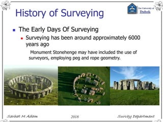
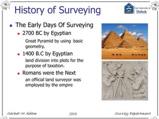
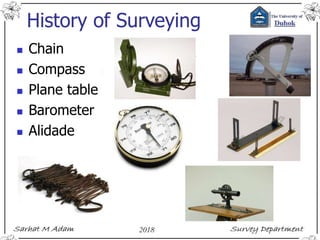
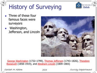
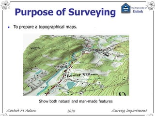
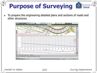
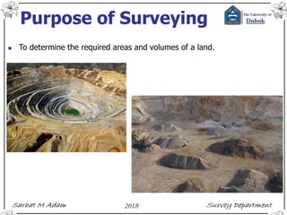
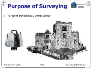
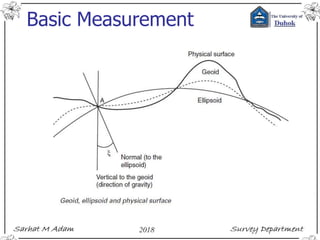
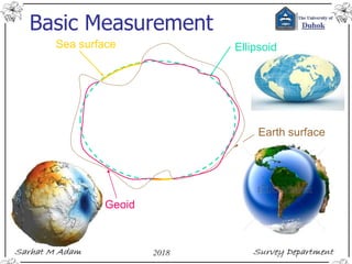
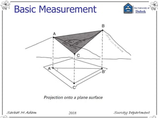
This ppt presentation covers compass surveying, which explains principal of compass surveying, Types of compass, Difference between compass, Bearing, Definitions related to compass surveying etc.
What is a Total Station?
Capability of a Total Station
Important Operations of Total Station
Uses of Total Station
Advantages of Using Total Stations
Applications
Content- Introduction to surveying and leveling
Object and Uses of Surveying, Fundamental Principles of Surveying, Introduction to conventional methods and equipment used for surveying and Leveling
Introduction to modern equipment’s used in surveying- EDM, Total Station, GIS,GPS, Remote sensing, planimeter.
Introduction to Topo sheets and use of maps.
Introduction, electromagnetic spectrum, electromagnetic distance measurement, types of EDM instruments, electronic digital theodolites, total station, digital levels, scanners for topographical survey, global positioning system.
Edm is a surveying instrument used to measure the distance electronically. This Surveying Instrument is used in triangulation to measure the length of Base line because more accuracy is required to measure the length of base line.
Definition of Surveying
Objects of Surveying
Uses of Surveying
Primary Divisions of Surveying
Principles of Surveying
List of Classification of Surveying
Definitions : Plan and Map, scales :Plain Scale and Diagonal Scale,
Course Contents:
Introduction; Linear measurements; Analysis and adjustment of measurements, Survey methods: coordinate systems, bearings, horizontal control, traversing, triangulation, detail surveying; Orientation and position; Areas and volumes; Setting out; Curve ranging; Global Positioning system (GPS); Photogrammetry.
The Global Positioning System is a satellite-based radio navigation system for determination of precise position and time, using radio signals from the satellites, in real-time or in post-processing mode.
Engineering surveying, 5...ition w. schofieldrnkhan
An important book for knowledge of all types of engineering surveys
Engineering Surveying. Sixth Edition. W. Schofield. Former Principal Lecturer, Kingston University. M. Breach. Principal Lecturer, Nottingham Trent University.
Development of Methodology for Determining Earth Work Volume Using Combined S...IJMER
International Journal of Modern Engineering Research (IJMER) is Peer reviewed, online Journal. It serves as an international archival forum of scholarly research related to engineering and science education.
International Journal of Modern Engineering Research (IJMER) covers all the fields of engineering and science: Electrical Engineering, Mechanical Engineering, Civil Engineering, Chemical Engineering, Computer Engineering, Agricultural Engineering, Aerospace Engineering, Thermodynamics, Structural Engineering, Control Engineering, Robotics, Mechatronics, Fluid Mechanics, Nanotechnology, Simulators, Web-based Learning, Remote Laboratories, Engineering Design Methods, Education Research, Students' Satisfaction and Motivation, Global Projects, and Assessment…. And many more.
Errors and Uncertainty are parts of surveying. These slides start first by defining scale and measurements, then show how to determine the uncertainty in measurements. For making these slides I used some books as well; Surveying_Engineering Surveying 6th edition, Surveying Problem Solving, & Surevying_Elemntary Surveying an introduction to Geomatics_Paul R. Wolf.
NO1 Uk best vashikaran specialist in delhi vashikaran baba near me online vas...Amil Baba Dawood bangali
Contact with Dawood Bhai Just call on +92322-6382012 and we'll help you. We'll solve all your problems within 12 to 24 hours and with 101% guarantee and with astrology systematic. If you want to take any personal or professional advice then also you can call us on +92322-6382012 , ONLINE LOVE PROBLEM & Other all types of Daily Life Problem's.Then CALL or WHATSAPP us on +92322-6382012 and Get all these problems solutions here by Amil Baba DAWOOD BANGALI
#vashikaranspecialist #astrologer #palmistry #amliyaat #taweez #manpasandshadi #horoscope #spiritual #lovelife #lovespell #marriagespell#aamilbabainpakistan #amilbabainkarachi #powerfullblackmagicspell #kalajadumantarspecialist #realamilbaba #AmilbabainPakistan #astrologerincanada #astrologerindubai #lovespellsmaster #kalajaduspecialist #lovespellsthatwork #aamilbabainlahore#blackmagicformarriage #aamilbaba #kalajadu #kalailam #taweez #wazifaexpert #jadumantar #vashikaranspecialist #astrologer #palmistry #amliyaat #taweez #manpasandshadi #horoscope #spiritual #lovelife #lovespell #marriagespell#aamilbabainpakistan #amilbabainkarachi #powerfullblackmagicspell #kalajadumantarspecialist #realamilbaba #AmilbabainPakistan #astrologerincanada #astrologerindubai #lovespellsmaster #kalajaduspecialist #lovespellsthatwork #aamilbabainlahore #blackmagicforlove #blackmagicformarriage #aamilbaba #kalajadu #kalailam #taweez #wazifaexpert #jadumantar #vashikaranspecialist #astrologer #palmistry #amliyaat #taweez #manpasandshadi #horoscope #spiritual #lovelife #lovespell #marriagespell#aamilbabainpakistan #amilbabainkarachi #powerfullblackmagicspell #kalajadumantarspecialist #realamilbaba #AmilbabainPakistan #astrologerincanada #astrologerindubai #lovespellsmaster #kalajaduspecialist #lovespellsthatwork #aamilbabainlahore #Amilbabainuk #amilbabainspain #amilbabaindubai #Amilbabainnorway #amilbabainkrachi #amilbabainlahore #amilbabaingujranwalan #amilbabainislamabad
Explore the innovative world of trenchless pipe repair with our comprehensive guide, "The Benefits and Techniques of Trenchless Pipe Repair." This document delves into the modern methods of repairing underground pipes without the need for extensive excavation, highlighting the numerous advantages and the latest techniques used in the industry.
Learn about the cost savings, reduced environmental impact, and minimal disruption associated with trenchless technology. Discover detailed explanations of popular techniques such as pipe bursting, cured-in-place pipe (CIPP) lining, and directional drilling. Understand how these methods can be applied to various types of infrastructure, from residential plumbing to large-scale municipal systems.
Ideal for homeowners, contractors, engineers, and anyone interested in modern plumbing solutions, this guide provides valuable insights into why trenchless pipe repair is becoming the preferred choice for pipe rehabilitation. Stay informed about the latest advancements and best practices in the field.
Immunizing Image Classifiers Against Localized Adversary Attacksgerogepatton
This paper addresses the vulnerability of deep learning models, particularly convolutional neural networks
(CNN)s, to adversarial attacks and presents a proactive training technique designed to counter them. We
introduce a novel volumization algorithm, which transforms 2D images into 3D volumetric representations.
When combined with 3D convolution and deep curriculum learning optimization (CLO), itsignificantly improves
the immunity of models against localized universal attacks by up to 40%. We evaluate our proposed approach
using contemporary CNN architectures and the modified Canadian Institute for Advanced Research (CIFAR-10
and CIFAR-100) and ImageNet Large Scale Visual Recognition Challenge (ILSVRC12) datasets, showcasing
accuracy improvements over previous techniques. The results indicate that the combination of the volumetric
input and curriculum learning holds significant promise for mitigating adversarial attacks without necessitating
adversary training.
Sachpazis:Terzaghi Bearing Capacity Estimation in simple terms with Calculati...Dr.Costas Sachpazis
Terzaghi's soil bearing capacity theory, developed by Karl Terzaghi, is a fundamental principle in geotechnical engineering used to determine the bearing capacity of shallow foundations. This theory provides a method to calculate the ultimate bearing capacity of soil, which is the maximum load per unit area that the soil can support without undergoing shear failure. The Calculation HTML Code included.
Hierarchical Digital Twin of a Naval Power SystemKerry Sado
A hierarchical digital twin of a Naval DC power system has been developed and experimentally verified. Similar to other state-of-the-art digital twins, this technology creates a digital replica of the physical system executed in real-time or faster, which can modify hardware controls. However, its advantage stems from distributing computational efforts by utilizing a hierarchical structure composed of lower-level digital twin blocks and a higher-level system digital twin. Each digital twin block is associated with a physical subsystem of the hardware and communicates with a singular system digital twin, which creates a system-level response. By extracting information from each level of the hierarchy, power system controls of the hardware were reconfigured autonomously. This hierarchical digital twin development offers several advantages over other digital twins, particularly in the field of naval power systems. The hierarchical structure allows for greater computational efficiency and scalability while the ability to autonomously reconfigure hardware controls offers increased flexibility and responsiveness. The hierarchical decomposition and models utilized were well aligned with the physical twin, as indicated by the maximum deviations between the developed digital twin hierarchy and the hardware.
Saudi Arabia stands as a titan in the global energy landscape, renowned for its abundant oil and gas resources. It's the largest exporter of petroleum and holds some of the world's most significant reserves. Let's delve into the top 10 oil and gas projects shaping Saudi Arabia's energy future in 2024.
Final project report on grocery store management system..pdfKamal Acharya
In today’s fast-changing business environment, it’s extremely important to be able to respond to client needs in the most effective and timely manner. If your customers wish to see your business online and have instant access to your products or services.
Online Grocery Store is an e-commerce website, which retails various grocery products. This project allows viewing various products available enables registered users to purchase desired products instantly using Paytm, UPI payment processor (Instant Pay) and also can place order by using Cash on Delivery (Pay Later) option. This project provides an easy access to Administrators and Managers to view orders placed using Pay Later and Instant Pay options.
In order to develop an e-commerce website, a number of Technologies must be studied and understood. These include multi-tiered architecture, server and client-side scripting techniques, implementation technologies, programming language (such as PHP, HTML, CSS, JavaScript) and MySQL relational databases. This is a project with the objective to develop a basic website where a consumer is provided with a shopping cart website and also to know about the technologies used to develop such a website.
This document will discuss each of the underlying technologies to create and implement an e- commerce website.
2. Outlines
Introduction
Reading Materials
Table of Contents
History of Surveying
Purpose of Surveying
Basic concept of Surveying
Basic Measurement
Control Network
Locating Position
3. Introduction
Course Details
Two courses in two semester
6 units total for 2 courses.
2 hrs Theory, 2 hrs practical
Activities involve lectures, practicals, tutorials,
quizzes, and a field practice
Every 2 weeks a group discussion (Practical) and a
quiz (5%).
Practicals involve carry out measurements and
processing.
5. Introduction
Course assessment
Excellent 90-100 %
Very good 80- 89 %
Good 70- 79 %
Average 60- 69 %
Pass 50- 59 %
Fail 00- 49 %
You’re required to achieve a minimum of 50% to pass
the course.
6. Introduction
Lecturers (Theory)
Dr. Sarhat M Adam (Sarhat@uod.ac)
Senior Lecturer Sami Mamlook
Practical
Hishyar Ali
Attendance monitoring system
< 90 % may lead to failing the cours.
Each 1 hr absence = 0.5 mark lose
8. Reading Materials
Online Help in , Engineering Surveying on YouTube, or Web
Surveying forum, for example engineeringsurveyor,
http://www.engineeringsurveyor.com/
Books - for example,
Introduction to Visual Basic® for Applications for Autodesk® AutoCAD®
Engineering Surveying 6th ed. W. Schofield and M. Breach
Engineering Surveying, Theory and Examination Problems for Students, V2, 2nd ed.
Surveying Engineering & instruments. Valeria Shank
Surveying; problem solving with theory & objective type questions.
ADJUSTMENT COMPUTATIONS, Spatial Data Analysis 4th ed. CHARLES D. GHILANI
and PAUL R. WOLF.
Elementary Surveying, an introduction to Geomatics, 13th ed. CHARLES D. GHILANI
and PAUL R. WOLF.
Instruments manuals and field books.
Lecture periods, Practical periods, & Consultation hours –
Working individually or in pairs ?
9. Table of Contents
Basic concept of Surveying (1st Semester)
Definition – Basic measurements – Control networks –
Locating position
Error and uncertainty (1st Semester)
Units of measurement – Scale – Significant figures ––
Errors in measurement – Indices of precision – Weight –
Rejection of outliers – Combination of errors.
Distance measurement (1st Semester)
Tapes – Field work – Distance adjustment – Errors in
taping – Accuracies –Electromagnetic distance
measurement (EDM) – Measuring principles –
Meteorological corrections – Geometrical reductions –
Errors, checking and calibration – Other error sources –
Instrument specifications – Development in EDM.
10. Table of Contents
Vertical Control (1st Semester)
Introduction – Levelling – Definitions – Curvature and
refraction – Equipment – Instrument adjustment –
Principle of levelling – Sources of error – Closure
tolerances – Error distribution – Levelling applications –
Reciprocal levelling – Precise levelling – Digital levelling –
Trigonometrical levelling – vertical measurement with GPS.
Earthworks (1st Semester)
Areas – Partition of land – Cross-sections – Dip and strike
– Volumes – Mass-haul diagrams
Angle Measurement (2nd Semester)
The theodolite – Instrumental errors – Instrument
adjustment – Field procedure – Measuring angles –
Sources of error.
Conventional control surveys (2nd Semester)
Plane rectangular coordinates – Traversing – Triangulation
– Networks.
11. Table of Contents
Curves (2nd Semester)
Circular curves – Setting out curves – Compound and
reverse curves – Short and/or small-radius curves –
Transition curves – Setting-out data – Cubic spiral and
cubic parabola – Curve transitional throughout – The
osculating circle – Vertical curves.
Position (2nd Semester)
Introduction – Reference ellipsoid – Coordinate systems
– Local systems – Computation on the ellipsoid – Datum
Transformations – Orthomorphic projection – The
Universal Transverse Mercator Projection – Ordnance
Survey National Grid – Practical applications.
Satellite positioning (2nd Semester)
Introduction – GPS segments – GPS receivers – Satellite
orbits – Basic principle of position fixing – Differencing
data – GPS observing methods – Error sources. GPS
survey planning – Transformation between reference
systems – Datums.
12. History of Surveying
The Early Days Of Surveying
Surveying has been around approximately 6000
years ago
Monument Stonehenge may have included the use of
surveyors, employing peg and rope geometry.
13. History of Surveying
The Early Days Of Surveying
2700 BC by Egyptian
Great Pyramid by using basic
geometry.
1400 B.C by Egyptian
land division into plots for the
purpose of taxation.
Romans were the Next
an official land surveyor was
employed by the empire
14. History of Surveying
The Early Days Of Surveying
120 B.C
Greeks developed the science of geometry and were
using it for precise land division.
Greeks developed the first piece of surveying equipment
(Diopter).
Greeks standardized procedures for conducting surveys.
15. History of Surveying
The Early Days Of Surveying
1800 A.D.
Beginning of the industrial revolution.
- "exact boundaries" importance.
- demand for public improvements (i.e. railroads, canals,
roads).
- More accurate instruments were developed.
- Science of Geodetic and Plane surveying were developed.
16. History of Surveying
Survey Today
- To map the earth above and below the sea.
- Prepare navigational maps (land, air, sea).
- Establish boundaries of public and private lands.
- Develop data bases for natural resource management.
- Development of engineering data for
Bridge construction.
Roads.
Buildings.
Land development.
18. History of Surveying
Three of these four
famous faces were
surveyors
Washington,
Jefferson, and Lincoln
George Washington (1732–1799), Thomas Jefferson (1743–1826), Theodore
Roosevelt (1858–1919), and Abraham Lincoln (1809–1865)
19. Purpose of Surveying
To prepare a topographical maps.
Show both natural and man-made features
20. Purpose of Surveying
To prepare the engineering detailed plans and sections of roads and
other structures.
28. Basic concept of
Surveying
Definition
The art of making measurements of the relative positions of
natural and man-made features on the Earth’s surface, and
the presentation of this information either graphically or
numerically.
surveying requires management and decision making in
deciding the appropriate methods and instrumentation
required to complete the task satisfactorily to the specified
accuracy and within the time limits available.
29. Basic Measurement
Earth is not mathematically definable.
Surface close to fit the mean position of the oceans called
Geoid.
Geoid is equipotential surface that most closely approximates to
mean sea level (MSL).
A level or equipotential surface through a point is normal to the
direction of gravity (plumb line).
Geoid, which although very smooth is still an irregular surface
and so cannot be used to locate position mathematically.
best is an ellipsoid formed by rotating an ellipse about its minor
axis.
32. Basic Measurement
Most engineering surveys are carried out in small areas.
The reference surface may be taken tangent plane to the geoid, fig.
For areas < 10 KM 2 Principle of plane survey is applied and curvature is
neglected.
Knowing that for 200 KM 2 , the difference between the sum of the
spherical angles and the plane angles would = 1”.
Difference of 20 km Arc to its chord length is about 8mm.
Above assumption is true for positional applications but not elevations.
Cause geoid deviate from tangent plane by about 80 mm / 1 km.
Or error due to earth curvature in elevation is about 80 mm / 1 km.
34. Control Network
A large or small areas of land require control network.
Control network are series of control points for
topographic surveying
control
supplementary points, or
dimensional control on site.
Projects require set out of structure to sub-cm accuracy.
Design of survey stations for CPs based mainly on the time of project
Long wooden peg with nail in middle and concrete around is enough for
most construction projects.
35. Control Network
Possible procedures for CPs
1) Reconnaissance.
2) Structure of Survey station.
3) Survey of CPs using one of the
following:
1) Intersection or resection
2) Traversing
3) Networks
4) GPS satellites
36. Locating position
Positions of CPs could be known by polar coordinates (Total
station) or by GPS.
With total station (2 points should be known AB).
If positions of all points in network known, then details survey
starts.
Intersection
Resection
No check
37. Possible exam questions
What is the approximate date of first survey activity and where it was?
Earth is ____________ definable.
What surface close to fit the mean position of the oceans called?
Geoid is equipotential surface that most closely approximates to mean
sea level (MSL). (TRUE or FALS).
A level or equipotential surface through a point is normal to the
direction of gravity (plumb line). (TRUE or FALS).
Geoid is an irregular surface. (TRUE or FALS).
Mathematical can be carried out on Ellipsoid. (TRUE or FALS).
How model of earth ellipsoid is formed?
Draw a diagram to show ellipsoid, geoid and physical earth.
Most engineering surveys carried out in small areas (TRUE or FALS).
38. Possible exam questions
In small area, what reference system could be taken for survey?
For areas < 10 KM 2 Principle of plane survey is applied and curvature
is neglected. (True or False)
For areas of 200 km square, what is the sum difference between the
spherical and plane angles?
Prove mathematically that the difference of 20 km Arc of earth surface
to its chord length is about 8mm.
Prove that error due to earth curvature in elevation is about 80 mm / 1
km