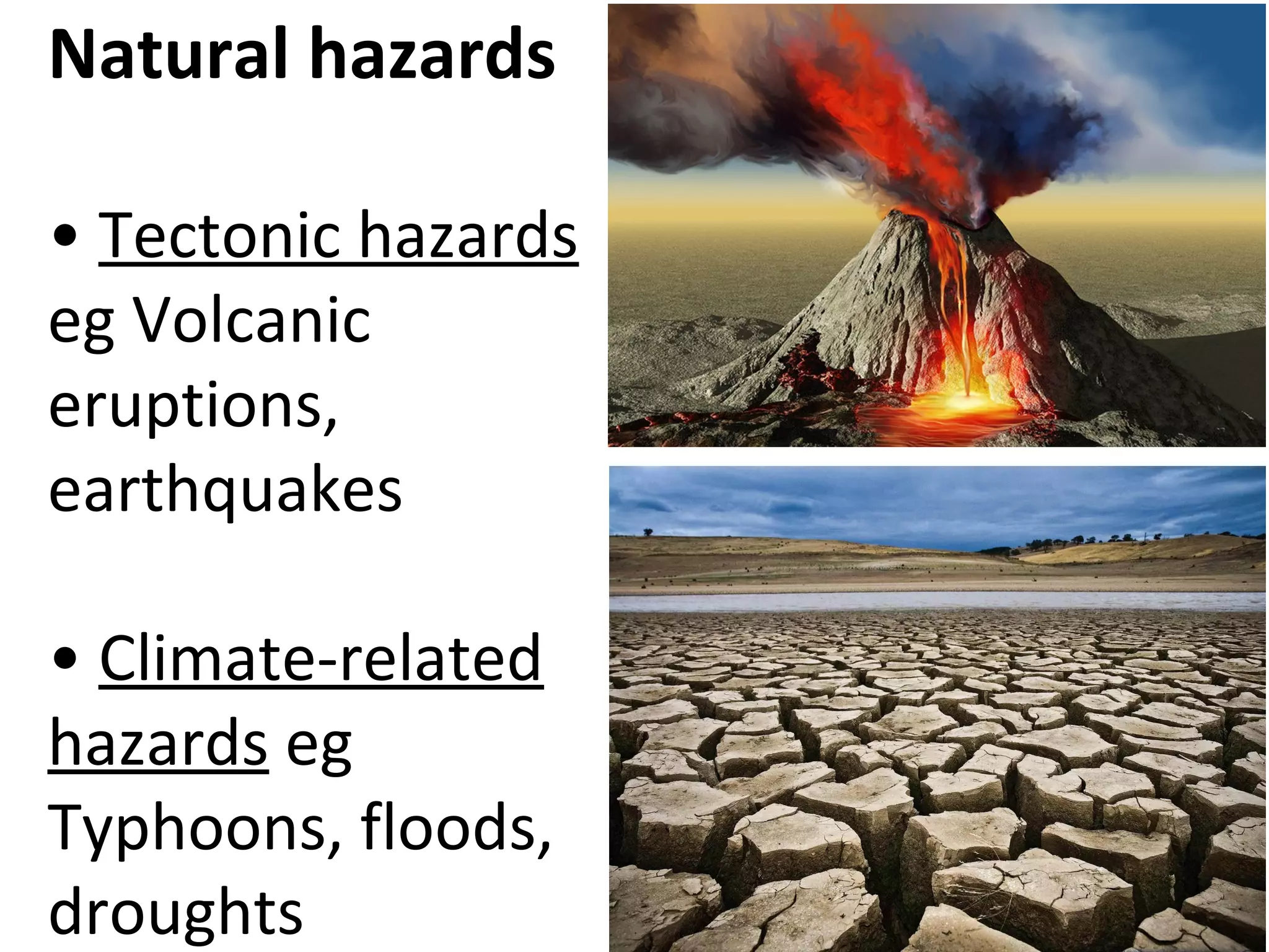
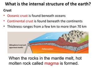
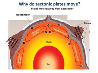
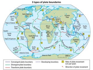
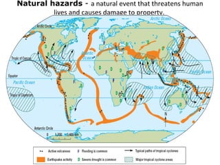
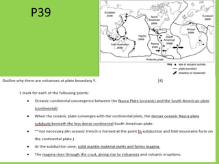
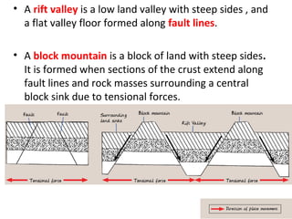
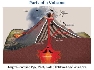
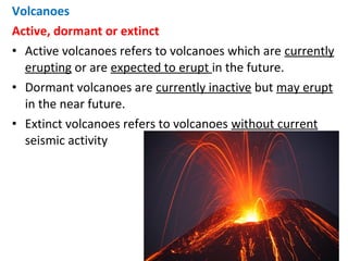
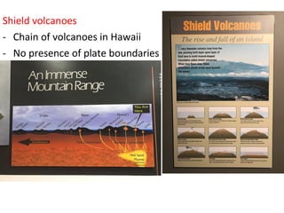
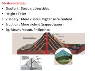
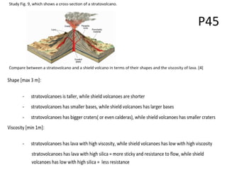
Natural hazards include tectonic hazards like volcanic eruptions and earthquakes, as well as climate-related hazards such as typhoons and floods. The internal structure of Earth includes the crust, mantle, and core. The crust varies in thickness and composition depending on whether it is oceanic crust or continental crust. Oceanic crust is thinner and denser, while continental crust is thicker and less dense. Tectonic plates move due to convection currents in the mantle, with plates separating at mid-ocean ridges and coming together at subduction zones.


![Identify if the age of the rocks at zone A is younger or older
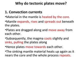
than that found in zone B and explain why this is so. [5]
- Zone A is the youngest and newest rock
- It is nearest to the plate boundary where the
opening of the crust is at.
- Magma rises through the crack and forms new
sea floor at Zone A.
- As the plates move further away from each other
(divergent), Zone B would have the older rocks.
- Eventually the oldest rocks would be found in
Zone C.](https://image.slidesharecdn.com/plates-181119043916/85/Plates-16-320.jpg)
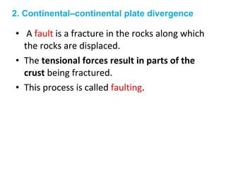
![P37
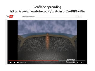
• With reference to Figure 2, describe the tectonic
plate movements and explain why they move. [5]](https://image.slidesharecdn.com/plates-181119043916/85/Plates-17-320.jpg)
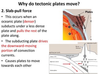
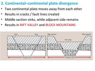
![With reference to Figure 2, describe the tectonic plate
movements and explain why they move. [5]
Describe
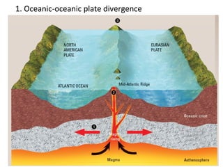
-In Fig, 2, we can see the South America and Nazca plate
moving towards each other at the convergent boundary.
-The Nazca and Pacific plate moving away from each other
at the divergent boundary
Explain
-Plates move due to convection current in the mantle.
-Magma rise and expands from the core, cools and sinks
near the surface. Cycle repeats
-Slab pull force causes plates to drive downwards into the](https://image.slidesharecdn.com/plates-181119043916/85/Plates-18-320.jpg)
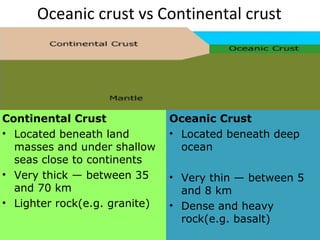
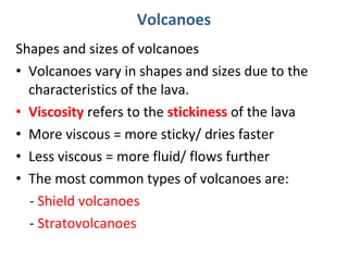
![Homework P118 B
Describe three differences between the oceanic
and continental crust. [3]
- Location : oceanic crust is beneath the deep
ocean, but continental crust is beneath land
masses and under shallow sea.
- Thickness : oceanic crust is very thin (5-8km), but
continental crust is very thick (30 – 60 km)
- Density : oceanic crust is denser (eg basalt) but
continental crust is less dense (eg granite)](https://image.slidesharecdn.com/plates-181119043916/85/Plates-19-320.jpg)
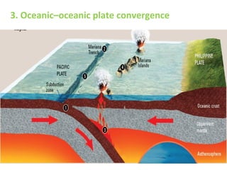
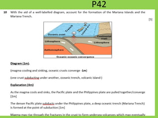
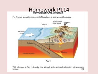
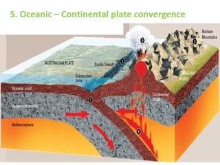
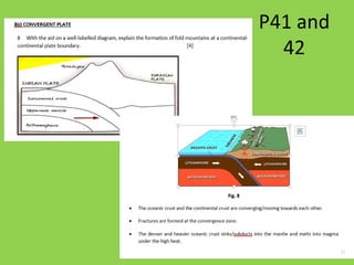
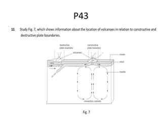
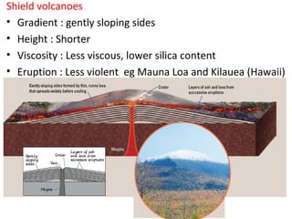
![With reference to Fig 1, describe how a trench and a
series of subduction volcanoes are formed. [4]
Trench
•The two oceanic plates converge and move towards each other. (1m)
•Subduction of the denser oceanic plate occurs whereby the heavier
plate is pushed into the mantle, and a trench is formed at the
subduction zone. (1m)
Subduction volcanoes
•The subducted plate melts into the mantle due to high heat from the
core, and results in excess magma being produced. (1m)
•The magma rises through the openings of the earth’s surface as
volcanoes, a series of subduction volcanoes are formed. (1m)](https://image.slidesharecdn.com/plates-181119043916/85/Plates-51-320.jpg)

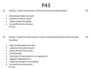
![• Convergent plate boundary: collision of plates
cause subduction (1m) and melting of plates,
this results in excess magma produced and
magma rises through cracks on the Earth’s
crust to form subduction volcanoes (1m)
• Divergent plate boundary: plates moving away
from each other (1m) results in cracks on the
earth’s surface, which causes magma to seep
up from the ground, resulting in formation of
volcanoes (1m)
With the aid of Fig. 1, explain how volcanoes are formed at the plate boundaries.
[4]](https://image.slidesharecdn.com/plates-181119043916/85/Plates-86-320.jpg)

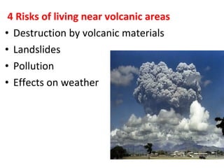
![• ‘There are more risks than benefits of staying
in a volcanic area.’ To what extent do you
agree with this statement?
• Support your answer with examples [6]
P46and P47](https://image.slidesharecdn.com/plates-181119043916/85/Plates-107-320.jpg)
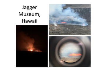
![P=Point Destruction by volcanic materials is a risk that people living in volcanic
areas faced.
D=Describe Volcanic materials include lava and volcanic bombs or rock fragments.
E=Explain People who living in volcanic areas are faced with volcanic eruptions that
produce lava and rock fragments. These volcanic materials can lead to
widespread damage of property. The lava with high temperatures of
between 500° C and 1400° C burns the areas it flows through.
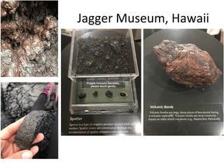
E=Example The ongoing eruption of Kilauea in Hawaii since 1983 has destroyed many
homes and highway.
VOLCANO RISKS AND BENEFITS
Question: The risk of living in volcanic areas outweighs the benefits.” How far do
you agree with this statement? [6]
Using the same format of PDEE, write an answer with 1 set of risk and 1 set of benefit
Introduction:
Risk of living in Volcanic Areas (1 example of risk)
Homework P120](https://image.slidesharecdn.com/plates-181119043916/85/Plates-116-320.jpg)
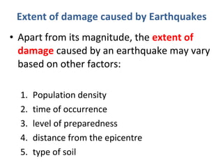
![P49 and P50
• ‘The extent of damages caused by an
earthquake is solely determined by an area’s
proximity to the epicentre.’
• How true is this statement?
• Give reasons and relevant examples in your
answer. [6]](https://image.slidesharecdn.com/plates-181119043916/85/Plates-129-320.jpg)
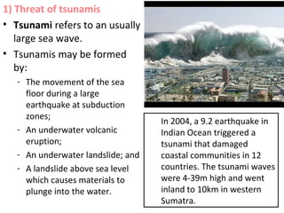
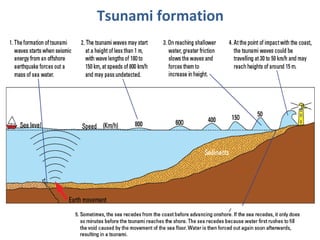
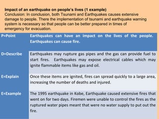
![P=Point Tsunamis can have an impact on the lives of the people.
D=Describe Tsunamis are unusually large waves caused by underwater earthquakes.
E=Explain Tsunamis can travel long distances and caused great destruction to coastal areas
when they sweep inland. At the point of contact on the coast, the tsunami waves
could be travelling at 50km/h and may reach heights of around 15metres.
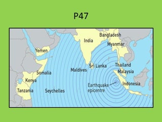
E=Example In 2004, a 9.2 magnitude earthquake occurred in the Indian Ocean and caused a
tsunami with waves that spread throughout the Indian Ocean. The most damage was
experienced in the low-lying coastal areas of western Sumatra, Indonesia. There was
a loss of lives and destruction of properties along this stretch of the coast.
TSUNAMI AND EARTHQUAKE IMPACT
Question:
‘The impact of a tsunami on people’s lives can be more devastating than that of an earthquake.’
How far do you agree with this statement? Give reasons for your answer. [6]
Introduction:
Yes I agree to a large extent as the devastation by a tsunami is very great on the coastal
communities as it catches many unprepared. This essay will discuss the impact of tsunami and
earthquake on the lives of people.
Impact of a tsunami on people’s lives (1 example)
Homework P119](https://image.slidesharecdn.com/plates-181119043916/85/Plates-136-320.jpg)

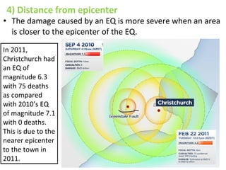
![P48
With reference to Fig. 2, suggest why Christchurch suffered more damage from the 2011
earthquake. [5]
• In 2011, Christchurch is within the first seismic wave which is very near to the epicenter
of the earthquake, while in 2010, Christchurch is at the third seismic wave. In 2011, the
earthquake occurred very near to the surface at a focal depth of 5km so the impact is
greater. Christchurch is a densely built up area with many buildings and the
infrastructure is not built to withstand the stronger vibration felt in 2011. In 2011,
earthquake occurred at 12.51pm where many people are still in offices working when
buildings collapsed, while in 2010 at 4.35am, when most people are not in high-rise
offices. More liquefaction could have occurred in 2011 which makes the infrastructure
unstable.](https://image.slidesharecdn.com/plates-181119043916/85/Plates-144-320.jpg)
![With the help of Fig. 1, explain the impact caused by an earthquake. [3]
- Destruction of properties : structural damage to houses
- Destruction of infrastructure : cracks to form on roads and buildings
- Tsunami : floods and damage coastal communities
Homework P118 A](https://image.slidesharecdn.com/plates-181119043916/85/Plates-147-320.jpg)