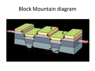
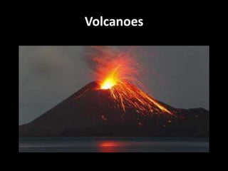
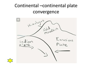
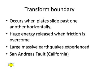
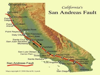
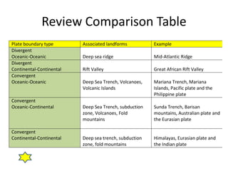
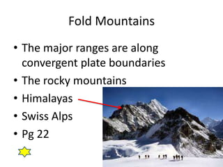
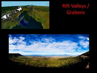
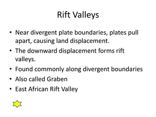
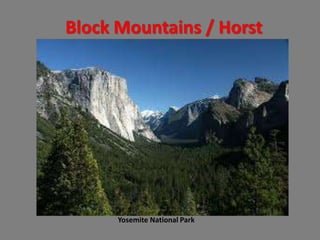
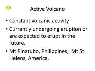
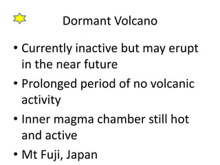
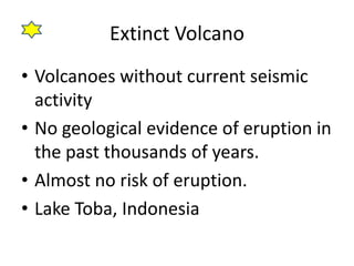
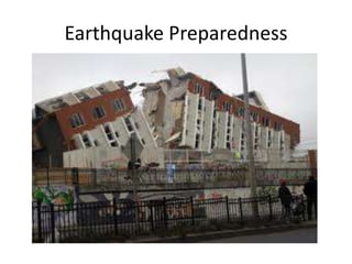
This document provides information about natural hazards caused by tectonic plate movement. It discusses different types of plate boundaries like divergent, convergent and transform boundaries. Key landforms associated with these boundaries are described, such as fold mountains, rift valleys, block mountains, and volcanoes. Specific examples like the Himalayas and Mount Pinatubo are given. The document also explains concepts of tectonic plates, continental drift theory, and the different types of volcanoes.
This is the notes and slides provided and compiled by teachers from reputable schools. Took me many months to compile this and share with you guys! By the way, the slides with a star usually mean that it will be significant so take note! Sharing with you now is this notes!!! Enjoy and love geography!!!
This is the notes and slides provided and compiled by teachers from reputable schools. Sharing with you now is this notes!!! Enjoy and love geography!!!
Executive Directors Chat Leveraging AI for Diversity, Equity, and InclusionTechSoup
Let’s explore the intersection of technology and equity in the final session of our DEI series. Discover how AI tools, like ChatGPT, can be used to support and enhance your nonprofit's DEI initiatives. Participants will gain insights into practical AI applications and get tips for leveraging technology to advance their DEI goals.
How to Add Chatter in the odoo 17 ERP ModuleCeline George
In Odoo, the chatter is like a chat tool that helps you work together on records. You can leave notes and track things, making it easier to talk with your team and partners. Inside chatter, all communication history, activity, and changes will be displayed.
Acetabularia Information For Class 9 .docxvaibhavrinwa19
Acetabularia acetabulum is a single-celled green alga that in its vegetative state is morphologically differentiated into a basal rhizoid and an axially elongated stalk, which bears whorls of branching hairs. The single diploid nucleus resides in the rhizoid.
A Strategic Approach: GenAI in EducationPeter Windle
Artificial Intelligence (AI) technologies such as Generative AI, Image Generators and Large Language Models have had a dramatic impact on teaching, learning and assessment over the past 18 months. The most immediate threat AI posed was to Academic Integrity with Higher Education Institutes (HEIs) focusing their efforts on combating the use of GenAI in assessment. Guidelines were developed for staff and students, policies put in place too. Innovative educators have forged paths in the use of Generative AI for teaching, learning and assessments leading to pockets of transformation springing up across HEIs, often with little or no top-down guidance, support or direction.
This Gasta posits a strategic approach to integrating AI into HEIs to prepare staff, students and the curriculum for an evolving world and workplace. We will highlight the advantages of working with these technologies beyond the realm of teaching, learning and assessment by considering prompt engineering skills, industry impact, curriculum changes, and the need for staff upskilling. In contrast, not engaging strategically with Generative AI poses risks, including falling behind peers, missed opportunities and failing to ensure our graduates remain employable. The rapid evolution of AI technologies necessitates a proactive and strategic approach if we are to remain relevant.
Biological screening of herbal drugs: Introduction and Need for
Phyto-Pharmacological Screening, New Strategies for evaluating
Natural Products, In vitro evaluation techniques for Antioxidants, Antimicrobial and Anticancer drugs. In vivo evaluation techniques
for Anti-inflammatory, Antiulcer, Anticancer, Wound healing, Antidiabetic, Hepatoprotective, Cardio protective, Diuretics and
Antifertility, Toxicity studies as per OECD guidelines
2024.06.01 Introducing a competency framework for languag learning materials ...Sandy Millin
http://sandymillin.wordpress.com/iateflwebinar2024
Published classroom materials form the basis of syllabuses, drive teacher professional development, and have a potentially huge influence on learners, teachers and education systems. All teachers also create their own materials, whether a few sentences on a blackboard, a highly-structured fully-realised online course, or anything in between. Despite this, the knowledge and skills needed to create effective language learning materials are rarely part of teacher training, and are mostly learnt by trial and error.
Knowledge and skills frameworks, generally called competency frameworks, for ELT teachers, trainers and managers have existed for a few years now. However, until I created one for my MA dissertation, there wasn’t one drawing together what we need to know and do to be able to effectively produce language learning materials.
This webinar will introduce you to my framework, highlighting the key competencies I identified from my research. It will also show how anybody involved in language teaching (any language, not just English!), teacher training, managing schools or developing language learning materials can benefit from using the framework.
Read| The latest issue of The Challenger is here! We are thrilled to announce that our school paper has qualified for the NATIONAL SCHOOLS PRESS CONFERENCE (NSPC) 2024. Thank you for your unwavering support and trust. Dive into the stories that made us stand out!
Thinking of getting a dog? Be aware that breeds like Pit Bulls, Rottweilers, and German Shepherds can be loyal and dangerous. Proper training and socialization are crucial to preventing aggressive behaviors. Ensure safety by understanding their needs and always supervising interactions. Stay safe, and enjoy your furry friends!
A review of the growth of the Israel Genealogy Research Association Database Collection for the last 12 months. Our collection is now passed the 3 million mark and still growing. See which archives have contributed the most. See the different types of records we have, and which years have had records added. You can also see what we have for the future.
it describes the bony anatomy including the femoral head , acetabulum, labrum . also discusses the capsule , ligaments . muscle that act on the hip joint and the range of motion are outlined. factors affecting hip joint stability and weight transmission through the joint are summarized.
Delivering Micro-Credentials in Technical and Vocational Education and TrainingAG2 Design
Explore how micro-credentials are transforming Technical and Vocational Education and Training (TVET) with this comprehensive slide deck. Discover what micro-credentials are, their importance in TVET, the advantages they offer, and the insights from industry experts. Additionally, learn about the top software applications available for creating and managing micro-credentials. This presentation also includes valuable resources and a discussion on the future of these specialised certifications.
For more detailed information on delivering micro-credentials in TVET, visit this https://tvettrainer.com/delivering-micro-credentials-in-tvet/
Digital Artefact 1 - Tiny Home Environmental Design
Chapter 1 part 1 2 3 and 4
1. Chapter 1: Living with Tectonic
Hazards
Part 1: Hazards of the world
Copy when you see the star
2. What is a Natural Hazard
• Earthquakes
• Volcano eruption
• Tsunami
3. Earthquake
• Is it possible for Singapore to experience an
earthquake?
• When tremors occur near fault lines, energy is
moved along the crust in waves.
• Such energy when sufficiently strong will
travel long distances.
• Over distance, the energy will reduce.
• If there is a massive earthquake in Indonesia,
we will feel it in Singapore.
4. What the Japanese are trained to do.
• Take a look at the next video.
• Pay attention to the specific action that the
Japanese people do in the event of an
earthquake in the following locations.
– Home
– When driving
– At the shops
• You will have to answer the worksheet after
watching the video so pay attention.
5. Let’s now attempt the exercise
• You have 10 minutes to
answer the questions on the
handout.
• Good luck!
6. What is the structure of the Earth?
•Core
•Mantle
•Crust Read up on Pg 7
in your textbook
7. Tectonic Plate
• The crust of the earth.
• Two general types
–Continental plate
• Less Dense, heavier
–Oceanic plate
• Denser, lighter
8. Continental Drift
• Theory that crustal plates are constantly
moving
• Convectional currents move in the mantle due
to the variations of temperature.
• Warmer magma near the core rises, pushing
the crust above to the sides before sinking
down upon losing the temperature.
10. Evidence of Continental Drift Theory
• The changing shape of earth’s land
mass over earth’s history shows that
the plates are moving.
• The current location of the
continents on earth will continue to
change.
12. SRP Work
• Watch the following video on Colliding
Continents
• Answer the questions in the SRP handout /
complete the groupwork
• http://www.youtube.com/watch?v=KCSJNBM
OjJs
• 50 mins National Geographic video
15. Divergent plates
Oceanic – Oceanic divergence
• Area where two oceanic plates move
away from each other
• Magma moves up to the surface and
cools to form new oceanic crust
• Mid-Atlantic Ridge
• Possible to find underwater
volcanoes at such locations.
17. Continental – Continental divergence
• Area where two continental plates move away
from each other
• Magma moves up to the surface and cools,
forming new land.
• Often fractures form at the plate boundary,
forming a linear depression (rift valley)
• Great African Rift Valley
18. Exercise Time
• What do you think is needed to answer this
question?
– “ With the aid of diagram (s), explain the different
types of divergent plate boundaries that you have
learnt. Give specific examples.”
– Use Foolscap paper, complete your diagrams and
short explanations with examples.
– Diagrams in pencil please.
20. Plate movements
• If there are plate boundaries that are
diverging, at the end of that plate, there
will be convergence.
• 3 common types of convergent
boundaries
– Oceanic vs Oceanic plate
– Oceanic vs Continental plate
– Continental vs Continental plate
21. Reasons for convergence
• Plates converge due to continental drift.
• As the plates are pushed apart, they crash into
one another.
• Generally, the denser plate will subduct (sink)
below the less dense plate.
• The plate that is riding above will buckle (fold)
and massive landforms will occur.
22. Oceanic Crusts
• Beneath deep oceans
• Between 5km and 8km
• Consists of basalt
• Very dense and heavy
• Made of young rock (200 million years ago)
23. Continental Crust
• Beneath the earth’s land masses
• Between 30-60 km
• Consists of lighter rock, like granite
• Wide range of rock ages, from recent to over 4
billion year old.
24. Oceanic-oceanic plate boundaries
• When two oceanic plates converge
• Denser plate subducts under the less dense
plate
• Area where it subducts is called the
subduction zone
• A depression in the sea floor occurs at the
subduction zone and is called a deep sea
trench. (The Mariana Trench)
• Volcanic islands can also be formed at such
boundaries
26. Oceanic-Continental plate convergence
• When an oceanic plate converges with a
continental plate.
• The dense oceanic plate is forced down into
the mantle.
• A deep sea trench is often formed at the
subduction zone. (Japanese deep sea trench)
• The continental plate folds and forms fold
mountains and volcanoes
• The Japanese Islands were a result of such
convergence.
28. Continental-Continental plate convergence
• When two equally dense continental plates
converge.
• There will still be a subduction occurring for
one of the plates. However there is a large
amount of friction built-up before it occurs.
• The strong force generated also causes
folding.
• At such plate boundaries, large mountain
ranges tend to form. (Himalaya)
30. Transform boundary
• Occurs when plates slide past one
another horizontally.
• Huge energy released when friction is
overcome
• Large massive earthquakes experienced
• San Andreas Fault (California)
31.
32.
33. Exercise time
• Take a look at the handout (exercise 2).
• Using the information you have learnt so far,
answer the question to the best of your
abilities.
• Good luck
34. Review Comparison Table
Plate boundary type Associated landforms Example
Divergent
Oceanic-Oceanic Deep sea ridge Mid-Atlantic Ridge
Divergent
Continental-Continental Rift Valley Great African Rift Valley
Convergent
Oceanic-Oceanic Deep Sea Trench, Volcanoes, Mariana Trench, Mariana
Volcanic Islands Islands, Pacific plate and the
Philippine plate
Convergent
Oceanic-Continental Deep Sea Trench, subduction Sunda Trench, Barisan
zone, Volcanoes, Fold mountains, Australian plate and
mountains the Eurasian plate
Convergent
Continental-Continental Deep sea trench, subduction Himalayas, Eurasian plate and
zone, fold mountains the Indian plate
37. Fold Mountains
• The rock layers on the crust are
constantly exposed to pressure
• When they are compressed, they
fold, forming fold mountains.
• To upfold is called the anticline and
downfold is called the syncline.
38. Fold Mountains
• The major ranges are along
convergent plate boundaries
• The rocky mountains
• Himalayas
• Swiss Alps
• Pg 22
40. Rift Valleys
• Near divergent plate boundaries, plates pull
apart, causing land displacement.
• The downward displacement forms rift
valleys.
• Found commonly along divergent boundaries
• Also called Graben
• East African Rift Valley
43. Block Mountains
• When sections of the crust are pulled
apart by tensional force, some parts are
ripped off.
• The downward displaced areas are the
rift valleys
• The blocks left behind form block
mountains with steep sides.
• Also called Horst
46. Volcanoes
• Landform formed by magma ejected from the
mantle.
• Magma builds up in the earth’s crust to form a
magma chamber.
• With repeated layering of ejected magma, the
volcano grows in height
• Found a divergent and convergent plate
boundaries where there is subduction.
47. • Vents are openings in the earth’s surface
with a pipe leading into the magma
chamber
• When magma is ejected onto the
surface, it is called lava. There is no
change in composition.
• Vulcanicity refers to the upward
movement of magma in the crust and
onto the surface.
48.
49. Let’s take a short Brain Break
• Take a look at the
video on Mt St
Helens in America
• Half the volcano
was blown off in the
eruption
50. Viscosity
• The stickiness of the lava
• The resistance of the lava to flowing
• High viscosity flows slowly
• Low viscosity flows quickly
• Viscosity of the lava determines the
volcano’s shape
53. Shield Volcanoes
• Gentle sloping sides and a broad
summit
• Low-silica lava (low viscosity) present
• Lava flow is fast, spreading out
quickly
• Subsequent layering leads to wide
base with low overall height.
• Mount Washington in America
55. Stratovolcano
• Developed from successive eruptions.
• Ash and lava (coarse fragment) accumulate over
time.
• Layers of ash are locked in by subsequent layers of
lava.
• Tall volcanoes with concave bases formed.
• Secondary cones may develop as magma from the
vent seeps into the sides of the cone and erupts.
• Pyroclastic flow common
– Hot rock fragments and superheated gases.
• Mount Pinatubo, Philippines
57. Distribution of volcanoes
• Pacific Ring of Fire is the most active volcanic
activity occurs
• Many earthquakes and volcanic eruptions
occur along the ring of fire
• Ring is along several converging plates (Pacific,
Nazca, Philippines, Australian and Eurasian
plates)
• Volcanoes can also form where plates diverge.
• Pg 29
60. Active Volcano
• Constant volcanic activity
• Currently undergoing eruption or
are expected to erupt in the
future.
• Mt Pinatubo, Philippines; Mt St
Helens, America.
61. Dormant Volcano
• Currently inactive but may erupt
in the near future
• Prolonged period of no volcanic
activity
• Inner magma chamber still hot
and active
• Mt Fuji, Japan
62. Extinct Volcano
• Volcanoes without current seismic
activity
• No geological evidence of eruption in
the past thousands of years.
• Almost no risk of eruption.
• Lake Toba, Indonesia
63. Risks of living near volcanic areas
1.Destruction by volcanic
materials
2.Landslides
3.Pollution
4.Effects on weather
64. Destruction by volcanic materials
• Lava, rock fragments, volcanic bombs (ejected
molten lava blobs)
• Extreme temperatures of projectiles and lava
flow, destroying and killing.
• Inhaling hot gases and ash can also lead to
injury and death.
• With pyroclastic flow, speeds above 80km/hr
can be achieved, making it impossible to
escape.
66. Landslides
• Collapse of a volcanic cone during eruption.
• Downward displacement of previous slide of
volcano.
• Causes large scale damage to infrastructure
and loss of life.
• Settlements near the volcano may get wiped
out totally.
68. Pollution
• Ash particles and gases released disrupt
human activities over long distances.
• Some gases (Carbon monoxide, Sulphur
dioxide, etc) are harmful to humans
• Fine ash particles captured in the air endanger
planes and cause large monetary loss due to
grounding of flights.
70. Effects on weather
• Sulphur dioxide reacts with water vapour in
the atmosphere.
• The particles reflect the sun’s energy back into
space.
• This leads to a cooling of surface temperatures
on earth.
• Fall in global temperature might affect plant
and animal life.
71. Let’s attempt an exercise on what we
have covered.
• 15 - 20 minutes,
• Complete all the questions in
Foolscap / space provided
• Good luck
72. Earthquakes
• Caused by sudden release of stored
energy due to movements of crustal
plates.
• Occurs along faultlines as pressure builds
up stress and when the plates slip,
earthquakes are formed.
73. Key Earthquake Terms
• Seismic waves – energy that is released
by earthquakes.
• Focus – the point in the crustal plate
where the seismic energy originates.
• Epicentre – point above the Focus on
earth’s surface. Most of the energy
released travels along the surface of the
earth.
74. • Aftershocks
– subsequent smaller earthquakes that follow
after a major earthquake.
– Could continue to occur months after the
initial earthquake.
– Some aftershocks might be as powerful as
the original earthquake.
75. Depth of Focus
• The depth of focus affects the
impact felt on the surface.
• 2 key types
1. Deep-focus earthquakes
2. Shallow-focus earthquakes
76. Depth of focus
• Deep-focus earthquake
–70 to 700km below surface
–Smaller impact on land
–Most of seismic waves lose their
energy as they reach the surface.
77. Depth of focus
• Shallow-focus earthquake
–70km and above in the crust
–Greater impact on land
–Seismic waves reach surface
quickly and with more energy.
78. Measurement of earthquakes
• Richter scale (Pg31 in textbook)
9?? Destruction impacts thousands of kilometers of land
79. Factors affecting earthquake damage
• Population Density
• Level of Preparedness
• Distance from epicentre
• Time of occurance
• Soil type
80. Population density
– High population density affects more people
– Tendency for high-rise buildings increases damage
– Higher literacy rate in cities mean higher chance
of better preparedness.
• Higher chance of survival
• Better evacuation plans, trained rescue workers.
81. Level of preparedness
• Proper public training and social
awareness leads to less panic
• Repeated practice of emergency
exercise leads to familiarity of action
• Emergency preparedness kits raise
possibility of survival
83. Distance from the epicentre
• Seismic energy weakens as the
distance increases from the
epicentre.
• Locations further away from the
epicentre suffer less from the
earthquake.
84. Time of occurance
• Time of earthquake determines what
people are doing and whether they are
able to react.
• At night, people are asleep. There is less
time to react.
• In the day, survivors of an earthquake are
able to avoid subsequent accidents.
85. Type of soil
• Loose and unconsolidated (not packed
tightly) soil move more in times of an
earthquake.
• Impact on the buildings on the surface is
greater. Damage is often worse.
• Liquefaction – loose soil flowing like
water.
• Danger of landslides after earthquakes
cause more harm.
86. Earthquake zones
• Tendency for earthquakes to occur
along crustal plate margins.
• Tendency for earthquakes to be
caused when subduction along
destructive plates or slipping of
transform plates
88. Hazards of living in earthquake zones
• Tsunamis
• Disruption of services
• Fire
• Landslides
• Loss of lives
• Loss of property
89. Tsunamis
• Tsunami – an unusually large sea wave
• Formed by sudden movement of sea floor
• Possible causes
– Earthquakes at subduction zones
– Explosive underwater volcano eruption
– Underwater landslide
– Large coastal landslides
90. Tsunamis
• As the displaced water moves, it gathers
strength and size.
• When it hits the coast, large destruction is
resulted.
91. Disruption of services
• Loss of electricity, gas and water leads to
loss of essential services.
• Broken pipelines also raise the risk of
explosions.
• Roads and railway destruction make it
harder to send aid.
92. Fire
• Earthquakes at timings where meals are
prepared raise risk of fires.
• Gas pipes and electric cables that are
broken lead to fire risk.
• Urban areas are densely populated,
hence larger fire risk.
93. Landslides
• Shaking of earthquakes loosen soil.
• Along slopes and hills, original vegetation
may no longer be able to hold soil.
• Landslides and mudflows cause large
damage.
• Heavy rainfall after earthquakes raise the
risk of landslides.
94. Destruction of property and
Loss of lives
• Earthquakes destroy homes and buildings that
are not earthquake proof.
• Large amount of money needs to be spent to
rebuild the property.
• Urban areas with more infrastructure (roads,
subways) cause even more money to repair.
96. 4 key benefits of living near volcanoes
• Fertile soil
• Precious stones and minerals, building
materials
• Tourism
• Geothermal energy
97. Fertile Soil
• Lava and ash breakdown to form fertile
volcanic soils
• The richest soils on earth, highly
favourable for agriculture
• Hawaii and Bali
98.
99.
100. Precious stones and building materials
• Volcanic rocks can be rich in precious stones
and minerals.
• After the top layers of volcanic rocks are
eroded, these can be extracted.
• The volcanic rocks at Kimberley, South Africa,
are the richest source of diamonds globally.
• Other useful materials like sulphur can be
collected from volcanic rocks. Sulphur is used
to refine sugar and make matches and
fertilisers.
101.
102. Tourism
• Volcanic areas have dramatic landscapes.
• Scenery attracts tourists for hiking and
camping.
• Volcanic areas are rich in history and attract
visitors too.
• The ruins of Pompeii, Italy. The black beaches
in Bali
103.
104. Geothermal Energy
• When groundwater comes in contact with the
hot rocks underground, it heats up and
escapes as steam.
• This can be harnessed to produce Geothermal
Energy.
• Large turbines are used to complete this
process.
• Iceland uses Geothermal energy to power
over 70% of their homes.
105.
106. Why do people live in such places?
• Favorable living conditions
–Fertile soil conditions for
agriculture.
• No alternative location to live in.
–Case of no choice
107. Review Question
• Turn to pg 47 of your textbook.
• Using that map, let’s answer the questions in
the handout.
Editor's Notes
Watch video on youtube (news report on Sgp experiencing tremors April 2012) click on lightning to open link.http://www.youtube.com/watch?v=7Eb8xYbF_Po
Video on Japanese emergency action training http://www.youtube.com/watch?v=IaedDlN5dfoWatch once, then at kids request restart at techniques (around 3 min mark) before giving exercise.
Draw Continental Drift Theory Diagram.
http://www.youtube.com/watch?v=ryrXAGY1dmE1m 14 sec vid on continental drift
Draw oceanic divergent plate diagram
Draw diagram of continental –continental divergence
Video on Oceanic vs Continental plate, buckling, forming mountains and Tsunami occuring prior to reset.http://www.youtube.com/watch?v=ep2_axAA9Mw
http://www.youtube.com/watch?v=7LgZThrw9DMWatch from 7.00 to 8.00 to see deformed diagram and misguided truth about Japanese Trench.
Click on picture to show 3 min vid on San Andreas Fault (National Geographic)http://www.youtube.com/watch?v=ZxPTLmg0ZCwWatch also the next clip on the damage to roads to LA after 94 quake click on Agent Phttp://www.youtube.com/watch?v=mcoHJHo8d6kFinal additional clip of a classroom destroyed during a quake http://www.youtube.com/watch?v=FW-TkpvKPl0
Refer to Unit 1 Ex 2 (map of plate boundaries and Qn on possible phenomena at 3 such boundaries).
Click on picture to watch 2 min vid on top 10 active volcanoes in the world
Watch 6min vid on Mt St Helen eruption 1980s.http://www.youtube.com/watch?v=-H_HZVY1tT4
Honey – high viscosityWater – low viscosity
Watch video on Mt Pinatubo eruption Human impacthttp://www.youtube.com/watch?v=NQzGjGKdGvQ (4 min)Or
Watch video on Pacific ring of fire (10 mins)http://www.youtube.com/watch?v=YqSJDNi7Qzw
Watch 2.25 min video footage of the plaster cast people of Pompeihttp://www.youtube.com/watch?v=8P352045O-oHighlight that these people were instantly turned into plaster casts by the pyroclastic flow.
Watch video on the landslide after Mt St Helen’s eruptionhttp://www.youtube.com/watch?v=UK--hvgP2uY2 min vid
Watch FOX news rpt on Iceland volcanic eruption grounding flightshttp://www.youtube.com/watch?v=RCWp1fGP_6M3 minsAlJazeera clip on Heathrow opening and passengers stranded in SGP flying backhttp://www.youtube.com/watch?v=WfcTMlP5UTA
Issue Ex 5 on the negative effects of living near a volcano
Watch view of destruction post earthquake in Christchurch(2min)http://www.youtube.com/watch?v=opsiKirDfdENews report on Christchurch massive quake (response by gvt)(1:30 min)http://www.youtube.com/watch?v=wBq1-qZWmhM
Watch NZ video on Earthquake Preparedness(4min)http://www.youtube.com/watch?v=-a7T9Uf-JB4
Watch clip on tremors in SGP (who is our buffer?) Indonesia!http://www.youtube.com/watch?v=7Eb8xYbF_Po
Watch video of damage of 7.2 Christchurch earthquake 2011. End of vid, ask students to think if it had happened in the middle of the night, what might the death toll be looking at the look of the damage in the video?http://www.youtube.com/watch?v=jlykXk82BlY(3min)
Watch short clip on liquefaction (45 secs)http://www.youtube.com/watch?v=qmVYbjiNWdsAlternate vid (forward to 50s) to watch the video of liquefaction.http://www.youtube.com/watch?v=PwvvYxSZ7PI
Pic on left (vid) that shows 2004 Tsunami at Thailandhttp://www.youtube.com/watch?v=ntIwawAusDEPic on right (vid) of Bandar Aceh (initial earthquake and subsequent tsunami) 7 min. Worth watching!http://www.youtube.com/watch?v=ht_ZpSuJ6A4
Watch 3 min vid on Japanese earthquakehttp://abcnews.go.com/Archives/video/jan-17-1995-earthquake-japan-9421417#nightearthquake #fire #JapanEarthquake #destruction
Video of rice fields in Balihttp://www.youtube.com/watch?v=Z83XgZzEOpY
Watch video on blood diamonds , negative effect of having diamonds in the groundhttp://www.youtube.com/watch?v=0hCl_RXqoZk
Watch video on Geothermal energy productionhttp://www.youtube.com/watch?v=rfUQy86ZMpQ