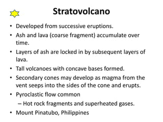
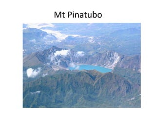
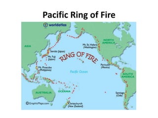
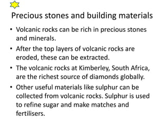
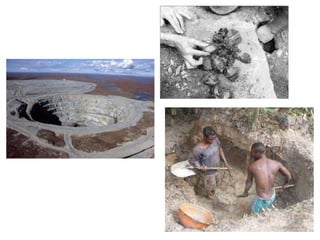
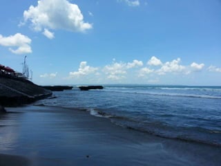
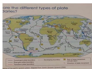
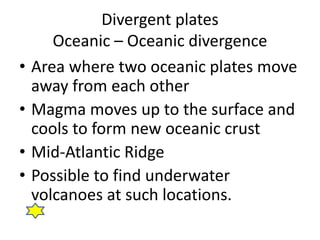
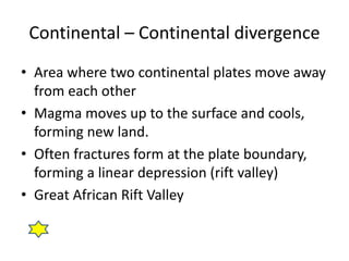
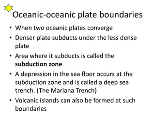
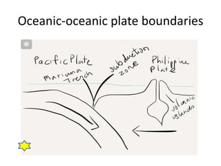
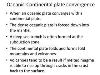
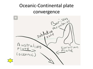
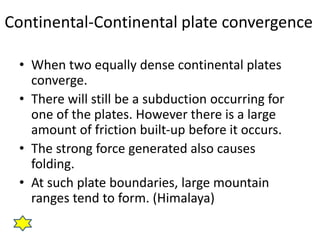
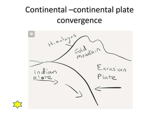
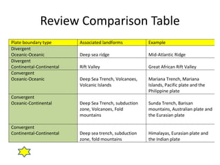
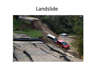
Chapter 1: Living with Tectonic
Hazards
Part 1: Hazards of the world
Copy when you see the star
What is a Natural Hazard
•Earthquakes
•Volcano eruption
•Tsunami
Earthquake
• Is it possible for Singapore to experience an
earthquake?
• When tremors occur near fault lines, energy is
moved along the crust in waves.
• Such energy when sufficiently strong will
travel long distances.
• Over distance, the energy will reduce.
• If there is a massive earthquake in Indonesia,
we will feel it in Singapore.
What the Japanese are trained to do.
• Take a look at the next video.
• Pay attention to the specific action that the
Japanese people do in the event of an
earthquake in the following locations.
– Home
– When driving
– At the shops
• You will have to answer the worksheet after
watching the video so pay attention.
Let’s now attempt the exercise
• You have 10 minutes to
answer the questions on the
handout.
• Good luck!
What is the structure of the Earth?
•Core
•Mantle
•Crust Read up on Pg 7
in your textbook
Tectonic Plate
• The crust of the earth.
• Two general types
–Continental plate
• Less Dense, heavier
–Oceanic plate
• Denser, lighter
Continental Drift
• Theory that crustal plates are constantly
moving
• Convectional currents move in the mantle due
to the variations of temperature.
• Warmer magma near the core rises, pushing
the crust above to the sides before sinking
down upon losing the temperature.
Continental Drift Diagram
Evidence of Continental Drift Theory
• The changing shape of earth’s land
mass over earth’s history shows that
the plates are moving.
• The current location of the
continents on earth will continue to
change.
Continental Drift Diagram
SRP Work
• Watch the following video on Colliding
Continents
• Answer the questions in the SRP handout /
complete the groupwork
• http://www.youtube.com/watch?v=KCSJNBM
OjJs
• 50 mins National Geographic video
Types of plate boundaries
• Convergent plate boundary
• Divergent plate boundary
• Transform plate boundary
• Refer to pg 9 textbook
Divergent plates
Oceanic – Oceanic divergence
• Area where two oceanic plates move
away from each other
• Magma moves up to the surface and
cools to form new oceanic crust
• Mid-Atlantic Ridge
• Possible to find underwater
volcanoes at such locations.
Diagram of Divergent plate boundary
(insert water surface for oceanic)
Continental – Continental divergence
• Area where two continental plates move away
from each other
• Magma moves up to the surface and cools,
forming new land.
• Often fractures form at the plate boundary,
forming a linear depression (rift valley)
• Great African Rift Valley
Exercise Time
• What do you think is needed to answer this
question?
– “ With the aid of diagram (s), explain the different
types of divergent plate boundaries that you have
learnt. Give specific examples.”
– Use Foolscap paper, complete your diagrams and
short explanations with examples.
– Diagrams in pencil please.
Part 2: Convergent plates
Plate movements
• If there are plate boundaries that are
diverging, at the end of that plate, there
will be convergence.
• 3 common types of convergent
boundaries
–Oceanic vs Oceanic plate
–Oceanic vs Continental plate
–Continental vs Continental plate
Reasons for convergence
• Plates converge due to continental drift.
• As the plates are pushed apart, they crash into
one another.
• Generally, the denser plate will subduct (sink)
below the less dense plate.
• The plate that is riding above will buckle (fold)
and massive landforms will occur.
Oceanic Crusts
• Beneath deep oceans
• Between 5km and 8km
• Consists of basalt
• Very dense and heavy
• Made of young rock (200 million years ago)
Continental Crust
• Beneath the earth’s land masses
• Between 30-60 km
• Consists of lighter rock, like granite
• Wide range of rock ages, from recent to over 4
billion year old.
Oceanic-oceanic plate boundaries
• When two oceanic plates converge
• Denser plate subducts under the less dense
plate
• Area where it subducts is called the
subduction zone
• A depression in the sea floor occurs at the
subduction zone and is called a deep sea
trench. (The Mariana Trench)
• Volcanic islands can also be formed at such
boundaries
Oceanic-oceanic plate boundaries
Oceanic-Continental plate convergence
• When an oceanic plate converges with a
continental plate.
• The dense oceanic plate is forced down into
the mantle.
• A deep sea trench is often formed at the
subduction zone.
• The continental plate folds and forms fold
mountains and volcanoes
• Volcanoes tend to be a result if melted magma
is able to rise up through cracks in the crust
back to the surface.
Oceanic-Continental plate
convergence
Continental-Continental plate convergence
• When two equally dense continental plates
converge.
• There will still be a subduction occurring for
one of the plates. However there is a large
amount of friction built-up before it occurs.
• The strong force generated also causes
folding.
• At such plate boundaries, large mountain
ranges tend to form. (Himalaya)
Continental –continental plate
convergence
Transform boundary
• Occurs when plates slide past one
another horizontally.
• Huge energy released when friction is
overcome
• Large massive earthquakes experienced
• San Andreas Fault (California)
Exercise time
• Take a look at the handout (exercise 2).
• Using the information you have learnt so far,
answer the question to the best of your
abilities.
• Good luck
Review Comparison Table
Plate boundary type Associated landforms Example
Divergent
Oceanic-Oceanic Deep sea ridge Mid-Atlantic Ridge
Divergent
Continental-Continental Rift Valley Great African Rift Valley
Convergent
Oceanic-Oceanic Deep Sea Trench, Volcanoes,
Volcanic Islands
Mariana Trench, Mariana
Islands, Pacific plate and the
Philippine plate
Convergent
Oceanic-Continental Deep Sea Trench, subduction
zone, Volcanoes, Fold
mountains
Sunda Trench, Barisan
mountains, Australian plate and
the Eurasian plate
Convergent
Continental-Continental Deep sea trench, subduction
zone, fold mountains
Himalayas, Eurasian plate and
the Indian plate
Part 3
Landforms commonly associated at
tectonic boundaries
Fold Mountains
Fold Mountains
• The rock layers on the crust are
constantly exposed to pressure
• When they are compressed, they
fold, forming fold mountains.
• To upfold is called the anticline and
downfold is called the syncline.
Fold Mountains
• The major ranges are along
convergent plate boundaries
• The rocky mountains
• Himalayas
• Swiss Alps
• Pg 22
Rift Valleys /
Grabens
Rift Valleys
• Near divergent plate boundaries, plates pull
apart, causing land displacement.
• The downward displacement forms rift
valleys.
• Found commonly along divergent boundaries
• Also called Graben
• East African Rift Valley
Rift Valley diagram
Block Mountains / Horst
Yosemite National Park
Block Mountains
• When sections of the crust are pulled
apart by tensional force, some parts are
ripped off.
• The downward displaced areas are the
rift valleys
• The blocks left behind form block
mountains with steep sides.
• Also called Horst
Block Mountain diagram
Volcanoes
Volcanoes
• Landform formed by magma ejected from the
mantle.
• Magma builds up in the earth’s crust to form a
magma chamber.
• With repeated layering of ejected magma, the
volcano grows in height
• Found a divergent and convergent plate
boundaries where there is subduction.
• Vents are openings in the earth’s surface
with a pipe leading into the magma
chamber
• When magma is ejected onto the
surface, it is called lava. There is no
change in composition.
• Vulcanicity refers to the upward
movement of magma in the crust and
onto the surface.
Let’s take a short Brain Break
• Take a look at the
video on Mt St
Helens in America
• Half the volcano
was blown off in the
eruption
Viscosity
• The stickiness of the lava
• The resistance of the lava to flowing
• High viscosity flows slowly
• Low viscosity flows quickly
• Viscosity of the lava determines the
volcano’s shape
2 Key types of Volcanoes
1.Shield Volcanoes
2.Composite Volcanoes
(Stratovolcanoes)
Shield Volcanoes
Shield Volcanoes
• Gentle sloping sides and a broad
summit
• Low-silica lava (low viscosity) present
• Lava flow is fast, spreading out
quickly
• Subsequent layering leads to wide
base with low overall height.
• Mount Washington in America
Stratovolcanoes
Stratovolcano
• Developed from successive eruptions.
• Ash and lava (coarse fragment) accumulate over
time.
• Layers of ash are locked in by subsequent layers of
lava.
• Tall volcanoes with concave bases formed.
• Secondary cones may develop as magma from the
vent seeps into the sides of the cone and erupts.
• Pyroclastic flow common
– Hot rock fragments and superheated gases.
• Mount Pinatubo, Philippines
Mt Pinatubo
Distribution of volcanoes
• Pacific Ring of Fire is the most active volcanic
activity occurs
• Many earthquakes and volcanic eruptions
occur along the ring of fire
• Ring is along several converging plates (Pacific,
Nazca, Philippines, Australian and Eurasian
plates)
• Volcanoes can also form where plates diverge.
• Pg 29
Pacific Ring of Fire
Volcanic Eruptions
• Volcanoes fall into 3 states
–Active
–Dormant
–Extinct
Active Volcano
• Constant volcanic activity
• Currently undergoing eruption or
are expected to erupt in the
future.
• Mt Pinatubo, Philippines; Mt St
Helens, America.
Dormant Volcano
• Currently inactive but may erupt
in the near future
• Prolonged period of no volcanic
activity
• Inner magma chamber still hot
and active
• Mt Fuji, Japan
Extinct Volcano
• Volcanoes without current seismic
activity
• No geological evidence of eruption in
the past thousands of years.
• Almost no risk of eruption.
• Lake Toba, Indonesia
Risks of living near volcanic areas
1.Destruction by volcanic
materials
2.Landslides
3.Pollution
4.Effects on weather
Destruction by volcanic materials
• Lava, rock fragments, volcanic bombs (ejected
molten lava blobs)
• Extreme temperatures of projectiles and lava
flow, destroying and killing.
• Inhaling hot gases and ash can also lead to
injury and death.
• With pyroclastic flow, speeds above 80km/hr
can be achieved, making it impossible to
escape.
The loss people of Pompei
Landslides
• Collapse of a volcanic cone during eruption.
• Downward displacement of previous slide of
volcano.
• Causes large scale damage to infrastructure
and loss of life.
• Settlements near the volcano may get wiped
out totally.
Landslide
Pollution
• Ash particles and gases released disrupt
human activities over long distances.
• Some gases (Carbon monoxide, Sulphur
dioxide, etc) are harmful to humans
• Fine ash particles captured in the air endanger
planes and cause large monetary loss due to
grounding of flights.
Pollution
Effects on weather
• Sulphur dioxide reacts with water vapour in
the atmosphere.
• The particles reflect the sun’s energy back into
space.
• This leads to a cooling of surface temperatures
on earth.
• Fall in global temperature might affect plant
and animal life.
Let’s attempt an exercise on what we
have covered.
• 15 - 20 minutes,
• Complete all the questions in
Foolscap / space provided
• Good luck
Earthquakes
• Caused by sudden release of stored
energy due to movements of crustal
plates.
• Occurs along faultlines as pressure builds
up stress and when the plates slip,
earthquakes are formed.
Key Earthquake Terms
• Seismic waves – energy that is released
by earthquakes.
• Focus – the point in the crustal plate
where the seismic energy originates.
• Epicentre – point above the Focus on
earth’s surface. Most of the energy
released travels along the surface of the
earth.
• Aftershocks
–subsequent smaller earthquakes that follow
after a major earthquake.
–Could continue to occur months after the
initial earthquake.
–Some aftershocks might be as powerful as
the original earthquake.
Depth of Focus
• The depth of focus affects the
impact felt on the surface.
• 2 key types
1. Deep-focus earthquakes
2. Shallow-focus earthquakes
Depth of focus
• Deep-focus earthquake
–70 to 700km below surface
–Smaller impact on land
–Most of seismic waves lose their
energy as they reach the surface.
Depth of focus
• Shallow-focus earthquake
–70km and above in the crust
–Greater impact on land
–Seismic waves reach surface
quickly and with more energy.
Measurement of earthquakes
• Richter scale (Pg31 in textbook)
9?? Destruction impacts thousands of kilometers of land
Factors affecting earthquake damage
• Population Density
• Level of Preparedness
• Distance from epicentre
• Time of occurance
• Soil type
Population density
– High population density affects more people
– Tendency for high-rise buildings increases damage
– Higher literacy rate in cities mean higher chance
of better preparedness.
• Higher chance of survival
• Better evacuation plans, trained rescue workers.
Level of preparedness
• Proper public training and social
awareness leads to less panic
• Repeated practice of emergency
exercise leads to familiarity of action
• Emergency preparedness kits raise
possibility of survival
Earthquake Preparedness
Distance from the epicentre
• Seismic energy weakens as the
distance increases from the
epicentre.
• Locations further away from the
epicentre suffer less from the
earthquake.
Time of occurance
• Time of earthquake determines what
people are doing and whether they are
able to react.
• At night, people are asleep. There is less
time to react.
• In the day, survivors of an earthquake are
able to avoid subsequent accidents.
Type of soil
• Loose and unconsolidated (not packed
tightly) soil move more in times of an
earthquake.
• Impact on the buildings on the surface is
greater. Damage is often worse.
• Liquefaction – loose soil flowing like
water.
• Danger of landslides after earthquakes
cause more harm.
Earthquake zones
• Tendency for earthquakes to occur
along crustal plate margins.
• Tendency for earthquakes to be
caused when subduction along
destructive plates or slipping of
transform plates
Earthquake Zones
Hazards of living in earthquake zones
• Tsunamis
• Disruption of services
• Fire
• Landslides
• Loss of lives
• Loss of property
Tsunamis
• Tsunami – an unusually large sea wave
• Formed by sudden movement of sea floor
• Possible causes
– Earthquakes at subduction zones
– Explosive underwater volcano eruption
– Underwater landslide
– Large coastal landslides
Tsunamis
• As the displaced water moves, it gathers
strength and size.
• When it hits the coast, large destruction is
resulted.
Disruption of services
• Loss of electricity, gas and water leads to
loss of essential services.
• Broken pipelines also raise the risk of
explosions.
• Roads and railway destruction make it
harder to send aid.
Fire
• Earthquakes at timings where meals are
prepared raise risk of fires.
• Gas pipes and electric cables that are
broken lead to fire risk.
• Urban areas are densely populated,
hence larger fire risk.
Landslides
• Shaking of earthquakes loosen soil.
• Along slopes and hills, original vegetation
may no longer be able to hold soil.
• Landslides and mudflows cause large
damage.
• Heavy rainfall after earthquakes raise the
risk of landslides.
Destruction of property and
Loss of lives
• Earthquakes destroy homes and buildings that
are not earthquake proof.
• Large amount of money needs to be spent to
rebuild the property.
• Urban areas with more infrastructure (roads,
subways) cause even more money to repair.
Part 4
Benefits of living near a Volcano
4 key benefits of living near volcanoes
• Fertile soil
• Precious stones and minerals, building
materials
• Tourism
• Geothermal energy
Fertile Soil
• Lava and ash breakdown to form fertile
volcanic soils
• The richest soils on earth, highly
favourable for agriculture
• Hawaii and Bali
Precious stones and building materials
• Volcanic rocks can be rich in precious stones
and minerals.
• After the top layers of volcanic rocks are
eroded, these can be extracted.
• The volcanic rocks at Kimberley, South Africa,
are the richest source of diamonds globally.
• Other useful materials like sulphur can be
collected from volcanic rocks. Sulphur is used
to refine sugar and make matches and
fertilisers.
Tourism
• Volcanic areas have dramatic landscapes.
• Scenery attracts tourists for hiking and
camping.
• Volcanic areas are rich in history and attract
visitors too.
• The ruins of Pompeii, Italy. The black beaches
in Bali
Geothermal Energy
• When groundwater comes in contact with the
hot rocks underground, it heats up and
escapes as steam.
• This can be harnessed to produce Geothermal
Energy.
• Large turbines are used to complete this
process.
• Iceland uses Geothermal energy to power
over 70% of their homes.
Part 5 : Responses to
Earthquakes
‘O’ Level only
Why do people live in such places?
• Favorable living conditions
–Fertile soil conditions for
agriculture.
• No alternative location to live in.
–Case of no choice
Review Question
• Turn to pg 47 of your textbook.
• Using that map, let’s answer the questions in
the handout.
3 approaches to earthquakes
1.Fatalistic approach
2.Acceptance approach
3.Adaptation approach
Fatalistic approach
• People who accept earthquakes as
unavoidable.
• Tend to resist evacuation in the face of an
earthquake.
• Common for communities in less
developed countries with limited access
to other places.
• People who live near Mt Pinatubo.
Acceptance approach
• People who accept the risk of living in
earthquake-prone areas due to the
benefits of living in that area.
• Benefit outweigh the costs of moving
away.
• Mostly accepted by the developed
countries.
• People of Christchurch.
Adaptation approach
• People who successfully live in
earthquake-prone areas as they are well
prepared.
• Use of earthquake monitoring devices,
risk assessment, technology to increase
earthquake resistance.
• Costly approach but able to save many
lives and property.
• People in Taiwan and Japan.
Responding to earthquakes

Sec 3 Elective Geog Unit 1 Tectonics

  • 1.
    Chapter 1: Livingwith Tectonic Hazards Part 1: Hazards of the world Copy when you see the star
  • 2.
    What is aNatural Hazard •Earthquakes •Volcano eruption •Tsunami
  • 3.
    Earthquake • Is itpossible for Singapore to experience an earthquake? • When tremors occur near fault lines, energy is moved along the crust in waves. • Such energy when sufficiently strong will travel long distances. • Over distance, the energy will reduce. • If there is a massive earthquake in Indonesia, we will feel it in Singapore.
  • 4.
    What the Japaneseare trained to do. • Take a look at the next video. • Pay attention to the specific action that the Japanese people do in the event of an earthquake in the following locations. – Home – When driving – At the shops • You will have to answer the worksheet after watching the video so pay attention.
  • 5.
    Let’s now attemptthe exercise • You have 10 minutes to answer the questions on the handout. • Good luck!
  • 6.
    What is thestructure of the Earth? •Core •Mantle •Crust Read up on Pg 7 in your textbook
  • 7.
    Tectonic Plate • Thecrust of the earth. • Two general types –Continental plate • Less Dense, heavier –Oceanic plate • Denser, lighter
  • 8.
    Continental Drift • Theorythat crustal plates are constantly moving • Convectional currents move in the mantle due to the variations of temperature. • Warmer magma near the core rises, pushing the crust above to the sides before sinking down upon losing the temperature.
  • 9.
  • 10.
    Evidence of ContinentalDrift Theory • The changing shape of earth’s land mass over earth’s history shows that the plates are moving. • The current location of the continents on earth will continue to change.
  • 11.
  • 12.
    SRP Work • Watchthe following video on Colliding Continents • Answer the questions in the SRP handout / complete the groupwork • http://www.youtube.com/watch?v=KCSJNBM OjJs • 50 mins National Geographic video
  • 13.
    Types of plateboundaries • Convergent plate boundary • Divergent plate boundary • Transform plate boundary • Refer to pg 9 textbook
  • 15.
    Divergent plates Oceanic –Oceanic divergence • Area where two oceanic plates move away from each other • Magma moves up to the surface and cools to form new oceanic crust • Mid-Atlantic Ridge • Possible to find underwater volcanoes at such locations.
  • 16.
    Diagram of Divergentplate boundary (insert water surface for oceanic)
  • 17.
    Continental – Continentaldivergence • Area where two continental plates move away from each other • Magma moves up to the surface and cools, forming new land. • Often fractures form at the plate boundary, forming a linear depression (rift valley) • Great African Rift Valley
  • 18.
    Exercise Time • Whatdo you think is needed to answer this question? – “ With the aid of diagram (s), explain the different types of divergent plate boundaries that you have learnt. Give specific examples.” – Use Foolscap paper, complete your diagrams and short explanations with examples. – Diagrams in pencil please.
  • 19.
  • 20.
    Plate movements • Ifthere are plate boundaries that are diverging, at the end of that plate, there will be convergence. • 3 common types of convergent boundaries –Oceanic vs Oceanic plate –Oceanic vs Continental plate –Continental vs Continental plate
  • 21.
    Reasons for convergence •Plates converge due to continental drift. • As the plates are pushed apart, they crash into one another. • Generally, the denser plate will subduct (sink) below the less dense plate. • The plate that is riding above will buckle (fold) and massive landforms will occur.
  • 22.
    Oceanic Crusts • Beneathdeep oceans • Between 5km and 8km • Consists of basalt • Very dense and heavy • Made of young rock (200 million years ago)
  • 23.
    Continental Crust • Beneaththe earth’s land masses • Between 30-60 km • Consists of lighter rock, like granite • Wide range of rock ages, from recent to over 4 billion year old.
  • 24.
    Oceanic-oceanic plate boundaries •When two oceanic plates converge • Denser plate subducts under the less dense plate • Area where it subducts is called the subduction zone • A depression in the sea floor occurs at the subduction zone and is called a deep sea trench. (The Mariana Trench) • Volcanic islands can also be formed at such boundaries
  • 25.
  • 26.
    Oceanic-Continental plate convergence •When an oceanic plate converges with a continental plate. • The dense oceanic plate is forced down into the mantle. • A deep sea trench is often formed at the subduction zone. • The continental plate folds and forms fold mountains and volcanoes • Volcanoes tend to be a result if melted magma is able to rise up through cracks in the crust back to the surface.
  • 27.
  • 28.
    Continental-Continental plate convergence •When two equally dense continental plates converge. • There will still be a subduction occurring for one of the plates. However there is a large amount of friction built-up before it occurs. • The strong force generated also causes folding. • At such plate boundaries, large mountain ranges tend to form. (Himalaya)
  • 29.
  • 30.
    Transform boundary • Occurswhen plates slide past one another horizontally. • Huge energy released when friction is overcome • Large massive earthquakes experienced • San Andreas Fault (California)
  • 33.
    Exercise time • Takea look at the handout (exercise 2). • Using the information you have learnt so far, answer the question to the best of your abilities. • Good luck
  • 34.
    Review Comparison Table Plateboundary type Associated landforms Example Divergent Oceanic-Oceanic Deep sea ridge Mid-Atlantic Ridge Divergent Continental-Continental Rift Valley Great African Rift Valley Convergent Oceanic-Oceanic Deep Sea Trench, Volcanoes, Volcanic Islands Mariana Trench, Mariana Islands, Pacific plate and the Philippine plate Convergent Oceanic-Continental Deep Sea Trench, subduction zone, Volcanoes, Fold mountains Sunda Trench, Barisan mountains, Australian plate and the Eurasian plate Convergent Continental-Continental Deep sea trench, subduction zone, fold mountains Himalayas, Eurasian plate and the Indian plate
  • 35.
    Part 3 Landforms commonlyassociated at tectonic boundaries
  • 36.
  • 37.
    Fold Mountains • Therock layers on the crust are constantly exposed to pressure • When they are compressed, they fold, forming fold mountains. • To upfold is called the anticline and downfold is called the syncline.
  • 38.
    Fold Mountains • Themajor ranges are along convergent plate boundaries • The rocky mountains • Himalayas • Swiss Alps • Pg 22
  • 39.
  • 40.
    Rift Valleys • Neardivergent plate boundaries, plates pull apart, causing land displacement. • The downward displacement forms rift valleys. • Found commonly along divergent boundaries • Also called Graben • East African Rift Valley
  • 41.
  • 42.
    Block Mountains /Horst Yosemite National Park
  • 43.
    Block Mountains • Whensections of the crust are pulled apart by tensional force, some parts are ripped off. • The downward displaced areas are the rift valleys • The blocks left behind form block mountains with steep sides. • Also called Horst
  • 44.
  • 45.
  • 46.
    Volcanoes • Landform formedby magma ejected from the mantle. • Magma builds up in the earth’s crust to form a magma chamber. • With repeated layering of ejected magma, the volcano grows in height • Found a divergent and convergent plate boundaries where there is subduction.
  • 47.
    • Vents areopenings in the earth’s surface with a pipe leading into the magma chamber • When magma is ejected onto the surface, it is called lava. There is no change in composition. • Vulcanicity refers to the upward movement of magma in the crust and onto the surface.
  • 49.
    Let’s take ashort Brain Break • Take a look at the video on Mt St Helens in America • Half the volcano was blown off in the eruption
  • 50.
    Viscosity • The stickinessof the lava • The resistance of the lava to flowing • High viscosity flows slowly • Low viscosity flows quickly • Viscosity of the lava determines the volcano’s shape
  • 51.
    2 Key typesof Volcanoes 1.Shield Volcanoes 2.Composite Volcanoes (Stratovolcanoes)
  • 52.
  • 53.
    Shield Volcanoes • Gentlesloping sides and a broad summit • Low-silica lava (low viscosity) present • Lava flow is fast, spreading out quickly • Subsequent layering leads to wide base with low overall height. • Mount Washington in America
  • 54.
  • 55.
    Stratovolcano • Developed fromsuccessive eruptions. • Ash and lava (coarse fragment) accumulate over time. • Layers of ash are locked in by subsequent layers of lava. • Tall volcanoes with concave bases formed. • Secondary cones may develop as magma from the vent seeps into the sides of the cone and erupts. • Pyroclastic flow common – Hot rock fragments and superheated gases. • Mount Pinatubo, Philippines
  • 56.
  • 57.
    Distribution of volcanoes •Pacific Ring of Fire is the most active volcanic activity occurs • Many earthquakes and volcanic eruptions occur along the ring of fire • Ring is along several converging plates (Pacific, Nazca, Philippines, Australian and Eurasian plates) • Volcanoes can also form where plates diverge. • Pg 29
  • 58.
  • 59.
    Volcanic Eruptions • Volcanoesfall into 3 states –Active –Dormant –Extinct
  • 60.
    Active Volcano • Constantvolcanic activity • Currently undergoing eruption or are expected to erupt in the future. • Mt Pinatubo, Philippines; Mt St Helens, America.
  • 61.
    Dormant Volcano • Currentlyinactive but may erupt in the near future • Prolonged period of no volcanic activity • Inner magma chamber still hot and active • Mt Fuji, Japan
  • 62.
    Extinct Volcano • Volcanoeswithout current seismic activity • No geological evidence of eruption in the past thousands of years. • Almost no risk of eruption. • Lake Toba, Indonesia
  • 63.
    Risks of livingnear volcanic areas 1.Destruction by volcanic materials 2.Landslides 3.Pollution 4.Effects on weather
  • 64.
    Destruction by volcanicmaterials • Lava, rock fragments, volcanic bombs (ejected molten lava blobs) • Extreme temperatures of projectiles and lava flow, destroying and killing. • Inhaling hot gases and ash can also lead to injury and death. • With pyroclastic flow, speeds above 80km/hr can be achieved, making it impossible to escape.
  • 65.
    The loss peopleof Pompei
  • 66.
    Landslides • Collapse ofa volcanic cone during eruption. • Downward displacement of previous slide of volcano. • Causes large scale damage to infrastructure and loss of life. • Settlements near the volcano may get wiped out totally.
  • 67.
  • 68.
    Pollution • Ash particlesand gases released disrupt human activities over long distances. • Some gases (Carbon monoxide, Sulphur dioxide, etc) are harmful to humans • Fine ash particles captured in the air endanger planes and cause large monetary loss due to grounding of flights.
  • 69.
  • 70.
    Effects on weather •Sulphur dioxide reacts with water vapour in the atmosphere. • The particles reflect the sun’s energy back into space. • This leads to a cooling of surface temperatures on earth. • Fall in global temperature might affect plant and animal life.
  • 71.
    Let’s attempt anexercise on what we have covered. • 15 - 20 minutes, • Complete all the questions in Foolscap / space provided • Good luck
  • 72.
    Earthquakes • Caused bysudden release of stored energy due to movements of crustal plates. • Occurs along faultlines as pressure builds up stress and when the plates slip, earthquakes are formed.
  • 73.
    Key Earthquake Terms •Seismic waves – energy that is released by earthquakes. • Focus – the point in the crustal plate where the seismic energy originates. • Epicentre – point above the Focus on earth’s surface. Most of the energy released travels along the surface of the earth.
  • 74.
    • Aftershocks –subsequent smallerearthquakes that follow after a major earthquake. –Could continue to occur months after the initial earthquake. –Some aftershocks might be as powerful as the original earthquake.
  • 75.
    Depth of Focus •The depth of focus affects the impact felt on the surface. • 2 key types 1. Deep-focus earthquakes 2. Shallow-focus earthquakes
  • 76.
    Depth of focus •Deep-focus earthquake –70 to 700km below surface –Smaller impact on land –Most of seismic waves lose their energy as they reach the surface.
  • 77.
    Depth of focus •Shallow-focus earthquake –70km and above in the crust –Greater impact on land –Seismic waves reach surface quickly and with more energy.
  • 78.
    Measurement of earthquakes •Richter scale (Pg31 in textbook) 9?? Destruction impacts thousands of kilometers of land
  • 79.
    Factors affecting earthquakedamage • Population Density • Level of Preparedness • Distance from epicentre • Time of occurance • Soil type
  • 80.
    Population density – Highpopulation density affects more people – Tendency for high-rise buildings increases damage – Higher literacy rate in cities mean higher chance of better preparedness. • Higher chance of survival • Better evacuation plans, trained rescue workers.
  • 81.
    Level of preparedness •Proper public training and social awareness leads to less panic • Repeated practice of emergency exercise leads to familiarity of action • Emergency preparedness kits raise possibility of survival
  • 82.
  • 83.
    Distance from theepicentre • Seismic energy weakens as the distance increases from the epicentre. • Locations further away from the epicentre suffer less from the earthquake.
  • 84.
    Time of occurance •Time of earthquake determines what people are doing and whether they are able to react. • At night, people are asleep. There is less time to react. • In the day, survivors of an earthquake are able to avoid subsequent accidents.
  • 85.
    Type of soil •Loose and unconsolidated (not packed tightly) soil move more in times of an earthquake. • Impact on the buildings on the surface is greater. Damage is often worse. • Liquefaction – loose soil flowing like water. • Danger of landslides after earthquakes cause more harm.
  • 86.
    Earthquake zones • Tendencyfor earthquakes to occur along crustal plate margins. • Tendency for earthquakes to be caused when subduction along destructive plates or slipping of transform plates
  • 87.
  • 88.
    Hazards of livingin earthquake zones • Tsunamis • Disruption of services • Fire • Landslides • Loss of lives • Loss of property
  • 89.
    Tsunamis • Tsunami –an unusually large sea wave • Formed by sudden movement of sea floor • Possible causes – Earthquakes at subduction zones – Explosive underwater volcano eruption – Underwater landslide – Large coastal landslides
  • 90.
    Tsunamis • As thedisplaced water moves, it gathers strength and size. • When it hits the coast, large destruction is resulted.
  • 91.
    Disruption of services •Loss of electricity, gas and water leads to loss of essential services. • Broken pipelines also raise the risk of explosions. • Roads and railway destruction make it harder to send aid.
  • 92.
    Fire • Earthquakes attimings where meals are prepared raise risk of fires. • Gas pipes and electric cables that are broken lead to fire risk. • Urban areas are densely populated, hence larger fire risk.
  • 93.
    Landslides • Shaking ofearthquakes loosen soil. • Along slopes and hills, original vegetation may no longer be able to hold soil. • Landslides and mudflows cause large damage. • Heavy rainfall after earthquakes raise the risk of landslides.
  • 94.
    Destruction of propertyand Loss of lives • Earthquakes destroy homes and buildings that are not earthquake proof. • Large amount of money needs to be spent to rebuild the property. • Urban areas with more infrastructure (roads, subways) cause even more money to repair.
  • 95.
    Part 4 Benefits ofliving near a Volcano
  • 96.
    4 key benefitsof living near volcanoes • Fertile soil • Precious stones and minerals, building materials • Tourism • Geothermal energy
  • 97.
    Fertile Soil • Lavaand ash breakdown to form fertile volcanic soils • The richest soils on earth, highly favourable for agriculture • Hawaii and Bali
  • 100.
    Precious stones andbuilding materials • Volcanic rocks can be rich in precious stones and minerals. • After the top layers of volcanic rocks are eroded, these can be extracted. • The volcanic rocks at Kimberley, South Africa, are the richest source of diamonds globally. • Other useful materials like sulphur can be collected from volcanic rocks. Sulphur is used to refine sugar and make matches and fertilisers.
  • 102.
    Tourism • Volcanic areashave dramatic landscapes. • Scenery attracts tourists for hiking and camping. • Volcanic areas are rich in history and attract visitors too. • The ruins of Pompeii, Italy. The black beaches in Bali
  • 104.
    Geothermal Energy • Whengroundwater comes in contact with the hot rocks underground, it heats up and escapes as steam. • This can be harnessed to produce Geothermal Energy. • Large turbines are used to complete this process. • Iceland uses Geothermal energy to power over 70% of their homes.
  • 106.
    Part 5 :Responses to Earthquakes ‘O’ Level only
  • 107.
    Why do peoplelive in such places? • Favorable living conditions –Fertile soil conditions for agriculture. • No alternative location to live in. –Case of no choice
  • 108.
    Review Question • Turnto pg 47 of your textbook. • Using that map, let’s answer the questions in the handout.
  • 109.
    3 approaches toearthquakes 1.Fatalistic approach 2.Acceptance approach 3.Adaptation approach
  • 110.
    Fatalistic approach • Peoplewho accept earthquakes as unavoidable. • Tend to resist evacuation in the face of an earthquake. • Common for communities in less developed countries with limited access to other places. • People who live near Mt Pinatubo.
  • 111.
    Acceptance approach • Peoplewho accept the risk of living in earthquake-prone areas due to the benefits of living in that area. • Benefit outweigh the costs of moving away. • Mostly accepted by the developed countries. • People of Christchurch.
  • 112.
    Adaptation approach • Peoplewho successfully live in earthquake-prone areas as they are well prepared. • Use of earthquake monitoring devices, risk assessment, technology to increase earthquake resistance. • Costly approach but able to save many lives and property. • People in Taiwan and Japan.
  • 113.