SlideShare a Scribd company logo
8 Physical Regions of Canada

Mount Logan--

Δ

Mount Logan

Blue

Great Lakes-St. Lawrence Lowlands

Orange

Appalachians

Red

Canadian Shield

Yellow

Interior Plains

Pink

Western Cordillera

Green

Intermountain Range

Brown

Coastal Plains

Purple

Arctic
Appalachian Region
Topography:
• Gentle rolling mountain ranges
• Fertile plateaus and river valleys
• Contains many 3 000 000 000 year old mountains
• Coal, oil and gas can be found in the sedimentary rocks
Climate:
• Maritime climate
• Warmer in the south
•
•

A high temperature from St. John's is 15°C in July
A high precipitation from St. John's is 162 mm in December

A low temperature from St. John's is -5°C in February
• A Low precipitation from St. John's is 78 mm in July
Vegetation:
• Originally heavily forested
• Trees were mixed coniferous and deciduous trees
• These survived on both the mountains and on the plateaus and in
the valleys
Economic Activity:
• Mining
• Agriculture
• Fishing
• Logging
• Urban economic activity
Environmental Concerns:
• Over fishing
• Over development
• Destruction of forest
• Pollution
•
Coastal Plains
Topography:
Lowlands
Has a lot of swamps and marshes
Fairly flat
Climate:
• Maritime climate
• Colder north warmer south
•
•

A high temperature from New Jersey is 20°C in July
A high precipitation from New Jersey is 101 mm in August

A low temperature from New Jersey is 0°C in February
• Average low precipitation of 62 mm in June in New Jersey
Vegetation:
• Some areas were originally pine forest
• Quite lush
• Some areas are covered in jungle
Economic Activity:
• Agriculture
• Fishing
• Urban economic activity
Environmental Concerns
• Over fishing
• Over development
• Rising water levels
• Pollution
•
The Great Lakes-St. Lawrence Lowlands
Topography:
• The Great Lakes section is flat plains broken by gentle rolling hills
• The St. Lawrence section is gently rising flat plains
• Contains several escarpments
Climate:
• Continental climate
•
•

A high temperature from Toronto is 20°C in July
A high precipitation from Toronto is 78 mm in July

A low temperature from Toronto is -5°C in February
• A low precipitation from Toronto is 55 mm in February
• Humid
Vegetation:
• Originally heavily treed
• Had the largest broad leaf forests in Canada
• Main trees were maple, beech, hickory and black walnut
Economic Activity:
• Farming
• Logging
• Manufacturing
• Urban economic activity
Environmental Concerns:
• Ground pollution
• Destruction of forest
• Over development
• Pollution
•
The Interior Plains
Topography:
• Divided into three different elevations separated by escarpments
• Gentle rolling plains
• Very flat
• Becomes a tundra as you progress north
Climate:
• Continental climate
•
•

A high temperature from Regina is 20°C in July
A high precipitation from Regina is 80 mm in June

A low temperature from Regina is -18°C in January
• A low precipitation from Regina is 15 mm in December
• Northern portion has an Arctic climate
Vegetation:
• Originally had prairie grass as tall as a man
• Originally trees grew in river valleys
• Northern portions had boreal forest and became a tundra as it grew
nearer to the Arctic Ocean
• Wheat and other grains are frequently grown
Economic Activity:
• Farming (wheat and grains usually)
• Mining
• Urban economic activity
Environmental Concerns:
• Over development
• Ground pollution
• Pollution
•
The Canadian Shield
Topography:
• Has a higher elevation in the south then in the north
• Has a higher elevation on the outer portions then in the centre
• Areas around Hudson Bay and James Bay are lowlands
• Has a lot of rivers, lakes, swamps and muskeg
Climate:
• Mixed continental and maritime climate
• Varies over the vast area covered by the Canadian Shield
• More and more arctic as you progress north
•
•

A high temperature from Thunder Bay is 15°C in July
A high precipitation from Thunder Bay is 60 mm in August in

A low temperature from Thunder Bay is -20°C in February
• A low precipitation from Thunder Bay is 25 mm in February in
Thunder Bay
Vegetation:
• Mostly boreal forest
• Common trees are spruce, pine and fir
• There also are some deciduous trees such as poplar and white birch
•

North of the tree line there are no trees since they can’t take root
with the permafrost
Economic Activity:
• Pulp and paper industry
• Mining
• Urban economic activity
Environmental Concerns
• Destruction of forests
• Ground pollution
• Over exploitation
• Pollution
•
The Western Cordillera
Topography:
• Ranges of tall, jagged mountains
• Younger mountains then the Appalachians
• The Rocky Mountains form the continental divide
• All water east of the divide flows into the Gulf of Mexico, Arctic
Ocean, Hudson Bay and James Bay
• All water west of the divide flows into the Pacific Ocean
Climate:
• Maritime climate
• Varies greatly from north to south and east to west
•
•

A high temperature from Vancouver is 20°C in July
A high precipitation from Vancouver is 175 mm in December

A low temperature from Vancouver is 0°C in February
• A low precipitation from Vancouver is 25 mm in July
Vegetation:
• Varies greatly on each slope of the mountain
• On the west side trees such as Douglas Fir, western hemlock and
eastern cedar thrive
• On the eastern side grasses and cactuses thrive in the dry climate
Economic Activity
• Logging
• Fishing
• Urban economic activity
Environmental Concerns:
• Over fishing
• Destruction of forest
• Pollution
•
The Intermountain Range
Topography:
• On the other side of the Western Cordillera
• Many of the rivers in this area never reach the sea but end in
brackish lakes or desert sinks while some do make it
• Can be very desert like in some areas
• Other areas are deserts
Climate:
• Very dry as it is in the Western Cordilleras rain shadow
•
•

A high temperature from Prince George is 15°C
A high precipitation Prince George is 75 mm

A low temperature Prince George is -10°C
• A low precipitation Prince George is 27 mm
Vegetation:
• Sparse grass and plants that can survive semi to desert conditions
• Higher elevations are covered in thin pine forest
Economic Activity:
• Ranching
• Mining
• Farming
• Urban economic activity
Environmental Concerns:
• Ground pollution
• Pollution
• Over exploitation
•
The Arctic
Topography:
• Near the ocean is very flat
• Farther north there are mountains covered with glaciers
Climate:
• The climate is very harsh winter lasts ten months
• Summer lasts one month
•
•

A high temperature in Resolute is 3°C in July
A high precipitation in Resolute is 25 mm in august

A low temperature in Resolute is -35°C in January
• A low precipitation in Resolute is 2 mm in January
Vegetation
• Very few plants can survive up there
• The few that can are lichens and small shrubs clinging to the ground
Economical Activity:
• Fishing
• Mining
• Urban economic activity
Environmental Concerns:
• Global warming
• Pollution
• Over exploitation
•
Bibliography
Cranny, Michael. Crossroads a Meeting of Nations. Scarborough Ontario:
RR Donnelley & Sons, 1998. 163-179. Print.
Compass Rose. N.d. Photograph. n.p. Web. 17 Feb 2014. <http://www.dreamstime.com/royaltyfree-stock-photo-compass-rose-white-background-image21677385>.
"Chapter 6 PDF." Chapter 6 PDF. N.p.. Web. 17 Feb 2014.
<http://pgss.sd57.bc.ca/~adavies/vSS9/Intro and Geog/4 Chapter 6.pdf>.
Personal experience

More Related Content

What's hot

Chaparral biome
Chaparral biomeChaparral biome
Chaparral biome
kevinl94303
 
Land Degradation And Conservation
Land Degradation And ConservationLand Degradation And Conservation
Land Degradation And ConservationSuryaveer Singh
 
Temperate Rain Forest
Temperate Rain ForestTemperate Rain Forest
Temperate Rain Forest
Olga Katerin Ortega
 
Temperate grasslands
Temperate grasslandsTemperate grasslands
Temperate grasslands
Manjunatha Sanka
 
Biomes
BiomesBiomes
Polar region Notes on various Polar ecosystems including Arctic, Antarctic, ...
Polar region  Notes on various Polar ecosystems including Arctic, Antarctic, ...Polar region  Notes on various Polar ecosystems including Arctic, Antarctic, ...
Polar region Notes on various Polar ecosystems including Arctic, Antarctic, ...
Robin Seamon
 
The boreal forests or taiga
The boreal forests or taigaThe boreal forests or taiga
The boreal forests or taiga
Henok Hailu
 
Natural vegetation and wild life
Natural vegetation and wild lifeNatural vegetation and wild life
Natural vegetation and wild life
Ashif Ashif
 
Natural wildlife and vegetation
Natural wildlife and vegetationNatural wildlife and vegetation
Natural wildlife and vegetation
24SakshiRawat
 
Natural vegetation and Wildlife - Class VIII
Natural vegetation and Wildlife - Class VIIINatural vegetation and Wildlife - Class VIII
Natural vegetation and Wildlife - Class VIII
Akanksha
 
Animals habitat and adaptations- habitat
Animals  habitat and adaptations- habitatAnimals  habitat and adaptations- habitat
Animals habitat and adaptations- habitat
Deepa Unni
 
Completed temperate grassland presentation
Completed temperate grassland presentationCompleted temperate grassland presentation
Completed temperate grassland presentation
vishal vaishnav
 
North america ppt
North america pptNorth america ppt
North america ppt
Muhammad Rawaha Saleem
 
DIFFERENT BIOMES HABITATES
DIFFERENT  BIOMES HABITATESDIFFERENT  BIOMES HABITATES
DIFFERENT BIOMES HABITATES
Hafiz M Waseem
 
What Are Biomes
What Are BiomesWhat Are Biomes
What Are Biomes
Kirk Hansen
 
Physical features
Physical featuresPhysical features
Physical features
abarnett06
 
Water resources
Water resourcesWater resources
Water resources
Gaurav Agarwal
 

What's hot (20)

Chaparral biome
Chaparral biomeChaparral biome
Chaparral biome
 
Land Degradation And Conservation
Land Degradation And ConservationLand Degradation And Conservation
Land Degradation And Conservation
 
Temperate Rain Forest
Temperate Rain ForestTemperate Rain Forest
Temperate Rain Forest
 
Temperate grasslands
Temperate grasslandsTemperate grasslands
Temperate grasslands
 
Biomes
BiomesBiomes
Biomes
 
Polar region Notes on various Polar ecosystems including Arctic, Antarctic, ...
Polar region  Notes on various Polar ecosystems including Arctic, Antarctic, ...Polar region  Notes on various Polar ecosystems including Arctic, Antarctic, ...
Polar region Notes on various Polar ecosystems including Arctic, Antarctic, ...
 
Grasslands (teach)
Grasslands (teach)Grasslands (teach)
Grasslands (teach)
 
The boreal forests or taiga
The boreal forests or taigaThe boreal forests or taiga
The boreal forests or taiga
 
Natural vegetation and wild life
Natural vegetation and wild lifeNatural vegetation and wild life
Natural vegetation and wild life
 
Natural wildlife and vegetation
Natural wildlife and vegetationNatural wildlife and vegetation
Natural wildlife and vegetation
 
3. biomes
3. biomes3. biomes
3. biomes
 
Natural vegetation and Wildlife - Class VIII
Natural vegetation and Wildlife - Class VIIINatural vegetation and Wildlife - Class VIII
Natural vegetation and Wildlife - Class VIII
 
Animals habitat and adaptations- habitat
Animals  habitat and adaptations- habitatAnimals  habitat and adaptations- habitat
Animals habitat and adaptations- habitat
 
Completed temperate grassland presentation
Completed temperate grassland presentationCompleted temperate grassland presentation
Completed temperate grassland presentation
 
Tropical Rainforest
Tropical RainforestTropical Rainforest
Tropical Rainforest
 
North america ppt
North america pptNorth america ppt
North america ppt
 
DIFFERENT BIOMES HABITATES
DIFFERENT  BIOMES HABITATESDIFFERENT  BIOMES HABITATES
DIFFERENT BIOMES HABITATES
 
What Are Biomes
What Are BiomesWhat Are Biomes
What Are Biomes
 
Physical features
Physical featuresPhysical features
Physical features
 
Water resources
Water resourcesWater resources
Water resources
 

Viewers also liked

5 regions of canada
5 regions of canada5 regions of canada
5 regions of canadajd smith
 
6 Physical regions of Canada
6 Physical regions of Canada6 Physical regions of Canada
6 Physical regions of Canada
Reid Freeman
 
6 Geographic Regions
6 Geographic Regions6 Geographic Regions
6 Geographic Regionsmrsharrisonss
 
Canada physical features
Canada physical featuresCanada physical features
Canada physical featuresmarypardee
 
Canada physical features natural resources and climate 1011
Canada physical features natural resources and climate 1011Canada physical features natural resources and climate 1011
Canada physical features natural resources and climate 1011patrick_pitts
 
St. lawrence lowland ppt 2
St. lawrence lowland ppt 2St. lawrence lowland ppt 2
St. lawrence lowland ppt 2Tamiko Sianen
 
7.3 - Subregions of Canada
7.3 - Subregions of Canada7.3 - Subregions of Canada
7.3 - Subregions of Canada
Dan Ewert
 
Impacts of IUU fishing in the Asia-Pacific region
Impacts of IUU fishing in the Asia-Pacific regionImpacts of IUU fishing in the Asia-Pacific region
Impacts of IUU fishing in the Asia-Pacific regionfishersforum
 
Landform regions 4:5
Landform regions 4:5Landform regions 4:5
Landform regions 4:5crosland_a
 
Coastal Range Region
Coastal Range RegionCoastal Range Region
Coastal Range RegionBillie Hart
 
2 - Factors Influencing Climate (Summary)
2 - Factors Influencing Climate (Summary)2 - Factors Influencing Climate (Summary)
2 - Factors Influencing Climate (Summary)Ecumene
 
Introduction to population pyramids
Introduction to population pyramidsIntroduction to population pyramids
Introduction to population pyramidsYCIS Beijing
 
Understanding Population Pyramids
Understanding Population PyramidsUnderstanding Population Pyramids
Understanding Population Pyramids
Lina Nandy
 
Cordilleran vegetation
Cordilleran vegetationCordilleran vegetation
Cordilleran vegetationimkarenmg
 
Types of Population Pyramids
Types of Population PyramidsTypes of Population Pyramids
Types of Population Pyramidscindipatten
 

Viewers also liked (19)

5 regions of canada
5 regions of canada5 regions of canada
5 regions of canada
 
6 Physical regions of Canada
6 Physical regions of Canada6 Physical regions of Canada
6 Physical regions of Canada
 
6 Geographic Regions
6 Geographic Regions6 Geographic Regions
6 Geographic Regions
 
Physical features of canada
Physical features of canadaPhysical features of canada
Physical features of canada
 
Canada physical features
Canada physical featuresCanada physical features
Canada physical features
 
Physical Features
Physical FeaturesPhysical Features
Physical Features
 
Canada's Regions
Canada's RegionsCanada's Regions
Canada's Regions
 
Canada physical features natural resources and climate 1011
Canada physical features natural resources and climate 1011Canada physical features natural resources and climate 1011
Canada physical features natural resources and climate 1011
 
St. lawrence lowland ppt 2
St. lawrence lowland ppt 2St. lawrence lowland ppt 2
St. lawrence lowland ppt 2
 
7.3 - Subregions of Canada
7.3 - Subregions of Canada7.3 - Subregions of Canada
7.3 - Subregions of Canada
 
Impacts of IUU fishing in the Asia-Pacific region
Impacts of IUU fishing in the Asia-Pacific regionImpacts of IUU fishing in the Asia-Pacific region
Impacts of IUU fishing in the Asia-Pacific region
 
Landform regions 4:5
Landform regions 4:5Landform regions 4:5
Landform regions 4:5
 
Coastal Range Region
Coastal Range RegionCoastal Range Region
Coastal Range Region
 
2 - Factors Influencing Climate (Summary)
2 - Factors Influencing Climate (Summary)2 - Factors Influencing Climate (Summary)
2 - Factors Influencing Climate (Summary)
 
Population pyramids
Population pyramidsPopulation pyramids
Population pyramids
 
Introduction to population pyramids
Introduction to population pyramidsIntroduction to population pyramids
Introduction to population pyramids
 
Understanding Population Pyramids
Understanding Population PyramidsUnderstanding Population Pyramids
Understanding Population Pyramids
 
Cordilleran vegetation
Cordilleran vegetationCordilleran vegetation
Cordilleran vegetation
 
Types of Population Pyramids
Types of Population PyramidsTypes of Population Pyramids
Types of Population Pyramids
 

Similar to Physical regions of canada project

North america region project
North america region projectNorth america region project
North america region projectnikkii_paigee
 
North America Regions
North America Regions North America Regions
North America Regions nikkii_paigee
 
The eight physical region of north america
The eight physical region of north americaThe eight physical region of north america
The eight physical region of north america
adunlop99
 
8 physical regions of north america social studies
8 physical regions of north america  social studies8 physical regions of north america  social studies
8 physical regions of north america social studiesheidir-2013
 
8 physical regions of north america social studies (finished one)
8 physical regions of north america  social studies (finished one)8 physical regions of north america  social studies (finished one)
8 physical regions of north america social studies (finished one)heidir-2013
 
Eight physical regions of north america
Eight physical regions of north americaEight physical regions of north america
Eight physical regions of north america54B14N
 
Physical Regions of North Amercia
Physical Regions of North AmerciaPhysical Regions of North Amercia
Physical Regions of North AmerciaJasmineK99
 
Physical regions of Canada
Physical regions of CanadaPhysical regions of Canada
Physical regions of Canada
Omar_D11
 
Physical region of north america
Physical region of north americaPhysical region of north america
Physical region of north america
badtrainerno1
 
The 8 physical regions
The 8 physical regionsThe 8 physical regions
The 8 physical regionsxfis112
 
Interior plains
Interior plainsInterior plains
Interior plainsQanukl3h3d
 
The southern united states
The southern united statesThe southern united states
The southern united statesAdam Zunic
 
Physical geography of canada
Physical geography of canadaPhysical geography of canada
Physical geography of canadabloodywolf999
 
Temperate Grassland
Temperate GrasslandTemperate Grassland
Temperate Grassland
PavanKumar3775
 
Climate Regions
Climate RegionsClimate Regions
Climate Regions
Sindi Holman
 
O canada
O canadaO canada
O canada
amykrengel
 
polar climate region
polar climate region polar climate region
polar climate region
khalilkazmi
 
12 s070502 h_ecoregions of texas ppt1(1)
12 s070502 h_ecoregions of texas ppt1(1)12 s070502 h_ecoregions of texas ppt1(1)
12 s070502 h_ecoregions of texas ppt1(1)lseman
 
Life in temperate grasslands
Life in temperate grasslandsLife in temperate grasslands
Life in temperate grasslands
ananyasharma833350
 

Similar to Physical regions of canada project (20)

North america region project
North america region projectNorth america region project
North america region project
 
North America Regions
North America Regions North America Regions
North America Regions
 
The eight physical region of north america
The eight physical region of north americaThe eight physical region of north america
The eight physical region of north america
 
8 physical regions of north america social studies
8 physical regions of north america  social studies8 physical regions of north america  social studies
8 physical regions of north america social studies
 
8 physical regions of north america social studies (finished one)
8 physical regions of north america  social studies (finished one)8 physical regions of north america  social studies (finished one)
8 physical regions of north america social studies (finished one)
 
8 physical regions
8 physical regions8 physical regions
8 physical regions
 
Eight physical regions of north america
Eight physical regions of north americaEight physical regions of north america
Eight physical regions of north america
 
Physical Regions of North Amercia
Physical Regions of North AmerciaPhysical Regions of North Amercia
Physical Regions of North Amercia
 
Physical regions of Canada
Physical regions of CanadaPhysical regions of Canada
Physical regions of Canada
 
Physical region of north america
Physical region of north americaPhysical region of north america
Physical region of north america
 
The 8 physical regions
The 8 physical regionsThe 8 physical regions
The 8 physical regions
 
Interior plains
Interior plainsInterior plains
Interior plains
 
The southern united states
The southern united statesThe southern united states
The southern united states
 
Physical geography of canada
Physical geography of canadaPhysical geography of canada
Physical geography of canada
 
Temperate Grassland
Temperate GrasslandTemperate Grassland
Temperate Grassland
 
Climate Regions
Climate RegionsClimate Regions
Climate Regions
 
O canada
O canadaO canada
O canada
 
polar climate region
polar climate region polar climate region
polar climate region
 
12 s070502 h_ecoregions of texas ppt1(1)
12 s070502 h_ecoregions of texas ppt1(1)12 s070502 h_ecoregions of texas ppt1(1)
12 s070502 h_ecoregions of texas ppt1(1)
 
Life in temperate grasslands
Life in temperate grasslandsLife in temperate grasslands
Life in temperate grasslands
 

Physical regions of canada project

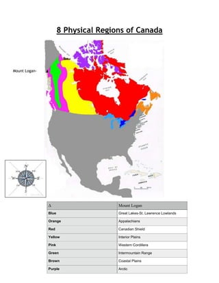
  • 1. 8 Physical Regions of Canada Mount Logan-- Δ Mount Logan Blue Great Lakes-St. Lawrence Lowlands Orange Appalachians Red Canadian Shield Yellow Interior Plains Pink Western Cordillera Green Intermountain Range Brown Coastal Plains Purple Arctic
  • 2. Appalachian Region Topography: • Gentle rolling mountain ranges • Fertile plateaus and river valleys • Contains many 3 000 000 000 year old mountains • Coal, oil and gas can be found in the sedimentary rocks Climate: • Maritime climate • Warmer in the south • • A high temperature from St. John's is 15°C in July A high precipitation from St. John's is 162 mm in December A low temperature from St. John's is -5°C in February • A Low precipitation from St. John's is 78 mm in July Vegetation: • Originally heavily forested • Trees were mixed coniferous and deciduous trees • These survived on both the mountains and on the plateaus and in the valleys Economic Activity: • Mining • Agriculture • Fishing • Logging • Urban economic activity Environmental Concerns: • Over fishing • Over development • Destruction of forest • Pollution •
  • 3. Coastal Plains Topography: Lowlands Has a lot of swamps and marshes Fairly flat Climate: • Maritime climate • Colder north warmer south • • A high temperature from New Jersey is 20°C in July A high precipitation from New Jersey is 101 mm in August A low temperature from New Jersey is 0°C in February • Average low precipitation of 62 mm in June in New Jersey Vegetation: • Some areas were originally pine forest • Quite lush • Some areas are covered in jungle Economic Activity: • Agriculture • Fishing • Urban economic activity Environmental Concerns • Over fishing • Over development • Rising water levels • Pollution •
  • 4. The Great Lakes-St. Lawrence Lowlands Topography: • The Great Lakes section is flat plains broken by gentle rolling hills • The St. Lawrence section is gently rising flat plains • Contains several escarpments Climate: • Continental climate • • A high temperature from Toronto is 20°C in July A high precipitation from Toronto is 78 mm in July A low temperature from Toronto is -5°C in February • A low precipitation from Toronto is 55 mm in February • Humid Vegetation: • Originally heavily treed • Had the largest broad leaf forests in Canada • Main trees were maple, beech, hickory and black walnut Economic Activity: • Farming • Logging • Manufacturing • Urban economic activity Environmental Concerns: • Ground pollution • Destruction of forest • Over development • Pollution •
  • 5. The Interior Plains Topography: • Divided into three different elevations separated by escarpments • Gentle rolling plains • Very flat • Becomes a tundra as you progress north Climate: • Continental climate • • A high temperature from Regina is 20°C in July A high precipitation from Regina is 80 mm in June A low temperature from Regina is -18°C in January • A low precipitation from Regina is 15 mm in December • Northern portion has an Arctic climate Vegetation: • Originally had prairie grass as tall as a man • Originally trees grew in river valleys • Northern portions had boreal forest and became a tundra as it grew nearer to the Arctic Ocean • Wheat and other grains are frequently grown Economic Activity: • Farming (wheat and grains usually) • Mining • Urban economic activity Environmental Concerns: • Over development • Ground pollution • Pollution •
  • 6. The Canadian Shield Topography: • Has a higher elevation in the south then in the north • Has a higher elevation on the outer portions then in the centre • Areas around Hudson Bay and James Bay are lowlands • Has a lot of rivers, lakes, swamps and muskeg Climate: • Mixed continental and maritime climate • Varies over the vast area covered by the Canadian Shield • More and more arctic as you progress north • • A high temperature from Thunder Bay is 15°C in July A high precipitation from Thunder Bay is 60 mm in August in A low temperature from Thunder Bay is -20°C in February • A low precipitation from Thunder Bay is 25 mm in February in Thunder Bay Vegetation: • Mostly boreal forest • Common trees are spruce, pine and fir • There also are some deciduous trees such as poplar and white birch • North of the tree line there are no trees since they can’t take root with the permafrost Economic Activity: • Pulp and paper industry • Mining • Urban economic activity Environmental Concerns • Destruction of forests • Ground pollution • Over exploitation • Pollution •
  • 7. The Western Cordillera Topography: • Ranges of tall, jagged mountains • Younger mountains then the Appalachians • The Rocky Mountains form the continental divide • All water east of the divide flows into the Gulf of Mexico, Arctic Ocean, Hudson Bay and James Bay • All water west of the divide flows into the Pacific Ocean Climate: • Maritime climate • Varies greatly from north to south and east to west • • A high temperature from Vancouver is 20°C in July A high precipitation from Vancouver is 175 mm in December A low temperature from Vancouver is 0°C in February • A low precipitation from Vancouver is 25 mm in July Vegetation: • Varies greatly on each slope of the mountain • On the west side trees such as Douglas Fir, western hemlock and eastern cedar thrive • On the eastern side grasses and cactuses thrive in the dry climate Economic Activity • Logging • Fishing • Urban economic activity Environmental Concerns: • Over fishing • Destruction of forest • Pollution •
  • 8. The Intermountain Range Topography: • On the other side of the Western Cordillera • Many of the rivers in this area never reach the sea but end in brackish lakes or desert sinks while some do make it • Can be very desert like in some areas • Other areas are deserts Climate: • Very dry as it is in the Western Cordilleras rain shadow • • A high temperature from Prince George is 15°C A high precipitation Prince George is 75 mm A low temperature Prince George is -10°C • A low precipitation Prince George is 27 mm Vegetation: • Sparse grass and plants that can survive semi to desert conditions • Higher elevations are covered in thin pine forest Economic Activity: • Ranching • Mining • Farming • Urban economic activity Environmental Concerns: • Ground pollution • Pollution • Over exploitation •
  • 9. The Arctic Topography: • Near the ocean is very flat • Farther north there are mountains covered with glaciers Climate: • The climate is very harsh winter lasts ten months • Summer lasts one month • • A high temperature in Resolute is 3°C in July A high precipitation in Resolute is 25 mm in august A low temperature in Resolute is -35°C in January • A low precipitation in Resolute is 2 mm in January Vegetation • Very few plants can survive up there • The few that can are lichens and small shrubs clinging to the ground Economical Activity: • Fishing • Mining • Urban economic activity Environmental Concerns: • Global warming • Pollution • Over exploitation •
  • 10. Bibliography Cranny, Michael. Crossroads a Meeting of Nations. Scarborough Ontario: RR Donnelley & Sons, 1998. 163-179. Print. Compass Rose. N.d. Photograph. n.p. Web. 17 Feb 2014. <http://www.dreamstime.com/royaltyfree-stock-photo-compass-rose-white-background-image21677385>. "Chapter 6 PDF." Chapter 6 PDF. N.p.. Web. 17 Feb 2014. <http://pgss.sd57.bc.ca/~adavies/vSS9/Intro and Geog/4 Chapter 6.pdf>. Personal experience