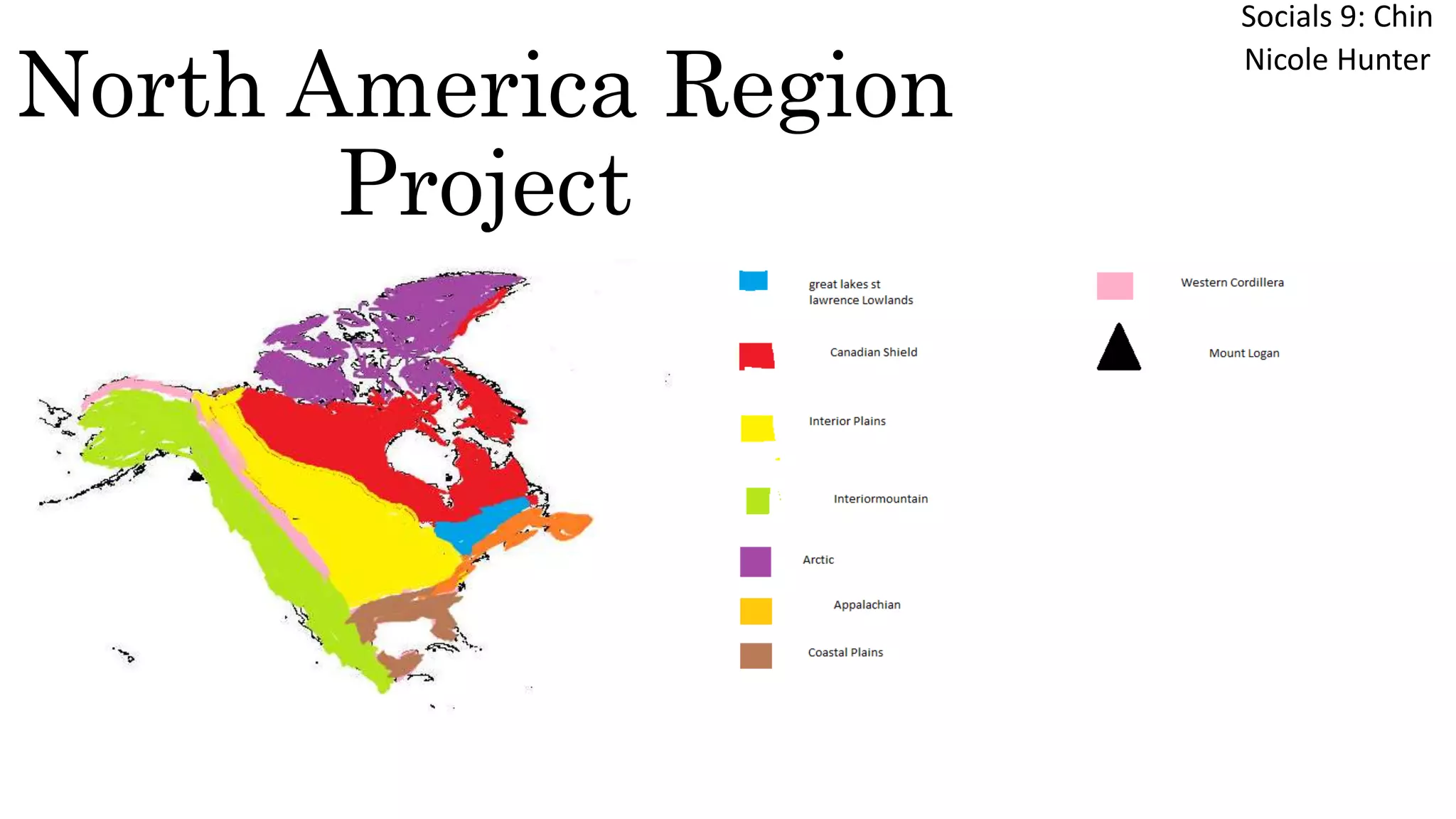
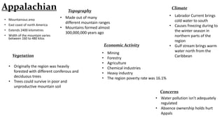
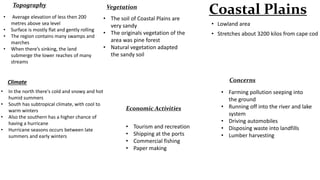
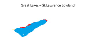
North America Region
Project

Socials 9: Chin
Nicole Hunter
Appalachian
Appalachian
• Mountainous area
• East coast of north America
• Extends 2400 kilometres

• Width of the mountain varies
between 160 to 480 kilos

Climate

Topography
• Made out of many
different mountain ranges
• Mountains formed almost
300,000,000 years ago
Economic Activity

Vegetation
• Originally the region was heavily
forested with different coniferous and
deciduous trees
• Trees could survive in poor and
unproductive mountain soil

•
•
•
•
•
•

Mining
Forestry
Agriculture
Chemical industries
Heavy industry
The region poverty rate was 16.1%

• Labrador Current brings
cold water to south
• Causes freezing during to
the winter season in
northern parts of the
region
• Gulf stream brings warm
water north from the
Caribbean

Concerns
• Water pollution isn’t adequately
regulated
• Absence ownership holds hurt
Appals
Topography
•
•
•
•

Average elevation of less then 200
metres above sea level
Surface is mostly flat and gently rolling
The region contains many swamps and
marches
When there’s sinking, the land
submerge the lower reaches of many
streams

Vegetation

• The soil of Coastal Plains are
very sandy
• The originals vegetation of the
area was pine forest
• Natural vegetation adapted
the sandy soil

•
•
•

In the north there's cold and snowy and hot
humid summers
South has subtropical climate, with cool to
warm winters
Also the southern has a higher chance of
having a hurricane
Hurricane seasons occurs between late
summers and early winters

• Lowland area

• Stretches about 3200 kilos from cape cod

Concerns

Climate
•

Coastal Plains

Economic Activities
•
•
•
•

Tourism and recreation
Shipping at the ports
Commercial fishing
Paper making

• Farming pollution seeping into
the ground
• Running off into the river and lake
system
• Driving automobiles
• Disposing waste into landfills
• Lumber harvesting
Coast Plains
Great Lakes – St.Lawrence Lowland
Great Lakes – St. Lawrence
Lowland
•

Concerns
•

Smallest geographical region in Canada

• Includes the triangle formed by Lake Huron,
Ontario and Erie

•

• Contains many escarpments

•

• Best known being the Niagara Escarpments

Topography
• Has a rolling landscape
• Mainly made by glaciation
• Flat plains are broken by hills and deep river
valleys
• On the St. Lawrence section consist of flat
plains on either side of the river

•

•
•
•

Number of non native species that are taking
over the lakes
Every eight months a new species enters the
great lakes
New animals or insects coming into or leaving
an ecosystem can be just as damaging as
pollution
Most of the food source of most fish in lake
Michigan had being Diporeia
Diporeia shrimp have declined from over 10,000
per square meter to virtually zero on the lake
bottom because of zebra mussels
Lake Michigan the decrease in Deporeia is
extreme high at 44% killed over the past ten
years
Lake Huron is down by 57% in Deporeia
polutation in just in past three years

Climate
•
•
•
•

A humid continental Climate
Humid because of the Great Lakes
Tends to cool during the summer
The great lake warms the surrounding areas
in winter
• Winter vary from cool to cold and warm to
humid

Economic Activities

• Transportation
• Trading post
• Supports multi billion outd
recreation
• Tourism industry
• Extensive agricultural

Vegetation
•
•
•

Originally the region, which has very fertile soils, was
heavily treed
Once had Canada's largest broad-leafed forests, because its
soil and climate conditions aloud maples, beech, hickory,
and black walnuts to thrive
Other places in the region the Vegetation was mixed forest
of both deciduous and conifers
Interior Plains
Interior Plains
• Vast seep of plain

Climate

• Not entirely flat
• Land is composed of gently rolling hills deep river valleys
• In USA, this region runs between Appalachian Mountains
on the east coast, and on the rocky Mountains
• In Canada, this region runs between Canadian Shield and
Rocky Mountains

•
•
•
•
•

Is a continental Climate
Climate of extremes
It has long hot summers, cold winters and
little precipitation
Farther in the north, the winter season are
shorter and cool in the north as well
Northern part of the region has Arctic
climate with really long cold winters

Vegetation
•
•
•
•
•

Originally the Central Lowland east of the
Mississippi was covered with trees and were
scattered evergreens
West of Mississippi in the region, prairie
grasses grew as tall as a person
Natural vegetation of the Canada prairies
was also grassland
Tree grew only in the river valleys
Northern part of the region, boreal forest
grows, gradually becoming tundra towards
the Arctic Ocean

Topography
•
•
•
•
•

Its divide into Central Lowland and Great plains in the
US
Central Lowland is formed by Canadian Shield, St.
Lawrence, and, the Great Lakes
The region is higher in elevation than the Central
Lowland
Its rising about 600 metres to 1500 metres above the
sea level in west
Plains are softly rolling also gradually sloping down
from west to east

Concerns
• Farm pollutants seeping
into the ground
• Separating off into the river
and lake programs
• Incorporate industry

Economic Activities
• Agriculture (split into two
parts)
• Livestock: cattle,pigs,poultry
• Vegetables:
wheat,barley,oats,flax,conola
Canadian Shield
Canadian Shield
• More then 2 billion years old
• Consist of great volcanic mountain
• Mountains were levelled by millions of
years of erosion
• Platform of rocks that stretch from
Labrador, around Hudson Bay and James
Bay

Concerns
• Its not facing enough people
living in it to support the
economy and pay taxes
• Lakes are located where racks
are igneous
• Pollution of the great lakes
• Acid rain

Economic Activities
• Has industry dominated by the
mining of metals and mineral
• Early 1900s Hudson Bay, used land
as a resource for fur trading
• Mining is the logging of the boreal
forest

Topography
Glaciers removed most of the soil
leaving a barren rock surface
Glaciers also affected the drainage of
the shield to a significant degree
Shield consist of a chaotic pattern of
rivers,lakes,swamps and muskeg
Elevation of the Shield is about 100
metres in the south
Middle of the shield is a lot lower in
elevation than its other portion

Vegetation
Climate
• Varies throughout the vast area
• Winter is extremely long and
cold
• Summer is becoming shorter
and cooler

•

Boreal forest covers most of
the shield; spruce, pine, and fir
• Also some deciduous trees
such as: white birch and poplar
• The trees are weak
• The trees are more good for
pulp and paper
Western Cordillera
Western Cordillera
• Runs along the west coast of North America
• Consist of range after range of mountains
• Separate by plateaus and valleys

Topography

• Comprised of new mountains not yet
worm down by erosion
• More then twice as high
• Rivers going east to south

Vegetation

Climate
• Winters are above freezing
• Summers are cool
• Parts of the wettest regions on earth

Concerns
• Construction and development
of the land
• Causes of habitat destruction
in Eco zone
• Lead to death

• Leeward slopes: grass
and cactuses
• Top of mountains
• Vegetation becomes
scarce or crease

Economic Activities
•
•
•
•
•

Fishing
Mining
Orchards
Vineyards
Forestry
Intermountain region
• Area in us and Canada
• Lies between the rocky
mountains and cascades, and
Sierra Nevada
• Thinly populated, high plateaus
• Contain only deserts in the US

Topography
• Stream and rivers never reach the
sea
• They instead, flow into brackish
lakes, such as great salt lake in Utah
• Some rivers do find a way to the
ocean
• There's areas that can be made
productive by irrigation

Concerns
• Many bird habitats are being
destroyed by human actions
• Up to 11 bird species in the
region is endangered
• Because of the dry air, forest
fires can be a problem

Economic Activities
• Cattle ranching
• Irrigation

Climate
• Winter can be cool, wet or hot
• Southern parts of the region,
winters are short and warm
• Northern: Climate is more
moderate
• Moist winters and hot dry
summers

Vegetation
• Ranges between sparse grassland to
plants that can survive in semi deserts
or deserts conditions
• Higher areas are covered in thin pine
Arctic
Arctic

Concerns

• Combination of lowlands and mountains
• Lowlands are found un a series of islands
lying north of Hudson bay

• Mountain are found in extreme
northwest border

Topography
• Near the ocean is very flat
• Mountains of far north were
formed by folding and are covered
by glaciers
• Immense lowlands in the west

•
•
•
•

•

• Melting of the permafrost
• Global warming cold change the
landscape
• Buildings and roads put warmth and
pressure on the permafrost causing
melting
• Invasive species push aside native
vegetation and reduce of the plant
cover
• North and South pole means stronger
ultraviolet rays will harm tundra
Climate
•
Very severe
Its far from the equator
•
Winter lasts for ten months in far
north
Summer is very short and not very •
warm
Some parts of the arctic is covered in •
ice year round

Economic Activities
•
•
•
•
•

Extraction of petroleum and
mineral resources
One tenth of worlds oil
Quarter of its natural gas
Commercial fishing
Traditional hunting, reindeer
herding

Vegetation
Trees can’t grow on the tundra because
the climate is too cold and dry
Only small amounts of thawing occurs
during the summer
Mosses,shrubs,lichens , are the only
things that can grow
They’re attach to ground, soaking up the
moisture and tiny amounts of warmth
that’s there
Mount Logan
Resources
http://www.appalmad.org/
http://www.arc.gov/appalachian_region/TheAppalachianRegion.asp

http://ca.yahoo.com/questions/index?qid=20100505773826AAllqep
www.ask.com/answers/43443121/what-is-an-econmic-activity-in-the-coastal-plains
www.great.lakes.net/econ/
http://ca.yahoo.com/questions/index?qid=20100505773826AAllqep
www.interiorplains.weebly.com/economic-activities.html
gcp.desire2learn.com/d21/lor/viewer/viewfile.d2file/6605/8957/CanadianEnviormentalI
ssuesL12_print html
www.thearctic.is/articles/overviews/changing/enska/index.htm

North america region project

  • 1.
  • 2.
  • 3.
    Appalachian • Mountainous area •East coast of north America • Extends 2400 kilometres • Width of the mountain varies between 160 to 480 kilos Climate Topography • Made out of many different mountain ranges • Mountains formed almost 300,000,000 years ago Economic Activity Vegetation • Originally the region was heavily forested with different coniferous and deciduous trees • Trees could survive in poor and unproductive mountain soil • • • • • • Mining Forestry Agriculture Chemical industries Heavy industry The region poverty rate was 16.1% • Labrador Current brings cold water to south • Causes freezing during to the winter season in northern parts of the region • Gulf stream brings warm water north from the Caribbean Concerns • Water pollution isn’t adequately regulated • Absence ownership holds hurt Appals
  • 4.
    Topography • • • • Average elevation ofless then 200 metres above sea level Surface is mostly flat and gently rolling The region contains many swamps and marches When there’s sinking, the land submerge the lower reaches of many streams Vegetation • The soil of Coastal Plains are very sandy • The originals vegetation of the area was pine forest • Natural vegetation adapted the sandy soil • • • In the north there's cold and snowy and hot humid summers South has subtropical climate, with cool to warm winters Also the southern has a higher chance of having a hurricane Hurricane seasons occurs between late summers and early winters • Lowland area • Stretches about 3200 kilos from cape cod Concerns Climate • Coastal Plains Economic Activities • • • • Tourism and recreation Shipping at the ports Commercial fishing Paper making • Farming pollution seeping into the ground • Running off into the river and lake system • Driving automobiles • Disposing waste into landfills • Lumber harvesting
  • 5.
  • 6.
    Great Lakes –St.Lawrence Lowland
  • 7.
    Great Lakes –St. Lawrence Lowland • Concerns • Smallest geographical region in Canada • Includes the triangle formed by Lake Huron, Ontario and Erie • • Contains many escarpments • • Best known being the Niagara Escarpments Topography • Has a rolling landscape • Mainly made by glaciation • Flat plains are broken by hills and deep river valleys • On the St. Lawrence section consist of flat plains on either side of the river • • • • Number of non native species that are taking over the lakes Every eight months a new species enters the great lakes New animals or insects coming into or leaving an ecosystem can be just as damaging as pollution Most of the food source of most fish in lake Michigan had being Diporeia Diporeia shrimp have declined from over 10,000 per square meter to virtually zero on the lake bottom because of zebra mussels Lake Michigan the decrease in Deporeia is extreme high at 44% killed over the past ten years Lake Huron is down by 57% in Deporeia polutation in just in past three years Climate • • • • A humid continental Climate Humid because of the Great Lakes Tends to cool during the summer The great lake warms the surrounding areas in winter • Winter vary from cool to cold and warm to humid Economic Activities • Transportation • Trading post • Supports multi billion outd recreation • Tourism industry • Extensive agricultural Vegetation • • • Originally the region, which has very fertile soils, was heavily treed Once had Canada's largest broad-leafed forests, because its soil and climate conditions aloud maples, beech, hickory, and black walnuts to thrive Other places in the region the Vegetation was mixed forest of both deciduous and conifers
  • 8.
  • 9.
    Interior Plains • Vastseep of plain Climate • Not entirely flat • Land is composed of gently rolling hills deep river valleys • In USA, this region runs between Appalachian Mountains on the east coast, and on the rocky Mountains • In Canada, this region runs between Canadian Shield and Rocky Mountains • • • • • Is a continental Climate Climate of extremes It has long hot summers, cold winters and little precipitation Farther in the north, the winter season are shorter and cool in the north as well Northern part of the region has Arctic climate with really long cold winters Vegetation • • • • • Originally the Central Lowland east of the Mississippi was covered with trees and were scattered evergreens West of Mississippi in the region, prairie grasses grew as tall as a person Natural vegetation of the Canada prairies was also grassland Tree grew only in the river valleys Northern part of the region, boreal forest grows, gradually becoming tundra towards the Arctic Ocean Topography • • • • • Its divide into Central Lowland and Great plains in the US Central Lowland is formed by Canadian Shield, St. Lawrence, and, the Great Lakes The region is higher in elevation than the Central Lowland Its rising about 600 metres to 1500 metres above the sea level in west Plains are softly rolling also gradually sloping down from west to east Concerns • Farm pollutants seeping into the ground • Separating off into the river and lake programs • Incorporate industry Economic Activities • Agriculture (split into two parts) • Livestock: cattle,pigs,poultry • Vegetables: wheat,barley,oats,flax,conola
  • 10.
  • 11.
    Canadian Shield • Morethen 2 billion years old • Consist of great volcanic mountain • Mountains were levelled by millions of years of erosion • Platform of rocks that stretch from Labrador, around Hudson Bay and James Bay Concerns • Its not facing enough people living in it to support the economy and pay taxes • Lakes are located where racks are igneous • Pollution of the great lakes • Acid rain Economic Activities • Has industry dominated by the mining of metals and mineral • Early 1900s Hudson Bay, used land as a resource for fur trading • Mining is the logging of the boreal forest Topography Glaciers removed most of the soil leaving a barren rock surface Glaciers also affected the drainage of the shield to a significant degree Shield consist of a chaotic pattern of rivers,lakes,swamps and muskeg Elevation of the Shield is about 100 metres in the south Middle of the shield is a lot lower in elevation than its other portion Vegetation Climate • Varies throughout the vast area • Winter is extremely long and cold • Summer is becoming shorter and cooler • Boreal forest covers most of the shield; spruce, pine, and fir • Also some deciduous trees such as: white birch and poplar • The trees are weak • The trees are more good for pulp and paper
  • 12.
  • 13.
    Western Cordillera • Runsalong the west coast of North America • Consist of range after range of mountains • Separate by plateaus and valleys Topography • Comprised of new mountains not yet worm down by erosion • More then twice as high • Rivers going east to south Vegetation Climate • Winters are above freezing • Summers are cool • Parts of the wettest regions on earth Concerns • Construction and development of the land • Causes of habitat destruction in Eco zone • Lead to death • Leeward slopes: grass and cactuses • Top of mountains • Vegetation becomes scarce or crease Economic Activities • • • • • Fishing Mining Orchards Vineyards Forestry
  • 14.
  • 15.
    Intermountain region • Areain us and Canada • Lies between the rocky mountains and cascades, and Sierra Nevada • Thinly populated, high plateaus • Contain only deserts in the US Topography • Stream and rivers never reach the sea • They instead, flow into brackish lakes, such as great salt lake in Utah • Some rivers do find a way to the ocean • There's areas that can be made productive by irrigation Concerns • Many bird habitats are being destroyed by human actions • Up to 11 bird species in the region is endangered • Because of the dry air, forest fires can be a problem Economic Activities • Cattle ranching • Irrigation Climate • Winter can be cool, wet or hot • Southern parts of the region, winters are short and warm • Northern: Climate is more moderate • Moist winters and hot dry summers Vegetation • Ranges between sparse grassland to plants that can survive in semi deserts or deserts conditions • Higher areas are covered in thin pine
  • 16.
  • 17.
    Arctic Concerns • Combination oflowlands and mountains • Lowlands are found un a series of islands lying north of Hudson bay • Mountain are found in extreme northwest border Topography • Near the ocean is very flat • Mountains of far north were formed by folding and are covered by glaciers • Immense lowlands in the west • • • • • • Melting of the permafrost • Global warming cold change the landscape • Buildings and roads put warmth and pressure on the permafrost causing melting • Invasive species push aside native vegetation and reduce of the plant cover • North and South pole means stronger ultraviolet rays will harm tundra Climate • Very severe Its far from the equator • Winter lasts for ten months in far north Summer is very short and not very • warm Some parts of the arctic is covered in • ice year round Economic Activities • • • • • Extraction of petroleum and mineral resources One tenth of worlds oil Quarter of its natural gas Commercial fishing Traditional hunting, reindeer herding Vegetation Trees can’t grow on the tundra because the climate is too cold and dry Only small amounts of thawing occurs during the summer Mosses,shrubs,lichens , are the only things that can grow They’re attach to ground, soaking up the moisture and tiny amounts of warmth that’s there
  • 18.
  • 19.