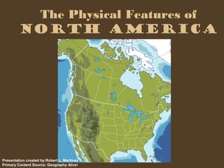
North America is bounded by the Atlantic, Pacific, and Arctic Oceans. It contains two main sub-regions - Canada to the north, which includes islands, lakes, plains and mountains, and the continental United States to the south. The land contains flat areas in the center bounded by mountain ranges along both coasts, with the Canadian Shield covering much of central Canada and the Rocky Mountains running through the western United States. Between these mountain ranges lies wide plains across the central part of the continent.
This presentation covers various aspects of North America, ranging from Geographical, Climatic and Environmental to Business, Life and Style conditions.
This presentation was made by me for one of my friend's Mom.
Hello Friends,
I have made this PPT on the Geography of North America. I have covered almost each and every topic related to it. So, you're welcome!
Thanks!
The Land And Physical Geography Of North AmericaEnamul H
Here's another Geography PPT on the "The Land And Physical Geography Of North America".
feel free to use it at your School, Online class or just anywhere you want. :)
A brief information about the SCOP protein database used in bioinformatics.
The Structural Classification of Proteins (SCOP) database is a comprehensive and authoritative resource for the structural and evolutionary relationships of proteins. It provides a detailed and curated classification of protein structures, grouping them into families, superfamilies, and folds based on their structural and sequence similarities.
(May 29th, 2024) Advancements in Intravital Microscopy- Insights for Preclini...Scintica Instrumentation
Intravital microscopy (IVM) is a powerful tool utilized to study cellular behavior over time and space in vivo. Much of our understanding of cell biology has been accomplished using various in vitro and ex vivo methods; however, these studies do not necessarily reflect the natural dynamics of biological processes. Unlike traditional cell culture or fixed tissue imaging, IVM allows for the ultra-fast high-resolution imaging of cellular processes over time and space and were studied in its natural environment. Real-time visualization of biological processes in the context of an intact organism helps maintain physiological relevance and provide insights into the progression of disease, response to treatments or developmental processes.
In this webinar we give an overview of advanced applications of the IVM system in preclinical research. IVIM technology is a provider of all-in-one intravital microscopy systems and solutions optimized for in vivo imaging of live animal models at sub-micron resolution. The system’s unique features and user-friendly software enables researchers to probe fast dynamic biological processes such as immune cell tracking, cell-cell interaction as well as vascularization and tumor metastasis with exceptional detail. This webinar will also give an overview of IVM being utilized in drug development, offering a view into the intricate interaction between drugs/nanoparticles and tissues in vivo and allows for the evaluation of therapeutic intervention in a variety of tissues and organs. This interdisciplinary collaboration continues to drive the advancements of novel therapeutic strategies.
Multi-source connectivity as the driver of solar wind variability in the heli...Sérgio Sacani
The ambient solar wind that flls the heliosphere originates from multiple
sources in the solar corona and is highly structured. It is often described
as high-speed, relatively homogeneous, plasma streams from coronal
holes and slow-speed, highly variable, streams whose source regions are
under debate. A key goal of ESA/NASA’s Solar Orbiter mission is to identify
solar wind sources and understand what drives the complexity seen in the
heliosphere. By combining magnetic feld modelling and spectroscopic
techniques with high-resolution observations and measurements, we show
that the solar wind variability detected in situ by Solar Orbiter in March
2022 is driven by spatio-temporal changes in the magnetic connectivity to
multiple sources in the solar atmosphere. The magnetic feld footpoints
connected to the spacecraft moved from the boundaries of a coronal hole
to one active region (12961) and then across to another region (12957). This
is refected in the in situ measurements, which show the transition from fast
to highly Alfvénic then to slow solar wind that is disrupted by the arrival of
a coronal mass ejection. Our results describe solar wind variability at 0.5 au
but are applicable to near-Earth observatories.
Richard's entangled aventures in wonderlandRichard Gill
Since the loophole-free Bell experiments of 2020 and the Nobel prizes in physics of 2022, critics of Bell's work have retreated to the fortress of super-determinism. Now, super-determinism is a derogatory word - it just means "determinism". Palmer, Hance and Hossenfelder argue that quantum mechanics and determinism are not incompatible, using a sophisticated mathematical construction based on a subtle thinning of allowed states and measurements in quantum mechanics, such that what is left appears to make Bell's argument fail, without altering the empirical predictions of quantum mechanics. I think however that it is a smoke screen, and the slogan "lost in math" comes to my mind. I will discuss some other recent disproofs of Bell's theorem using the language of causality based on causal graphs. Causal thinking is also central to law and justice. I will mention surprising connections to my work on serial killer nurse cases, in particular the Dutch case of Lucia de Berk and the current UK case of Lucy Letby.
This pdf is about the Schizophrenia.
For more details visit on YouTube; @SELF-EXPLANATORY;
https://www.youtube.com/channel/UCAiarMZDNhe1A3Rnpr_WkzA/videos
Thanks...!
5. The Gulf of Mexico lies to the
south. North America is the third
largest continent in the world.
6. This large region contains two sub-
regions, Canada and Alaska make up the
northern part. The 48 continental United
States makes up the southern part.
7. West of the Great lakes, the two sub-
regions are separated by the 49th
parallel of latitude. East of the Great
Lakes, the St. Lawrence River
separates the two sub-regions.
8. If you look at the physical map of this
region, you see mountains running along
both sides with a large, flat area in the
center. This flat area runs from the Arctic
Ocean to the Gulf of Mexico. It is made up
of shield and plains.
9. The term shield refers to the
large core of very old rock that
lies at the base of each
continent.
10. In North America, this rock core was
exposed thousands of years ago. During
the ice ages, glaciers scraped across the
land, taking the soil with them. They left
just a thin layer of soil in eastern and
central Canada.
11. Plains are flat or gently rolling areas of
land. Much of the soil that glaciers
scraped from the Canadian Shield
ended up on the plains of Canada and
the United States.
12. The Canadian Shield covers
almost half of Canada. The rest of
this sub-region contains islands,
lakes, plains, and mountains.
13. The glaciers that scraped the
shield also dug hug holes that
became the Great Lakes.
14. These lakes lie between Canada and
the United States. They are the world’s
largest group of freshwater lakes. The
St. Lawrence River connects the Great
Lakes to the ocean.
15. To the far north are many smaller lakes
and Hudson Bay. The region extends
past the Arctic Circle and ends with a
scattering of islands.
x
16. In the Atlantic Ocean, off the
southeast coast of Newfoundland, lie
the Grand Banks. The ocean is very
shallow here.
17. Far to the west, in the Alaska Range,
is the highest peak in North
America. Mount McKinley rises
20,320 feet above sea level.
18. Two major mountain ranges run
through the continental United States.
In the east, the Appalachians are a
gentle range of rounded peaks and
deep valleys.
19. In the west, the Rocky Mountains jut
up into jagged, snowcapped peaks.
The Rockies reach all the way from
Alaska to New Mexico.
20. Between these two ranges, wide
plains stretch across the middle
of the continent.
21. This vast, mostly flat region extends
about 2,500 miles north and south.
From the Rockies, the dry and treeless
Great Plains slope down to the central
lowlands.
22. A large system of rivers drains
most of the plains between the
Rocky Mountains and the
Appalachians.
23. These rivers all flow into the
muddy Mississippi River. The
Mississippi empties into the Gulf
of Mexico.