SlideShare a Scribd company logo
1 of 87
Presentation Plus! Glencoe World Geography
Copyright © by The McGraw-Hill Companies, Inc.
Developed by FSCreations, Inc., Cincinnati, Ohio 45202
Send all inquiries to:
GLENCOE DIVISION
Glencoe/McGraw-Hill
8787 Orion Place
Columbus, Ohio 43240
Click the Speaker button
to listen to the audio again.
The lower 48 states of the United States
contain a number of active volcanoes. Two of
the best known are in Washington, on the
Pacific coast: Mount Rainier and Mount Saint
Helens. At 14,410 feet (4,392 m), Mount
Rainier is the third-tallest volcano in North
America. It has been dormant for over a
century. Mount Saint Helens, at a height of
8,365 feet (2,550 m), violently erupted in
1980, killing 57 people and damaging an area
of about 70 sq. mi. (180 sq km).
Landforms
• They include Alaska’s Mount McKinley,
the highest point on the continent. 
• The Rocky Mountains link the United
States and Canada and stretch
northwest from New Mexico to Alaska.
(pages 115–116)
Click the mouse button or press the
Space Bar to display the information.
• The Western Mountains and Plateaus
The western mountains of North America
are called the Pacific Ranges. 
Click the mouse button or press the
Space Bar to display the information.
Landforms (cont.)
• Dry basins and plateaus, featuring
Death Valley and the Grand Canyon,
fill the area between the mountain
ranges. 
(pages 115–116)
• Interior Landforms East of the
Rockies, the land falls and flattens into
the Great Plains, which extend across
the center of North America.
• Eastern Mountains and Lowlands
North America’s oldest mountain chain,
the Appalachians, extends from
Quebec in Canada to Alabama in the
United States. 
Click the mouse button or press the
Space Bar to display the information.
• The Canadian Shield, a giant core of
rock, makes up the eastern half of
Canada and the northeastern United
States.
Landforms (cont.)
(pages 115–116)
Click the mouse button or press the
Space Bar to display the information.
• The Hawaiian Islands in the Pacific are
volcanic mountaintops. 
• Greenland, the world’s largest island,
is just off the coast of Canada’s
Ellesmere Island.
• Islands North American islands
include Manhattan, home to a major
world cultural and financial center, in
the northeast. 
Landforms (cont.)
(pages 115–116)
Which areas of the region would you predict are
the most densely populated? Why do you think
so?
People tend to settle near sources of freshwater
and in mild climates. Mountaintops are too cold
and the deserts are too dry for many people to
live there. People would settle in the Great
Plains because the farmland is rich and
abundant. Some of the islands are probably
crowded, as are most coastal areas where large
cities are located. Other populated areas border
lakes and rivers that serve as transportation
arteries.
Click the mouse button or press the
Space Bar to display the answer.
Landforms (cont.)
(pages 115–116)
Click the mouse button or press the
Space Bar to display the information.
A Fortune in Water
• Water flows west of the Divide toward
the Pacific Ocean and east of the
Divide into the Mississippi River and
the Gulf of Mexico.
• Rivers from the Rockies The high
ridge of the Rockies is called the
Continental Divide. 
(pages 116–119)
Click the mouse button or press the
Space Bar to display the information.
A Fortune in Water (cont.)
• It begins in Minnesota as a stream and
ends as a broad river that empties into
the Gulf of Mexico. 
• The Mississippi drains all or part of 31
U.S. states and 2 Canadian provinces. It
is one of the world’s busiest commercial
waterways.
• The Mighty Mississippi One of North
America’s longest rivers, the Mississippi
flows 2,350 miles (3,782 km) from its
source. 
(pages 116–119)
Click the mouse button or press the
Space Bar to display the information.
• The Canadian cities of Quebec,
Montreal, and Ottawa developed
along the St. Lawrence River and
its tributaries.
• Eastern Rivers The St. Lawrence,
one of Canada’s most important rivers,
forms part of the United States-Canada
border. 
A Fortune in Water (cont.)
(pages 116–119)
• Niagara Falls, located on a river
connecting Lake Ontario and Lake
Erie, is a major source of
hydroelectric power for Canada
and the United States.
A Fortune in Water (cont.)
(pages 116–119)
Click the Speaker button
to listen to the audio again.
A Fortune in Water (cont.)
(pages 116–119)
• The Great Lakes–Lakes Superior, Erie,
Michigan, Ontario, and Huron–are
basins created by glacial activity. 
• The Great Lakes-St. Lawrence Seaway
is a network of canals, rivers, and
waterways linking the Great Lakes with
the Atlantic Ocean.
• From Glaciers to Lakes Glacial dams
created Canada’s Great Bear Lake and
Great Slave Lake. 
Click the mouse button or press the
Space Bar to display the information.
A Fortune in Water (cont.)
(pages 116–119)
What is the importance of the Mississippi
River in U.S. history and economics?
Explain.
The river stretches almost the full length
of the country’s interior, so it provides a
means for transporting people and goods.
European explorers used the Mississippi
to venture into new territories.
Click the mouse button or press the
Space Bar to display the answer.
A Fortune in Water (cont.)
(pages 116–119)
Click the mouse button or press the
Space Bar to display the information.
Natural Resources
• Fuels An abundance of resources,
such as fossil fuels and minerals, has
contributed to the prosperity of the
United States and Canada.
(pages 119–120)
Click the mouse button or press the
Space Bar to display the information.
• Minerals Gold, silver, and copper are
found in the Rocky Mountains. Nickel
and iron are mined in parts of the
Canadian Shield. 
(pages 119–120)
Natural Resources (cont.)
• Deposits of low-grade iron ore exist
in northern Minnesota and Michigan. 
• Canada supplies much of the world’s
potash, copper, and silver.
Click the Speaker button
to listen to the audio again.
Natural Resources (cont.)
(pages 119–120)
• Commercial loggers face the challenge
of harvesting trees while preserving the
remaining forests.
• Timber Today forests cover less than
50 percent of Canada and just 30
percent of the United States. 
Click the mouse button or press the
Space Bar to display the information.
Natural Resources (cont.)
(pages 119–120)
• Because of overfishing, however, the
Grand Banks, off Canada’s southeast
coast, are now off limits to cod fishers.
• Fishing The coastal waters of the
Atlantic and Pacific Oceans and the
Gulf of Mexico are important sources
of fish and other sea animals. 
Click the mouse button or press the
Space Bar to display the information.
Natural Resources (cont.)
(pages 119–120)
Click the Speaker button
to listen to the audio again.
Natural Resources (cont.)
(pages 119–120)
Click the Speaker button
to listen to the audio again.
Tornadoes are a common phenomenon in
the Great Plains region. “Tornado” comes
from the Spanish word for thunderstorm.
Tornadoes are usually brief, but they are
very destructive. During the 1990s alone,
378 people lost their lives in tornadoes in
the United States.
A Varied Region
• Most of the continental United States
and the southern one-third of Canada
enjoy temperate climates, depending
on elevation. 
• Hawaii, in the South Pacific, has a
tropical climate.
• Two-thirds of Canada and the U.S. state
of Alaska experience long, cold winters
and brief, mild summers. 
Click the mouse button or press the
Space Bar to display the information.
(page 121)
Which climate regions in the United
States and Canada do you think attract
the greatest number of people?
Explain.
Possible answer: Many people prefer
living in mid-latitude and tropical
climates because of relatively mild or
warm temperatures and the variety of
ways of earning a living.
A Varied Region (cont.)
Click the mouse button or press the
Space Bar to display the answer.
(page 121)
Click the mouse button or press the
Space Bar to display the information.
Northern Climates
• Winter temperatures can fall as low as
-70ºF (–57ºC).
• Large parts of Canada and Alaska lie in
a subarctic climate zone with very cold
winters and extensive coniferous
forests. 
(page 122)
Click the mouse button or press the
Space Bar to display the information.
Northern Climates (cont.)
• Greenland boasts only a few ice-free
areas with some extremely hardy trees.
• Bitter winters and cool summers in the
tundra along the Arctic coastline make
the area unsuitable for most plants or
people. 
(page 122)
What everyday effects does climate have on
people who live in subarctic and tundra climate
zones?
They probably spend a lot of their time indoors.
They must wear layers of warm clothing and
heavy socks and boots. For travel, they need
vehicles that function in icy conditions. They
must take precautions against frostbite. They
need to keep their kitchens stocked with
supplies for the times when they are snowed in.
Many fresh fruits and vegetables are expensive
or unavailable. Occupational opportunities are
limited.
Northern Climates (cont.)
Click the mouse button or press the
Space Bar to display the answer.
(page 122)
Click the mouse button or press the
Space Bar to display the information.
Western Climates
• This amount of precipitation, combined
with cool temperatures, is ideal for
coniferous forests, ferns, and mosses.
(pages 122–124)
• Marine West Coast A marine west coast
climate brings nearly 100 inches (254
cm) of rainfall every year to the Pacific
coast from California to southern Alaska.

Western Climates (cont.)
- The region between the Pacific Ranges and
the Rocky Mountains includes deserts and
steppes. 
- The weather is hot and dry. Cacti and
wildflowers bloom during the brief spring
rains. 
- Elevation gives the higher reaches of
the Rocky Mountains and Pacific
Ranges a highlands climate.
• Plateaus, Basins, and Deserts 
Click the mouse button or press the
Space Bar to display the information.
(pages 122–124)
Western Climates (cont.)
- In the spring, the warm, dry chinook wind
thaws the snows at the base of
the eastern slopes of the Rockies.
- Beyond the timberline, coniferous forests
give way to only lichens and mosses. 
Click the mouse button or press the
Space Bar to display the information.
(pages 122–124)
Why are trees unable to grow on high
mountaintops?
At high altitudes, the temperatures are
too cold for trees to grow. Soils are
generally shallow, rocky, and frozen,
so seeds do not germinate.
Click the mouse button or press the
Space Bar to display the answer.
Western Climates (cont.)
(pages 122–124)
Interior Climates
Click the mouse button or press the
Space Bar to display the information.
• Some prairie grasses grow up to 12
feet high (3.7 m) as a result of rainfall
ranging from 10 to 30 inches (26 to 76
cm) every year.
• Prairies Prairies, or naturally treeless
expanses of grasses, spread across
North America’s midsection. 
(pages 124–125)
Interior Climates (cont.)
• During the 1930s, several seasons of
drought and dry winds blew the soil
away, and the area was nicknamed the
Dust Bowl.
• The Dust Bowl When farmers settled
the Great Plains, they plowed up the sod
formed by prairie grasses, leaving the
soil without protection. 
Click the mouse button or press the
Space Bar to display the information.
(pages 124–125)
Click the Speaker button
to listen to the audio again.
(pages 122–124)
Interior Climates (cont.)
What steps have farmers today taken to
prevent future dust-bowl disasters?
Farmers have planted shelter belts of
trees to moderate wind damage, rotated
crops, allowed some areas to remain in
grass, adopted no-till farming practices,
contour plowed to conserve moisture,
and planted cover crops. Many
participate in government-sponsored
conservation programs.
Click the mouse button or press the
Space Bar to display the answer.
Interior Climates (cont.)
(pages 124–125)
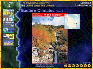
Eastern Climates
Click the mouse button or press the
Space Bar to display the information.
• Much of the original deciduous forest
has been cleared for agriculture. 
• Wetlands and swamps shelter a great
variety of plants and animals. 
• Every summer, the region prepares for
hurricanes.
• The southeastern United States, with
a humid subtropical climate, has mild
winters and long, muggy summers. 
(page 125)
Click the mouse button or press the
Space Bar to display the information.
Eastern Climates (cont.)
• Much of this area is prone to winter
blizzards–snowstorms with high winds,
heavy or blowing snow, and little
visibility.
• The northeastern United States and
southeastern Canada have a humid
continental climate with bands of
deciduous and mixed forestland. 
(page 125)
Click the Speaker button
to listen to the audio again.
Eastern Climates (cont.)
(page 125)
Click the mouse button or press the
Space Bar to display the answer.
In which region would you prefer to
live? Why?
Possible answers: The Northeast,
because the climate changes during
each of the four seasons, or the South,
because the winters are mild.
Eastern Climates (cont.)
(page 125)
Click the mouse button or press the
Space Bar to display the information.
• Southern Florida has a tropical savanna
area, and both Hawaii and Puerto Rico
have tropical rain forests.
• Hawaii, Puerto Rico, and the southern
tip of Florida have tropical climates. 
Tropical Climates
(page 125)
Tropical Climates (cont.)
Click the mouse button or press the
Space Bar to display the answer.
Why is southern Florida the only place in
the continental United States to have a
tropical climate, and what kind of tropical
climate exists there?
Florida’s southern tip lies in the low
latitudes. The rest of the continental
United States is too far north to have
tropical climates. Florida’s tropical
savanna climate zone has seasonal rains,
vast grasslands, and high temperatures
year-round. (page 125)
• Canada and the continental United States
have similar landforms, shaped by similar
geologic processes. 
Section 1: The Land (pages 115–120)
• Both have high, sharp mountains and dry
plateaus in the west; rolling, grassy plains in
the center; and lower, older mountains and
coastal lowlands in the east. 
• The region’s waterways, including rivers, lakes,
coastal waters, and intracoastal channels,
played a vital role in settling the land and
continue to serve as commercial highways.
Key Points
Click the mouse button or press the
Space Bar to display the information.
• The Continental Divide divides the region into
two large drainage areas. 
Section 1: The Land (pages 115–120)
• To the east of the Divide, waters flow to the
Arctic Ocean, to Hudson Bay, to the Atlantic
Ocean, or to the Gulf of Mexico. To the west,
they flow into the Pacific Ocean. 
• Glacial movement shaped much of the North
American landscape. 
• The geologic factors that shaped the United
States and Canada also provided the region
with a wealth of natural resources.
Key Points
Click the mouse button or press the
Space Bar to display the information.
• The region encompassing the United States
and Canada experiences a great variety of
climates. 
• Some climate regions of the United States and
Canada are influenced primarily by latitude. 
• Wind, ocean currents, rainfall patterns, and
elevation moderate the effects of latitude in
other climate zones of the United States and
Canada.
Click the mouse button or press the
Space Bar to display the information.
Key Points
Section 2: Climate and Vegetation
(pages 121–125)
• Climatic factors cause hazardous seasonal
weather patterns in the United States and
Canada, including spring and summer
tornadoes, and summer and fall hurricanes,
and winter blizzards. 
• The region’s natural vegetation reflects its
climatic variety, but human interaction with the
environment has greatly altered natural
vegetation.
Click the mouse button or press the
Space Bar to display the information.
Key Points
Section 2: Climate and Vegetation
(pages 121–125)
Click the mouse button or press the
Space Bar to display the answers.
Reviewing Key Terms
Insert the key term that best completes each of the
following sentences.
chinook fall line fisheries
prairies supercell timberline
tributary headwaters divide
1. ___________________ supply great quantities of
fish and other sea animals to North America.
2. The warm, dry wind, or ___________________
melts snow at the base of the Rockies.
3. Lichens and mosses grow above the
___________________.
4. Spring and summer tornadoes are spawned by a
violent thunderstorm called a(n)
___________________.
Fisheries
chinook
timberline
supercell
Click the mouse button or press the
Space Bar to display the answers.
5. Farmers on the wide grasslands, or
___________________ of the Great Plains broke
up sod to grow crops.
6. Many North American rivers have their
___________________, or source, in the Rocky
Mountains, where a(n) ___________________
determines the direction of the rivers’ flow.
Reviewing Key Terms
prairies
divide
Insert the key term that best completes each of the
following sentences.
chinook fall line fisheries
prairies supercell timberline
tributary headwaters divide
headwaters
Click the mouse button or press the
Space Bar to display the answers.
7. Important cities grew up along the
___________________, where the Piedmont
drops to the Atlantic Coastal Plain.
8. A(n) ___________________ of the Mississippi
River may be a stream or small river.
Reviewing Key Terms
fall line
tributary
Insert the key term that best completes each of the
following sentences.
chinook fall line fisheries
prairies supercell timberline
tributary headwaters divide
Click the mouse button or press the
Space Bar to display the answer.
How were the Pacific Ranges formed?
The Pacific Ranges were formed by
collisions between the Pacific and the
North American tectonic plates millions
of years ago.
Reviewing Facts
Section 1: The Land
Click the mouse button or press the
Space Bar to display the answer.
What effect does the Continental Divide
have on the direction rivers flow?
Waters west of the Continental Divide flow
into the Pacific Ocean. Waters east of the
divide flow into the Mississippi River
system and then into the Gulf of Mexico.
Reviewing Facts
Section 1: The Land
Click the mouse button or press the
Space Bar to display the answer.
What kind of climate is common in most of
the United States and southern Canada?
Climates typical of mid-latitudes that vary
with elevation are common in most of the
United States and southern Canada.
Reviewing Facts
Section 2: Climate and Vegetation
Click the mouse button or press the
Space Bar to display the answer.
Name two types of vegetation in this region.
Mixed deciduous-coniferous forest and
grasslands are found in the United States
and southern Canada.
Reviewing Facts
Section 2: Climate and Vegetation
Click the mouse button or press the
Space Bar to display the answer.
Critical Thinking
Analyzing Information What geologic
processes shaped much of this region?
Collision of tectonic plates and the
movement of glaciers shaped much of
this region.
Click the mouse button or press the
Space Bar to display the answer.
Critical Thinking
Drawing Conclusions Why should the
United States and Canada protect their
natural vegetation?
Possible answer: The United States and
Canada should protect their natural
vegetation to prevent massive erosion and
loss of topsoil such as that which occurred
during the Dust Bowl era.
Click the mouse button or press the
Space Bar to display the answers.
Locating Places
Match the letters on the map with the physical features of
the United States and Canada. Write your answers on a
sheet of paper.
__1. Rocky Mountains
__2. Great Plains
__3. Appalachian
Mountains
__4. Canadian Shield
__5. Great Lakes
__6. Mississippi River
J
F
K
L
A
C
Click the mouse button or press the
Space Bar to display the answers.
Locating Places
Match the letters on the map with the physical features of
the United States and Canada. Write your answers on a
sheet of paper.
__7. Hudson Bay
__8. Great Bear Lake
__9. Pacific Ranges
__10. Mackenzie River
__11. Rio Grande
__12. Great Slave Lake
G
D
B
I
H
E
Click the mouse button or press the
Space Bar to display the answer.
Why is vegetation in the United States
more varied than that in Canada?
The United States has more climate
zones, from subarctic to tropical. These
zones help determine what types of
vegetation will grow in a certain area.
Explore online information about the topics
introduced in this chapter.
Click on the Connect button to launch your browser and go to the
Glencoe World Geography Web site. At this site, you will find
interactive activities, current events information, and Web sites
correlated with the chapters and units in the textbook. When you
finish exploring, exit the browser program to return to this
presentation. If you experience difficulty connecting to the Web
site, manually launch your Web browser and go to
http://geography.glencoe.com
Choose the best answer for the following multiple-
choice question. If you have trouble answering the
question, use the process of elimination to narrow
your choices.
1. Given the information shown in the bar graph on page 129 of your
textbook, which city is most likely located east of the fall line in the
eastern United States?
A City 1
B City 2
C City 3
D City 4
Click the mouse button or press the
Space Bar to display the answer.
Test-Taking Tip To determine which city is east of the fall line,
remember that the fall line is where the higher land of the Piedmont
drops to the lower Atlantic Coastal Plain to the east. Eliminate those
choices that do not indicate a city on the coast, near sea level.
The Appalachian Trail
The National Geographic Society Tree
Click on a hyperlink to view the corresponding slide.
The Appalachian Trail is a 2,000 mile (3,200 km)
hiking path through some of the most beautiful
scenery in the eastern United States. Earl V. Shaffer
distinguished himself by being the first person to hike
the entire trail in 1949, the first to hike the trail in both
directions, and, in 1999 at the age of 80, the oldest
person to complete the trek from Mount Katahdin in
Maine to Springer Mountain in Georgia.
The National Geographic Society Tree, a coast
redwood growing in California’s Redwood National
Park, is a leading contender for the world’s tallest
living tree. Measured in 1995 at 365.5 feet (111 m),
the tree has branches that sweep in 50-foot (15-m)
arcs.
Geology The Canadian Shield is a horseshoe-
shaped expanse of rock that covers half of Canada.
Some of the rock formations in the Canadian Shield
are 2 billion to 4 billion years old, making them some
of the oldest formations in the world.
The Dust Bowl Writer John Steinbeck chronicled
the plight of those who lost their farms in the
Dust Bowl in his Pulitzer Prize-winning novel,
The Grapes of Wrath, written in 1939.
Reading a Relief Map
When you plan a walk, do you prefer an easy stroll along flat
ground, or do you look for a challenging hike up and down
steep hills? By using a relief map, you can determine the
elevation of the terrain you are going to cover.
Learning the Skill
A relief map is a special purpose map that shows variation in
height, or elevation, of land areas. All elevation is measured
from sea level, the average level of water in the world’s
oceans. Mapmakers label this elevation level zero feet (0 m).
The actual elevation of some places is shown as a negative
number because they lie below sea level. 
It is not possible for a relief map to show the elevation of
every single inch of land. As a result, areas are grouped
together. A map may show all areas with an elevation
between sea level and 1,000 feet (305 m) colored green.
Within that area no hill will be higher than 1,000 feet (305 m)
and no valley lower than sea level.
Click the mouse button or press the
Space Bar to display the information.
Reading a Relief Map
Follow these steps to read a relief map: 
Learning the Skill
Click the mouse button or press the
Space Bar to display the information.
• Note the title of the map. 
• Study the map key. Relief maps generally use colors or
shaded areas to identify elevation. 
• Compare the relief map with other maps. Observe how
elevation affects climate, population distribution, and
economic activity in an area.
Reading a Relief Map
Practicing the Skill
Refer to the relief map on page 126 of your textbook to
answer the following questions.
1. What is the color of the map’s highest elevation?
2. What elevation range does the color green indicate in
feet? In meters?
The color of the highest elevation is orange.
Click the mouse button or press the
Space Bar to display possible answers.
The color green indicates 0 to 1,000 feet, or 0 to 300
meters.
Reading a Relief Map
Click the mouse button or press the
Space Bar to display possible answers.
Practicing the Skill
3. What color is the elevation range of 2,000 to 5,000 feet
(600 m to 1,500 m)?
4. At what elevation is the state of Mississippi?
The color of the elevation range is light orange.
The elevation of Mississippi is 0 to 1,000 feet.
Refer to the relief map on page 126 of your textbook to
answer the following questions.
Reading a Relief Map
Click the mouse button or press the
Space Bar to display possible answer.
5. What are the elevation levels as you travel west from New
Jersey to Ohio?
Practicing the Skill
The elevation levels are from 0 to 5,000 feet.
Refer to the relief map on page 126 of your textbook to
answer the following questions.
Reading a Relief Map
Maps
The United States and Canada: Physical-Political
The United States and Canada: Climate Regions
The United States and Canada: Natural Vegetation
Click on a hyperlink to view the corresponding slide.
Click the mouse button or press the
Space Bar to display the answer.
Click the mouse button or press the
Space Bar to display the answer.
Latitude; the average
temperature
decreases as
latitude increases.
End of Custom Shows
WARNING! Do Not Remove
This slide is intentionally blank and is set to auto-advance to end custom
shows and return to the main presentation.
4939081.ppt

More Related Content

Similar to 4939081.ppt

Nature in the U.S.A.
Nature in the U.S.A.Nature in the U.S.A.
Nature in the U.S.A.Daniela Arrus
 
ITFT- america physical Features
ITFT-  america physical FeaturesITFT-  america physical Features
ITFT- america physical FeaturesAruna Poddar
 
Mt St Helens Geography Case Study
Mt St Helens Geography Case StudyMt St Helens Geography Case Study
Mt St Helens Geography Case Studyanicholls1234
 
5.1 - North American Landforms and Resources
5.1 - North American Landforms and Resources5.1 - North American Landforms and Resources
5.1 - North American Landforms and ResourcesDan Ewert
 
Geography of the united states
Geography of the united statesGeography of the united states
Geography of the united statesAaron Carn
 
Geographical position of the USA.ppt
Geographical position of the USA.pptGeographical position of the USA.ppt
Geographical position of the USA.pptLigeeya
 
Notes for intro unit2
Notes for intro unit2Notes for intro unit2
Notes for intro unit2aadb41
 
3.1 North American Geography
3.1 North American Geography3.1 North American Geography
3.1 North American GeographySandy Anthony
 
North American Geography
North American GeographyNorth American Geography
North American GeographySandy Anthony
 
United states of america complet2
United states of america complet2United states of america complet2
United states of america complet2judith-school
 
The 8 physical regions of north america
The 8 physical regions of north americaThe 8 physical regions of north america
The 8 physical regions of north americaJake Rablou
 

Similar to 4939081.ppt (20)

North America
North AmericaNorth America
North America
 
Nature in the U.S.A.
Nature in the U.S.A.Nature in the U.S.A.
Nature in the U.S.A.
 
ITFT- america physical Features
ITFT-  america physical FeaturesITFT-  america physical Features
ITFT- america physical Features
 
Mt St Helens Geography Case Study
Mt St Helens Geography Case StudyMt St Helens Geography Case Study
Mt St Helens Geography Case Study
 
North America.docx
North America.docxNorth America.docx
North America.docx
 
Mexico
MexicoMexico
Mexico
 
English day
English dayEnglish day
English day
 
Latin America
Latin AmericaLatin America
Latin America
 
5.1 - North American Landforms and Resources
5.1 - North American Landforms and Resources5.1 - North American Landforms and Resources
5.1 - North American Landforms and Resources
 
Geography of the united states
Geography of the united statesGeography of the united states
Geography of the united states
 
Geographical position of the USA.ppt
Geographical position of the USA.pptGeographical position of the USA.ppt
Geographical position of the USA.ppt
 
North America
North America North America
North America
 
Chapter 4 Anglo America (US& Canada)
Chapter 4 Anglo America (US& Canada)Chapter 4 Anglo America (US& Canada)
Chapter 4 Anglo America (US& Canada)
 
Ca geog intro
Ca geog introCa geog intro
Ca geog intro
 
Notes for intro unit2
Notes for intro unit2Notes for intro unit2
Notes for intro unit2
 
3.1 North American Geography
3.1 North American Geography3.1 North American Geography
3.1 North American Geography
 
North American Geography
North American GeographyNorth American Geography
North American Geography
 
United states of america complet2
United states of america complet2United states of america complet2
United states of america complet2
 
Usa
UsaUsa
Usa
 
The 8 physical regions of north america
The 8 physical regions of north americaThe 8 physical regions of north america
The 8 physical regions of north america
 

Recently uploaded

Z Score,T Score, Percential Rank and Box Plot Graph
Z Score,T Score, Percential Rank and Box Plot GraphZ Score,T Score, Percential Rank and Box Plot Graph
Z Score,T Score, Percential Rank and Box Plot GraphThiyagu K
 
BASLIQ CURRENT LOOKBOOK LOOKBOOK(1) (1).pdf
BASLIQ CURRENT LOOKBOOK  LOOKBOOK(1) (1).pdfBASLIQ CURRENT LOOKBOOK  LOOKBOOK(1) (1).pdf
BASLIQ CURRENT LOOKBOOK LOOKBOOK(1) (1).pdfSoniaTolstoy
 
Beyond the EU: DORA and NIS 2 Directive's Global Impact
Beyond the EU: DORA and NIS 2 Directive's Global ImpactBeyond the EU: DORA and NIS 2 Directive's Global Impact
Beyond the EU: DORA and NIS 2 Directive's Global ImpactPECB
 
9548086042 for call girls in Indira Nagar with room service
9548086042  for call girls in Indira Nagar  with room service9548086042  for call girls in Indira Nagar  with room service
9548086042 for call girls in Indira Nagar with room servicediscovermytutordmt
 
Web & Social Media Analytics Previous Year Question Paper.pdf
Web & Social Media Analytics Previous Year Question Paper.pdfWeb & Social Media Analytics Previous Year Question Paper.pdf
Web & Social Media Analytics Previous Year Question Paper.pdfJayanti Pande
 
Russian Escort Service in Delhi 11k Hotel Foreigner Russian Call Girls in Delhi
Russian Escort Service in Delhi 11k Hotel Foreigner Russian Call Girls in DelhiRussian Escort Service in Delhi 11k Hotel Foreigner Russian Call Girls in Delhi
Russian Escort Service in Delhi 11k Hotel Foreigner Russian Call Girls in Delhikauryashika82
 
Software Engineering Methodologies (overview)
Software Engineering Methodologies (overview)Software Engineering Methodologies (overview)
Software Engineering Methodologies (overview)eniolaolutunde
 
fourth grading exam for kindergarten in writing
fourth grading exam for kindergarten in writingfourth grading exam for kindergarten in writing
fourth grading exam for kindergarten in writingTeacherCyreneCayanan
 
Paris 2024 Olympic Geographies - an activity
Paris 2024 Olympic Geographies - an activityParis 2024 Olympic Geographies - an activity
Paris 2024 Olympic Geographies - an activityGeoBlogs
 
Disha NEET Physics Guide for classes 11 and 12.pdf
Disha NEET Physics Guide for classes 11 and 12.pdfDisha NEET Physics Guide for classes 11 and 12.pdf
Disha NEET Physics Guide for classes 11 and 12.pdfchloefrazer622
 
Arihant handbook biology for class 11 .pdf
Arihant handbook biology for class 11 .pdfArihant handbook biology for class 11 .pdf
Arihant handbook biology for class 11 .pdfchloefrazer622
 
Student login on Anyboli platform.helpin
Student login on Anyboli platform.helpinStudent login on Anyboli platform.helpin
Student login on Anyboli platform.helpinRaunakKeshri1
 
Advanced Views - Calendar View in Odoo 17
Advanced Views - Calendar View in Odoo 17Advanced Views - Calendar View in Odoo 17
Advanced Views - Calendar View in Odoo 17Celine George
 
Ecosystem Interactions Class Discussion Presentation in Blue Green Lined Styl...
Ecosystem Interactions Class Discussion Presentation in Blue Green Lined Styl...Ecosystem Interactions Class Discussion Presentation in Blue Green Lined Styl...
Ecosystem Interactions Class Discussion Presentation in Blue Green Lined Styl...fonyou31
 
Q4-W6-Restating Informational Text Grade 3
Q4-W6-Restating Informational Text Grade 3Q4-W6-Restating Informational Text Grade 3
Q4-W6-Restating Informational Text Grade 3JemimahLaneBuaron
 
Measures of Dispersion and Variability: Range, QD, AD and SD
Measures of Dispersion and Variability: Range, QD, AD and SDMeasures of Dispersion and Variability: Range, QD, AD and SD
Measures of Dispersion and Variability: Range, QD, AD and SDThiyagu K
 
Introduction to Nonprofit Accounting: The Basics
Introduction to Nonprofit Accounting: The BasicsIntroduction to Nonprofit Accounting: The Basics
Introduction to Nonprofit Accounting: The BasicsTechSoup
 

Recently uploaded (20)

Z Score,T Score, Percential Rank and Box Plot Graph
Z Score,T Score, Percential Rank and Box Plot GraphZ Score,T Score, Percential Rank and Box Plot Graph
Z Score,T Score, Percential Rank and Box Plot Graph
 
BASLIQ CURRENT LOOKBOOK LOOKBOOK(1) (1).pdf
BASLIQ CURRENT LOOKBOOK  LOOKBOOK(1) (1).pdfBASLIQ CURRENT LOOKBOOK  LOOKBOOK(1) (1).pdf
BASLIQ CURRENT LOOKBOOK LOOKBOOK(1) (1).pdf
 
Beyond the EU: DORA and NIS 2 Directive's Global Impact
Beyond the EU: DORA and NIS 2 Directive's Global ImpactBeyond the EU: DORA and NIS 2 Directive's Global Impact
Beyond the EU: DORA and NIS 2 Directive's Global Impact
 
9548086042 for call girls in Indira Nagar with room service
9548086042  for call girls in Indira Nagar  with room service9548086042  for call girls in Indira Nagar  with room service
9548086042 for call girls in Indira Nagar with room service
 
Web & Social Media Analytics Previous Year Question Paper.pdf
Web & Social Media Analytics Previous Year Question Paper.pdfWeb & Social Media Analytics Previous Year Question Paper.pdf
Web & Social Media Analytics Previous Year Question Paper.pdf
 
Russian Escort Service in Delhi 11k Hotel Foreigner Russian Call Girls in Delhi
Russian Escort Service in Delhi 11k Hotel Foreigner Russian Call Girls in DelhiRussian Escort Service in Delhi 11k Hotel Foreigner Russian Call Girls in Delhi
Russian Escort Service in Delhi 11k Hotel Foreigner Russian Call Girls in Delhi
 
Software Engineering Methodologies (overview)
Software Engineering Methodologies (overview)Software Engineering Methodologies (overview)
Software Engineering Methodologies (overview)
 
INDIA QUIZ 2024 RLAC DELHI UNIVERSITY.pptx
INDIA QUIZ 2024 RLAC DELHI UNIVERSITY.pptxINDIA QUIZ 2024 RLAC DELHI UNIVERSITY.pptx
INDIA QUIZ 2024 RLAC DELHI UNIVERSITY.pptx
 
fourth grading exam for kindergarten in writing
fourth grading exam for kindergarten in writingfourth grading exam for kindergarten in writing
fourth grading exam for kindergarten in writing
 
Paris 2024 Olympic Geographies - an activity
Paris 2024 Olympic Geographies - an activityParis 2024 Olympic Geographies - an activity
Paris 2024 Olympic Geographies - an activity
 
Advance Mobile Application Development class 07
Advance Mobile Application Development class 07Advance Mobile Application Development class 07
Advance Mobile Application Development class 07
 
Disha NEET Physics Guide for classes 11 and 12.pdf
Disha NEET Physics Guide for classes 11 and 12.pdfDisha NEET Physics Guide for classes 11 and 12.pdf
Disha NEET Physics Guide for classes 11 and 12.pdf
 
Arihant handbook biology for class 11 .pdf
Arihant handbook biology for class 11 .pdfArihant handbook biology for class 11 .pdf
Arihant handbook biology for class 11 .pdf
 
Mattingly "AI & Prompt Design: Structured Data, Assistants, & RAG"
Mattingly "AI & Prompt Design: Structured Data, Assistants, & RAG"Mattingly "AI & Prompt Design: Structured Data, Assistants, & RAG"
Mattingly "AI & Prompt Design: Structured Data, Assistants, & RAG"
 
Student login on Anyboli platform.helpin
Student login on Anyboli platform.helpinStudent login on Anyboli platform.helpin
Student login on Anyboli platform.helpin
 
Advanced Views - Calendar View in Odoo 17
Advanced Views - Calendar View in Odoo 17Advanced Views - Calendar View in Odoo 17
Advanced Views - Calendar View in Odoo 17
 
Ecosystem Interactions Class Discussion Presentation in Blue Green Lined Styl...
Ecosystem Interactions Class Discussion Presentation in Blue Green Lined Styl...Ecosystem Interactions Class Discussion Presentation in Blue Green Lined Styl...
Ecosystem Interactions Class Discussion Presentation in Blue Green Lined Styl...
 
Q4-W6-Restating Informational Text Grade 3
Q4-W6-Restating Informational Text Grade 3Q4-W6-Restating Informational Text Grade 3
Q4-W6-Restating Informational Text Grade 3
 
Measures of Dispersion and Variability: Range, QD, AD and SD
Measures of Dispersion and Variability: Range, QD, AD and SDMeasures of Dispersion and Variability: Range, QD, AD and SD
Measures of Dispersion and Variability: Range, QD, AD and SD
 
Introduction to Nonprofit Accounting: The Basics
Introduction to Nonprofit Accounting: The BasicsIntroduction to Nonprofit Accounting: The Basics
Introduction to Nonprofit Accounting: The Basics
 

4939081.ppt

  • 1. Presentation Plus! Glencoe World Geography Copyright © by The McGraw-Hill Companies, Inc. Developed by FSCreations, Inc., Cincinnati, Ohio 45202 Send all inquiries to: GLENCOE DIVISION Glencoe/McGraw-Hill 8787 Orion Place Columbus, Ohio 43240
  • 2.
  • 3.
  • 4. Click the Speaker button to listen to the audio again.
  • 5. The lower 48 states of the United States contain a number of active volcanoes. Two of the best known are in Washington, on the Pacific coast: Mount Rainier and Mount Saint Helens. At 14,410 feet (4,392 m), Mount Rainier is the third-tallest volcano in North America. It has been dormant for over a century. Mount Saint Helens, at a height of 8,365 feet (2,550 m), violently erupted in 1980, killing 57 people and damaging an area of about 70 sq. mi. (180 sq km).
  • 6. Landforms • They include Alaska’s Mount McKinley, the highest point on the continent.  • The Rocky Mountains link the United States and Canada and stretch northwest from New Mexico to Alaska. (pages 115–116) Click the mouse button or press the Space Bar to display the information. • The Western Mountains and Plateaus The western mountains of North America are called the Pacific Ranges. 
  • 7. Click the mouse button or press the Space Bar to display the information. Landforms (cont.) • Dry basins and plateaus, featuring Death Valley and the Grand Canyon, fill the area between the mountain ranges.  (pages 115–116) • Interior Landforms East of the Rockies, the land falls and flattens into the Great Plains, which extend across the center of North America.
  • 8. • Eastern Mountains and Lowlands North America’s oldest mountain chain, the Appalachians, extends from Quebec in Canada to Alabama in the United States.  Click the mouse button or press the Space Bar to display the information. • The Canadian Shield, a giant core of rock, makes up the eastern half of Canada and the northeastern United States. Landforms (cont.) (pages 115–116)
  • 9. Click the mouse button or press the Space Bar to display the information. • The Hawaiian Islands in the Pacific are volcanic mountaintops.  • Greenland, the world’s largest island, is just off the coast of Canada’s Ellesmere Island. • Islands North American islands include Manhattan, home to a major world cultural and financial center, in the northeast.  Landforms (cont.) (pages 115–116)
  • 10. Which areas of the region would you predict are the most densely populated? Why do you think so? People tend to settle near sources of freshwater and in mild climates. Mountaintops are too cold and the deserts are too dry for many people to live there. People would settle in the Great Plains because the farmland is rich and abundant. Some of the islands are probably crowded, as are most coastal areas where large cities are located. Other populated areas border lakes and rivers that serve as transportation arteries. Click the mouse button or press the Space Bar to display the answer. Landforms (cont.) (pages 115–116)
  • 11. Click the mouse button or press the Space Bar to display the information. A Fortune in Water • Water flows west of the Divide toward the Pacific Ocean and east of the Divide into the Mississippi River and the Gulf of Mexico. • Rivers from the Rockies The high ridge of the Rockies is called the Continental Divide.  (pages 116–119)
  • 12. Click the mouse button or press the Space Bar to display the information. A Fortune in Water (cont.) • It begins in Minnesota as a stream and ends as a broad river that empties into the Gulf of Mexico.  • The Mississippi drains all or part of 31 U.S. states and 2 Canadian provinces. It is one of the world’s busiest commercial waterways. • The Mighty Mississippi One of North America’s longest rivers, the Mississippi flows 2,350 miles (3,782 km) from its source.  (pages 116–119)
  • 13. Click the mouse button or press the Space Bar to display the information. • The Canadian cities of Quebec, Montreal, and Ottawa developed along the St. Lawrence River and its tributaries. • Eastern Rivers The St. Lawrence, one of Canada’s most important rivers, forms part of the United States-Canada border.  A Fortune in Water (cont.) (pages 116–119)
  • 14. • Niagara Falls, located on a river connecting Lake Ontario and Lake Erie, is a major source of hydroelectric power for Canada and the United States. A Fortune in Water (cont.) (pages 116–119)
  • 15. Click the Speaker button to listen to the audio again. A Fortune in Water (cont.) (pages 116–119)
  • 16. • The Great Lakes–Lakes Superior, Erie, Michigan, Ontario, and Huron–are basins created by glacial activity.  • The Great Lakes-St. Lawrence Seaway is a network of canals, rivers, and waterways linking the Great Lakes with the Atlantic Ocean. • From Glaciers to Lakes Glacial dams created Canada’s Great Bear Lake and Great Slave Lake.  Click the mouse button or press the Space Bar to display the information. A Fortune in Water (cont.) (pages 116–119)
  • 17. What is the importance of the Mississippi River in U.S. history and economics? Explain. The river stretches almost the full length of the country’s interior, so it provides a means for transporting people and goods. European explorers used the Mississippi to venture into new territories. Click the mouse button or press the Space Bar to display the answer. A Fortune in Water (cont.) (pages 116–119)
  • 18. Click the mouse button or press the Space Bar to display the information. Natural Resources • Fuels An abundance of resources, such as fossil fuels and minerals, has contributed to the prosperity of the United States and Canada. (pages 119–120)
  • 19. Click the mouse button or press the Space Bar to display the information. • Minerals Gold, silver, and copper are found in the Rocky Mountains. Nickel and iron are mined in parts of the Canadian Shield.  (pages 119–120) Natural Resources (cont.) • Deposits of low-grade iron ore exist in northern Minnesota and Michigan.  • Canada supplies much of the world’s potash, copper, and silver.
  • 20. Click the Speaker button to listen to the audio again. Natural Resources (cont.) (pages 119–120)
  • 21. • Commercial loggers face the challenge of harvesting trees while preserving the remaining forests. • Timber Today forests cover less than 50 percent of Canada and just 30 percent of the United States.  Click the mouse button or press the Space Bar to display the information. Natural Resources (cont.) (pages 119–120)
  • 22. • Because of overfishing, however, the Grand Banks, off Canada’s southeast coast, are now off limits to cod fishers. • Fishing The coastal waters of the Atlantic and Pacific Oceans and the Gulf of Mexico are important sources of fish and other sea animals.  Click the mouse button or press the Space Bar to display the information. Natural Resources (cont.) (pages 119–120)
  • 23. Click the Speaker button to listen to the audio again. Natural Resources (cont.) (pages 119–120)
  • 24.
  • 25. Click the Speaker button to listen to the audio again.
  • 26. Tornadoes are a common phenomenon in the Great Plains region. “Tornado” comes from the Spanish word for thunderstorm. Tornadoes are usually brief, but they are very destructive. During the 1990s alone, 378 people lost their lives in tornadoes in the United States.
  • 27. A Varied Region • Most of the continental United States and the southern one-third of Canada enjoy temperate climates, depending on elevation.  • Hawaii, in the South Pacific, has a tropical climate. • Two-thirds of Canada and the U.S. state of Alaska experience long, cold winters and brief, mild summers.  Click the mouse button or press the Space Bar to display the information. (page 121)
  • 28. Which climate regions in the United States and Canada do you think attract the greatest number of people? Explain. Possible answer: Many people prefer living in mid-latitude and tropical climates because of relatively mild or warm temperatures and the variety of ways of earning a living. A Varied Region (cont.) Click the mouse button or press the Space Bar to display the answer. (page 121)
  • 29. Click the mouse button or press the Space Bar to display the information. Northern Climates • Winter temperatures can fall as low as -70ºF (–57ºC). • Large parts of Canada and Alaska lie in a subarctic climate zone with very cold winters and extensive coniferous forests.  (page 122)
  • 30. Click the mouse button or press the Space Bar to display the information. Northern Climates (cont.) • Greenland boasts only a few ice-free areas with some extremely hardy trees. • Bitter winters and cool summers in the tundra along the Arctic coastline make the area unsuitable for most plants or people.  (page 122)
  • 31. What everyday effects does climate have on people who live in subarctic and tundra climate zones? They probably spend a lot of their time indoors. They must wear layers of warm clothing and heavy socks and boots. For travel, they need vehicles that function in icy conditions. They must take precautions against frostbite. They need to keep their kitchens stocked with supplies for the times when they are snowed in. Many fresh fruits and vegetables are expensive or unavailable. Occupational opportunities are limited. Northern Climates (cont.) Click the mouse button or press the Space Bar to display the answer. (page 122)
  • 32. Click the mouse button or press the Space Bar to display the information. Western Climates • This amount of precipitation, combined with cool temperatures, is ideal for coniferous forests, ferns, and mosses. (pages 122–124) • Marine West Coast A marine west coast climate brings nearly 100 inches (254 cm) of rainfall every year to the Pacific coast from California to southern Alaska. 
  • 33. Western Climates (cont.) - The region between the Pacific Ranges and the Rocky Mountains includes deserts and steppes.  - The weather is hot and dry. Cacti and wildflowers bloom during the brief spring rains.  - Elevation gives the higher reaches of the Rocky Mountains and Pacific Ranges a highlands climate. • Plateaus, Basins, and Deserts  Click the mouse button or press the Space Bar to display the information. (pages 122–124)
  • 34. Western Climates (cont.) - In the spring, the warm, dry chinook wind thaws the snows at the base of the eastern slopes of the Rockies. - Beyond the timberline, coniferous forests give way to only lichens and mosses.  Click the mouse button or press the Space Bar to display the information. (pages 122–124)
  • 35. Why are trees unable to grow on high mountaintops? At high altitudes, the temperatures are too cold for trees to grow. Soils are generally shallow, rocky, and frozen, so seeds do not germinate. Click the mouse button or press the Space Bar to display the answer. Western Climates (cont.) (pages 122–124)
  • 36. Interior Climates Click the mouse button or press the Space Bar to display the information. • Some prairie grasses grow up to 12 feet high (3.7 m) as a result of rainfall ranging from 10 to 30 inches (26 to 76 cm) every year. • Prairies Prairies, or naturally treeless expanses of grasses, spread across North America’s midsection.  (pages 124–125)
  • 37. Interior Climates (cont.) • During the 1930s, several seasons of drought and dry winds blew the soil away, and the area was nicknamed the Dust Bowl. • The Dust Bowl When farmers settled the Great Plains, they plowed up the sod formed by prairie grasses, leaving the soil without protection.  Click the mouse button or press the Space Bar to display the information. (pages 124–125)
  • 38. Click the Speaker button to listen to the audio again. (pages 122–124) Interior Climates (cont.)
  • 39. What steps have farmers today taken to prevent future dust-bowl disasters? Farmers have planted shelter belts of trees to moderate wind damage, rotated crops, allowed some areas to remain in grass, adopted no-till farming practices, contour plowed to conserve moisture, and planted cover crops. Many participate in government-sponsored conservation programs. Click the mouse button or press the Space Bar to display the answer. Interior Climates (cont.) (pages 124–125)
  • 40. Eastern Climates Click the mouse button or press the Space Bar to display the information. • Much of the original deciduous forest has been cleared for agriculture.  • Wetlands and swamps shelter a great variety of plants and animals.  • Every summer, the region prepares for hurricanes. • The southeastern United States, with a humid subtropical climate, has mild winters and long, muggy summers.  (page 125)
  • 41. Click the mouse button or press the Space Bar to display the information. Eastern Climates (cont.) • Much of this area is prone to winter blizzards–snowstorms with high winds, heavy or blowing snow, and little visibility. • The northeastern United States and southeastern Canada have a humid continental climate with bands of deciduous and mixed forestland.  (page 125)
  • 42. Click the Speaker button to listen to the audio again. Eastern Climates (cont.) (page 125)
  • 43. Click the mouse button or press the Space Bar to display the answer. In which region would you prefer to live? Why? Possible answers: The Northeast, because the climate changes during each of the four seasons, or the South, because the winters are mild. Eastern Climates (cont.) (page 125)
  • 44. Click the mouse button or press the Space Bar to display the information. • Southern Florida has a tropical savanna area, and both Hawaii and Puerto Rico have tropical rain forests. • Hawaii, Puerto Rico, and the southern tip of Florida have tropical climates.  Tropical Climates (page 125)
  • 45. Tropical Climates (cont.) Click the mouse button or press the Space Bar to display the answer. Why is southern Florida the only place in the continental United States to have a tropical climate, and what kind of tropical climate exists there? Florida’s southern tip lies in the low latitudes. The rest of the continental United States is too far north to have tropical climates. Florida’s tropical savanna climate zone has seasonal rains, vast grasslands, and high temperatures year-round. (page 125)
  • 46.
  • 47. • Canada and the continental United States have similar landforms, shaped by similar geologic processes.  Section 1: The Land (pages 115–120) • Both have high, sharp mountains and dry plateaus in the west; rolling, grassy plains in the center; and lower, older mountains and coastal lowlands in the east.  • The region’s waterways, including rivers, lakes, coastal waters, and intracoastal channels, played a vital role in settling the land and continue to serve as commercial highways. Key Points Click the mouse button or press the Space Bar to display the information.
  • 48. • The Continental Divide divides the region into two large drainage areas.  Section 1: The Land (pages 115–120) • To the east of the Divide, waters flow to the Arctic Ocean, to Hudson Bay, to the Atlantic Ocean, or to the Gulf of Mexico. To the west, they flow into the Pacific Ocean.  • Glacial movement shaped much of the North American landscape.  • The geologic factors that shaped the United States and Canada also provided the region with a wealth of natural resources. Key Points Click the mouse button or press the Space Bar to display the information.
  • 49. • The region encompassing the United States and Canada experiences a great variety of climates.  • Some climate regions of the United States and Canada are influenced primarily by latitude.  • Wind, ocean currents, rainfall patterns, and elevation moderate the effects of latitude in other climate zones of the United States and Canada. Click the mouse button or press the Space Bar to display the information. Key Points Section 2: Climate and Vegetation (pages 121–125)
  • 50. • Climatic factors cause hazardous seasonal weather patterns in the United States and Canada, including spring and summer tornadoes, and summer and fall hurricanes, and winter blizzards.  • The region’s natural vegetation reflects its climatic variety, but human interaction with the environment has greatly altered natural vegetation. Click the mouse button or press the Space Bar to display the information. Key Points Section 2: Climate and Vegetation (pages 121–125)
  • 51.
  • 52. Click the mouse button or press the Space Bar to display the answers. Reviewing Key Terms Insert the key term that best completes each of the following sentences. chinook fall line fisheries prairies supercell timberline tributary headwaters divide 1. ___________________ supply great quantities of fish and other sea animals to North America. 2. The warm, dry wind, or ___________________ melts snow at the base of the Rockies. 3. Lichens and mosses grow above the ___________________. 4. Spring and summer tornadoes are spawned by a violent thunderstorm called a(n) ___________________. Fisheries chinook timberline supercell
  • 53. Click the mouse button or press the Space Bar to display the answers. 5. Farmers on the wide grasslands, or ___________________ of the Great Plains broke up sod to grow crops. 6. Many North American rivers have their ___________________, or source, in the Rocky Mountains, where a(n) ___________________ determines the direction of the rivers’ flow. Reviewing Key Terms prairies divide Insert the key term that best completes each of the following sentences. chinook fall line fisheries prairies supercell timberline tributary headwaters divide headwaters
  • 54. Click the mouse button or press the Space Bar to display the answers. 7. Important cities grew up along the ___________________, where the Piedmont drops to the Atlantic Coastal Plain. 8. A(n) ___________________ of the Mississippi River may be a stream or small river. Reviewing Key Terms fall line tributary Insert the key term that best completes each of the following sentences. chinook fall line fisheries prairies supercell timberline tributary headwaters divide
  • 55. Click the mouse button or press the Space Bar to display the answer. How were the Pacific Ranges formed? The Pacific Ranges were formed by collisions between the Pacific and the North American tectonic plates millions of years ago. Reviewing Facts Section 1: The Land
  • 56. Click the mouse button or press the Space Bar to display the answer. What effect does the Continental Divide have on the direction rivers flow? Waters west of the Continental Divide flow into the Pacific Ocean. Waters east of the divide flow into the Mississippi River system and then into the Gulf of Mexico. Reviewing Facts Section 1: The Land
  • 57. Click the mouse button or press the Space Bar to display the answer. What kind of climate is common in most of the United States and southern Canada? Climates typical of mid-latitudes that vary with elevation are common in most of the United States and southern Canada. Reviewing Facts Section 2: Climate and Vegetation
  • 58. Click the mouse button or press the Space Bar to display the answer. Name two types of vegetation in this region. Mixed deciduous-coniferous forest and grasslands are found in the United States and southern Canada. Reviewing Facts Section 2: Climate and Vegetation
  • 59. Click the mouse button or press the Space Bar to display the answer. Critical Thinking Analyzing Information What geologic processes shaped much of this region? Collision of tectonic plates and the movement of glaciers shaped much of this region.
  • 60. Click the mouse button or press the Space Bar to display the answer. Critical Thinking Drawing Conclusions Why should the United States and Canada protect their natural vegetation? Possible answer: The United States and Canada should protect their natural vegetation to prevent massive erosion and loss of topsoil such as that which occurred during the Dust Bowl era.
  • 61. Click the mouse button or press the Space Bar to display the answers. Locating Places Match the letters on the map with the physical features of the United States and Canada. Write your answers on a sheet of paper. __1. Rocky Mountains __2. Great Plains __3. Appalachian Mountains __4. Canadian Shield __5. Great Lakes __6. Mississippi River J F K L A C
  • 62. Click the mouse button or press the Space Bar to display the answers. Locating Places Match the letters on the map with the physical features of the United States and Canada. Write your answers on a sheet of paper. __7. Hudson Bay __8. Great Bear Lake __9. Pacific Ranges __10. Mackenzie River __11. Rio Grande __12. Great Slave Lake G D B I H E
  • 63. Click the mouse button or press the Space Bar to display the answer. Why is vegetation in the United States more varied than that in Canada? The United States has more climate zones, from subarctic to tropical. These zones help determine what types of vegetation will grow in a certain area.
  • 64.
  • 65. Explore online information about the topics introduced in this chapter. Click on the Connect button to launch your browser and go to the Glencoe World Geography Web site. At this site, you will find interactive activities, current events information, and Web sites correlated with the chapters and units in the textbook. When you finish exploring, exit the browser program to return to this presentation. If you experience difficulty connecting to the Web site, manually launch your Web browser and go to http://geography.glencoe.com
  • 66. Choose the best answer for the following multiple- choice question. If you have trouble answering the question, use the process of elimination to narrow your choices.
  • 67. 1. Given the information shown in the bar graph on page 129 of your textbook, which city is most likely located east of the fall line in the eastern United States? A City 1 B City 2 C City 3 D City 4 Click the mouse button or press the Space Bar to display the answer. Test-Taking Tip To determine which city is east of the fall line, remember that the fall line is where the higher land of the Piedmont drops to the lower Atlantic Coastal Plain to the east. Eliminate those choices that do not indicate a city on the coast, near sea level.
  • 68. The Appalachian Trail The National Geographic Society Tree Click on a hyperlink to view the corresponding slide.
  • 69. The Appalachian Trail is a 2,000 mile (3,200 km) hiking path through some of the most beautiful scenery in the eastern United States. Earl V. Shaffer distinguished himself by being the first person to hike the entire trail in 1949, the first to hike the trail in both directions, and, in 1999 at the age of 80, the oldest person to complete the trek from Mount Katahdin in Maine to Springer Mountain in Georgia.
  • 70. The National Geographic Society Tree, a coast redwood growing in California’s Redwood National Park, is a leading contender for the world’s tallest living tree. Measured in 1995 at 365.5 feet (111 m), the tree has branches that sweep in 50-foot (15-m) arcs.
  • 71. Geology The Canadian Shield is a horseshoe- shaped expanse of rock that covers half of Canada. Some of the rock formations in the Canadian Shield are 2 billion to 4 billion years old, making them some of the oldest formations in the world.
  • 72. The Dust Bowl Writer John Steinbeck chronicled the plight of those who lost their farms in the Dust Bowl in his Pulitzer Prize-winning novel, The Grapes of Wrath, written in 1939.
  • 73. Reading a Relief Map When you plan a walk, do you prefer an easy stroll along flat ground, or do you look for a challenging hike up and down steep hills? By using a relief map, you can determine the elevation of the terrain you are going to cover.
  • 74. Learning the Skill A relief map is a special purpose map that shows variation in height, or elevation, of land areas. All elevation is measured from sea level, the average level of water in the world’s oceans. Mapmakers label this elevation level zero feet (0 m). The actual elevation of some places is shown as a negative number because they lie below sea level.  It is not possible for a relief map to show the elevation of every single inch of land. As a result, areas are grouped together. A map may show all areas with an elevation between sea level and 1,000 feet (305 m) colored green. Within that area no hill will be higher than 1,000 feet (305 m) and no valley lower than sea level. Click the mouse button or press the Space Bar to display the information. Reading a Relief Map
  • 75. Follow these steps to read a relief map:  Learning the Skill Click the mouse button or press the Space Bar to display the information. • Note the title of the map.  • Study the map key. Relief maps generally use colors or shaded areas to identify elevation.  • Compare the relief map with other maps. Observe how elevation affects climate, population distribution, and economic activity in an area. Reading a Relief Map
  • 76. Practicing the Skill Refer to the relief map on page 126 of your textbook to answer the following questions. 1. What is the color of the map’s highest elevation? 2. What elevation range does the color green indicate in feet? In meters? The color of the highest elevation is orange. Click the mouse button or press the Space Bar to display possible answers. The color green indicates 0 to 1,000 feet, or 0 to 300 meters. Reading a Relief Map
  • 77. Click the mouse button or press the Space Bar to display possible answers. Practicing the Skill 3. What color is the elevation range of 2,000 to 5,000 feet (600 m to 1,500 m)? 4. At what elevation is the state of Mississippi? The color of the elevation range is light orange. The elevation of Mississippi is 0 to 1,000 feet. Refer to the relief map on page 126 of your textbook to answer the following questions. Reading a Relief Map
  • 78. Click the mouse button or press the Space Bar to display possible answer. 5. What are the elevation levels as you travel west from New Jersey to Ohio? Practicing the Skill The elevation levels are from 0 to 5,000 feet. Refer to the relief map on page 126 of your textbook to answer the following questions. Reading a Relief Map
  • 79. Maps The United States and Canada: Physical-Political The United States and Canada: Climate Regions The United States and Canada: Natural Vegetation Click on a hyperlink to view the corresponding slide.
  • 80.
  • 81.
  • 82.
  • 83.
  • 84. Click the mouse button or press the Space Bar to display the answer.
  • 85. Click the mouse button or press the Space Bar to display the answer. Latitude; the average temperature decreases as latitude increases.
  • 86. End of Custom Shows WARNING! Do Not Remove This slide is intentionally blank and is set to auto-advance to end custom shows and return to the main presentation.