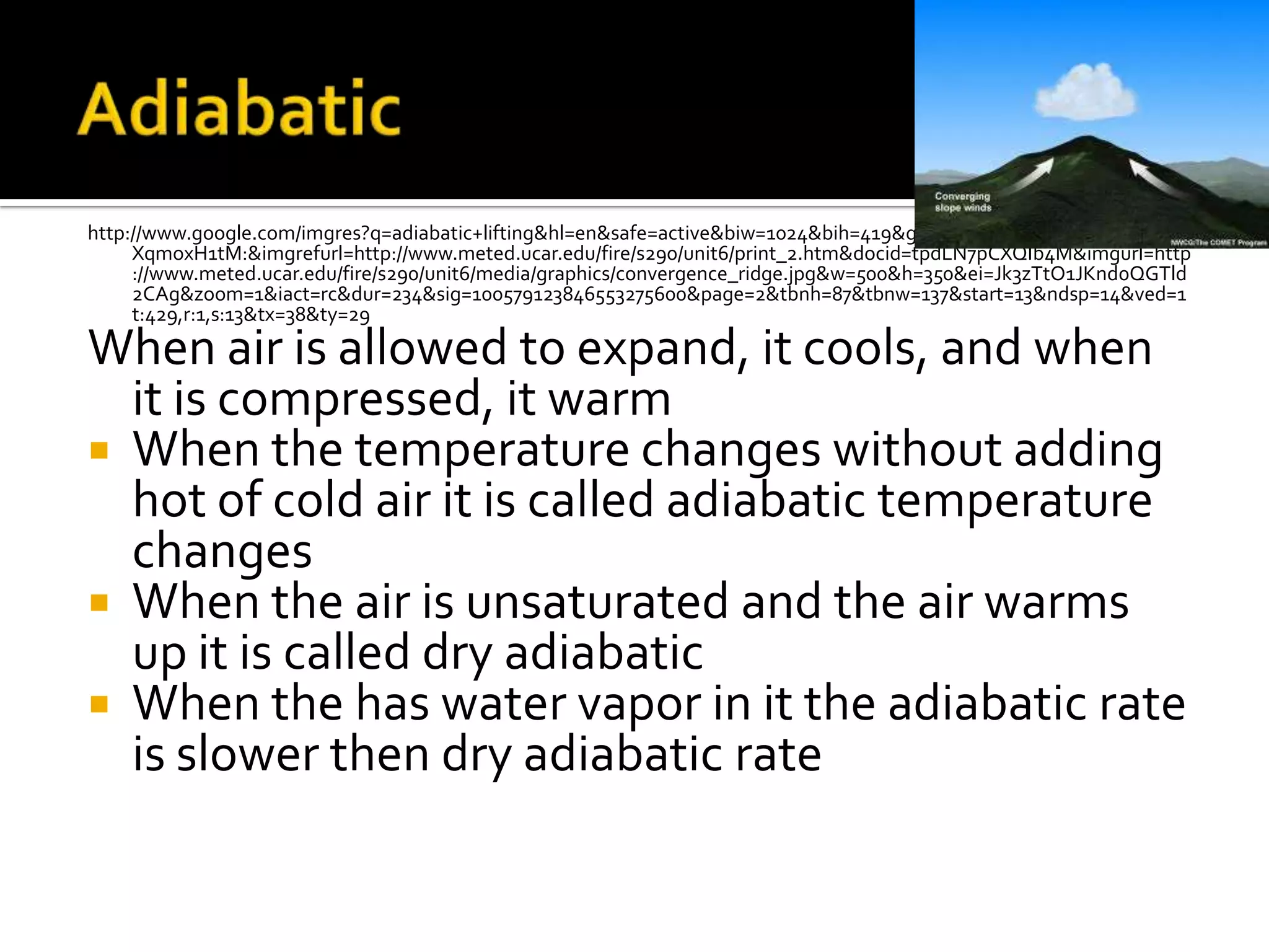
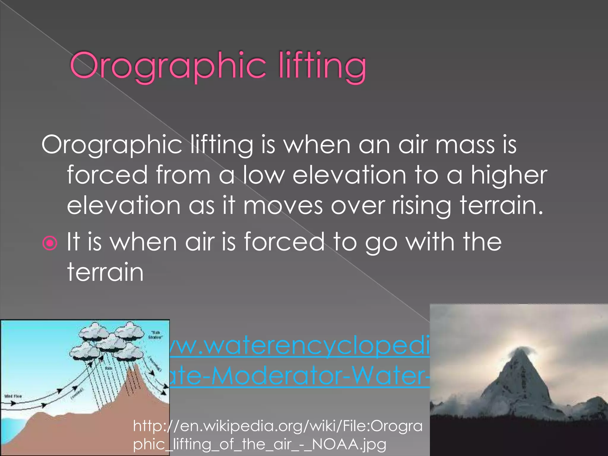
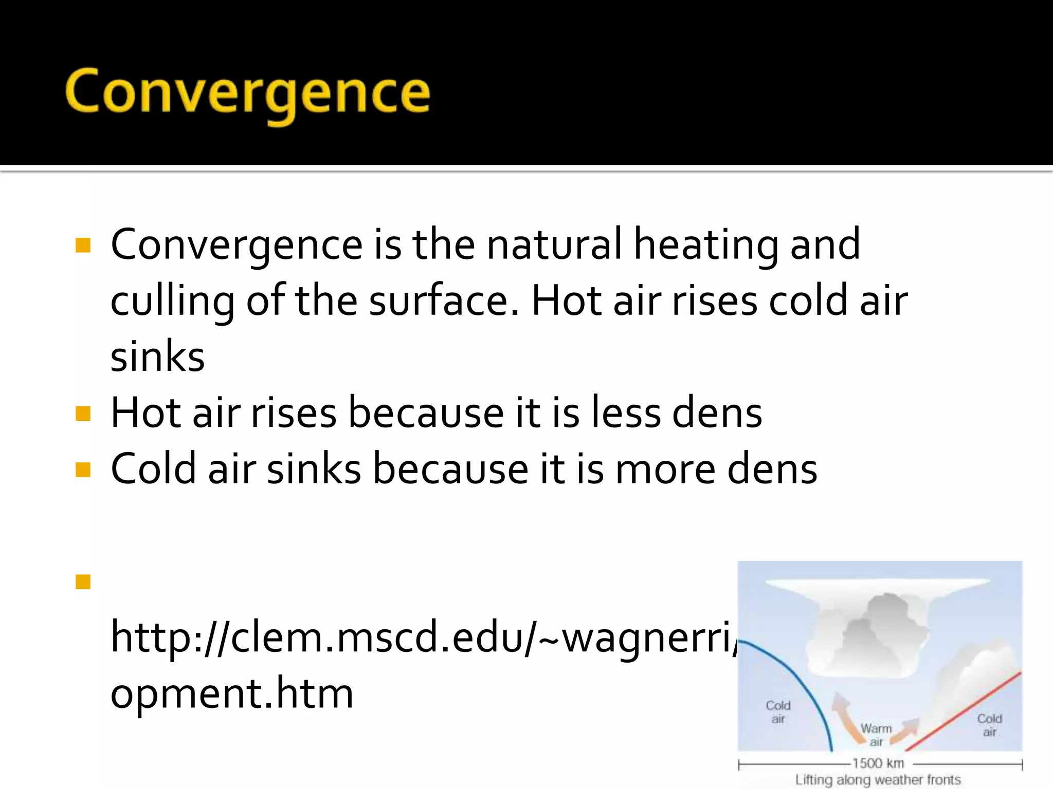
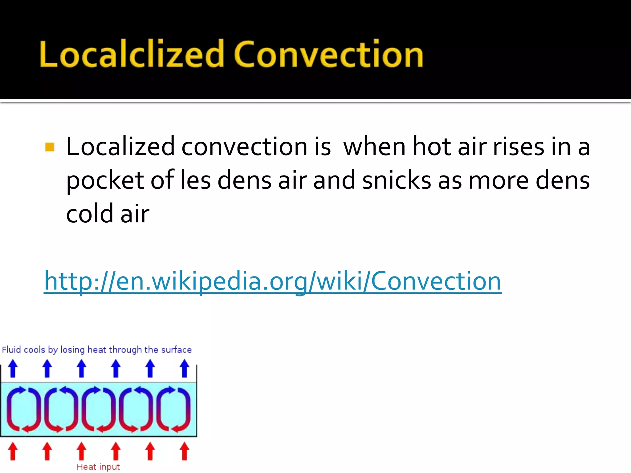
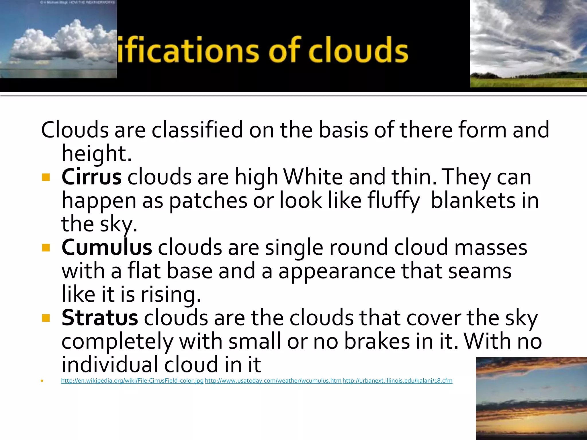
Christian Dumberth
http://www.google.com/imgres?q=adiabatic+lifting&hl=en&safe=active&biw=1024&bih=419&gbv=2&tbm=isch&tbnid=_ZLQk
     XqmoxH1tM:&imgrefurl=http://www.meted.ucar.edu/fire/s290/unit6/print_2.htm&docid=tpdLN7pCXQIb4M&imgurl=http
     ://www.meted.ucar.edu/fire/s290/unit6/media/graphics/convergence_ridge.jpg&w=500&h=350&ei=Jk3zTtO1JKnd0QGTld
     2CAg&zoom=1&iact=rc&dur=234&sig=100579123846553275600&page=2&tbnh=87&tbnw=137&start=13&ndsp=14&ved=1
     t:429,r:1,s:13&tx=38&ty=29

When air is allowed to expand, it cools, and when
  it is compressed, it warm
 When the temperature changes without adding
  hot of cold air it is called adiabatic temperature
  changes
 When the air is unsaturated and the air warms
  up it is called dry adiabatic
 When the has water vapor in it the adiabatic rate
  is slower then dry adiabatic rate
Orographic lifting is when an air mass is
  forced from a low elevation to a higher
  elevation as it moves over rising terrain.
 It is when air is forced to go with the
  terrain

 http://www.waterencyclopedia.com/Ce-
  Cr/Climate-Moderator-Water-as-a.html
       http://en.wikipedia.org/wiki/File:Orogra
       phic_lifting_of_the_air_-_NOAA.jpg
Front
 A front is a boundary between a cooling body
 mass of hot air and cold air. A frontal wedging is
 ware the cold air is in the front

http://www.windows2universe.org/earth/Atmospher
  e/tstorm/occl_front.html
  http://keithrogershome.com/Chap11Fronts.html
   Convergence is the natural heating and
    culling of the surface. Hot air rises cold air
    sinks
   Hot air rises because it is less dens
   Cold air sinks because it is more dens


    http://clem.mscd.edu/~wagnerri/CloudDevel
    opment.htm
   Localized convection is when hot air rises in a
    pocket of les dens air and snicks as more dens
    cold air

http://en.wikipedia.org/wiki/Convection
Stable air stays in its original position, wile
  unstable air rises
 the most stable conditions for the air is when
  air temperature actually increases with
  height it Is called a temperature inversion.

 http://www.airphotona.com/image.asp?imag
 eid=14226&catnum=0&keyword=&country=
 &state=&pagenum=556
 http://www.targetarea.net/var05.html
For condensation to happen the air must be
  saturated to make dew, fog, or clouds
 When air is saturated the water vapor
  condensates on to dust witch is called
  condensation nucli.
http://decorating.visitacasas.com/how-to-
  combat-condensation/
Clouds are classified on the basis of there form and
  height.
 Cirrus clouds are high White and thin. They can
  happen as patches or look like fluffy blankets in
  the sky.
 Cumulus clouds are single round cloud masses
  with a flat base and a appearance that seams
  like it is rising.
 Stratus clouds are the clouds that cover the sky
  completely with small or no brakes in it. With no

  individual cloud in it
    http://en.wikipedia.org/wiki/File:CirrusField-color.jpg http://www.usatoday.com/weather/wcumulus.htm http://urbanext.illinois.edu/kalani/18.cfm
   The high clouds are called cirrocumulus cloud
    and there are three clouds that make up the
    high cloud they are the cirrus, cirrocumulus,
    and cirrostratus clouds.
   It is 6000m in the air
   All high clouds are thin and white and often
    made of ice crystals

        http://eo.ucar.edu/kids/sky/clouds3.htm
   The middle clouds also known as the
    altocumulus cloud they can change there form in
    different conditions
   They are 2000, 6000 meters in the air
   They can be a Wight or gray with an infrequent
    light snow or drizzle mar accompany the clouds

http://www.bigbranch.net/middle%20clouds.htm
 There is three types of low clouds stratus,
  stratocumulus, and nimbostratus.
 The stratus cloud is a fog like layer that always cover
  the sky. When the cloud gets uneven it becomes an a
  stratocumulus cloud
 A nimbostratus cloud is the clouds that produce
  precipitation
    http://ed101.bu.edu/StudentDoc/current/ED101fa10/j
    enmks/stratus.html
    http://www.tariqweb.com/2011/03/04/stratocumulus-
    clouds/
    http://en.wikipedia.org/wiki/File:June_2005_dark_clo
    ud.jpg
   Clouds that don’t fit in the three height
    categories
   The clouds with vertical development are
    filed with unstable air and all of them are
    related to another.
   They can also produce rain


    http://www.wbsg.org/weather/weather_clou
    ds.asp
 It starts when the earth cools off rapidly bye
  radiation
http://www.scoutingny.com/?m=201008
   When the temperature is 4c snowflakes
    usually melt and continuo as rain drops
   When the temperature is -5c ice crystals join
    into larger clumps and form a snow flake.


                        http://www.shutterstock.com/pic-
                        47930068/stock-vector--glossy-icons-
                        representing-different-weather-symbol-sun-
                        clouds-rain-storm-snow-night.html
   Sleet is the fall of small particles of clear
    transparent ice.
   Glaze also known as freezing rain it happens
    when rain becomes 0c and when it hits a
    surface I turns into ice.
   Hail is produced in a cumulonimbus cloud it
    starts as a small ice pellets that grow by
    collecting super cooling water as they fall.

Moisture,clouds,and precipitation

  • 1.
  • 2.
    http://www.google.com/imgres?q=adiabatic+lifting&hl=en&safe=active&biw=1024&bih=419&gbv=2&tbm=isch&tbnid=_ZLQk XqmoxH1tM:&imgrefurl=http://www.meted.ucar.edu/fire/s290/unit6/print_2.htm&docid=tpdLN7pCXQIb4M&imgurl=http ://www.meted.ucar.edu/fire/s290/unit6/media/graphics/convergence_ridge.jpg&w=500&h=350&ei=Jk3zTtO1JKnd0QGTld 2CAg&zoom=1&iact=rc&dur=234&sig=100579123846553275600&page=2&tbnh=87&tbnw=137&start=13&ndsp=14&ved=1 t:429,r:1,s:13&tx=38&ty=29 When air is allowed to expand, it cools, and when it is compressed, it warm  When the temperature changes without adding hot of cold air it is called adiabatic temperature changes  When the air is unsaturated and the air warms up it is called dry adiabatic  When the has water vapor in it the adiabatic rate is slower then dry adiabatic rate
  • 3.
    Orographic lifting iswhen an air mass is forced from a low elevation to a higher elevation as it moves over rising terrain.  It is when air is forced to go with the terrain http://www.waterencyclopedia.com/Ce- Cr/Climate-Moderator-Water-as-a.html http://en.wikipedia.org/wiki/File:Orogra phic_lifting_of_the_air_-_NOAA.jpg
  • 4.
    Front  A frontis a boundary between a cooling body mass of hot air and cold air. A frontal wedging is ware the cold air is in the front http://www.windows2universe.org/earth/Atmospher e/tstorm/occl_front.html http://keithrogershome.com/Chap11Fronts.html
  • 5.
    Convergence is the natural heating and culling of the surface. Hot air rises cold air sinks  Hot air rises because it is less dens  Cold air sinks because it is more dens  http://clem.mscd.edu/~wagnerri/CloudDevel opment.htm
  • 6.
    Localized convection is when hot air rises in a pocket of les dens air and snicks as more dens cold air http://en.wikipedia.org/wiki/Convection
  • 7.
    Stable air staysin its original position, wile unstable air rises  the most stable conditions for the air is when air temperature actually increases with height it Is called a temperature inversion. http://www.airphotona.com/image.asp?imag eid=14226&catnum=0&keyword=&country= &state=&pagenum=556 http://www.targetarea.net/var05.html
  • 8.
    For condensation tohappen the air must be saturated to make dew, fog, or clouds  When air is saturated the water vapor condensates on to dust witch is called condensation nucli. http://decorating.visitacasas.com/how-to- combat-condensation/
  • 9.
    Clouds are classifiedon the basis of there form and height.  Cirrus clouds are high White and thin. They can happen as patches or look like fluffy blankets in the sky.  Cumulus clouds are single round cloud masses with a flat base and a appearance that seams like it is rising.  Stratus clouds are the clouds that cover the sky completely with small or no brakes in it. With no  individual cloud in it http://en.wikipedia.org/wiki/File:CirrusField-color.jpg http://www.usatoday.com/weather/wcumulus.htm http://urbanext.illinois.edu/kalani/18.cfm
  • 10.
    The high clouds are called cirrocumulus cloud and there are three clouds that make up the high cloud they are the cirrus, cirrocumulus, and cirrostratus clouds.  It is 6000m in the air  All high clouds are thin and white and often made of ice crystals  http://eo.ucar.edu/kids/sky/clouds3.htm
  • 11.
    The middle clouds also known as the altocumulus cloud they can change there form in different conditions  They are 2000, 6000 meters in the air  They can be a Wight or gray with an infrequent light snow or drizzle mar accompany the clouds http://www.bigbranch.net/middle%20clouds.htm
  • 12.
     There isthree types of low clouds stratus, stratocumulus, and nimbostratus.  The stratus cloud is a fog like layer that always cover the sky. When the cloud gets uneven it becomes an a stratocumulus cloud  A nimbostratus cloud is the clouds that produce precipitation http://ed101.bu.edu/StudentDoc/current/ED101fa10/j enmks/stratus.html http://www.tariqweb.com/2011/03/04/stratocumulus- clouds/ http://en.wikipedia.org/wiki/File:June_2005_dark_clo ud.jpg
  • 13.
    Clouds that don’t fit in the three height categories  The clouds with vertical development are filed with unstable air and all of them are related to another.  They can also produce rain http://www.wbsg.org/weather/weather_clou ds.asp
  • 14.
     It startswhen the earth cools off rapidly bye radiation http://www.scoutingny.com/?m=201008
  • 15.
    When the temperature is 4c snowflakes usually melt and continuo as rain drops  When the temperature is -5c ice crystals join into larger clumps and form a snow flake. http://www.shutterstock.com/pic- 47930068/stock-vector--glossy-icons- representing-different-weather-symbol-sun- clouds-rain-storm-snow-night.html
  • 16.
    Sleet is the fall of small particles of clear transparent ice.  Glaze also known as freezing rain it happens when rain becomes 0c and when it hits a surface I turns into ice.  Hail is produced in a cumulonimbus cloud it starts as a small ice pellets that grow by collecting super cooling water as they fall.