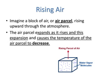
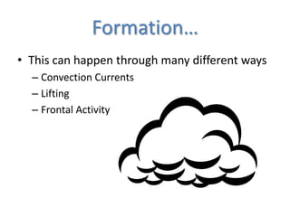
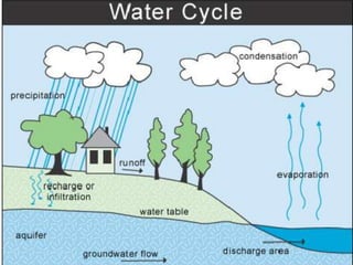
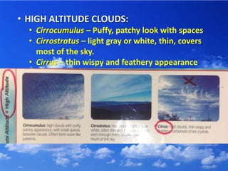
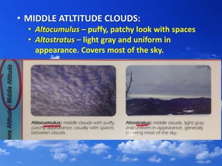
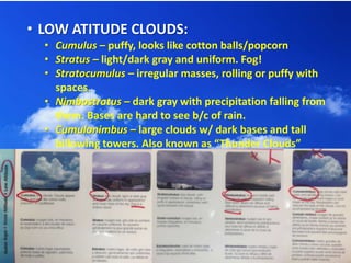
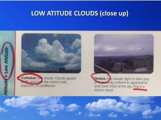
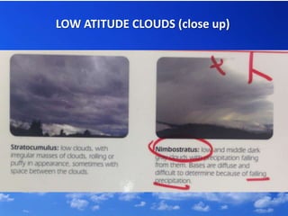
Cloud formation
Rising Air
• Imagine a block of air, or air parcel, rising
upward through the atmosphere.
• The air parcel expands as it rises and this
expansion and causes the temperature of the
air parcel to decrease.
Condensation
• As the parcel rises the air is cooler.
• Cold air holds less water than hot air,
therefore, the water vapor gets closer
together, and cloud droplets begin forming.
CONDENSATION
Water vapor combing to
make water droplets
Formation…
• This can happen through many different ways
– Convection Currents
– Lifting
– Frontal Activity
Convection Currents
Lifting (help of mountains)
Frontal Activity (Warm & Cold)
• There are many different types of clouds.
They are classified as:
• High Altitude
• Middle Altitude
• Low
• HIGH ALTITUDE CLOUDS:
• Cirrocumulus – Puffy, patchy look with spaces
• Cirrostratus – light gray or white, thin, covers
most of the sky.
• Cirrus – thin wispy and feathery appearance
• MIDDLE ATLTITUDE CLOUDS:
• Altocumulus – puffy, patchy look with spaces
• Altostratus – light gray and uniform in
appearance. Covers most of the sky.
• LOW ATITUDE CLOUDS:
• Cumulus – puffy, looks like cotton balls/popcorn
• Stratus – light/dark gray and uniform. Fog!
• Stratocumulus – irregular masses, rolling or puffy with
spaces.
• Nimbostratus – dark gray with precipitation falling from
them. Bases are hard to see b/c of rain.
• Cumulonimbus – large clouds w/ dark bases and tall
billowing towers. Also known as “Thunder Clouds”
LOW ATITUDE CLOUDS (close up)
LOW ATITUDE CLOUDS (close ups)
What questions do you have about cloud formation or types of clouds?

Cloud formation - How clouds form and different types of clouds

  • 1.
  • 3.
    Rising Air • Imaginea block of air, or air parcel, rising upward through the atmosphere. • The air parcel expands as it rises and this expansion and causes the temperature of the air parcel to decrease.
  • 4.
    Condensation • As theparcel rises the air is cooler. • Cold air holds less water than hot air, therefore, the water vapor gets closer together, and cloud droplets begin forming. CONDENSATION Water vapor combing to make water droplets
  • 5.
    Formation… • This canhappen through many different ways – Convection Currents – Lifting – Frontal Activity
  • 6.
  • 7.
    Lifting (help ofmountains)
  • 8.
  • 10.
    • There aremany different types of clouds. They are classified as: • High Altitude • Middle Altitude • Low
  • 11.
    • HIGH ALTITUDECLOUDS: • Cirrocumulus – Puffy, patchy look with spaces • Cirrostratus – light gray or white, thin, covers most of the sky. • Cirrus – thin wispy and feathery appearance
  • 12.
    • MIDDLE ATLTITUDECLOUDS: • Altocumulus – puffy, patchy look with spaces • Altostratus – light gray and uniform in appearance. Covers most of the sky.
  • 13.
    • LOW ATITUDECLOUDS: • Cumulus – puffy, looks like cotton balls/popcorn • Stratus – light/dark gray and uniform. Fog! • Stratocumulus – irregular masses, rolling or puffy with spaces. • Nimbostratus – dark gray with precipitation falling from them. Bases are hard to see b/c of rain. • Cumulonimbus – large clouds w/ dark bases and tall billowing towers. Also known as “Thunder Clouds”
  • 14.
  • 15.
  • 16.
    LOW ATITUDE CLOUDS(close ups)
  • 17.
    What questions doyou have about cloud formation or types of clouds?