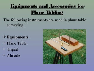
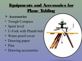
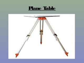
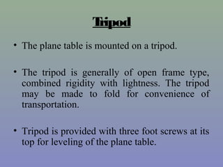
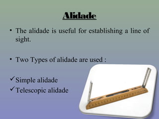
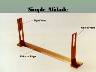
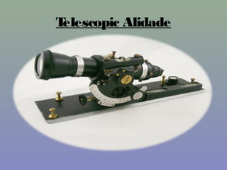
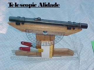
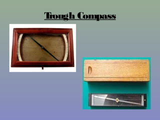
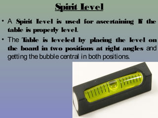
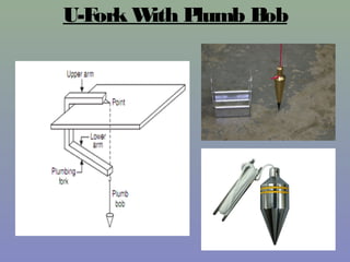
Government Polytechnic
Kashipur
Presentation Topic :- PLANE TABLE SURVEYING
PREPARED BY :- SHUBHAM SIROHI (160092500)
Agricultural Engg. 2nd
Year
Govt. Polytechnic College, KASHIPUR
GUIDED BY:
MR. SURENDER SINGH NEGI
SUBJECT :- SURVEYING AND LEVELLING
Plane Table Surveying
• Plane Table Surveying is a graphical method
of survey in which the field observations and
plotting aredonesimultaneously.
• It is simple and cheaper than theodolite
survey. It ismost suitablefor small scalemaps.
• The plan is drawn by the surveyor in the field,
while the area to be surveyed is before his eyes.
Therefore, there is no possibility of omitting the
necessary measurements.
Equipments and Accessories for
Plane Tabling
The following instruments are used in plane table
surveying.
Equipments
• Plane Table
• Tripod
• Alidade
Equipments and Accessories for
Plane Tabling
 Accessories
• Trough Compass
• Spirit level
• U-Fork with Plumb bob
• Water proof cover
• Drawing paper
• Pins
• Drawing accessories
Plane Table
Tripod
• The plane table is mounted on a tripod.
• The tripod is generally of open frame type,
combined rigidity with lightness. The tripod
may be made to fold for convenience of
transportation.
• Tripod is provided with three foot screws at its
top for leveling of the plane table.
Alidade
• The alidade is useful for establishing a line of
sight.
• Two Types of alidade are used :
Simple alidade
Telescopic alidade
Simple Alidade
Sight Vane
Fiducial Edge
Object Vane
Telescopic Alidade
Telescopic Alidade
Accessories
Trough Compass
• The trough compass is required for drawing
the line showing magnetic meridian on the
paper. It is used to orient the table to the
magnetic meridian.
• When the freely suspended needle shows 00
at each end, a line is drawn on the drawing
paper which representsthemagnetic north.
Trough Compass
Spirit Level
• A Spirit Level is used for ascertaining If the
table is properly level.
• The Table is leveled by placing the level on
the board in two positions at right angles and
getting thebubblecentral in both positions.
U-Fork With Plumb Bob
WaterProof Cover
• An umbrella is used to protect the drawing paper
from rain.
Drawing Paper
• Drawing paper is used for plotting the ground
details.
Advantages and Disadvantages of
Plane Table Surveying
Advantages
• The plan is drawn by the surveyor himself
while the area to be surveyed is before his eyes.
Therefore, there is no possibility of omitting
the necessary measurements.
• The surveyor Can compare the plotted work
with theactual featuresof thearea.
Advantages
• It is simple and cheaper than the theodolite
survey.
• It ismost suitable forsmall scale maps.
• No great skill is required to produce a satisfactory
map and work may beentrusted to asubordinate.
• It is useful in magnetic areas where compass may
not beused.
• The mistakes in writing field books are
eliminated.
Disadvantages (Limitations)
• It is not intended for very accurate work.
• It is not suitable in monsoon.
• It is essentially a tropical instrument.
• Due to heaviness, it is inconvenient to transport.
• Since there are so many accessories, there is
likelihood of them being lost.
Principle Of Plane Table Survey
• The principle of plane tabling is parallelism
means,
• Principle: “All the rays drawn through
various details should pass through the
survey station.”
• The Position of plane table at each station must
be identical, i.e. at each survey station the table
must be oriented in the direction of magnetic
north.
Method Of Setting Up The Plane
Table
Threeprocessesareinvolved in setting up the
planetableover thestation.
• Leveling
• Centering
• Orientation
Levelling
Centering
Levelling and Centering
• The Table should be set up at convenient
height for working on the board, say about 1
m. The legs of Tripod should be spread well
apart and firmly into theground.
Leveling and Centering
• The table should be so placed over the
station on the ground that the point plotted
on the sheet corresponding to the station
occupied should be exactly over the station
on the ground. The operation is known as
centering the plane table. It is done by U-fork
and plumb bob.
• For leveling the table ordinary spirit level may be
used. The table is leveled by placing the level on
the board in two positions at right angles and
getting thebubblecentral in both directions.
Orientation
• The Process by which the positions occupied by
the board at various survey stations are kept
parallel is known as the orientation. Thus, when
a plane table is properly oriented, the lines on the
board are parallel to the lines on ground which
they represent.
• There are two methods of orientation:
• By magnetic needle
• By back sighting
Orientation
Orientation
By Magnetic Needle
• In this method, the magnetic north is drawn on
paper at a particular station. At the next station,
the trough compass is placed along the line of
magnetic north and the table is turned in such a way
that the ends of magnetic needle are opposite to zeros
of the scale. The board is then fixed in position by
clamps. Thismethod isinaccuratein thesincethat the
results are likely to be affected by the local
attraction.
By Back Sighting
• A= First survey station.
• B= Second survey station.
• Suppose a line is drawn from station A on paper as ab,
representing lineAB on ground.
• The table is turned till the line of sight bisects the ranging
rod at A. Theboard isthen clamped in thisposition.
• This method is better than the previous one and it gives
perfect orientation.
THANK YOU

Plane table surveying by Paritosh Singh Vardhan

  • 1.
    Government Polytechnic Kashipur Presentation Topic:- PLANE TABLE SURVEYING PREPARED BY :- SHUBHAM SIROHI (160092500) Agricultural Engg. 2nd Year Govt. Polytechnic College, KASHIPUR GUIDED BY: MR. SURENDER SINGH NEGI SUBJECT :- SURVEYING AND LEVELLING
  • 2.
    Plane Table Surveying •Plane Table Surveying is a graphical method of survey in which the field observations and plotting aredonesimultaneously. • It is simple and cheaper than theodolite survey. It ismost suitablefor small scalemaps. • The plan is drawn by the surveyor in the field, while the area to be surveyed is before his eyes. Therefore, there is no possibility of omitting the necessary measurements.
  • 3.
    Equipments and Accessoriesfor Plane Tabling The following instruments are used in plane table surveying. Equipments • Plane Table • Tripod • Alidade
  • 4.
    Equipments and Accessoriesfor Plane Tabling  Accessories • Trough Compass • Spirit level • U-Fork with Plumb bob • Water proof cover • Drawing paper • Pins • Drawing accessories
  • 5.
  • 6.
    Tripod • The planetable is mounted on a tripod. • The tripod is generally of open frame type, combined rigidity with lightness. The tripod may be made to fold for convenience of transportation. • Tripod is provided with three foot screws at its top for leveling of the plane table.
  • 7.
    Alidade • The alidadeis useful for establishing a line of sight. • Two Types of alidade are used : Simple alidade Telescopic alidade
  • 8.
  • 9.
  • 10.
  • 11.
    Accessories Trough Compass • Thetrough compass is required for drawing the line showing magnetic meridian on the paper. It is used to orient the table to the magnetic meridian. • When the freely suspended needle shows 00 at each end, a line is drawn on the drawing paper which representsthemagnetic north.
  • 12.
  • 13.
    Spirit Level • ASpirit Level is used for ascertaining If the table is properly level. • The Table is leveled by placing the level on the board in two positions at right angles and getting thebubblecentral in both positions.
  • 14.
  • 15.
    WaterProof Cover • Anumbrella is used to protect the drawing paper from rain.
  • 16.
    Drawing Paper • Drawingpaper is used for plotting the ground details.
  • 17.
    Advantages and Disadvantagesof Plane Table Surveying Advantages • The plan is drawn by the surveyor himself while the area to be surveyed is before his eyes. Therefore, there is no possibility of omitting the necessary measurements. • The surveyor Can compare the plotted work with theactual featuresof thearea.
  • 18.
    Advantages • It issimple and cheaper than the theodolite survey. • It ismost suitable forsmall scale maps. • No great skill is required to produce a satisfactory map and work may beentrusted to asubordinate. • It is useful in magnetic areas where compass may not beused. • The mistakes in writing field books are eliminated.
  • 19.
    Disadvantages (Limitations) • Itis not intended for very accurate work. • It is not suitable in monsoon. • It is essentially a tropical instrument. • Due to heaviness, it is inconvenient to transport. • Since there are so many accessories, there is likelihood of them being lost.
  • 20.
    Principle Of PlaneTable Survey • The principle of plane tabling is parallelism means, • Principle: “All the rays drawn through various details should pass through the survey station.” • The Position of plane table at each station must be identical, i.e. at each survey station the table must be oriented in the direction of magnetic north.
  • 21.
    Method Of SettingUp The Plane Table Threeprocessesareinvolved in setting up the planetableover thestation. • Leveling • Centering • Orientation
  • 22.
  • 23.
  • 24.
    Levelling and Centering •The Table should be set up at convenient height for working on the board, say about 1 m. The legs of Tripod should be spread well apart and firmly into theground.
  • 25.
    Leveling and Centering •The table should be so placed over the station on the ground that the point plotted on the sheet corresponding to the station occupied should be exactly over the station on the ground. The operation is known as centering the plane table. It is done by U-fork and plumb bob. • For leveling the table ordinary spirit level may be used. The table is leveled by placing the level on the board in two positions at right angles and getting thebubblecentral in both directions.
  • 26.
    Orientation • The Processby which the positions occupied by the board at various survey stations are kept parallel is known as the orientation. Thus, when a plane table is properly oriented, the lines on the board are parallel to the lines on ground which they represent. • There are two methods of orientation: • By magnetic needle • By back sighting
  • 27.
  • 28.
  • 29.
    By Magnetic Needle •In this method, the magnetic north is drawn on paper at a particular station. At the next station, the trough compass is placed along the line of magnetic north and the table is turned in such a way that the ends of magnetic needle are opposite to zeros of the scale. The board is then fixed in position by clamps. Thismethod isinaccuratein thesincethat the results are likely to be affected by the local attraction.
  • 30.
    By Back Sighting •A= First survey station. • B= Second survey station. • Suppose a line is drawn from station A on paper as ab, representing lineAB on ground. • The table is turned till the line of sight bisects the ranging rod at A. Theboard isthen clamped in thisposition. • This method is better than the previous one and it gives perfect orientation.
  • 31.