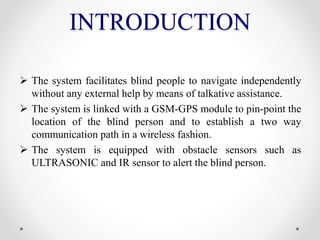
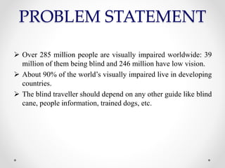
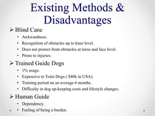
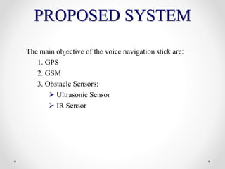
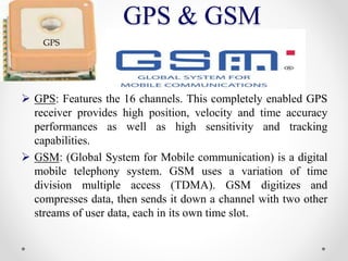
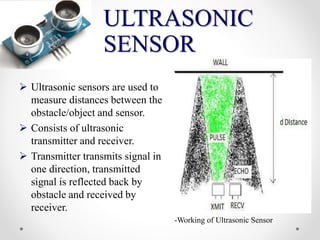
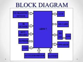
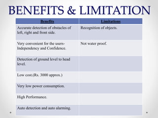
The Oxford College of Engineering
Department of ISE.
Seminar on:
“Location Finding for Blind People
Using Voice Navigation Stick”
Presented By:
SANJANA V
1OX12IS115
AGENDA
 INTRODUCTION
 PROBLEM STATEMENT
 EXISTING METHODS
 PROPOSED SYSTEM
 BLOCK DIAGRAM
 BENEFITS & LIMITATIONS
 REFERENCES
INTRODUCTION
 The system facilitates blind people to navigate independently
without any external help by means of talkative assistance.
 The system is linked with a GSM-GPS module to pin-point the
location of the blind person and to establish a two way
communication path in a wireless fashion.
 The system is equipped with obstacle sensors such as
ULTRASONIC and IR sensor to alert the blind person.
PROBLEM STATEMENT
 Over 285 million people are visually impaired worldwide: 39
million of them being blind and 246 million have low vision.
 About 90% of the world’s visually impaired live in developing
countries.
 The blind traveller should depend on any other guide like blind
cane, people information, trained dogs, etc.
Existing Methods &
Disadvantages
 Blind Cane
• Awkwardness.
• Recognition of obstacles up to knee level.
• Does not protect from obstacles at torso and face level.
• Prone to injuries.
 Trained Guide Dogs
• 1% usage.
• Expensive to Train Dogs ( $40k in USA).
• Training period on an average 6 months.
• Difficulty in dog up-keeping costs and lifestyle changes.
 Human Guide
• Dependency.
• Feeling of being a burden.
PROPOSED SYSTEM
The main objective of the voice navigation stick are:
1. GPS
2. GSM
3. Obstacle Sensors:
 Ultrasonic Sensor
 IR Sensor
GPS & GSM
 GPS: Features the 16 channels. This completely enabled GPS
receiver provides high position, velocity and time accuracy
performances as well as high sensitivity and tracking
capabilities.
 GSM: (Global System for Mobile communication) is a digital
mobile telephony system. GSM uses a variation of time
division multiple access (TDMA). GSM digitizes and
compresses data, then sends it down a channel with two other
streams of user data, each in its own time slot.
GPS
ULTRASONIC
SENSOR
 Ultrasonic sensors are used to
measure distances between the
obstacle/object and sensor.
 Consists of ultrasonic
transmitter and receiver.
 Transmitter transmits signal in
one direction, transmitted
signal is reflected back by
obstacle and received by
receiver.
-Working of Ultrasonic Sensor
BLOCK DIAGRAM
BENEFITS & LIMITATION
Benefits Limitations
Accurate detection of obstacles of
left, right and front side.
Recognition of objects.
Very convenient for the users-
Independency and Confidence.
Not water proof.
Detection of ground level to head
level.
Low cost.(Rs. 3000 approx.)
Very low power consumption.
High Performance.
Auto detection and auto alarming.
REFERENCES
 S. Sai Santhosh, T. Sasiprabha, R. Jeberson,. "BLI – NAV Embedded
Navigation System for Blind People." IEEE, 277-282, 2010:.
 A. R. García, R. Fonseca. A. Durán. "Electronic long cane for locomotion
improving on visual impaired people." IEEE, pp.58-61, 2011
 Alshbatat, Abdel Ilah Nour. "Automated Mobility and Orientation System for
Blind or Partially." INTERNATIONAL JOURNAL ON SMART SENSING
AND INTELLIGENT SYSTEMS, 568-582, 2013.
 Mahdi Safaa A., Muhsin Asaad H. and Al-Mosawi Ali I. "Using Ultrasonic
Sensor for Blind and Deaf persons Combines Voice." International Science
Congress Association, 50-52, 2012
 Harshad Girish Lele, Viten Vilas Lonkar, Varun Vasant Marathe, Mrunmayi
Mohan Modak. "electronic path guidance for visually impaired people." The
International Journal Of Engineering And Science (IJES), 09-14, 2013.
 K. Steed-Terry, “Integrating GIS and the Global Positioning System,” 2nd ed.
ESRI inc. pp.1–12, 2001.
 A. Hub and B. Schmitz, “Addition of RFID-Based Initialization and Object
Recognition to the Navigation System TANIA,” Visualization and Interactive
Systems Group, Stuttgart, 2009.
QUESTIONS
THANK YOU

Location Finding for blind People Using Voice Navigation Stick Seminar

  • 1.
    The Oxford Collegeof Engineering Department of ISE. Seminar on: “Location Finding for Blind People Using Voice Navigation Stick” Presented By: SANJANA V 1OX12IS115
  • 2.
    AGENDA  INTRODUCTION  PROBLEMSTATEMENT  EXISTING METHODS  PROPOSED SYSTEM  BLOCK DIAGRAM  BENEFITS & LIMITATIONS  REFERENCES
  • 3.
    INTRODUCTION  The systemfacilitates blind people to navigate independently without any external help by means of talkative assistance.  The system is linked with a GSM-GPS module to pin-point the location of the blind person and to establish a two way communication path in a wireless fashion.  The system is equipped with obstacle sensors such as ULTRASONIC and IR sensor to alert the blind person.
  • 4.
    PROBLEM STATEMENT  Over285 million people are visually impaired worldwide: 39 million of them being blind and 246 million have low vision.  About 90% of the world’s visually impaired live in developing countries.  The blind traveller should depend on any other guide like blind cane, people information, trained dogs, etc.
  • 5.
    Existing Methods & Disadvantages Blind Cane • Awkwardness. • Recognition of obstacles up to knee level. • Does not protect from obstacles at torso and face level. • Prone to injuries.  Trained Guide Dogs • 1% usage. • Expensive to Train Dogs ( $40k in USA). • Training period on an average 6 months. • Difficulty in dog up-keeping costs and lifestyle changes.  Human Guide • Dependency. • Feeling of being a burden.
  • 6.
    PROPOSED SYSTEM The mainobjective of the voice navigation stick are: 1. GPS 2. GSM 3. Obstacle Sensors:  Ultrasonic Sensor  IR Sensor
  • 7.
    GPS & GSM GPS: Features the 16 channels. This completely enabled GPS receiver provides high position, velocity and time accuracy performances as well as high sensitivity and tracking capabilities.  GSM: (Global System for Mobile communication) is a digital mobile telephony system. GSM uses a variation of time division multiple access (TDMA). GSM digitizes and compresses data, then sends it down a channel with two other streams of user data, each in its own time slot. GPS
  • 8.
    ULTRASONIC SENSOR  Ultrasonic sensorsare used to measure distances between the obstacle/object and sensor.  Consists of ultrasonic transmitter and receiver.  Transmitter transmits signal in one direction, transmitted signal is reflected back by obstacle and received by receiver. -Working of Ultrasonic Sensor
  • 9.
  • 10.
    BENEFITS & LIMITATION BenefitsLimitations Accurate detection of obstacles of left, right and front side. Recognition of objects. Very convenient for the users- Independency and Confidence. Not water proof. Detection of ground level to head level. Low cost.(Rs. 3000 approx.) Very low power consumption. High Performance. Auto detection and auto alarming.
  • 11.
    REFERENCES  S. SaiSanthosh, T. Sasiprabha, R. Jeberson,. "BLI – NAV Embedded Navigation System for Blind People." IEEE, 277-282, 2010:.  A. R. García, R. Fonseca. A. Durán. "Electronic long cane for locomotion improving on visual impaired people." IEEE, pp.58-61, 2011  Alshbatat, Abdel Ilah Nour. "Automated Mobility and Orientation System for Blind or Partially." INTERNATIONAL JOURNAL ON SMART SENSING AND INTELLIGENT SYSTEMS, 568-582, 2013.  Mahdi Safaa A., Muhsin Asaad H. and Al-Mosawi Ali I. "Using Ultrasonic Sensor for Blind and Deaf persons Combines Voice." International Science Congress Association, 50-52, 2012  Harshad Girish Lele, Viten Vilas Lonkar, Varun Vasant Marathe, Mrunmayi Mohan Modak. "electronic path guidance for visually impaired people." The International Journal Of Engineering And Science (IJES), 09-14, 2013.  K. Steed-Terry, “Integrating GIS and the Global Positioning System,” 2nd ed. ESRI inc. pp.1–12, 2001.  A. Hub and B. Schmitz, “Addition of RFID-Based Initialization and Object Recognition to the Navigation System TANIA,” Visualization and Interactive Systems Group, Stuttgart, 2009.
  • 12.
  • 13.