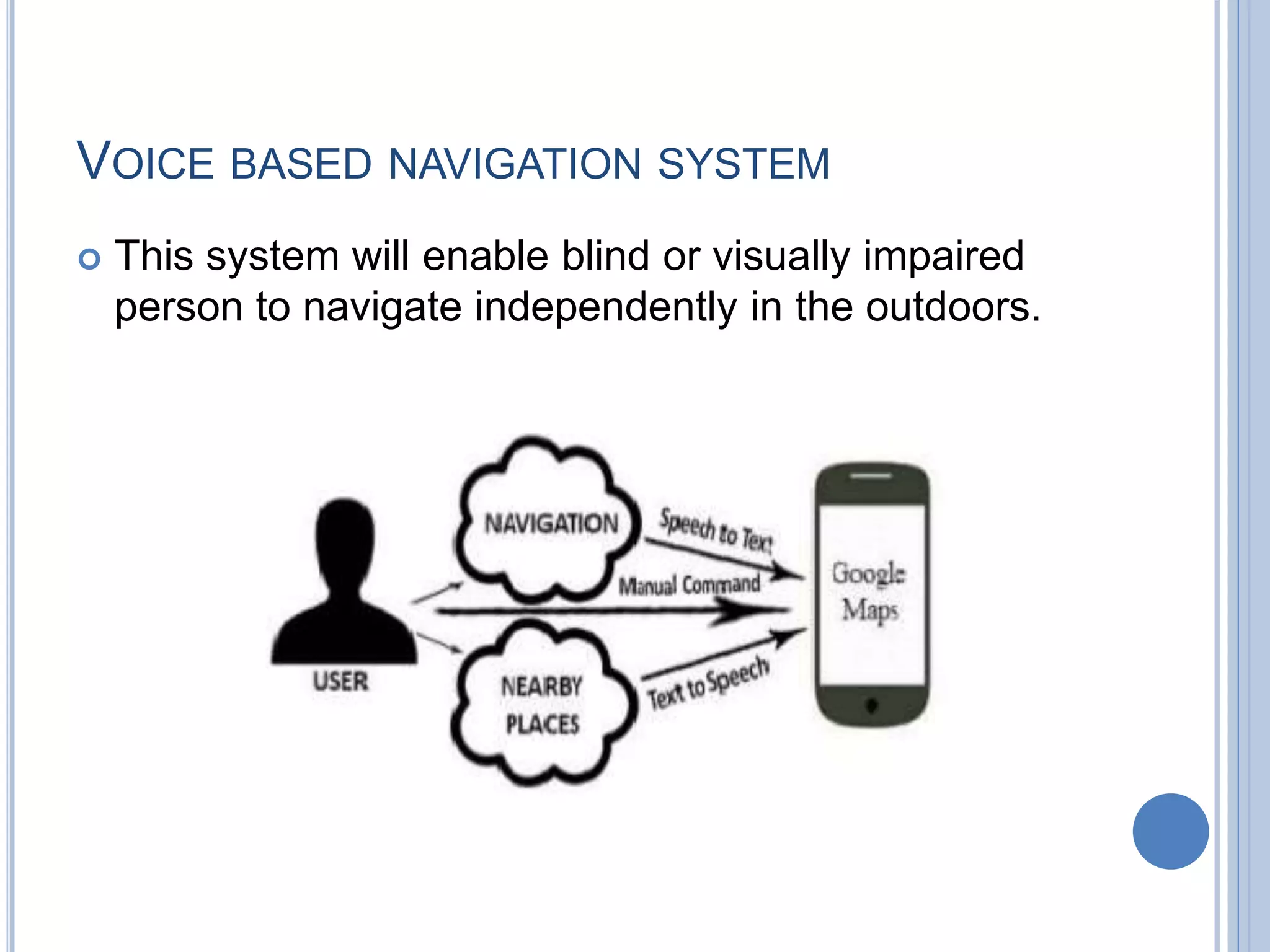
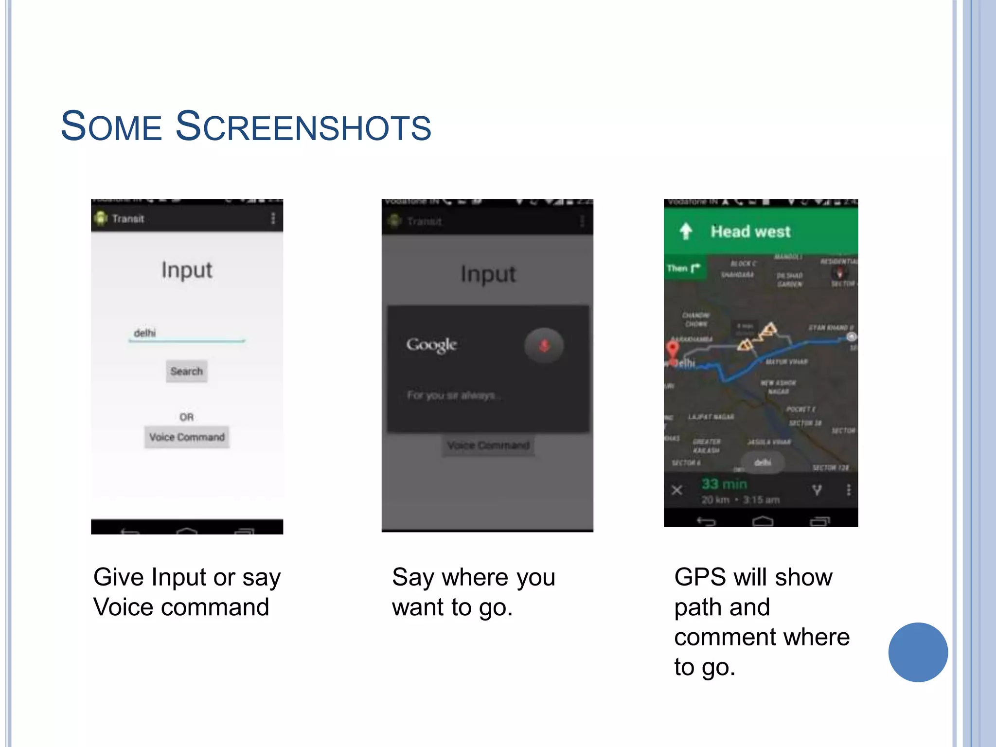
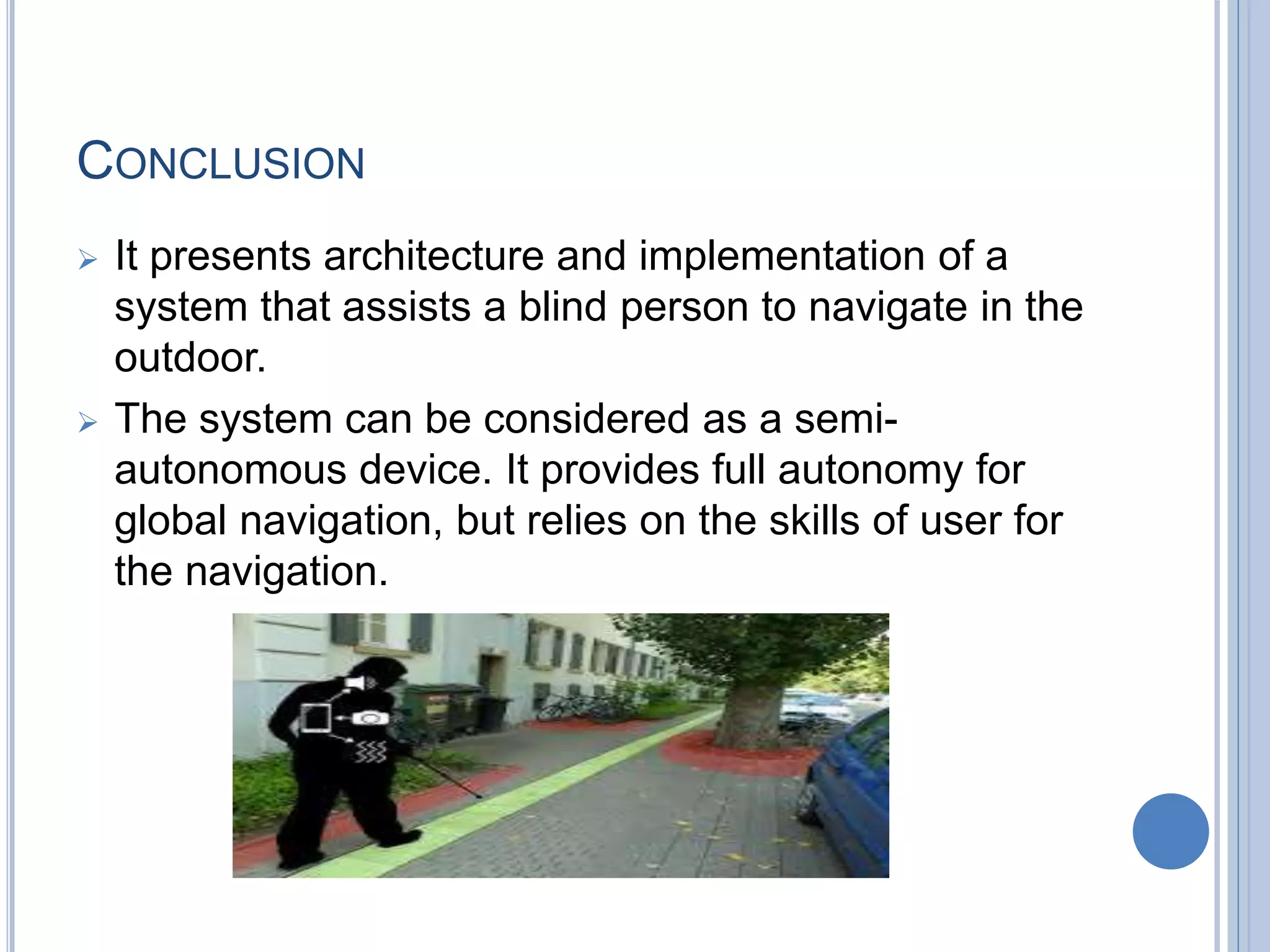
CAMPUS NAVIGATION AND IDENTIFYING
CURRENT LOCATION THROUGH ANDROID
DEVICE TO GUIDE BLIND PEOPLE
Presented by, Guided by,
Akanksha Kohale Prof.Pravin Rathod
(E-41)
OVERVIEW
 Objective
 Introduction
 Existing System
 Voice Based Navigation System
i)Software and Hardware requirements.
ii)System Architecture
 Conclusion
OBJECTIVE
 To guide blind people with voice based Navigation
system using Android Phone.
 To develop innovative and cost effective guide
system for blind people.
INTRODUCTION
 Blindness –A visual impairment.
 Help of other people for daily routine is very
demanding.
 Technological solutions introduced for this
problem.
 Robot Dog (GPS based+Object Avoidance Technology).
 GIS(Geographic Information System).
EXISTING SYSTEM
(GEOGRAPHICAL INFORMATION SYSTEM)
 GIS-Merging of cartography, statistical analysis,
and database technology.
 Finds near ROUTE or branch.
 A system designed to capture, store, manipulate,
analyze, manage, and present all types of
geographically referenced data.
 A framework to obtain information.
 Steps:
1. Enter your postcode.
2. Enter Town or City.
3. Press SEARCH.
MORE ABOUT GIS..
 Identifies location & navigates you to the required Place or
ROUTE.
 Get turn-by-turn directions to the required Place or
ROUTE.
 Utilized to view and handle data about geographic
locations and spatial correlations among others.
DISADVANTAGES OF GIS
 Complex mapping technology.
 No wrong root indication.
 While using GPS, it doesn’t identify the current
location through voice.
So,
Voice based Navigation System is the solution for
this.
VOICE BASED NAVIGATION SYSTEM
 This system will enable blind or visually impaired
person to navigate independently in the outdoors.
HARDWARE REQUIREMENTS
 Smart Phone with Android 4.0 or higher.
 Screen Resolution of at least 800X600 pixels is
required for proper and complete view of screens.
 An inbuilt microphone is needed for the user to
speak the commands and text
 Earphones with an inbuilt microphone suits the
system best.
SOFTWARE REQUIREMENTS
 A working internet connection.
 Google maps should be installed along with Google
voice search.
 At least 512MB RAM and 10MB space on phone
memory.
 The system uses:
 TTS (Text-to-Speech) .
 Google Map API.
 Microphones.
 Microcontroller.
 Electronic Path Guidance.
 Ultrasonic waist belt.
DETAILS
 TTS(Text-To-Speech):
Provides a navigation service through voice.
 Google Map API:
To get direction and map of destination.
 Microphones:
The blind gives the input about the place he has
to reach using microphones and the voice
recognition system recognizes it.
 Microcontroller:
1.It analyzes input given by user.
2.Controlling device of system.
 Electronic Path Guidance:
Help to move in an unfamiliar place independently
and with the same simplicity as they are in familiar
surroundings(Using Radio Frequency).
 Ultrasonic Waist Belt:
1.Consists of ultrasonic distance sensor.
2.It detects obstacles in the path of blind ,senses
obstacles.
3. Information is passed to the microcontroller
which alerts the user through voice circuit in case
of any obstacles in that direction, and helps the user to
avoid obstacles in its way.
SYSTEM ARCHITECTURE
 The system gets the sources as input from the user
as command then it gets the second input which is
the destination.
 From the given source and destination the map is
obtained by the use of GPS.
 The person starts walking from his/her source to
the destination.
 When the person starts walking the direction of
walking will be spoken out in the form of command.
 For finding the route map the route tracker map is
used.
 For the speaking command the command guided
system is used.
 Even the wrong way indication is made by the use
GPS.
 This GPS provides the location and time information
in all weather, anywhere on Earth.
 In this way blind person goes to required destination
with the help of voice based navigation system
happily!!
DIAGRAM SHOWING EXACT PROCEDURE
SOME SCREENSHOTS
Give Input or say
Voice command
Say where you
want to go.
GPS will show
path and
comment where
to go.
ADVANTAGES
 Space-based satellite navigation system.
 Provides location and time information in all
weather, anywhere on or near the Earth.
 If we enter into wrong root then automatic wrong
root indication will give by voice. If we are at near
then automatic nearest place indication will give by
voice.
 To identify the current location using GPS
connection in the way of voice guided system.
CONCLUSION
 It presents architecture and implementation of a
system that assists a blind person to navigate in the
outdoor.
 The system can be considered as a semi-
autonomous device. It provides full autonomy for
global navigation, but relies on the skills of user for
the navigation.
THANK YOU!

Campus navigation and identifying current location through android

  • 1.
    CAMPUS NAVIGATION ANDIDENTIFYING CURRENT LOCATION THROUGH ANDROID DEVICE TO GUIDE BLIND PEOPLE Presented by, Guided by, Akanksha Kohale Prof.Pravin Rathod (E-41)
  • 2.
    OVERVIEW  Objective  Introduction Existing System  Voice Based Navigation System i)Software and Hardware requirements. ii)System Architecture  Conclusion
  • 3.
    OBJECTIVE  To guideblind people with voice based Navigation system using Android Phone.  To develop innovative and cost effective guide system for blind people.
  • 4.
    INTRODUCTION  Blindness –Avisual impairment.  Help of other people for daily routine is very demanding.  Technological solutions introduced for this problem.  Robot Dog (GPS based+Object Avoidance Technology).  GIS(Geographic Information System).
  • 5.
    EXISTING SYSTEM (GEOGRAPHICAL INFORMATIONSYSTEM)  GIS-Merging of cartography, statistical analysis, and database technology.  Finds near ROUTE or branch.  A system designed to capture, store, manipulate, analyze, manage, and present all types of geographically referenced data.  A framework to obtain information.  Steps: 1. Enter your postcode. 2. Enter Town or City. 3. Press SEARCH.
  • 6.
    MORE ABOUT GIS.. Identifies location & navigates you to the required Place or ROUTE.  Get turn-by-turn directions to the required Place or ROUTE.  Utilized to view and handle data about geographic locations and spatial correlations among others.
  • 7.
    DISADVANTAGES OF GIS Complex mapping technology.  No wrong root indication.  While using GPS, it doesn’t identify the current location through voice. So, Voice based Navigation System is the solution for this.
  • 8.
    VOICE BASED NAVIGATIONSYSTEM  This system will enable blind or visually impaired person to navigate independently in the outdoors.
  • 9.
    HARDWARE REQUIREMENTS  SmartPhone with Android 4.0 or higher.  Screen Resolution of at least 800X600 pixels is required for proper and complete view of screens.  An inbuilt microphone is needed for the user to speak the commands and text  Earphones with an inbuilt microphone suits the system best.
  • 10.
    SOFTWARE REQUIREMENTS  Aworking internet connection.  Google maps should be installed along with Google voice search.  At least 512MB RAM and 10MB space on phone memory.
  • 11.
     The systemuses:  TTS (Text-to-Speech) .  Google Map API.  Microphones.  Microcontroller.  Electronic Path Guidance.  Ultrasonic waist belt.
  • 12.
    DETAILS  TTS(Text-To-Speech): Provides anavigation service through voice.  Google Map API: To get direction and map of destination.  Microphones: The blind gives the input about the place he has to reach using microphones and the voice recognition system recognizes it.
  • 13.
     Microcontroller: 1.It analyzesinput given by user. 2.Controlling device of system.  Electronic Path Guidance: Help to move in an unfamiliar place independently and with the same simplicity as they are in familiar surroundings(Using Radio Frequency).  Ultrasonic Waist Belt: 1.Consists of ultrasonic distance sensor. 2.It detects obstacles in the path of blind ,senses obstacles. 3. Information is passed to the microcontroller which alerts the user through voice circuit in case of any obstacles in that direction, and helps the user to avoid obstacles in its way.
  • 14.
    SYSTEM ARCHITECTURE  Thesystem gets the sources as input from the user as command then it gets the second input which is the destination.  From the given source and destination the map is obtained by the use of GPS.  The person starts walking from his/her source to the destination.  When the person starts walking the direction of walking will be spoken out in the form of command.
  • 15.
     For findingthe route map the route tracker map is used.  For the speaking command the command guided system is used.  Even the wrong way indication is made by the use GPS.  This GPS provides the location and time information in all weather, anywhere on Earth.  In this way blind person goes to required destination with the help of voice based navigation system happily!!
  • 16.
  • 17.
    SOME SCREENSHOTS Give Inputor say Voice command Say where you want to go. GPS will show path and comment where to go.
  • 18.
    ADVANTAGES  Space-based satellitenavigation system.  Provides location and time information in all weather, anywhere on or near the Earth.  If we enter into wrong root then automatic wrong root indication will give by voice. If we are at near then automatic nearest place indication will give by voice.  To identify the current location using GPS connection in the way of voice guided system.
  • 19.
    CONCLUSION  It presentsarchitecture and implementation of a system that assists a blind person to navigate in the outdoor.  The system can be considered as a semi- autonomous device. It provides full autonomy for global navigation, but relies on the skills of user for the navigation.
  • 20.