1
4(iii). Location
The conceptof location refers to the specific geographical point or position where something
exists or occurs. It's a fundamental aspect of spatial understanding and plays a crucial role in
various fields including geography, cartography, navigation, and technology.
There are different types of locations:
I. Absolute Location: This refers to a specific point on the Earth's surface identified by
coordinates such as latitude and longitude. For example, the absolute location of New
York City is approximately 40.7128° N, 74.0060° W.
II. Relative Location: This describes the position of a place in relation to another
landmark or location. For instance, you might describe a town as being "20 miles north
of the city center".
III. Physical Location: Refers to the natural or physical features of a place such as its
terrain, climate, or proximity to bodies of water.
IV. Cultural Location: This refers to the significance of a place within a cultural context,
including its historical, social, or symbolic importance.
V. Virtual Location: With the rise of digital technologies, the concept of location has
extended to virtual spaces such as websites, social media platforms, and digital maps.
Virtual location often refers to the position of digital content within cyberspace.
Understanding location is essential for a wide range of activities, including:
I. Navigation: Determining one's position relative to other places.
II. Cartography: Creating maps that accurately represent the spatial distribution of
features.
III. Urban Planning: Designing cities and communities to optimize the arrangement of
resources and infrastructure.
IV. Disaster Management: Responding to emergencies and natural disasters by locating
affected areas and coordinating relief efforts.
V. Marketing: Targeting specific demographics or customer segments based on their
geographic location.
VI. Environmental Conservation: Identifying and protecting areas of ecological
importance.
VII. Military Operations: Strategizing and executing military campaigns based on
geographic considerations.
Overall, the concept of location is fundamental to our understanding of space and the
interconnectedness of the world around us, both in physical and digital realms.
2.
2
Latitude and longitude
Latitudeand longitude are geographical coordinates used to specify the position of a point on
the Earth's surface. They form the basis of the global grid system, allowing precise location
determination. Here's an overview of each:
Latitude:
1. Latitude lines run horizontally on maps and measure the distance north or south of the
Equator, which is marked as 0 degrees latitude.
2. The maximum latitude is 90 degrees north, at the North Pole, and 90 degrees south, at
the South Pole.
3. Locations north of the Equator are expressed in positive numbers (0 to 90 degrees),
while locations south of the Equator are expressed in negative numbers (-1 to -90
degrees).
4. Lines of latitude are often called parallels.
Longitude:
1. Longitude lines run vertically on maps and measure the distance east or west of the
Prime Meridian, which is marked as 0 degrees longitude.
2. The Prime Meridian passes through Greenwich, England, and serves as the reference
point for calculating longitudes.
3. Longitude values range from 0 to 180 degrees east or west, with 180 degrees
representing the International Date Line in the Pacific Ocean.
4. Locations east of the Prime Meridian are expressed in positive numbers (0 to 180
degrees), while locations west of the Prime Meridian are expressed in negative numbers
(-1 to -180 degrees).
5. Lines of longitude are often called meridians.
To specify a location on Earth's surface precisely, both latitude and longitude are needed. For
example, the coordinates for the Statue of Liberty in New York City are approximately 40.6892
degrees north latitude and 74.0445 degrees west longitude.
Latitude and longitude are commonly used in navigation, mapping, GPS systems, and many
other applications requiring accurate location information. They provide a standardized way to
communicate and pinpoint locations across the globe.
3.
3
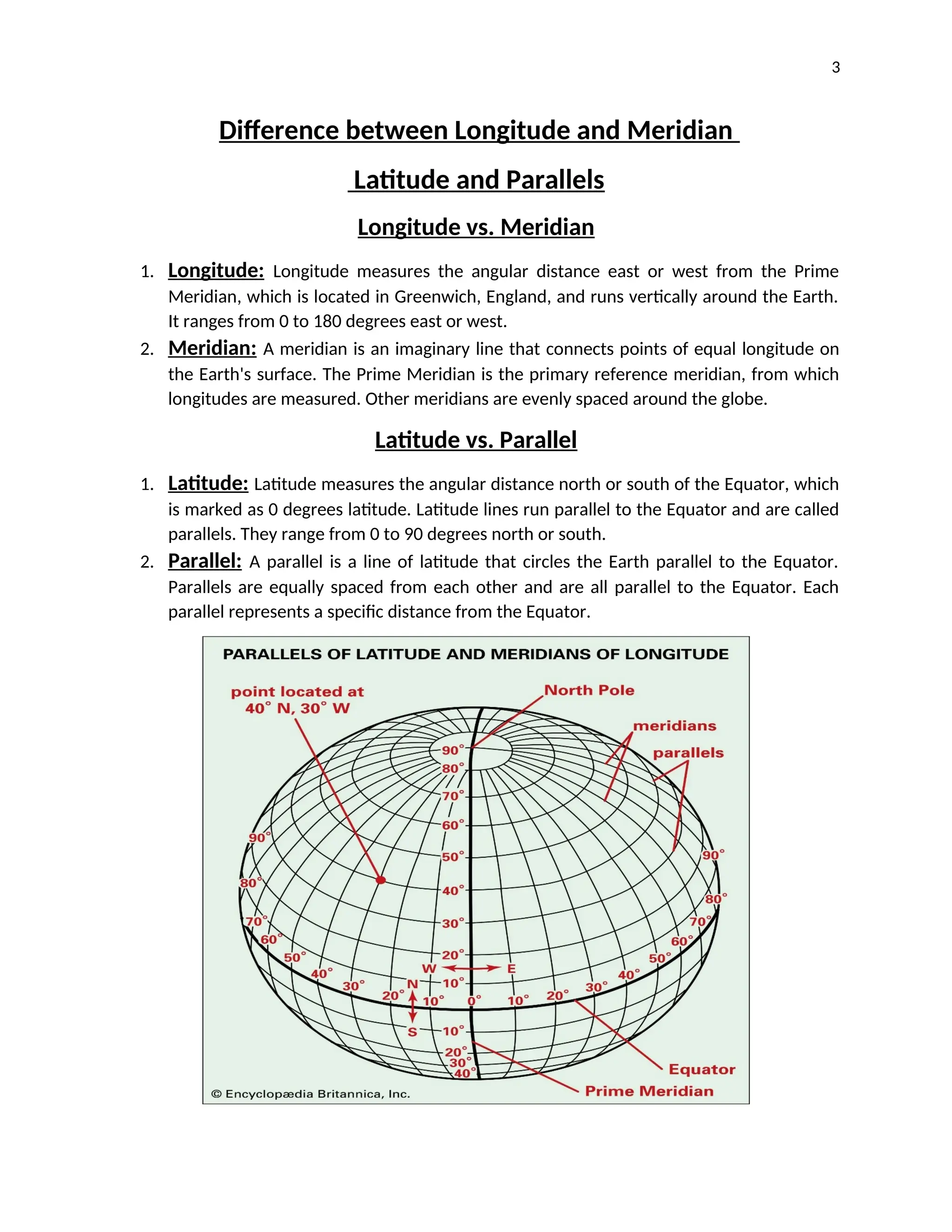
Difference between Longitudeand Meridian
Latitude and Parallels
Longitude vs. Meridian
1. Longitude: Longitude measures the angular distance east or west from the Prime
Meridian, which is located in Greenwich, England, and runs vertically around the Earth.
It ranges from 0 to 180 degrees east or west.
2. Meridian: A meridian is an imaginary line that connects points of equal longitude on
the Earth's surface. The Prime Meridian is the primary reference meridian, from which
longitudes are measured. Other meridians are evenly spaced around the globe.
Latitude vs. Parallel
1. Latitude: Latitude measures the angular distance north or south of the Equator, which
is marked as 0 degrees latitude. Latitude lines run parallel to the Equator and are called
parallels. They range from 0 to 90 degrees north or south.
2. Parallel: A parallel is a line of latitude that circles the Earth parallel to the Equator.
Parallels are equally spaced from each other and are all parallel to the Equator. Each
parallel represents a specific distance from the Equator.
4.
4
In summary, longitudeand latitude are the measurements of angular distance east-west and
north-south on the Earth's surface, respectively. Meridians and parallels are the imaginary lines
that help define these measurements. Meridians connect points of equal longitude, while
parallels are lines of latitude that run parallel to the Equator.
Prominent latitudes and longitudes
Several latitudes and longitudes hold significance due to their geographical, historical, or
navigational importance. Here are some prominent ones:
Equator (0° Latitude):
1. The Equator is the line of 0 degrees latitude, dividing the Earth into the Northern
Hemisphere and the Southern Hemisphere.
2. It is the longest line of latitude and is significant for its climatic effects and as a reference
point for navigation and geography.
Prime Meridian (0° Longitude):
1. The Prime Meridian is the line of 0 degrees longitude, passing through Greenwich,
England.
2. It serves as the reference point for measuring longitudes and is used as the basis for
determining time zones worldwide.
Tropic of Cancer (23.5° North Latitude):
1. The Tropic of Cancer is the latitude line located approximately 23.5 degrees north of the
Equator.
2. It marks the northernmost position where the sun can appear directly overhead during
the summer solstice in the Northern Hemisphere.
Tropic of Capricorn (23.5° South Latitude):
1. The Tropic of Capricorn is the latitude line located approximately 23.5 degrees south of
the Equator.
2. It marks the southernmost position where the sun can appear directly overhead during
the summer solstice in the Southern Hemisphere.
Arctic Circle (66.5° North Latitude):
1. The Arctic Circle is the latitude line located approximately 66.5 degrees north of the
Equator.
2. It marks the southernmost latitude where the sun remains above the horizon for 24
hours during the summer solstice in the Northern Hemisphere.
5.
5
Antarctic Circle (66.5°South Latitude):
1. The Antarctic Circle is the latitude line located approximately 66.5 degrees south of the
Equator.
2. It marks the northernmost latitude where the sun remains above the horizon for 24
hours during the summer solstice in the Southern Hemisphere.
These prominent latitudes and longitudes play key roles in navigation, cartography, astronomy,
and climatology, and they help define important geographic and climatic boundaries on Earth.
______________________________________________________________________________
International Date line & Time Zones
The International Date Line (IDL) and time zones are essential concepts in global timekeeping
and navigation. Here's an explanation of each:
International Date Line (IDL):
1. The International Date Line is an imaginary line that roughly follows the 180° meridian
of longitude in the Pacific Ocean.
2. It serves as the boundary between two consecutive calendar days. When you cross the
IDL from west to east (moving towards America), you subtract one day, and when you
cross from east to west (moving towards Asia), you add one day.
3. The specific path of the IDL is not straight but zigzags to accommodate political
boundaries and maintain continuity within time zones.
Time Zones:
1. Time zones are regions of the Earth that have the same standard time. They are roughly
based on lines of longitude.
2. The Earth is divided into 24 time zones, each representing 15 degrees of longitude.
These time zones are generally centered on multiples of 15 degrees away from the
Prime Meridian.
3. Most time zones are one hour apart from their neighboring zones, although some are
offset by 30 or 45 minutes for practical or political reasons.
4. Time zones are used to standardize timekeeping across the globe and ensure that clocks
in adjacent areas are relatively synchronized.
Some key points regarding time zones and the IDL:
1. Crossing the IDL can result in a change of date, but it does not always coincide with
crossing into a new time zone.
2. Countries may choose to follow different time zone boundaries or adopt Daylight Saving
Time (DST) practices, resulting in variations within regions.
6.
6
3. Some regions,such as certain islands in the Pacific Ocean, straddle the IDL, leading to
unique timekeeping practices.
4. Understanding the International Date Line and time zones is crucial for coordinating
international travel, communication, and commerce, as it helps maintain a standardized
global timekeeping system.


![Latitudes and Longitudes [Autosaved].pptx](https://cdn.slidesharecdn.com/ss_thumbnails/latitudesandlongitudesautosaved-221031193426-8f2f0591-thumbnail.jpg?width=640&height=640&fit=bounds)


