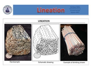
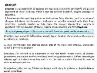
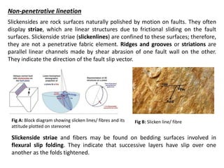
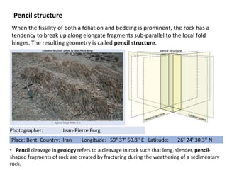
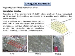
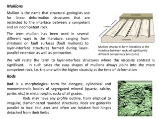
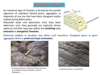
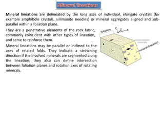
The current ppt discusses the different types of lineations formed due to deformation.
Lineations are genetically related to the foliation planes on which they occur, particularly where both are shaped by mineral orientations. Therefore, the planar and linear fabrics are both together aspects of the same three-dimensional geometry, which is related to the shape of the finite strain ellipsoid or,
more important still, to the history of incremental strains.
Komattite
Named after the Komati River in South Africa.
first described by Morris and Richard (twins) for ultramafic units in the Barberton Greenstone belt of South Africa.
Mostly of komatiite are Archean age
distributed in the Archaean shield areas.
Also a few are Proterozoic and Phanerozoic.
In all ages komatiites are highly magnesium.
Mostly a volcanic rock; occasionally intrusive.
Mafic rocks were identified as extrusive because of their volcanic textures and structures, and they seem to have been accepted as a normal component of Archean volcanic successions, Abitibi in Canada.
The ultramafic rocks were interpreted as intrusive which are founded as sills and dykes, Barberton in South Africa.
Spinifex texture-typical of Komatiites:
Structural geology is the study of the three-dimensional of the rock units with respect to their deformational histories, Structure is spatial and geometrical configuration of rock components.
Structures are classified into two types:
Primary structures.
Secondary structures
Primary structures
Structures that form during deposition or crystallization of the rock, are the result of two processes:
Settling of solid particles from fluid medium in which they have been suspended, in most of the sedimentary rocks.
Crystallization of mineral grains from a liquid in which they have been dissolved as in igneous rocks.
Boundary problems between :-
Precambrian/Cambrian
Permian/Triassic
Cretaceous/Tertiary
Neogene/Quaternary
Stratigraphic boundaries are determined by one or more of geological events such as volcanic activity, sedimentation, tectonism, paleo-environments & evolution of life.
Faunal records have played major role in determining the boundaries of the Phanerozoic units.
The other geological events are dated on the evidence of fossil records.
The name ophiolite derived from Greek root which means
Ophio : snake or serpent Litho : Stone
The green colour, structure and texture of sheared ultramafic rocks is similar to some serpents
Economically :
Massive Sulphide
It founded within pillow lava most of massive Sulphide associated in ophiolites have well developed Gossans (bright colored iron oxide, hydroxides, and sulfides) which is very rich in gold.
Chromite
Stratiform (be tabular or pencil shape) or podiform (irregular shape) within ultra-mafic rocks
These deposits are developed on serpentinite peridotite
Laterites (nickel and iron)
Asbestos
Talc
Magenesite
ophiolite sequence :
Sediments
Pillow Lavas
Dykes
Gabbros
Layered Gabbro
Layered Peridotite
Upper mantle
22 Where are the youngest rocks exposed in this area What .pdfsales80
22. Where are the youngest rocks exposed in this area? What is their age (geologic period)?
23. Where are the oldest rocks exposed in this area? What is their age (geologic period)?
24. Study the pattern made by the rock units in Michigans Lower Peninsula (between Lake
Michigan and Lake Huron). What major structural feature is shown? Provide reason(s) to support
your answer.
Hint: note the spatial outcrop pattern and the age relationship between different units (as shown by
the map legend). Remember from the lecture that domes and basins are circular features, and we
tell the two apart by the age relationship of the rock units. In a dome, the oldest rocks are in
themiddle, with younger rocks around the edges. In a basin, the youngest rocks are in the middle,
while the oldest rocks are around the edges. This is where the legend that accompanies the map
comesin. The different rock units, shown in different colors, are arranged in order in the legend
from youngest at the top to oldest at the bottom. So the legend allows you to determine the
relative agesof the rock units on the map (which are older, which are younger) and hence whether
this circular feature is a dome or a basin.
25. Note the outcrop pattern of Silurian and Devonian rocks in northwest Indiana. What major
structural feature is present in this area? How can you tell?
Hint: Notice that in this area the rock units are repeated like stripes. This indicates the presence of
a fold. You would then have to look at the relative ages of the rocks, using the legend, to tell
whether the fold is an anticline or a syncline. Synclines have the youngest rocks in the middle of
the fold; anticlines have the oldest rocks in the middle of the fold.
26. What is the oldest possible age of the folding event in NW Indiana? How can you tell?
Hint: remember the principle of original horizontality: the rock units were horizontal when they
were deposited, and only folded some time after they were deposited. Hence, the fold can be no
older than the youngest rock unit involved in the fold.
27. What is the linear feature shown on the map between Lansing and Detroit?
Hint: note that this feature is shown with a thicker line than the contacts between units shown
everywhere else on the map. If you dont know the significance of a contact drawn with a thicker
line, then you need to re-read the preceding introduction to geologic maps.
Geologic maps show the distribution of rock units at the surface as well as structural features,
such as faults and folds. A geologic map is usually printed on top of a regular topographic map
(the base map) to help you locate yourself on the map. The base map is printed with light colors,
so it doesn't interfere with seeing the geologic features on the map. The geology is represented by
colors, lines, and symbols unique to geologic maps. Each color used on a geologic map
represents a different geologic unit. A unit is a specific type of rock of a specific age range (for
example, a Perm.
Structural And Metamorphic Evolution Of The Melur Migmatites, In Melur Regio...inventionjournals
International Journal of Engineering and Science Invention (IJESI) is an international journal intended for professionals and researchers in all fields of computer science and electronics. IJESI publishes research articles and reviews within the whole field Engineering Science and Technology, new teaching methods, assessment, validation and the impact of new technologies and it will continue to provide information on the latest trends and developments in this ever-expanding subject. The publications of papers are selected through double peer reviewed to ensure originality, relevance, and readability. The articles published in our journal can be accessed online.
Geologic maps show the distribution of rock units at the sur.pdfactivefiren
Geologic maps show the distribution of rock units at the surface as well as structural features,
such as faults and folds. A geologic map is usually printed on top of a regular topographic map
(the base map) to help you locate yourself on the map. The base map is printed with light colors,
so it doesn't interfere with seeing the geologic features on the map. The geology is represented by
colors, lines, and symbols unique to geologic maps. Each color used on a geologic map
represents a different geologic unit. A unit is a specific type of rock of a specific age range (for
example, a Permian limestone, a contact late Triassic sandstone, etc). All exposures of rocks of
the same age and type are shown with the same color and are separated from other rocks by a
line representing the contact between them. The two main types of contacts shown on most
geologic maps are depositional contacts and faults. Where the original depositional contact
between geologic units is preserved, it is shown on the geologic map as a thin line. If the rocks are
in contact because of a fault, a thicker line is used to represent the fault, and the relative motion
along the fault, if known, is indicated by labeling the upthrown side and downthrown side of the
fault. For low angle (thrust) faults the teeth are on the upthrown (hanging wall) block. Each
geologic unit is assigned a set of letters to symbolize it on the map. Usually the symbol is the
combination of a capital letter followed by one or more small letters. The capital letter represents
the age (geologic period) of the unit. Examples include Q (Quaternary), K (Cretaceous), and C
(Cambrian). The small letters indicate either the name of the unit, if it has one, or the type of rock,
if the unit has no name. Many geologic units are named based on where their characteristics are
bestdisplayed, or where they were first studied. For example, Jm is the map symbol for the
Morrison formation, a stratigraphic unit of Jurassic age first studied near Morrison, Colorado but
exposed throughout Colorado, Wyoming, and Utah (the Morrison formation is the source of many
dinosaur fossils). Js would be unnamed shale (s for shale) that is Jurassic in age. Sedimentary
rocks form in broad, flat layers (beds) that may later be tilted or bent by tectonic forces. The spatial
orientation of tilted rock layers is described in terms of strike and dip. Strike is the compass
direction of a line formed by the intersection of a horizontal plane (the surface of the Earth) and an
inclined surface (the titled rock layer). Dip is the angle between a horizontal plane and the inclined
surface and is always measured perpendicular to strike. On geologic maps " T " shaped-symbols
are used show the strike and dip of each rock unit. The top of the "T" is the line of strike and the
short arm of the " T " illustrates the dip direction in degrees. The higher the number, the steeper
the bed with 90 being perpendicular to the surface (vertical). In the example h.
Indexing of toposheets, in Introduction to Million sheet, degree sheet, toposheet, and their scales.
Some practice questions based on toposheet indexing and map scale has also been given for best practice.
Gravity anomaly across reagional structuresAmit K. Mishra
Gravity Anomaly across continents and ocean, gravity anomaly across mid-oceanic ridges, gravity anomaly across orogenic belts, and gravity anomaly across subduction zones.
This report cover the field description of in and around Kutch area. the field objectives includes the brief study of tectonic evolution of Kutch rift basin by utilizing the Structural, Sedimentological and Palaeontological aspects of field.
This field provided the overall sense of structures & tectonics of Kuchchh area as well as depositional sedimentary environment. Here is the brief of the structures and fossils seen in the field:
Mechanical Structures – These structures are formed by various processes when the sediments were being deposited. They are also known as primary structures. Structures seen – Lamination, current bedding, cross bedding, graded bedding, ripple marks, sole marks, clastic intrusions.
Chemical Structures – These structures are formed by various chemical processes and are also known as secondary structures as they are formed after the deposition of the sediments.
Structures seen – concretionary structures (Iron Nodules, Shale Nodules), oolitic structures
(Dhosa Oolite), pisolitic structures.
Biological/ Organic Structures – these structures are imposed by various organisms, which include footprints of animals, self impression of plants, makings of insect tracks and trails,
fossilized wood, moulds and casts. These rocks are fossiliferrous as it contains some organic
structures and organisms in it. Structures seen: Stromatolitic Limestone, Silicified Wood, Burrows, Bioturbated Beds.
This Lecture includes the Resistivity survey, field procedure, application advantage, limitaion, Apparant resistivity, VES (Vertical Electrical Sounding), Resistivity Profiling and IP Survey in brief.
The Lectures describes the Electrical method of Geophysical Prospecting in brief. SP surveying and Occurrence of Self potential and its application is discussed in brief.
This topic includes representation of topography by various non mathematical and mathematical methods.
Pictorial method (Hachure lines, Hill shading)
Mathematical method (Spot heights,Bench marks, Trigonometrical stations, Layer tint or altitude tints, Contour lines )
Combination of different methods
This lecture includes the fold terminology and classification of folds based of different criteria.
Classification of folds based on:
Direction of closing
Attitude of axial surface
Size of interlimb angle
Profile
Ramsay Classification of folds
This notes provide the information about tectonic divisions and evolution of Himalayas. movement of Indian plate has also taken up in brief.
Tectonic Division of Himalaya
Evolution of Himalaya
Movement of Indian Plate.
Resource description_ Rasoul Sorkhabi, The himalayan Journal, 2010
Fabric of a rock is the geometric arrangement of component features in the rock, seen on a scale large enough to include many samples of each feature.
The features themselves are called fabric elements. Examples of fabric elements include mineral grains, clasts, compositional layers, fold hinges, and planes of parting.
Fabrics that form as a consequence of tectonic deformation of rock are called tectonic fabrics, and fabrics that form during the formation of the rock are called primary fabrics.
This pdf covers theory of continental drift and plate tectonics.
Continental drift
Plate Tectonics
Mantle Convection
Convection currects
Types of Mantle convection
Drivers of the plate motion.
Bibliography_ Lutgens, Tarbuk and Tasa Publisher: Prentice Hall
Operation “Blue Star” is the only event in the history of Independent India where the state went into war with its own people. Even after about 40 years it is not clear if it was culmination of states anger over people of the region, a political game of power or start of dictatorial chapter in the democratic setup.
The people of Punjab felt alienated from main stream due to denial of their just demands during a long democratic struggle since independence. As it happen all over the word, it led to militant struggle with great loss of lives of military, police and civilian personnel. Killing of Indira Gandhi and massacre of innocent Sikhs in Delhi and other India cities was also associated with this movement.
We all have good and bad thoughts from time to time and situation to situation. We are bombarded daily with spiraling thoughts(both negative and positive) creating all-consuming feel , making us difficult to manage with associated suffering. Good thoughts are like our Mob Signal (Positive thought) amidst noise(negative thought) in the atmosphere. Negative thoughts like noise outweigh positive thoughts. These thoughts often create unwanted confusion, trouble, stress and frustration in our mind as well as chaos in our physical world. Negative thoughts are also known as “distorted thinking”.
Synthetic Fiber Construction in lab .pptxPavel ( NSTU)
Synthetic fiber production is a fascinating and complex field that blends chemistry, engineering, and environmental science. By understanding these aspects, students can gain a comprehensive view of synthetic fiber production, its impact on society and the environment, and the potential for future innovations. Synthetic fibers play a crucial role in modern society, impacting various aspects of daily life, industry, and the environment. ynthetic fibers are integral to modern life, offering a range of benefits from cost-effectiveness and versatility to innovative applications and performance characteristics. While they pose environmental challenges, ongoing research and development aim to create more sustainable and eco-friendly alternatives. Understanding the importance of synthetic fibers helps in appreciating their role in the economy, industry, and daily life, while also emphasizing the need for sustainable practices and innovation.
Read| The latest issue of The Challenger is here! We are thrilled to announce that our school paper has qualified for the NATIONAL SCHOOLS PRESS CONFERENCE (NSPC) 2024. Thank you for your unwavering support and trust. Dive into the stories that made us stand out!
Palestine last event orientationfvgnh .pptxRaedMohamed3
An EFL lesson about the current events in Palestine. It is intended to be for intermediate students who wish to increase their listening skills through a short lesson in power point.
How to Create Map Views in the Odoo 17 ERPCeline George
The map views are useful for providing a geographical representation of data. They allow users to visualize and analyze the data in a more intuitive manner.
How to Split Bills in the Odoo 17 POS ModuleCeline George
Bills have a main role in point of sale procedure. It will help to track sales, handling payments and giving receipts to customers. Bill splitting also has an important role in POS. For example, If some friends come together for dinner and if they want to divide the bill then it is possible by POS bill splitting. This slide will show how to split bills in odoo 17 POS.
2. Lineation is a general term to describe any repeated, commonly penetrative and parallel
alignment of linear elements within a rock (to envision lineation, imagine packages of
spaghetti).
Lineation
A lineation may be a primary igneous or sedimentary fabric element, such as an array of
elongate K-feldspar porphyroblasts, inclusions or pebbles oriented with their long
dimensions mutually parallel, or flute casts. The primary alignment of markers is
correlated with the direction of flow of magma or paleocurrent and form flow lines.
Structural geology is particularly concerned with lineations produced by deformation.
Lineations due to ductile deformation actually lay on foliation planes and are therefore as
penetrative as foliations.
A single deformation may produce several sets of lineations with different orientations
within a given foliation plane.
Lineations are referred to as L-elements of the rock fabric. Where L-lines of different
generations are present in the same fabric, they are given numerical suffixes according to
relative age: L0 is the primary line and L1, L2 , Ln are secondary lineations in order of
determined superposition.
Lineated rocks that are not foliated are known, particularly in gneisses, as L-tectonites (or
pencil tectonites).
3. Description
The attitude of a linear structure is described by its trend, which is the compass direction of
the lineation projected on a horizontal plane, and its plunge. The plunge is the angle made
by the linear structure with the horizontal, in the vertical plane parallel to its trend. The
rake (or pitch) is the angle between a line lying in a plane with the horizontal strike of the
same plane. Therefore it is an angle not measured in a vertical or horizontal plane but in
the plane that contains the linear structure. This angle is often used to measure slickenside
striations on a fault plane.
Orientation
4. Non-penetrative lineation
Slickensides are rock surfaces naturally polished by motion on faults. They often
display striae, which are linear structures due to frictional sliding on the fault
surfaces. Slickenside striae (slickenlines) are confined to these surfaces; therefore,
they are not a penetrative fabric element. Ridges and grooves or striations are
parallel linear channels made by shear abrasion of one fault wall on the other.
They indicate the direction of the fault slip vector.
Slickenside striae and fibers may be found on bedding surfaces involved in
flexural slip folding. They indicate that successive layers have slip over one
another as the folds tightened.
Fig A: Block diagram showing slicken lines/ fibres and its
attitude plotted on stereonet
Fig B: Slicken line/ fibre
5. Intersection lineations
Since any two planar surfaces intersect in a line, most rocks that are folded with
concomitant development of an axial plane foliation display the intersection
lineation between bedding and the axial plane foliation.
The trace of bedding on an
intersecting foliation plane commonly
appears as colour stripes generally
parallel to local fold axes (hence it is
sometimes called striping lineation to
avoid using a genetic term)
Two non-parallel foliations can also produce an
intersection lineation; for example, the
intersection of a crenulation cleavage and the
earlier foliation.
Note : The linear trace of any plane on a random joint surface has no significance
in structural analysis; a lineation must be measured on and only on the foliation
plane of the same deformation episode. Intersection lineation, however, may
also be measured on the bedding plane.
6. When the fissility of both a foliation and bedding is prominent, the rock has a
tendency to break up along elongate fragments sub-parallel to the local fold
hinges. The resulting geometry is called pencil structure.
Pencil structure
Place: Bent Country: Iran Longitude: 59° 37' 50.8'' E Latitude: 26° 24' 30.3'' N
Photographer: Jean-Pierre Burg
• Pencil cleavage in geology refers to a cleavage in rock such that long, slender, pencil-
shaped fragments of rock are created by fracturing during the weathering of a sedimentary
rock.
7. Axes of folds as lineations
Hinges of cylindrical folds are linear structures.
Crenulation lineation
Rocks that are finely laminated and affected by intense small-scale folding (crenulation)
exhibit a strongly developed linear structure due to the abundant parallel fold hinges that
permeate the rock.
Slaty or schistose rocks frequently exhibit two or
more sets of such crenulations and crenelation
cleavages, and individual foliation surfaces may then
contain two intersecting sets of crenulation
lineations forming a small-scale interference pattern.
Photo 2Photo 1 Photo 3
8. Mullions
Mullion is the name that structural geologists use
for linear deformation structures that are
restricted to the interface between a competent
and an incompetent rock.
The term mullion has been used in several
different ways in the literature, ranging from
striations on fault surfaces (fault mullions) to
layer-interface structures formed during layer-
parallel extension as well as contraction.
Mullion structures form lineations at the
interface between rocks of significantly
different competence (viscosity)
We will relate the term to layer-interface structures where the viscosity contrast is
significant. In such cases the cusp shapes of mullions always point into the more
competent rock, i.e. the one with the higher viscosity at the time of deformation
Rods
Rod is a morphological term for elongate, cylindrical and
monomineralic bodies of segregated mineral (quartz, calcite,
pyrite, etc.) in metamorphic rocks of all grades.
Rods may have any profile outline, from elliptical to
irregular, dismembered rounded structures. Rods are generally
parallel to local fold axes and often are isolated fold hinges
detached from their limbs
9. An important type of lineation is formed by the parallel
alignment of individual detrital grains, aggregates or
fragments of any size that have been elongated and/or
rotated during deformation.
Ellipsoidal ooids and spherulites must have been
deformed, since they generally are originally almost
spherical and their long axes define the stretching (also
extension or elongation) lineation.
Deformed pebbles or boulders also define such lineations. Elongated grains or grain
aggregates define a preferred shape orientation.
Stretching lineation on mylonitic foliation planes of
an amphibolite. West of Antalaha, northern
Madagascar.
Stretching lineation in amphibolite
10. Mineral lineations are delineated by the long axes of individual, elongate crystals (for
example amphibole crystals, sillimanite needles) or mineral aggregates aligned and sub-
parallel within a foliation plane.
They are a penetrative elements of the rock fabric,
commonly coincident with other types of lineation,
and serve to reinforce them.
Mineral lineations may be parallel or inclined to the
axes of related folds. They indicate a stretching
direction if the involved minerals are segmented along
the lineation; they also can define intersection
between foliation planes and rotation axes of rotating
minerals.
11. 1. Cloos E. - 1946. Lineation: A critical review and annoted bibliography. Geological
Society of America Memoir 18, 1-122.
2. Fossen, H. (2016). Structural geology. Cambridge University Press.
3. Ghosh, S. K. (2013). Structural geology: Fundamentals and modern developments.
Elsevier.
4. Park, R. G. (2013). Foundation of structural geology. Routledge.
5. Passchier C.W. & Trouw R.A.J. - 1996. Microtectonics. Springer-Verlag, Berlin, 289 p.
6. Sanderson D.J. - 1974. Patterns of boudinage and apparent stretching lineation
developped in folded rocks. Journal of Geology 82 (5), 651-661.
7. Schwerdtner W.M. - 1973. Schistosity and penetrative mineral lineation as indicators of
paleostrain directions. Canadian Journal of Earth Sciences 10 (8), 1233-1243
Editor's Notes
Intersection lineations and pencil structures are often utilised to determine the orientation of the foldaxes where they are not exposed.
The lineation is developed perpendicular to original maximum stress direction σ1 and parallel to σ3 (minimum stress direction).
Metamorphic minerals often grow with a preferred crystallographic and dimensional orientation, i.e.with their long axes in parallel alignment.
"Pressure shadow" or ''pressure fringe'' structures generally comprise spindle-shaped aggregates ofnew grains formed on opposed sides of a host porphyroblast or competent, clastic objects. The newgrains crystallize when material dissolved by pressure solution is re-precipitated, occasionally asfibres, in the regions sheltered from strain on either side of the rigid grains. The fibres form tailsfilling openings in the extending direction between grain and matrix, during deformation. The centralgrain and the tails produce an elongate structure generally contained in the foliation; this structure and the fibre crystals thus define a lineation. Circular fringes with radial fibres on the foliationhowever characterize pure shear without stretching direction (pan-cake finite strain ellipsoid). In asimilar way, the oriented growth of mineral fibres in tensions gashes and veins indicates the localextension direction and may record incremental strain directions.