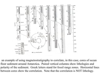
Introduction to stratigraphy
Establishing relationships between
rocks
Formation - a mappable group of rocks with
characteristics that enable you distinguish it
from units above and below
• Formations can be subdivided into
“Members”
• Formations can be grouped into “Groups”
Ex: Trenton Group
Glens Falls Formation
Larabee Member
A cross section of the rocks that comprise part of the
Grand Canyon
If the Tapeats Ss represents a shoreline sand, then you can see that as sea level
changed and the beach moved, the Tapeats is a different age at different locations in
Arizona. Rock formations do not represent time.
How do we “correlate” rocks?
correlation = establishing equivalency
• Physical Stratigraphy:
1. Lithostratigraphy = establishing similarity of
rock type = the same environment and resulting
rock. NOT a matter of establishing age or age
equivalency
2. Magnetostratigraphy = using similar magnetic
polarity to establish age equivalency (because the
same rocks that record a strong magnetism are
those that can be dated by radiometric decay)
3. Sequence Stratigraphy = sea level curves
Biostratigraphy = using fossils to establish age equivalency
1. zones or biozones - the time interval between
the first and last appearance of a fossil or fossils
2. position within evolutionary lineages - for
traits that change gradually over time you can tell
the age of the fossil-bearing rock layer
3. Index fossil - a fossil that existed for a short period
of time in earth history; its presence indicates an
interval of time
Chronostratigraphy = establishing isochrons, or “time
lines.”This is usually accomplished through the use of
marker beds that represent a “geologic instant” in time,
like a volcanic ash layer.
Lithostratigraphic
correlation
practice
The unconformity surface can be considered an isochron (an
horizon of equal time)
Magnetostratigraphy is based on
the idea of correlating rocks
based on the sequence of polarity
reversals they record. Shown here
is the polarity reversal record of
the past 69 Ma. Each period of
normal and reversed polarity is
termed a “chron.” These chrons
were determined by sampling long
continuous records of sediment
that are well dated by fossils.
the ages of the various polarity
reversals are then known.
The very best use of magnetostrat-
igraphy is that it enables you to
correlate from marine to non-
marine environments, something no
other correlation technique permits.
an example of using magnetostratigraphy to correlate, in this case, cores of ocean
floor sediment around Antarctica. Paired vertical columns show lithologies and
polarity of the sediment. Greek letters stand for fossil range zones. Horizontal lines
between cores show the correlation. Note that the correlation is NOT lithology.
An example of how range zones are used to establish the age of
rock layers. Here are the distributions of fossil graptolites in
Silurian rocks. You can see that there is a horizon where the fauna
changes its composition (arrows pointing downward are graptolite
species that existed up until this time; arrows pointing upward are
graptolite species that exist from that time onward) This is the zone
boundary. Some species exist for long time periods. The two
graptolite species for which the zones are named are shown.
Techniques of biostratigraphy:
Range zones. In ‘A” the range
is the interval of time when the
species existed. In “B” the
range = the interval of time
when two species overlapped.
In “C” range = the interval of
time when one species existed
but the other did not.
Stratigraphy i

Stratigraphy i

  • 1.
    Introduction to stratigraphy Establishingrelationships between rocks
  • 2.
    Formation - amappable group of rocks with characteristics that enable you distinguish it from units above and below • Formations can be subdivided into “Members” • Formations can be grouped into “Groups” Ex: Trenton Group Glens Falls Formation Larabee Member
  • 3.
    A cross sectionof the rocks that comprise part of the Grand Canyon If the Tapeats Ss represents a shoreline sand, then you can see that as sea level changed and the beach moved, the Tapeats is a different age at different locations in Arizona. Rock formations do not represent time.
  • 4.
    How do we“correlate” rocks? correlation = establishing equivalency • Physical Stratigraphy: 1. Lithostratigraphy = establishing similarity of rock type = the same environment and resulting rock. NOT a matter of establishing age or age equivalency 2. Magnetostratigraphy = using similar magnetic polarity to establish age equivalency (because the same rocks that record a strong magnetism are those that can be dated by radiometric decay) 3. Sequence Stratigraphy = sea level curves
  • 5.
    Biostratigraphy = usingfossils to establish age equivalency 1. zones or biozones - the time interval between the first and last appearance of a fossil or fossils 2. position within evolutionary lineages - for traits that change gradually over time you can tell the age of the fossil-bearing rock layer 3. Index fossil - a fossil that existed for a short period of time in earth history; its presence indicates an interval of time Chronostratigraphy = establishing isochrons, or “time lines.”This is usually accomplished through the use of marker beds that represent a “geologic instant” in time, like a volcanic ash layer.
  • 6.
  • 9.
    The unconformity surfacecan be considered an isochron (an horizon of equal time)
  • 11.
    Magnetostratigraphy is basedon the idea of correlating rocks based on the sequence of polarity reversals they record. Shown here is the polarity reversal record of the past 69 Ma. Each period of normal and reversed polarity is termed a “chron.” These chrons were determined by sampling long continuous records of sediment that are well dated by fossils. the ages of the various polarity reversals are then known. The very best use of magnetostrat- igraphy is that it enables you to correlate from marine to non- marine environments, something no other correlation technique permits.
  • 12.
    an example ofusing magnetostratigraphy to correlate, in this case, cores of ocean floor sediment around Antarctica. Paired vertical columns show lithologies and polarity of the sediment. Greek letters stand for fossil range zones. Horizontal lines between cores show the correlation. Note that the correlation is NOT lithology.
  • 13.
    An example ofhow range zones are used to establish the age of rock layers. Here are the distributions of fossil graptolites in Silurian rocks. You can see that there is a horizon where the fauna changes its composition (arrows pointing downward are graptolite species that existed up until this time; arrows pointing upward are graptolite species that exist from that time onward) This is the zone boundary. Some species exist for long time periods. The two graptolite species for which the zones are named are shown.
  • 14.
    Techniques of biostratigraphy: Rangezones. In ‘A” the range is the interval of time when the species existed. In “B” the range = the interval of time when two species overlapped. In “C” range = the interval of time when one species existed but the other did not.