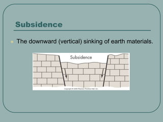
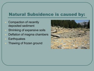
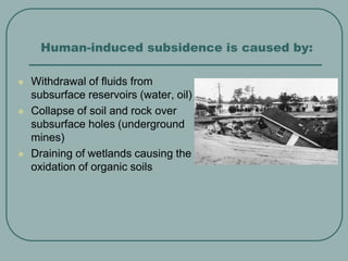
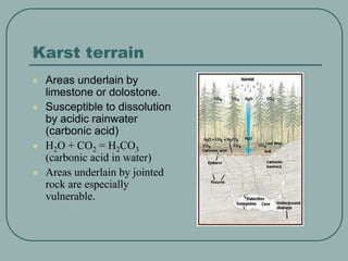
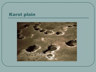
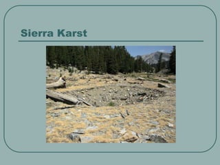
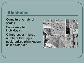
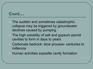
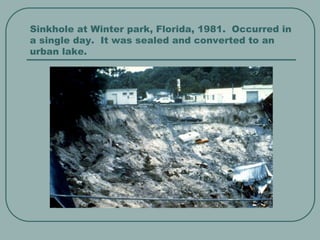
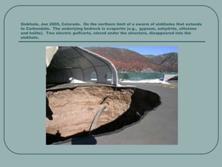
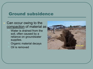
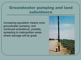
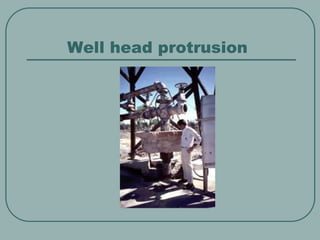
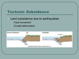
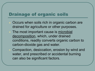
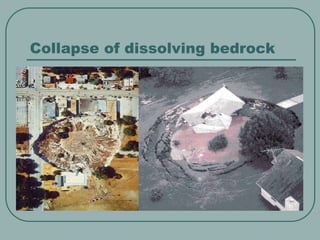
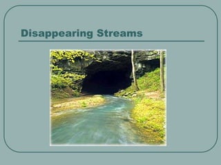
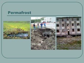
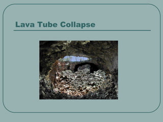
This document summarizes different types of land subsidence. It discusses natural subsidence caused by compaction of sediments, shrinking of soils, volcanic processes, earthquakes, and thawing of frozen ground. It also describes human-induced subsidence from fluid withdrawal, mine collapses, and draining of wetlands. Specific types covered include subsidence in karst terrain due to dissolution in limestone areas, sinkhole formation which can be catastrophic or slow, and subsidence caused by groundwater pumping, drainage of organic soils, and tectonic processes like earthquakes. Potential hazards from subsidence are contaminated water supplies and loss of infrastructure, but it can also create new lakes.
Land subsidence: what is it and why do we care?EMA-tucson
Arizona land subsidence occurrence, causes, and impacts, with maps and photos. Land subsidence is common in areas of groundwater overdraft. This presentation was made by Leslie Katz, principal hydrogeologist with M&A, at luncheon of the Arizona Women’s Envirolink (AWE) group.
Groundwater models are simplified representation of large and real hydrogeologic systems like river basins or watersheds. GWM is attempted to analyse the mechanisms which control the occurrence and movement of groundwater and to evaluate the policies, actions and designs which may affect the systems. These models are less complex prototypes of complex hydrogeologic systems developed using spatially varying aquifer parameters, hydrologic properties, geologic boundary conditions and positions of withdrawal wells or recharging structures. These are designed to compute how pumping or recharge might affect the local or regional groundwater levels.
It includes the definition, properties, classification of groundwater with appropriate examples and figures in details. It also deals about the formation of groundwater. The properties of aquifers (all of 7) are described here in details with figures and mathematical terms.
It is refers to the downward sliding of huge quantities of land mass
Downward movement of slope forming material composed of rocks and soil or combination of all these material along surfaces of separation by FALLING, SLIDING AND FLOWING either sudden or slow from one place to another place.
Definition, classification & types of landslideTarikIslam9
General Information about Bangladesh
Bangladesh is consisted of a total land area of 147570 km² with hilly areas of 17,342 km² (8.5% of total area of Bangladesh).
Chattagram Hill tracts is the wide ranging hilly area in the southeastern part of the country. Rangamati, Bandarban and Khagrachari are three unique geographical and cultural landscape administrative districts in this region.
Landslides are a common hazard in the Chittagong Hill Districts (CHD) of Bangladesh. The communities that live on dangerous hill slopes in CHD repeatedly experience landslide hazards during the monsoon season, with casualties, economic losses and property damage.
This lecture includes the fold terminology and classification of folds based of different criteria.
Classification of folds based on:
Direction of closing
Attitude of axial surface
Size of interlimb angle
Profile
Ramsay Classification of folds
Hello! I've created this PowerPoint presentation as a requisite in Disaster Readiness and Risk Reduction subject during SY 2019–2020.
Other Geological Hazards
- Bolide Impact
- Ground Subsidence
- Coastal Erosion
Should you need a .pptx file, kindly email me at rd.chrxlr@gmail.com.
soil erosion is the one of the severe problem now a days. we should know about types of soil erosion , its effect on environment and how it to be prevented by various method..in these slides gives brief idea about types and erosion of soil erosion.
How to Create Map Views in the Odoo 17 ERPCeline George
The map views are useful for providing a geographical representation of data. They allow users to visualize and analyze the data in a more intuitive manner.
Read| The latest issue of The Challenger is here! We are thrilled to announce that our school paper has qualified for the NATIONAL SCHOOLS PRESS CONFERENCE (NSPC) 2024. Thank you for your unwavering support and trust. Dive into the stories that made us stand out!
Palestine last event orientationfvgnh .pptxRaedMohamed3
An EFL lesson about the current events in Palestine. It is intended to be for intermediate students who wish to increase their listening skills through a short lesson in power point.
Model Attribute Check Company Auto PropertyCeline George
In Odoo, the multi-company feature allows you to manage multiple companies within a single Odoo database instance. Each company can have its own configurations while still sharing common resources such as products, customers, and suppliers.
How to Split Bills in the Odoo 17 POS ModuleCeline George
Bills have a main role in point of sale procedure. It will help to track sales, handling payments and giving receipts to customers. Bill splitting also has an important role in POS. For example, If some friends come together for dinner and if they want to divide the bill then it is possible by POS bill splitting. This slide will show how to split bills in odoo 17 POS.
Ethnobotany and Ethnopharmacology:
Ethnobotany in herbal drug evaluation,
Impact of Ethnobotany in traditional medicine,
New development in herbals,
Bio-prospecting tools for drug discovery,
Role of Ethnopharmacology in drug evaluation,
Reverse Pharmacology.
Operation “Blue Star” is the only event in the history of Independent India where the state went into war with its own people. Even after about 40 years it is not clear if it was culmination of states anger over people of the region, a political game of power or start of dictatorial chapter in the democratic setup.
The people of Punjab felt alienated from main stream due to denial of their just demands during a long democratic struggle since independence. As it happen all over the word, it led to militant struggle with great loss of lives of military, police and civilian personnel. Killing of Indira Gandhi and massacre of innocent Sikhs in Delhi and other India cities was also associated with this movement.
The French Revolution, which began in 1789, was a period of radical social and political upheaval in France. It marked the decline of absolute monarchies, the rise of secular and democratic republics, and the eventual rise of Napoleon Bonaparte. This revolutionary period is crucial in understanding the transition from feudalism to modernity in Europe.
For more information, visit-www.vavaclasses.com
3. Natural Subsidence is caused by:
Compaction of recently
deposited sediment
Shrinking of expansive soils
Deflation of magma chambers
Earthquakes
Thawing of frozen ground
4. Human-induced subsidence is caused by:
Withdrawal of fluids from
subsurface reservoirs (water, oil)
Collapse of soil and rock over
subsurface holes (underground
mines)
Draining of wetlands causing the
oxidation of organic soils
5. Karst terrain
Areas underlain by
limestone or dolostone.
Susceptible to dissolution
by acidic rainwater
(carbonic acid)
H2O + CO2 = H2CO3
(carbonic acid in water)
Areas underlain by jointed
rock are especially
vulnerable.
8. Sinkholes
Come in a variety of
scales.
Some may be
individuals.
Others occur in large
numbers forming a
pockmarked plain known
as a karst plain.
9. Cont…
The sudden and sometimes catastrophic
collapse may be triggered by groundwater
declines caused by pumping
The high solubility of salt and gypsum permit
cavities to form in days to years
Carbonate bedrock: slow process- centuries to
millennia
Human activities expedite cavity formation
10. Sinkhole at Winter park, Florida, 1981. Occurred in
a single day. It was sealed and converted to an
urban lake.
11. Sinkhole, Jan 2005, Colorado. On the northern limit of a swarm of sinkholes that extends
to Carbondale. The underlying bedrock is evaporite (e.g., gypsum, anhydrite, siltstone
and halite). Two electric golfcarts, stored under the structure, disappeared into the
sinkhole.
12. Slow Subsidence
Less obvious than catastrophic sinkhole formation
Develops gradually and is typically widespread
Mapping is critical: InSAR (inteferometric synthetic
aperture radar) uses repeat-pass radar images
from Earth-orbiting satellites to measure
subsidence at sub-centimeter resolution
13. Ground subsidence
Can occur owing to the
compaction of material as
• Water is drained from the
soil, often caused by a
reliance on groundwater
supplies.
• Organic material decays
• Oil is removed
14. Groundwater pumping and land
subsidence
Increasing population means more
groundwater pumping, and
continued subsidence, possibly
spreading to metropolitan areas
where damage will be great.
18. Drainage of organic soils
Occurs when soils rich in organic carbon are
drained for agriculture or other purposes.
The most important cause is microbial
decomposition, which, under drained
conditions, readily converts organic carbon to
carbon-dioxide gas and water.
Compaction, desiccation, erosion by wind and
water, and prescribed or accidental burning
can also be significant factors.
19. Hazards?
Easily polluted water supplies
• Rapid water flow and little filtration. Point source
pollution drains rapidly to drinking water source.
• Three municipal sewage lagoons have collapsed in
southeastern Minnesota, sending millions of gallons of
sewage to the aquifer!
• And what about…manure storage areas; feedlot
runoff…
Loss of buildings and infrastructure
24. Benefits
Karst provides unique and seldomly
explored frontier
Caves contain many rare endemic
species
• Troglobites
New sinkholes create new lakes