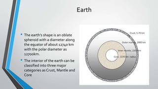
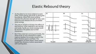
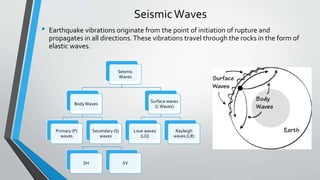
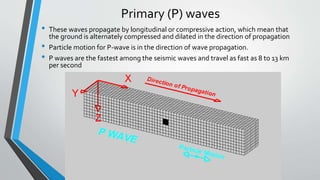
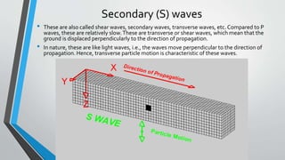
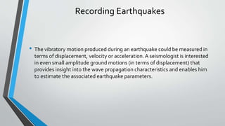
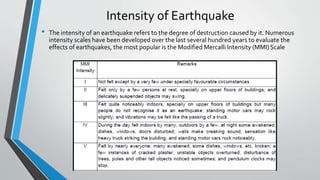
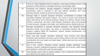
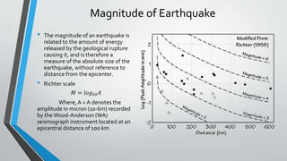
The document provides an overview of earthquakes and seismology. It discusses key topics such as:
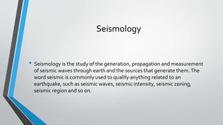
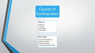
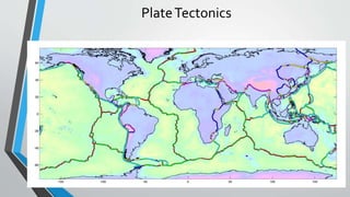
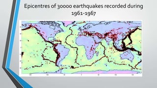
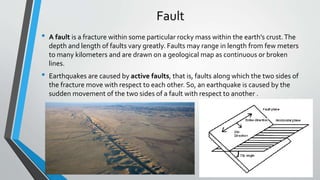
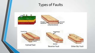
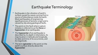
- Seismology is the study of earthquakes and seismic waves. Earthquakes are caused by the sudden movement of tectonic plates.
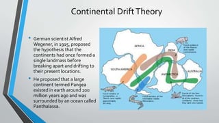
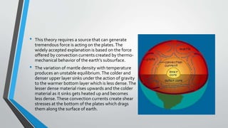
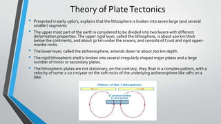
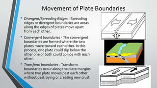
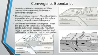
- The movement of tectonic plates is driven by convection currents in the earth's mantle. As plates move against each other, strain builds up at plate boundaries and is released through earthquakes.
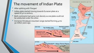
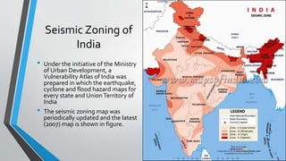
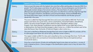
- India experiences earthquakes due to its location in a seismically active zone where the Indian plate is moving northward into the Eurasian plate. The country is divided into several seismic zones based on expected earthquake intensities.
This presentation gives detailed information about earthquake , its types , waves , faults , especially in asian countries .A detailed case study of earthquake In NEPAL in 2015 is also covered in this with pictures . Also how it is measured and its warning system , vulnerability, deployment and future aspects has been covered .
HOPE YOU LIKE IT AND GET FULL INFORMATION!!!!!
this paper tells about reasons for earthquakes, how the earthquakes happen,earthquake effects on buildings,how the buildings are respond to the earthquakes and design methods to be fallowed while designing a structure to resist earthquakes
WHAT IS AN EARTHQUAKE?
Where Do Earthquakes Happen?
Why Do Earthquakes Happen?
How Are Earthquakes Studied?
How To Locate The Earthquake's Epicenter?
SCALES FOR EARTHQUAKE MEASUREMENT
What Are Earthquake Hazards?
WHAT IS AN EARTHQUAKE?
Where Do Earthquakes Happen?
Why Do Earthquakes Happen?
How Are Earthquakes Studied?
How To Locate The Earthquake's Epicenter?
SCALES FOR EARTHQUAKE MEASUREMENT
What Are Earthquake Hazards?
Earthquakes are the shaking, rolling or sudden shock of the earth’s surface. They are the Earth's natural means of releasing stress. Earthquakes can be felt over large areas.
Earthquakes cannot be predicted, although scientists are working on it.
Courier management system project report.pdfKamal Acharya
It is now-a-days very important for the people to send or receive articles like imported furniture, electronic items, gifts, business goods and the like. People depend vastly on different transport systems which mostly use the manual way of receiving and delivering the articles. There is no way to track the articles till they are received and there is no way to let the customer know what happened in transit, once he booked some articles. In such a situation, we need a system which completely computerizes the cargo activities including time to time tracking of the articles sent. This need is fulfilled by Courier Management System software which is online software for the cargo management people that enables them to receive the goods from a source and send them to a required destination and track their status from time to time.
Quality defects in TMT Bars, Possible causes and Potential Solutions.PrashantGoswami42
Maintaining high-quality standards in the production of TMT bars is crucial for ensuring structural integrity in construction. Addressing common defects through careful monitoring, standardized processes, and advanced technology can significantly improve the quality of TMT bars. Continuous training and adherence to quality control measures will also play a pivotal role in minimizing these defects.
About
Indigenized remote control interface card suitable for MAFI system CCR equipment. Compatible for IDM8000 CCR. Backplane mounted serial and TCP/Ethernet communication module for CCR remote access. IDM 8000 CCR remote control on serial and TCP protocol.
• Remote control: Parallel or serial interface.
• Compatible with MAFI CCR system.
• Compatible with IDM8000 CCR.
• Compatible with Backplane mount serial communication.
• Compatible with commercial and Defence aviation CCR system.
• Remote control system for accessing CCR and allied system over serial or TCP.
• Indigenized local Support/presence in India.
• Easy in configuration using DIP switches.
Technical Specifications
Indigenized remote control interface card suitable for MAFI system CCR equipment. Compatible for IDM8000 CCR. Backplane mounted serial and TCP/Ethernet communication module for CCR remote access. IDM 8000 CCR remote control on serial and TCP protocol.
Key Features
Indigenized remote control interface card suitable for MAFI system CCR equipment. Compatible for IDM8000 CCR. Backplane mounted serial and TCP/Ethernet communication module for CCR remote access. IDM 8000 CCR remote control on serial and TCP protocol.
• Remote control: Parallel or serial interface
• Compatible with MAFI CCR system
• Copatiable with IDM8000 CCR
• Compatible with Backplane mount serial communication.
• Compatible with commercial and Defence aviation CCR system.
• Remote control system for accessing CCR and allied system over serial or TCP.
• Indigenized local Support/presence in India.
Application
• Remote control: Parallel or serial interface.
• Compatible with MAFI CCR system.
• Compatible with IDM8000 CCR.
• Compatible with Backplane mount serial communication.
• Compatible with commercial and Defence aviation CCR system.
• Remote control system for accessing CCR and allied system over serial or TCP.
• Indigenized local Support/presence in India.
• Easy in configuration using DIP switches.
Sachpazis:Terzaghi Bearing Capacity Estimation in simple terms with Calculati...Dr.Costas Sachpazis
Terzaghi's soil bearing capacity theory, developed by Karl Terzaghi, is a fundamental principle in geotechnical engineering used to determine the bearing capacity of shallow foundations. This theory provides a method to calculate the ultimate bearing capacity of soil, which is the maximum load per unit area that the soil can support without undergoing shear failure. The Calculation HTML Code included.
Cosmetic shop management system project report.pdfKamal Acharya
Buying new cosmetic products is difficult. It can even be scary for those who have sensitive skin and are prone to skin trouble. The information needed to alleviate this problem is on the back of each product, but it's thought to interpret those ingredient lists unless you have a background in chemistry.
Instead of buying and hoping for the best, we can use data science to help us predict which products may be good fits for us. It includes various function programs to do the above mentioned tasks.
Data file handling has been effectively used in the program.
The automated cosmetic shop management system should deal with the automation of general workflow and administration process of the shop. The main processes of the system focus on customer's request where the system is able to search the most appropriate products and deliver it to the customers. It should help the employees to quickly identify the list of cosmetic product that have reached the minimum quantity and also keep a track of expired date for each cosmetic product. It should help the employees to find the rack number in which the product is placed.It is also Faster and more efficient way.
Industrial Training at Shahjalal Fertilizer Company Limited (SFCL)MdTanvirMahtab2
This presentation is about the working procedure of Shahjalal Fertilizer Company Limited (SFCL). A Govt. owned Company of Bangladesh Chemical Industries Corporation under Ministry of Industries.
Saudi Arabia stands as a titan in the global energy landscape, renowned for its abundant oil and gas resources. It's the largest exporter of petroleum and holds some of the world's most significant reserves. Let's delve into the top 10 oil and gas projects shaping Saudi Arabia's energy future in 2024.
Immunizing Image Classifiers Against Localized Adversary Attacksgerogepatton
This paper addresses the vulnerability of deep learning models, particularly convolutional neural networks
(CNN)s, to adversarial attacks and presents a proactive training technique designed to counter them. We
introduce a novel volumization algorithm, which transforms 2D images into 3D volumetric representations.
When combined with 3D convolution and deep curriculum learning optimization (CLO), itsignificantly improves
the immunity of models against localized universal attacks by up to 40%. We evaluate our proposed approach
using contemporary CNN architectures and the modified Canadian Institute for Advanced Research (CIFAR-10
and CIFAR-100) and ImageNet Large Scale Visual Recognition Challenge (ILSVRC12) datasets, showcasing
accuracy improvements over previous techniques. The results indicate that the combination of the volumetric
input and curriculum learning holds significant promise for mitigating adversarial attacks without necessitating
adversary training.
Student information management system project report ii.pdfKamal Acharya
Our project explains about the student management. This project mainly explains the various actions related to student details. This project shows some ease in adding, editing and deleting the student details. It also provides a less time consuming process for viewing, adding, editing and deleting the marks of the students.
Explore the innovative world of trenchless pipe repair with our comprehensive guide, "The Benefits and Techniques of Trenchless Pipe Repair." This document delves into the modern methods of repairing underground pipes without the need for extensive excavation, highlighting the numerous advantages and the latest techniques used in the industry.
Learn about the cost savings, reduced environmental impact, and minimal disruption associated with trenchless technology. Discover detailed explanations of popular techniques such as pipe bursting, cured-in-place pipe (CIPP) lining, and directional drilling. Understand how these methods can be applied to various types of infrastructure, from residential plumbing to large-scale municipal systems.
Ideal for homeowners, contractors, engineers, and anyone interested in modern plumbing solutions, this guide provides valuable insights into why trenchless pipe repair is becoming the preferred choice for pipe rehabilitation. Stay informed about the latest advancements and best practices in the field.
Event Management System Vb Net Project Report.pdfKamal Acharya
In present era, the scopes of information technology growing with a very fast .We do not see any are untouched from this industry. The scope of information technology has become wider includes: Business and industry. Household Business, Communication, Education, Entertainment, Science, Medicine, Engineering, Distance Learning, Weather Forecasting. Carrier Searching and so on.
My project named “Event Management System” is software that store and maintained all events coordinated in college. It also helpful to print related reports. My project will help to record the events coordinated by faculties with their Name, Event subject, date & details in an efficient & effective ways.
In my system we have to make a system by which a user can record all events coordinated by a particular faculty. In our proposed system some more featured are added which differs it from the existing system such as security.
2. Seismology
• Seismology is the study of the generation, propagation and measurement
of seismic waves through earth and the sources that generate them.The
word seismic is commonly used to qualify anything related to an
earthquake, such as seismic waves, seismic intensity, seismic zoning,
seismic region and so on.
4. Earth
• The earth’s shape is an oblate
spheroid with a diameter along
the equator of about 12740 km
with the polar diameter as
12700km.
• The interior of the earth can be
classified into three major
categories as Crust, Mantle and
Core
5. Continental DriftTheory
• German scientist Alfred
Wegener, in 1915, proposed
the hypothesis that the
continents had once formed a
single landmass before
breaking apart and drifting to
their present locations.
• He proposed that a large
continent termed Pangea
existed in earth around 200
million years ago and was
surrounded by an ocean called
Panthalassa.
6. • This theory requires a source that can generate
tremendous force is acting on the plates.The
widely accepted explanation is based on the force
offered by convection currents created by thermo-
mechanical behavior of the earth’s subsurface.
• The variation of mantle density with temperature
produces an unstable equilibrium.The colder and
denser upper layer sinks under the action of gravity
to the warmer bottom layer which is less dense.The
lesser dense material rises upwards and the colder
material as it sinks gets heated up and becomes
less dense.These convection currents create shear
stresses at the bottom of the plates which drags
them along the surface of earth.
7. Theory of PlateTectonics
• Presented in early 1960’s, explains that the lithosphere is broken into seven large (and several
smaller) segments
• The upper most part of the earth is considered to be divided into two layers with different
deformation properties.The upper rigid layer, called the lithosphere, is about 100 km thick
below the continents, and about 50 km under the oceans, and consists of Crust and rigid upper-
mantle rocks.
• The lower layer, called the asthenosphere, extends down to about 700 km depth.
• The rigid lithospheric shell is broken into several irregularly shaped major plates and a large
number of minor or secondary plates.
• The lithospheric plates are not stationary, on the contrary, they float in a complex pattern, with a
velocity of some 2-10 cm/year on the soft rocks of the underlying asthenosphere like rafts on a
lake.
10. Movement of Plate Boundaries
• Divergent/Spreading Ridges - Spreading
ridges or divergent boundaries are areas
along the edges of plates move apart
from each other.
• Convergent boundaries - The convergent
boundaries are formed where the two
plates move toward each other. In this
process, one plate could slip below the
other one or both could collide with each
other.
• Transform boundaries - Transform
boundaries occur along the plate margins
where two plate moves past each other
without destroying or creating new crust
11. Convergence Boundaries
• Oceanic-continental convergence - When
oceanic lithosphere subducts beneath
continental lithosphere
• Ocean-ocean convergence - These boundaries
are created when either oceanic lithosphere
subducts beneath oceanic lithosphere.
• Continental-continental convergence - When
two plates with continental lithosphere
collide, subduction ceases and a mountain
range is formed by squeezing together and
uplifting the continental crust on both plates,
12. The movement of Indian Plate
• After splitting with ‘Pangea’
• Indian plate started moving towards Eurasian plate at a
speed of 9 m a century.
• Both continents had same rock density so one plate could not
be subducted under the other.
• Immense Himalayan mountain range started forming 40 to
50 million years ago.
13. Fault
• A fault is a fracture within some particular rocky mass within the earth's crust.The
depth and length of faults vary greatly. Faults may range in length from few meters
to many kilometers and are drawn on a geological map as continuous or broken
lines.
• Earthquakes are caused by active faults, that is, faults along which the two sides of
the fracture move with respect to each other. So, an earthquake is caused by the
sudden movement of the two sides of a fault with respect to another .
15. EarthquakeTerminology
• Earthquake is the vibration of earth’s
surface caused by waves coming from a
source of disturbance inside the earth.
Most earthquakes of engineering
significance are of tectonic origin and is
caused by slip along geological faults.
• The point on the fault where rupture
initiates is referred to as the focus or
hypocenter of an earthquake.
• The hypocenter of an earthquake is
described by its depth in kilometers, its
map location in latitude and longitude,
its date and time of its occurrence, and
its magnitude.
• The term epicenter is the point on the
earth’s surface directly above the
hypocenter
16. Elastic Rebound theory
• As the plate try to move relative to each
other, strain energy gets built up along the
boundaries.When the stress buildup
reaches the ultimate strength of rock, rock
fractures and releases the accumulated
strain energy
• The nature of failure dictates the effect of
the fracture. If the material is very ductile
and weak, hardly any strain energy could
be stored in the plates due to their
movement.
• But if the material is strong and brittle, the
stress built up and subsequent sudden
rupture releases the energy stored in the
form of stress waves and heat.The
propagation of these elastic stress waves
causes the vibratory motion associated
with earthquakes.
17. SeismicWaves
• Earthquake vibrations originate from the point of initiation of rupture and
propagates in all directions.These vibrations travel through the rocks in the form of
elastic waves.
Seismic
Waves
BodyWaves
Primary (P)
waves
Secondary (S)
waves
SH SV
Surface waves
(LWaves)
Love waves
(LQ)
Rayleigh
waves (LR)
18. Primary (P) waves
• These waves propagate by longitudinal or compressive action, which mean that
the ground is alternately compressed and dilated in the direction of propagation
• Particle motion for P-wave is in the direction of wave propagation.
• P waves are the fastest among the seismic waves and travel as fast as 8 to 13 km
per second
19. Secondary (S) waves
• These are also called shear waves, secondary waves, transverse waves, etc. Compared to P
waves, these are relatively slow.These are transverse or shear waves, which mean that the
ground is displaced perpendicularly to the direction of propagation.
• In nature, these are like light waves, i.e., the waves move perpendicular to the direction of
propagation. Hence, transverse particle motion is characteristic of these waves.
20. RayleighWaves
• Lord Rayleigh(1885) described the propagation of wave as retrograde ellipse
in the vertical plane with its major axis vertical and minor axis in the
direction of wave propagation.
• The particle motion can regarded as the combination of P and SV-waves.
21.
22. LoveWaves
• A.E.H. Love (1911)
• When the angle of reflection at the base of the soil layer is more than the critical angle, SH
waves are trapped in the soil layer.
• The particle motion is in the horizontal plane and transverse to the direction of wave
propagation.
23.
24. Recording Earthquakes
• The vibratory motion produced during an earthquake could be measured in
terms of displacement, velocity or acceleration. A seismologist is interested
in even small amplitude ground motions (in terms of displacement) that
provides insight into the wave propagation characteristics and enables him
to estimate the associated earthquake parameters.
25. Intensity of Earthquake
• The intensity of an earthquake refers to the degree of destruction caused by it. Numerous
intensity scales have been developed over the last several hundred years to evaluate the
effects of earthquakes, the most popular is the Modified Mercalli Intensity (MMI) Scale
26.
27. Magnitude of Earthquake
• The magnitude of an earthquake is
related to the amount of energy
released by the geological rupture
causing it, and is therefore a
measure of the absolute size of the
earthquake, without reference to
distance from the epicenter.
• Richter scale
𝑀 = 𝑙𝑜𝑔10 𝐴
Where, A = A denotes the
amplitude in micron (10-6m) recorded
by theWood-Anderson (WA)
seismograph instrument located at an
epicentral distance of 100 km
28.
29. Relationship between Magnitude and intensity of
Earthquake
• Comparisons between magnitude and intensity are fraught with difficulty.
Firstly, intensity varies with distance from the epicentre.
• Secondly, a large earthquake may occur away from inhabited areas and
therefore cause little apparent damage.
• Focal depth, ground conditions and quality of building construction can
have a considerable effect on subjective assessments of damage.
• Magnitude-intensity relationships are not favoured for engineering
purposes. However, intensity could be the only information available for
large historical earthquakes and the inputs from intensity measurements
would be necessary in estimating the maximum earthquake potential of the
region.
30. Seismic Zoning of
India
• Under the initiative of the Ministry
of Urban Development, a
Vulnerability Atlas of India was
prepared in which the earthquake,
cyclone and flood hazard maps for
every state and UnionTerritory of
India
• The seismic zoning map was
periodically updated and the latest
(2007) map is shown in figure.
31. Seismic Zones of India
Zone 5 Zone 5 covers the areas with the highest risks zone that suffers earthquakes of intensity MSK IX or
greater.The IS code assigns zone factor of 0.36 for Zone 5. Structural designers use this factor for
earthquake resistant design of structures in Zone 5.The zone factor of 0.36 is indicative of
effective (zero period) level earthquake in this zone. It is referred to as theVery High Damage Risk
Zone.The region of Kashmir, the Western and Central Himalayas, North and Middle Bihar,
the North-East Indian region, the Rann of Kutch and the Andaman and Nicobar group of
islands fall in this zone.
Zone 4 This zone is called the High Damage Risk Zone and covers areas liable to MSKVIII.The IS code
assigns zone factor of 0.24 for Zone 4 Jammu and Kashmir, Himachal Pradesh, Uttarakhand,
Sikkim, the parts of Indo-Gangetic plains (North Punjab, Chandigarh, Western Uttar
Pradesh, Terai, North Bengal, Sundarbans) and the capital of the country Delhi fall in Zone 4.
In Maharashtra, the Patan area (Koynanagar) is also in zone no-4. In Bihar the northern part of the
state like Raxaul, Near the border of India and Nepal, is also in zone no-4.
Zone 3 This zone is classified as Moderate Damage Risk Zone which is liable to MSKVII. and also 7.8The
IS code assigns zone factor of 0.16 for Zone 3. Mumbai comes in Zone 3
Zone 2 This region is liable to MSKVI or less and is classified as the Low Damage Risk Zone.The IS code
assigns zone factor of 0.10 (maximum horizontal acceleration that can be experienced by a
structure) for Zone 2.
Zone 1 Since the current division of India into earthquake hazard zones does not use Zone 1, no area of
India is classed as Zone 1. Future changes in the classification system may or may not return this
zone to use.
Editor's Notes
These pieces have subsequently drifted into their current position. Although, he presented much evidence for continental drift, he was unable to provide a convincing explanation for the physical processes which might have caused this drift. He suggested that the continents had been pulled apart by the centrifugal pseudo force of the Earth's rotation or by a small component of astronomical precession. But the calculations showed that these forces were not sufficient cause continental drift.
The continental sized plates are African, American, Antarctic, Indo-Australian, Eurasian and pacific plate. Apart from this, several smaller plates like Andaman, Philippine plate also exist. As plate glides over the asthenosphere, the continents and oceans move with it. Because the plates move in different directions, they knock against their neighbors at boundaries. The great forces thus generated at plate boundary build mountain ranges, cause volcanic eruptions and earthquakes.
Most of the Earth’s major geological activity occurs at plate boundaries, the zones where plates meet and interact. Figure 1.5 depicts the distribution of earthquake epicentres around the world.
We know that, sudden release of energy causes an earthquake. Part of energy released during an earthquake, at its origin, fractures the rock in that region. The rest travels away from the focus in all directions in the form of elastic waves. These are called seismic waves. The velocity of propagation of these waves depends upon the density and the elastic properties