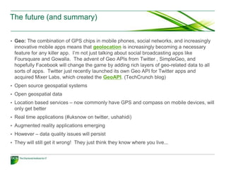
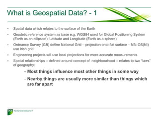
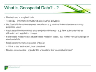
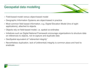
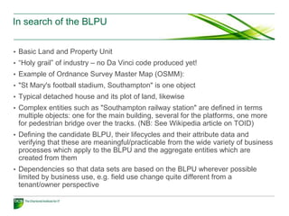
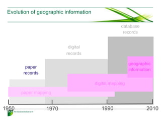
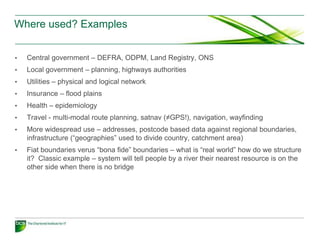
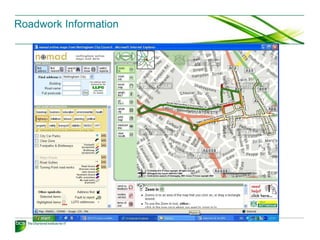
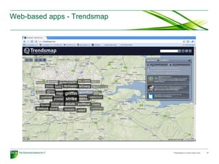
The document introduces geospatial systems and data. It discusses how geospatial data relates to locations on Earth and can be structured as vector or raster maps. Geospatial systems allow for capture, storage, and analysis of spatial data. Examples of geospatial system applications include use by central government, local government, and utilities. Standards and privacy concerns are also addressed. The future of geospatial is discussed as increasingly incorporating open data, location-based services, social networking, and augmented reality applications on mobile devices.
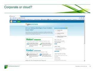
ILWIS is an acronym for the Integrated Land and Water Information System.
It is a Geographic Information System (GIS) with Image Processing capabilities. ILWIS has been developed by the International Institute for Aerospace Survey and Earth Sciences (ITC), Enschede, The Netherlands.
ILWIS is an acronym for the Integrated Land and Water Information System.
It is a Geographic Information System (GIS) with Image Processing capabilities. ILWIS has been developed by the International Institute for Aerospace Survey and Earth Sciences (ITC), Enschede, The Netherlands.
Introduction to GIS - Basic spatial concepts - Coordinate Systems - GIS and Information Systems – Definitions – History of GIS - Components of a GIS – Hardware, Software, Data, People, Methods – Proprietary and open source Software - Types of data – Spatial, Attribute data- types of attributes – scales/ levels of measurements.
operating system
,
os
,
what is an os?
,
types of os
,
logical architecture of a computer system
,
basic task perform by os
,
task switching
,
utility software
,
main functions of an os
Geospatial solutions for creating a smart cityShristi Paudel
Smart city is a concept for sustainable cities. Geomatics/Geospatial technologies play a major role in creating a smart city; they act like the foundation for smart city. This presentation highlights the importance and role of different sectors of geospatial field in a smart city. The presentation was presented in an open presentation competition on the theme 'Applied engineering technology' and was awarded the first prize.
This is lecture of Advanced GIS (ITM 524), MSc in Information Technology for Natural Resources Management, Bogor Agricultural University.
This topics covered: Internet & World Wide Web, Web Mapping, Internet GIS, Web Mapping Services Model, Spatial Data Infrastructure.
Computer is an electronic device that is designed to work with Information. The term computer is derived from the Latin term ‘computare’, this means to calculate or programmable machine. Computer cannot do anything without a Program. It represents the decimal numbers through a string of binary digits. The Word 'Computer' usually refers to the Center Processor Unit plus Internal memory.
Charles Babbage is called the "Grand Father" of the computer. The First mechanical computer designed by Charles Babbage was called Analytical Engine. It uses read-only memory in the form of punch cards.
Computer is an advanced electronic device that takes raw data as input from the user and processes these data under the control of set of instructions (called program) and gives the result (output) and saves output for the future use. It can process both numerical and non-numerical (arithmetic and logical) calculations.
A computer is an electronic machine, capable of performing basic operations like addition, subtraction, multiplication, division, etc. The computer is also capable of storing information, which can be used later. It can process millions of instructions in a few seconds and at the same time with high accuracy. Hence a computer can be defined as an automatic electronic machine for performing calculations or controlling operations that are expressible in numerical or logical terms. Computers are very accurate and save time by performing the assigned task very fast. They don’t get bored.
ESWC2015 - Tutorial on Publishing and Interlinking Linked Geospatial DataKostis Kyzirakos
In this tutorial we present the life cycle of linked geospatial data and we focus on two important steps: the publication of geospatial data as RDF graphs and interlinking them with each other. Given the proliferation of geospatial information on the Web many kinds of geospatial data are now becoming available as linked datasets (e.g., Google and Bing maps, user-generated geospatial content, public sector information published as open data etc.). The topic of the tutorial is related to all core research areas of the Semantic Web (e.g., semantic information extraction, transformation of data into RDF graphs, interlinking linked data etc.) since there is often a need to re-consider existing core techniques when we deal with geospatial information. Thus, it is timely to train Semantic Web researchers, especially the ones that are in the early stages of their careers, on the state of the art of this area and invite them to contribute to it.
In this tutorial we give a comprehensive background on data models, query languages, implemented systems for linked geospatial data, and we discuss recent approaches on publishing and interlinking geospatial data. The tutorial is complemented with a hands-on session that will familiarize the audience with the state-of-the-art tools in publishing and interlinking geospatial information.
http://event.cwi.nl/eswc2015-geo/
This primer is one in a series of Operational Policy documents being developed by GeoConnections. It is intended to inform Canadian Geospatial Data Infrastructure (CGDI) stakeholders about the nature and scope of digital geospatial data archiving and preservation and the realities, challenges and good practices of related operational policies.
Enabling Access to Big Geospatial Data with LocationTech and Apache projectsRob Emanuele
LocationPowers OGC BigGeoData 2016
This presentation will discuss tools in the open source landscape that are used to handle big geospatial data. In particular, we will focus on how Apache frameworks such as Spark and Accumulo are "geospatially enabled" by four projects: GeoTrellis, GeoWave, GeoMesa, and GeoJinni. These four projects all participate in LocationTech, a working group under the Eclipse Foundation. In particular, we will discuss how each of these LocationTech technologies implement spatial indexing (e.g. by using space filling curves) in order to provide quick access to data, and other common themes among the four projects. Attendees should walk away from this presentation understanding important parts of the Apache big data ecosystem, a set of LocationTech projects that belong to the cutting edge of enabling those Apache project's handling of geospatial data, as well as some solutions to common problems when dealing with large geospatial data.
STATVIEW: a web platform for visualisation and dissemination of statistical d...ALESSANDRO CAPEZZUOLI
STATVIEW represents a useful open source tool that can be conveniently shared among NSOs for analysing, visualising and sharing cartographic data in a machine-readable format.
Defining Digital Earth as a virtual representation of all digital information with a geospatial component, this geography attempts to delineate the scope and elements of Digital Earth. The framework for this geography is a set of layers applicable to describing an information system. From bottom to top the layers are physical, data, information, knowledge, decisions and actions. Conclusions of this geography are that some technologies are sufficient for a Digital Earth to come into existence, but some technologies, in particular in the upper layers, need to be developed. Three conclusions are listed in this abstract.
In the physical and data layers, the explosive growth of Internet provides access to much Digital Earth data. However, the bandwidth necessary for high-end Digital Earth clients will not be widely deployed for some time. In the near term it will be necessary to have Digital Earth access points in public places like museums where high bandwidth is available.
Digital Earth information volume is estimated by assuming a fraction of all digital information that has a geospatial component. Estimates place the total volume of recorded information at several thousand petabytes, i.e., several exabytes. It has been regularly postulated in the geographic community that half or more of all information has a geospatial component. Even though we will soon have the capacity to digitally record this volume of information, most of of it will never be looked at by a human. Tools are needed for auto-summarization, distilling the information into knowledge with lower volume and higher semantic content.
To allow decisions and actions based on the knowledge of Digital Earth requires analysis of the knowledge using tools particular to the geospatial domain. As Digital Earth will exist in a distributed service environment based on standards for interoperability, the standards must address the particulars of geospatial semantics. Syntax standards for transporting semantic information (e.g., XML) have been defined and extended with geospatial structures. Standards for achieving shared understandings ("domain semantics") are yet to be developed. Beyond domain semantics, the validity of chaining services on geospatial features ("process semantics") is less developed.
What is GIS ?
Dimensions Modeling in GIS ?
GIS Models real word(Raster, Vector)
GIS Challenges ? Data and Tech.
GIS Functionality
Building information modeling (BIM) ?
GIS Components
Spatial Data
Welcome to our ultimate guide to Geographical Information System (GIS). Discover how GIS revolutionizes data analysis, mapping.
Explore the comprehensive guide to Geographical Information System (GIS). Learn about GIS benefits, applications, and implementation. Click here to uncover the potential.
A Geographical Information System (GIS) is a computer-based tool used to capture, store, manipulate, analyse, and present spatial or geographic data. It combines various types of data such as maps, satellite imagery, aerial photographs, and tabular data to create layers of information that can be visualized and analysed in relation to their geographic location.
GIS technology allows users to explore, interpret, and understand patterns and relationships within geographic data. It provides a framework for organizing and managing data, enabling users to query and retrieve specific information based on spatial and non-spatial attributes. GIS can be used in various fields, including urban planning, natural resource management, environmental assessment, transportation, agriculture, and emergency management
PostGIS is a spatial extension for PostgreSQL
PostGIS aims to be an “OpenGIS Simple Features for SQL” compliant spatial database
I am the principal developer
The Use of GIS in Local Government - The City of MonashSteven Truman
The City of Monash as a case study in the use of Geographic Information Systems (GIS) and geographic data in Local government. The city of Monash is located in the south eastern suburbs of Melbourne, Victoria, Australia.
Accelerate your Kubernetes clusters with Varnish CachingThijs Feryn
A presentation about the usage and availability of Varnish on Kubernetes. This talk explores the capabilities of Varnish caching and shows how to use the Varnish Helm chart to deploy it to Kubernetes.
This presentation was delivered at K8SUG Singapore. See https://feryn.eu/presentations/accelerate-your-kubernetes-clusters-with-varnish-caching-k8sug-singapore-28-2024 for more details.
Securing your Kubernetes cluster_ a step-by-step guide to success !KatiaHIMEUR1
Today, after several years of existence, an extremely active community and an ultra-dynamic ecosystem, Kubernetes has established itself as the de facto standard in container orchestration. Thanks to a wide range of managed services, it has never been so easy to set up a ready-to-use Kubernetes cluster.
However, this ease of use means that the subject of security in Kubernetes is often left for later, or even neglected. This exposes companies to significant risks.
In this talk, I'll show you step-by-step how to secure your Kubernetes cluster for greater peace of mind and reliability.
Generating a custom Ruby SDK for your web service or Rails API using Smithyg2nightmarescribd
Have you ever wanted a Ruby client API to communicate with your web service? Smithy is a protocol-agnostic language for defining services and SDKs. Smithy Ruby is an implementation of Smithy that generates a Ruby SDK using a Smithy model. In this talk, we will explore Smithy and Smithy Ruby to learn how to generate custom feature-rich SDKs that can communicate with any web service, such as a Rails JSON API.
Encryption in Microsoft 365 - ExpertsLive Netherlands 2024Albert Hoitingh
In this session I delve into the encryption technology used in Microsoft 365 and Microsoft Purview. Including the concepts of Customer Key and Double Key Encryption.
JMeter webinar - integration with InfluxDB and GrafanaRTTS
Watch this recorded webinar about real-time monitoring of application performance. See how to integrate Apache JMeter, the open-source leader in performance testing, with InfluxDB, the open-source time-series database, and Grafana, the open-source analytics and visualization application.
In this webinar, we will review the benefits of leveraging InfluxDB and Grafana when executing load tests and demonstrate how these tools are used to visualize performance metrics.
Length: 30 minutes
Session Overview
-------------------------------------------
During this webinar, we will cover the following topics while demonstrating the integrations of JMeter, InfluxDB and Grafana:
- What out-of-the-box solutions are available for real-time monitoring JMeter tests?
- What are the benefits of integrating InfluxDB and Grafana into the load testing stack?
- Which features are provided by Grafana?
- Demonstration of InfluxDB and Grafana using a practice web application
To view the webinar recording, go to:
https://www.rttsweb.com/jmeter-integration-webinar
Kubernetes & AI - Beauty and the Beast !?! @KCD Istanbul 2024Tobias Schneck
As AI technology is pushing into IT I was wondering myself, as an “infrastructure container kubernetes guy”, how get this fancy AI technology get managed from an infrastructure operational view? Is it possible to apply our lovely cloud native principals as well? What benefit’s both technologies could bring to each other?
Let me take this questions and provide you a short journey through existing deployment models and use cases for AI software. On practical examples, we discuss what cloud/on-premise strategy we may need for applying it to our own infrastructure to get it to work from an enterprise perspective. I want to give an overview about infrastructure requirements and technologies, what could be beneficial or limiting your AI use cases in an enterprise environment. An interactive Demo will give you some insides, what approaches I got already working for real.
GraphRAG is All You need? LLM & Knowledge GraphGuy Korland
Guy Korland, CEO and Co-founder of FalkorDB, will review two articles on the integration of language models with knowledge graphs.
1. Unifying Large Language Models and Knowledge Graphs: A Roadmap.
https://arxiv.org/abs/2306.08302
2. Microsoft Research's GraphRAG paper and a review paper on various uses of knowledge graphs:
https://www.microsoft.com/en-us/research/blog/graphrag-unlocking-llm-discovery-on-narrative-private-data/
LF Energy Webinar: Electrical Grid Modelling and Simulation Through PowSyBl -...DanBrown980551
Do you want to learn how to model and simulate an electrical network from scratch in under an hour?
Then welcome to this PowSyBl workshop, hosted by Rte, the French Transmission System Operator (TSO)!
During the webinar, you will discover the PowSyBl ecosystem as well as handle and study an electrical network through an interactive Python notebook.
PowSyBl is an open source project hosted by LF Energy, which offers a comprehensive set of features for electrical grid modelling and simulation. Among other advanced features, PowSyBl provides:
- A fully editable and extendable library for grid component modelling;
- Visualization tools to display your network;
- Grid simulation tools, such as power flows, security analyses (with or without remedial actions) and sensitivity analyses;
The framework is mostly written in Java, with a Python binding so that Python developers can access PowSyBl functionalities as well.
What you will learn during the webinar:
- For beginners: discover PowSyBl's functionalities through a quick general presentation and the notebook, without needing any expert coding skills;
- For advanced developers: master the skills to efficiently apply PowSyBl functionalities to your real-world scenarios.
Slack (or Teams) Automation for Bonterra Impact Management (fka Social Soluti...Jeffrey Haguewood
Sidekick Solutions uses Bonterra Impact Management (fka Social Solutions Apricot) and automation solutions to integrate data for business workflows.
We believe integration and automation are essential to user experience and the promise of efficient work through technology. Automation is the critical ingredient to realizing that full vision. We develop integration products and services for Bonterra Case Management software to support the deployment of automations for a variety of use cases.
This video focuses on the notifications, alerts, and approval requests using Slack for Bonterra Impact Management. The solutions covered in this webinar can also be deployed for Microsoft Teams.
Interested in deploying notification automations for Bonterra Impact Management? Contact us at sales@sidekicksolutionsllc.com to discuss next steps.
Essentials of Automations: Optimizing FME Workflows with ParametersSafe Software
Are you looking to streamline your workflows and boost your projects’ efficiency? Do you find yourself searching for ways to add flexibility and control over your FME workflows? If so, you’re in the right place.
Join us for an insightful dive into the world of FME parameters, a critical element in optimizing workflow efficiency. This webinar marks the beginning of our three-part “Essentials of Automation” series. This first webinar is designed to equip you with the knowledge and skills to utilize parameters effectively: enhancing the flexibility, maintainability, and user control of your FME projects.
Here’s what you’ll gain:
- Essentials of FME Parameters: Understand the pivotal role of parameters, including Reader/Writer, Transformer, User, and FME Flow categories. Discover how they are the key to unlocking automation and optimization within your workflows.
- Practical Applications in FME Form: Delve into key user parameter types including choice, connections, and file URLs. Allow users to control how a workflow runs, making your workflows more reusable. Learn to import values and deliver the best user experience for your workflows while enhancing accuracy.
- Optimization Strategies in FME Flow: Explore the creation and strategic deployment of parameters in FME Flow, including the use of deployment and geometry parameters, to maximize workflow efficiency.
- Pro Tips for Success: Gain insights on parameterizing connections and leveraging new features like Conditional Visibility for clarity and simplicity.
We’ll wrap up with a glimpse into future webinars, followed by a Q&A session to address your specific questions surrounding this topic.
Don’t miss this opportunity to elevate your FME expertise and drive your projects to new heights of efficiency.
UiPath Test Automation using UiPath Test Suite series, part 3DianaGray10
Welcome to UiPath Test Automation using UiPath Test Suite series part 3. In this session, we will cover desktop automation along with UI automation.
Topics covered:
UI automation Introduction,
UI automation Sample
Desktop automation flow
Pradeep Chinnala, Senior Consultant Automation Developer @WonderBotz and UiPath MVP
Deepak Rai, Automation Practice Lead, Boundaryless Group and UiPath MVP
2. Agenda
• What is geospatial data and which systems process it?
• Data modelling issues regarding geospatial data
• In search of the BLPU
• Map data
• Geo-parsers/gazetteers/metadata
• Applications
• Standards
• Corporate or cloud?
• The end of privacy?
• Future directions - Location Based Services, social networking applications
• Conclusion – 2010 the year of “geo”
3. What is Geospatial Data? - 1
• Spatial data which relates to the surface of the Earth
• Geodetic reference system as base e.g. WGS84 used for Global Positioning System
(Earth as an ellipsoid), Latitude and Longitude (Earth as a sphere)
• Ordnance Survey (GB) define National Grid – projection onto flat surface – NB: OS(NI)
use Irish grid
• Engineering projects will use local projections for more accurate measurements
• Spatial relationships – defined around concept of neighbourhood – relates to two “laws”
of geography:
- Most things influence most other things in some way
- Nearby things are usually more similar than things which
are far apart
4. What is Geospatial Data? - 2
• Unstructured – spaghetti data
• Topology – information structured as networks, polygons
• GeoSpatial information requires metadata – e.g. minimal information such as map
projection used
• GeoSpatial information may also temporal modelling – e.g. farm subsidies vary as
utilisation and legislation change
• Field-based model versus object-based model of space, e.g. rainfall versus buildings on
which rain falls
• GeoSpatial information requires ontology
– What is the “real world”, how classified
• Relates to semantics - important to understand the “conceptual model”
5. Geospatial data modelling
• Field-based model versus object-based model
• Geographic Information Systems are object-based in practice
• Most common field based information, e.g. Digital Elevation Model (line of sight
applications), attached to objects
• Objects rely on field-based model, i.e. spatial co-ordinates
• Initiatives such as Digital National Framework encourage organisations to structure data
on references to objects, not re-capture and duplicate data
• GeoSpatial equivalent of “referential integrity”
• Nevertheless duplication, lack of (referential) integrity is common place and hard to
eradicate
6. In search of the BLPU
• Basic Land and Property Unit
• “Holy grail” of industry – no Da Vinci code produced yet!
• Example of Ordnance Survey Master Map (OSMM):
• "St Mary's football stadium, Southampton" is one object
• Typical detached house and its plot of land, likewise
• Complex entities such as "Southampton railway station" are defined in terms
multiple objects: one for the main building, several for the platforms, one more
for pedestrian bridge over the tracks. (NB: See Wikipedia article on TOID)
• Defining the candidate BLPU, their lifecycles and their attribute data and
verifying that these are meaningful/practicable from the wide variety of business
processes which apply to the BLPU and the aggregate entities which are
created from them
• Dependencies so that data sets are based on the BLPU wherever possible
limited by business use, e.g. field use change quite different from a
tenant/owner perspective
7. Evolution of geographic information
database
records
digital
records
geographic
paper
information
records
digital mapping
paper mapping
1950 1970 1990 2010
8. Vector map data
• Large scale
– Ordnance Survey Master Map
– UKMap (The GeoInformation Group)
Open source
- Open Street Map – very successful crowd-sourcing project, now being used in Haiti to
provide current maps for emergency services (as it can be easily edited)
- Postcode and medium scale OS data – subject to DCLG consultation, part of Smarter
Government initiative
• Road network data
– ITN (part of Master Map)
– Navteq, TeleAtlas (now part of larger groups Nokia and TomTom respectively)
• Address data
– NLPG versus Address Layer 2 (Master Map) versus UKMap addresses...
Presentation to insert name here 8
9. Raster map data
• Scanned ortho-rectified map or map-based data – metadata is co-ordinates, projection,
extent
• For example Google Maps/Google Earth, Microsoft Virtual Earth
• Traditionally stored outside the database as external files, analogous to vector data
storage, e.g. Oracle 10g GeoRaster
• Data stored as BLOBs, metadata required regarding number of bytes per pixel,
compression algorithms and so on
• Benefits limited as “intelligence” in map requires interpretation
• Still limited progress on map-based pattern recognition – there are semi-automated
solutions from companies such as 1Spatial
10. What are GeoSpatial Systems?
• Known as Geographic Information Systems, Spatial Information Systems
– Rebadged as “geospatial” or now “geo” – shorter name more mainstream!
• Enables capture, modelling, storage, retrieval, sharing, manipulation and analysis of
geographically referenced data
• Database is at the heart – as is “attribute” data
• Model developing – perhaps GeoSpatial data better seen as “attribute” of alphanumeric
business information
• Presentation does not have to be map-based in all cases
• Key element is spatial indexing – uses different techniques to alphanumeric indexing,
makes different demands for database storage and management
11. Structured geo-database
Relational Spatial
Time/Engineering
Database Data
CRM (Attribute data) (proprietary format)
Systems
Real
ERP Spatially extended RDBMS
-Complex data types for spatial data
-Computational geometry
-Spatial indexing
-DDL and DML extensions
12. Where used? Examples
• Central government – DEFRA, ODPM, Land Registry, ONS
• Local government – planning, highways authorities
• Utilities – physical and logical network
• Insurance – flood plains
• Health – epidemiology
• Travel - multi-modal route planning, satnav (≠GPS!), navigation, wayfinding
• More widespread use – addresses, postcode based data against regional boundaries,
infrastructure (“geographies” used to divide country, catchment area)
• Fiat boundaries verus “bona fide” boundaries – what is “real world” how do we structure
it? Classic example – system will tell people by a river their nearest resource is on the
other side when there is no bridge
18. Standards
• ISO TC211 – range of ISO geospatial standards
– Best known are WMS/WFS – not web services but similar
• CEN TC/287 – adopts them in Europe
• BSi IST/036 – UK standards committee
• All likely to be swept away as geospatial becomes mainstream by general web standards:
– Web services
– WMS and WFS now developing web services wrapper...
– W3C Geolocation API see an example at:
http://www.edparsons.com/maps/geolocation.html
• Your Location is: 51.591697, -0.172635, within 150m on Thu Jan 21 2010 13:06:24 GMT+0000 (GMT Standard
Time)
• This page demonstrates basic usage of the Geolocation API.
– Note: this requires client-side permission – but only required once!
Presentation to insert name here 18
20. Web-based systems
• Structured applications
• Google Earth, Bing Maps, Yahoo Maps (GYM) – all different APIs
• Mapstraction API (http://www.mapstraction.com/) provides generic API
• Mashups – new sources of data available including data.gov.uk launched today,
data.london.gov.uk launched recently by GLA
• Unstructured data – not least photographs on flickr and other sites
• Increasing use of location for search engine results, relevant to both desktop and mobile
uses
• World wide wild west of unstructured data
• Increasing use of systems to control, coordinate and make this accessible
• Geo-enabled semantic web – raises issues of ontology
• www.metacarta.com – provide web-based Geographic Text Search (GTS), has the ability
to confine searches by geography and retrieve information that it detects using the
keywords, and then displays this information geographically on a map interface
21. Geo-parsers/
gazetteers/metadata
• Geo-parsers: identify spatial tags (geo-tags) in data
• Context sensitivity and patterns of usage required
• E.g. Jordan (country) != Jordan (Katie Price)
• Can see examples at:
• http://unlock.edina.ac.uk/ (Edina unlock uses open source and OS data)
• http://developer.yahoo.com/geo/placemaker/ (Yahoo Place Maker)
• Relies on and populates gazetteer of associated names
• Emerging standards for geo-parsing, e.g. Open GIS Consortium looking at:
– Gazetteer service
– Geo-coder service
– Web services (WMS/WFS)
22. Privacy - They know where you live
• MetaCarta – technology provider to cloud computing but also...
• MetaCarta(R), Inc., a leading provider of geographic intelligence, announced
today that it had won a one-year contract with … the Department of Homeland
Security [which] identifies and assesses current and future threats to the
homeland, maps those threats against the nation's vulnerabilities, issues timely
warnings and takes preventative and protective action… The product
automatically identifies geographic references using advanced natural language
processing (NLP) from any type of unstructured content in a customer's
archives such as email, web pages, newswires or cables. It assigns a latitude
and longitude to these references so that users can analyze their text archives
using geographic maps, keywords and time as filters. The results of a query are
displayed on a map with icons representing the locations found in the natural
language text of the documents and as a text results list. Both the icons and text
summaries are hyperlinked to the documents they represent.
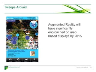
• Social networking – they know where you tweet...
23. Tweeps Around
Augmented Reality will
have significantly
encroached on map
based displays by 2015
Presentation to insert name here 23
24. The future (and summary)
• Geo: The combination of GPS chips in mobile phones, social networks, and increasingly
innovative mobile apps means that geolocation is increasingly becoming a necessary
feature for any killer app. I’m not just talking about social broadcasting apps like
Foursquare and Gowalla. The advent of Geo APIs from Twitter , SimpleGeo, and
hopefully Facebook will change the game by adding rich layers of geo-related data to all
sorts of apps. Twitter just recently launched its own Geo API for Twitter apps and
acquired Mixer Labs, which created the GeoAPI. (TechCrunch blog)
• Open source geospatial systems
• Open geospatial data
• Location based services – now commonly have GPS and compass on mobile devices, will
only get better
• Real time applications (#uksnow on twitter, ushahidi)
• Augmented reality applications emerging
• However – data quality issues will persist
• They will still get it wrong! They just think they know where you live...
25. Issues – data availability and quality
• Crowd sourced data – flickr, social networking
• Mobile devices – also provide real time data
• Critical issue – understand data and metadata
Presentation to insert name here 25
26. The future...
• Success of semantic-based approach yet to be determined, experience with geospatial
data indicates there are significant complexities based around our representations of the
“real world”
• One issue is clear – increasingly less privacy, location is already accessible through
mobile phones and linking this to other data can provide significant intelligence
information
• Summary:
– in corporate world you can and now should be exploiting geospatial data both for
conventional uses and for web 2.0 applications (citizen involvement, crowd sourcing
etc)
– In unstructured world, geo is becoming key element for searches, impacts mobile
applications
– In social networking world, geo is becoming a key consideration especially for mobile
applications
Presentation to insert name here 26