GPS is a global satellite navigation system maintained by the US that provides location and time information to users worldwide with an accuracy of 5 meters. NavIC is India's regional satellite navigation system developed by ISRO to focus on India and surrounding areas. It uses dual frequency bands to provide more accurate positioning of 20 meters for civilian use. NavIC aims to support navigation applications for mariners, vehicles and disaster management across India.
Global Positioning System . It gives the idea about Global Positioning System. It is one type of satellite made by India. Which means Indian reasearch Navigation 🧭
NAVIC (Navigation with Indian Constellation)Mohan Kanni
A small presentation on NAVIC (Navigation with Indian Constellation) on what it consists of and its uses to the country from an ordinary person to commercial business and Military usage For National Security Purposes. Having a Indigenous Navigation system is Vital to country like India due to various prospects.
IRNSS is an independent regional navigation satellite system developed by India with an operational name of NAVIC ("SAILOR") or "navigator" in Sanskrit, Hindi and many other Indian languages.
The Indian Regional Navigation Satellite System or IRNSS is an ingenuously developed Navigation Satellite System that is used to provide accurate real-time positioning and timing services over India and region extending to 1500 km around India. The fully deployed IRNSS system consists of 3 satellites in GEO orbit and 4 satellites in GSO orbit, approximately 36,000 km altitude above earth surface.However, the full system comprises nine satellites, including two on the ground as stand-by.The requirement of such a navigation system is driven because access to foreign government-controlled global navigation satellite systems is not guaranteed in hostile situations, as happened to the Indian military depending on American GPS during the Kargil War.The IRNSS would provide two services, with the Standard Positioning Service open for civilian use, and the Restricted Service (an encrypted one) for authorized users (including the military).
A Comprehending overview of how a GPS (global positioning system) works with a set of satellites ready to provide precision status on location to base station (cell) of user.
#Share the Knowledge
This content introduces the Global Navigation Satellite System (GNSS), its example, earth observation orbit types, coordinate systems, GNSS time system, converting height (ellipsoidal, geoid, orthometric heights) and various GNSS applications.
NAVIC (Navigation with Indian Constellation) is an Operational name of IRNSS.
Independent Indian Regional Navigation Satellite System
provide accurate position information service to users in India as well as the region extending up to 1500 km from its boundary.
In this Programme there are two levels of service/access to data
1. Standard Positioning Service (SPS)
-which is provided to all the users
2. Restricted Service (RS)
- which is an encrypted service provided only to the authorised users like Indian Security forces.
• NAVIC has total of 7 satellites of which 3 are in GEO (GeoStationary) orbit and 4 are in GSO (GeoSynchronous) orbit.
This is the presentation on GPS AIDED GEO AUGMENTED NAVIGATION (GAGAN) developed by India and thus becoming the 4th country after USA, Europe & Japan to have its own SBAS (Satellite Based Augmented Navigation).
Indian Regional Navigational Satellite System (IRNSS)Yelendher Reddy
1. THE BEGINNING
2. WHY?
3. SERVICES
4. ARCHITECTURE
5. SATELLITES
6. IRNSS COVERAGE
7. BENEFITS
Approved by Government of India in May 2006.
The total cost of the project is expected to be ₹1420 crore (US$209 million).
the full system comprises nine satellites.
3 satellites in GEO orbit.
4 satellites in GSO orbit.
2 on the ground as stand-by.
Third country in the world to have it’s own navigational system.
INDIAN REGIONAL NAVIGATIONAL SATELLITE SYSTEM (IRNSS)Yelendher Reddy
1. THE BEGINNING
2. WHY?
3. SERVICES
4. ARCHITECTURE
5. SATELLITES
6. IRNSS COVERAGE
7. BENEFITS
Approved by Government of India in May 2006.
The total cost of the project is expected to be ₹1420 crore (US$209 million).
the full system comprises nine satellites.
3 satellites in GEO orbit.
4 satellites in GSO orbit.
2 on the ground as stand-by.
Third country in the world to have it’s own navigational system.
Indian military depending on American GPS during Wars.
Global Positioning System for College SeminarShaeq Ahmad
Seminar on Global Positioning System
•GPS Segments
•Indian Regional Navigational Satellite System (IRNSS)
•GPS Usage in Palm Jumeirah Archipelago Construction
Navigation Aid for Travelers using NavIC Receiverijtsrd
In India, many navigation devices and applications are based on American GPS system originally known as GPS Global Positioning System which is the most accurate among all the navigation systems and serves the entire globe. The navigation and positioning applications would be at halt, experiences void and the whole infrastructure and organization based on GPS which are currently in use would be collapsed, if America denies access for GPS service. To fill the void and to overcome dependency, India has developed its own regional navigation system originally named as IRNSS Indian Regional Navigational Satellite System and later renamed as NavIC Navigation using Indian Constellation . In the near future all the applications based on GPS service are to be replaced with NavIC. Various attempts have been made to ease travelling across the globe. A number of applications and smart devices have been developed using GPS with different objectives. In this paper, an attempt has been made to develop a smart portable device using NavIC receiver to assist in travel across India. Using the IRNSS receiver we will get the current location of the person and the person then need to select the destination location from a list of places via GUI. Our application will then direct the person to the destination giving the route map and travel distance. Shashank Keerthy Kumar | Yashaswini C Reddy | Varsha Hulamani | Shwetha BS "Navigation Aid for Travelers using NavIC Receiver" Published in International Journal of Trend in Scientific Research and Development (ijtsrd), ISSN: 2456-6470, Volume-5 | Issue-1 , December 2020, URL: https://www.ijtsrd.com/papers/ijtsrd38028.pdf Paper URL : https://www.ijtsrd.com/engineering/electronics-and-communication-engineering/38028/navigation-aid-for-travelers-using-navic-receiver/shashank-keerthy-kumar
Transcript: Selling digital books in 2024: Insights from industry leaders - T...BookNet Canada
The publishing industry has been selling digital audiobooks and ebooks for over a decade and has found its groove. What’s changed? What has stayed the same? Where do we go from here? Join a group of leading sales peers from across the industry for a conversation about the lessons learned since the popularization of digital books, best practices, digital book supply chain management, and more.
Link to video recording: https://bnctechforum.ca/sessions/selling-digital-books-in-2024-insights-from-industry-leaders/
Presented by BookNet Canada on May 28, 2024, with support from the Department of Canadian Heritage.
Connector Corner: Automate dynamic content and events by pushing a buttonDianaGray10
Here is something new! In our next Connector Corner webinar, we will demonstrate how you can use a single workflow to:
Create a campaign using Mailchimp with merge tags/fields
Send an interactive Slack channel message (using buttons)
Have the message received by managers and peers along with a test email for review
But there’s more:
In a second workflow supporting the same use case, you’ll see:
Your campaign sent to target colleagues for approval
If the “Approve” button is clicked, a Jira/Zendesk ticket is created for the marketing design team
But—if the “Reject” button is pushed, colleagues will be alerted via Slack message
Join us to learn more about this new, human-in-the-loop capability, brought to you by Integration Service connectors.
And...
Speakers:
Akshay Agnihotri, Product Manager
Charlie Greenberg, Host
LF Energy Webinar: Electrical Grid Modelling and Simulation Through PowSyBl -...DanBrown980551
Do you want to learn how to model and simulate an electrical network from scratch in under an hour?
Then welcome to this PowSyBl workshop, hosted by Rte, the French Transmission System Operator (TSO)!
During the webinar, you will discover the PowSyBl ecosystem as well as handle and study an electrical network through an interactive Python notebook.
PowSyBl is an open source project hosted by LF Energy, which offers a comprehensive set of features for electrical grid modelling and simulation. Among other advanced features, PowSyBl provides:
- A fully editable and extendable library for grid component modelling;
- Visualization tools to display your network;
- Grid simulation tools, such as power flows, security analyses (with or without remedial actions) and sensitivity analyses;
The framework is mostly written in Java, with a Python binding so that Python developers can access PowSyBl functionalities as well.
What you will learn during the webinar:
- For beginners: discover PowSyBl's functionalities through a quick general presentation and the notebook, without needing any expert coding skills;
- For advanced developers: master the skills to efficiently apply PowSyBl functionalities to your real-world scenarios.
The Art of the Pitch: WordPress Relationships and SalesLaura Byrne
Clients don’t know what they don’t know. What web solutions are right for them? How does WordPress come into the picture? How do you make sure you understand scope and timeline? What do you do if sometime changes?
All these questions and more will be explored as we talk about matching clients’ needs with what your agency offers without pulling teeth or pulling your hair out. Practical tips, and strategies for successful relationship building that leads to closing the deal.
GDG Cloud Southlake #33: Boule & Rebala: Effective AppSec in SDLC using Deplo...James Anderson
Effective Application Security in Software Delivery lifecycle using Deployment Firewall and DBOM
The modern software delivery process (or the CI/CD process) includes many tools, distributed teams, open-source code, and cloud platforms. Constant focus on speed to release software to market, along with the traditional slow and manual security checks has caused gaps in continuous security as an important piece in the software supply chain. Today organizations feel more susceptible to external and internal cyber threats due to the vast attack surface in their applications supply chain and the lack of end-to-end governance and risk management.
The software team must secure its software delivery process to avoid vulnerability and security breaches. This needs to be achieved with existing tool chains and without extensive rework of the delivery processes. This talk will present strategies and techniques for providing visibility into the true risk of the existing vulnerabilities, preventing the introduction of security issues in the software, resolving vulnerabilities in production environments quickly, and capturing the deployment bill of materials (DBOM).
Speakers:
Bob Boule
Robert Boule is a technology enthusiast with PASSION for technology and making things work along with a knack for helping others understand how things work. He comes with around 20 years of solution engineering experience in application security, software continuous delivery, and SaaS platforms. He is known for his dynamic presentations in CI/CD and application security integrated in software delivery lifecycle.
Gopinath Rebala
Gopinath Rebala is the CTO of OpsMx, where he has overall responsibility for the machine learning and data processing architectures for Secure Software Delivery. Gopi also has a strong connection with our customers, leading design and architecture for strategic implementations. Gopi is a frequent speaker and well-known leader in continuous delivery and integrating security into software delivery.
Slack (or Teams) Automation for Bonterra Impact Management (fka Social Soluti...Jeffrey Haguewood
Sidekick Solutions uses Bonterra Impact Management (fka Social Solutions Apricot) and automation solutions to integrate data for business workflows.
We believe integration and automation are essential to user experience and the promise of efficient work through technology. Automation is the critical ingredient to realizing that full vision. We develop integration products and services for Bonterra Case Management software to support the deployment of automations for a variety of use cases.
This video focuses on the notifications, alerts, and approval requests using Slack for Bonterra Impact Management. The solutions covered in this webinar can also be deployed for Microsoft Teams.
Interested in deploying notification automations for Bonterra Impact Management? Contact us at sales@sidekicksolutionsllc.com to discuss next steps.
UiPath Test Automation using UiPath Test Suite series, part 3DianaGray10
Welcome to UiPath Test Automation using UiPath Test Suite series part 3. In this session, we will cover desktop automation along with UI automation.
Topics covered:
UI automation Introduction,
UI automation Sample
Desktop automation flow
Pradeep Chinnala, Senior Consultant Automation Developer @WonderBotz and UiPath MVP
Deepak Rai, Automation Practice Lead, Boundaryless Group and UiPath MVP
Key Trends Shaping the Future of Infrastructure.pdfCheryl Hung
Keynote at DIGIT West Expo, Glasgow on 29 May 2024.
Cheryl Hung, ochery.com
Sr Director, Infrastructure Ecosystem, Arm.
The key trends across hardware, cloud and open-source; exploring how these areas are likely to mature and develop over the short and long-term, and then considering how organisations can position themselves to adapt and thrive.
Neuro-symbolic is not enough, we need neuro-*semantic*Frank van Harmelen
Neuro-symbolic (NeSy) AI is on the rise. However, simply machine learning on just any symbolic structure is not sufficient to really harvest the gains of NeSy. These will only be gained when the symbolic structures have an actual semantics. I give an operational definition of semantics as “predictable inference”.
All of this illustrated with link prediction over knowledge graphs, but the argument is general.
UiPath Test Automation using UiPath Test Suite series, part 4DianaGray10
Welcome to UiPath Test Automation using UiPath Test Suite series part 4. In this session, we will cover Test Manager overview along with SAP heatmap.
The UiPath Test Manager overview with SAP heatmap webinar offers a concise yet comprehensive exploration of the role of a Test Manager within SAP environments, coupled with the utilization of heatmaps for effective testing strategies.
Participants will gain insights into the responsibilities, challenges, and best practices associated with test management in SAP projects. Additionally, the webinar delves into the significance of heatmaps as a visual aid for identifying testing priorities, areas of risk, and resource allocation within SAP landscapes. Through this session, attendees can expect to enhance their understanding of test management principles while learning practical approaches to optimize testing processes in SAP environments using heatmap visualization techniques
What will you get from this session?
1. Insights into SAP testing best practices
2. Heatmap utilization for testing
3. Optimization of testing processes
4. Demo
Topics covered:
Execution from the test manager
Orchestrator execution result
Defect reporting
SAP heatmap example with demo
Speaker:
Deepak Rai, Automation Practice Lead, Boundaryless Group and UiPath MVP
JMeter webinar - integration with InfluxDB and GrafanaRTTS
Watch this recorded webinar about real-time monitoring of application performance. See how to integrate Apache JMeter, the open-source leader in performance testing, with InfluxDB, the open-source time-series database, and Grafana, the open-source analytics and visualization application.
In this webinar, we will review the benefits of leveraging InfluxDB and Grafana when executing load tests and demonstrate how these tools are used to visualize performance metrics.
Length: 30 minutes
Session Overview
-------------------------------------------
During this webinar, we will cover the following topics while demonstrating the integrations of JMeter, InfluxDB and Grafana:
- What out-of-the-box solutions are available for real-time monitoring JMeter tests?
- What are the benefits of integrating InfluxDB and Grafana into the load testing stack?
- Which features are provided by Grafana?
- Demonstration of InfluxDB and Grafana using a practice web application
To view the webinar recording, go to:
https://www.rttsweb.com/jmeter-integration-webinar
2. Global Positioning System
GPS (Global Positioning System) tracks the entire globe and
is maintained by the USA.
GPS is a Space based Global navigation Satellite system that
provides location and time information.
Freely accessible by anyone with a GPS receiver.
The GPS had a position accuracy of 5 meters.
GPS is easy to navigate as it tracks and tells the direction,
position ..etc to the User.
3. Navigation with Indian Constellation
(NavIC )
Navic is the operational name of the Indian Regional
Navigation Satellite System (IRNSS) developed by ISRO.
There are currently Seven IRNSS satellites in
geosynchronous and geostationary orbits.
Navic has been designed to focus especially on India and
adjoining regions 1500 Kms (930 mi) around it, with plans
for further extension around India.
4. NavIC Services…
NavIC will provide two types of Services
Standard Positioning Service to all users
Encrypted Restricted Service to authorized users(like
Military).
NavIC will provide drivers and other users in India with
visual and voice navigation.
Its primary beneficiaries will be Indian mariners and
fishermen, who are being provided with NavIC handsets.
5. NavIC System Supports…
NavIC is designed for a position accuracy better than 20
meters in India.
Navic uses a different frequency band and Integrating
NavIC also requires hardware changes on the chipset. So
NavIC Support cannot be extended to older phones.
The first phone in India with NavIC support is Realme X50
Pro 5G
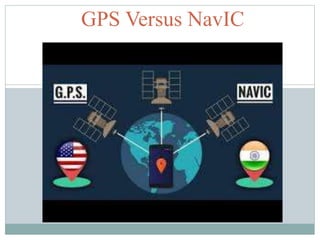
6. GPS versus NavIC
GPS NavIC
GPS or Global Positioning System
tracks the entire globe and is
maintained by the USA.
Navic is the operational name of the
Indian Regional Navigation Satellite
System (IRNSS) developed by ISRO,
INDIA.
First Satellite Launch : 1978 First Satellite Launch : 2013
GPS uses a single frequency band (L
band ).
NavIC satellites use dual frequency
bands :: L5 band (1176.45 MHz) and S
band (2492.028 MHz),
GPS makes calculations a bit more
complex due to single frequency band.
NavIC system is relatively more
accurate due to dual frequency bands .
7. GPS versus NavIC
GPS NavIC
Lifetime of each Satellite : 10 Years Lifetime of each Satellite : 12 Years
GPS requires 24 Satellites to be
operational and has around 31 satellites
in orbit.
NavIC currently consists of 8 Satellites.
Precision : 5 Meters Precision : 20 Meters for Civilian and
:10 Meters for Military
8. Applications of NavIC
Terrestrial, Aerial and Marine navigation
Disaster Management
Geodetic Data Capture
Precise Timing ad Mapping
Vehicle Tracking and fleet Management.