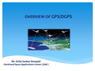
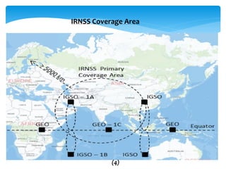
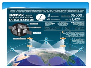
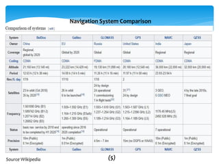
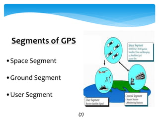
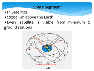
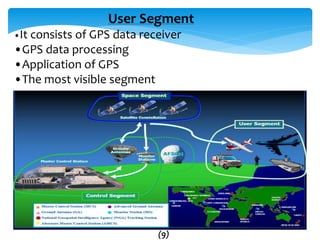
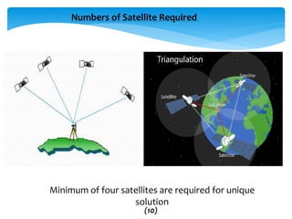
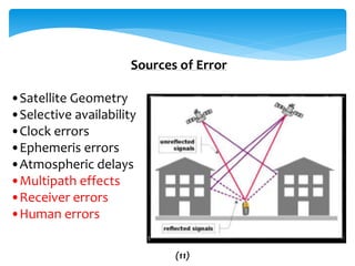
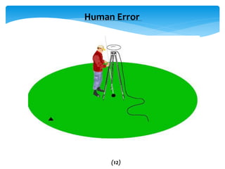
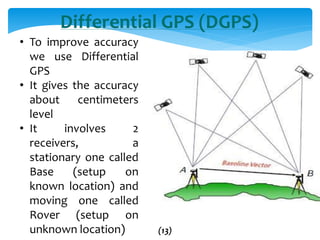
Mr. Girija Sankar Senapati
Jharkhand Space Applications Center (JSAC)
OVERVIEW OF GPS/DGPS
 Overview of GPS/ other Navigation System
 Navigation Principles
 Constellation
 GPS Errors
 Differential GPS/DGPS
 Surveying methods and integration with GIS
themes Application case studies
 Comparisons of different navigation systems
Contents
(1)
GNSS(Global Navigation Satellite Systems)
Although you may already be familiar
with the term "GPS", you may not have heard
the term "GNSS" which is used to describe.
“The GNSS is a network of satellites that
continuously transmits coded information,
which makes it possible to precisely identify
locations on earth by measuring distance
from the satellites”.
(2)
GNSS(Global Navigation Satellite Systems)
The collection of Satellite positioning systems that are now operating or
planned.
Global Navigation satellite systems
Few GNSS examples
•NAVSTAR GPS (United States)
•GLONASS (Russia)
•Galileo (European Union)
•Compass/BeiDou-2 & BeiDou-3(2020) (China)
Regional Navigation satellite systems
IRNSS
(Indian Regional Navigation Satellite System)
•NAVIC(NAVigation with Indian Constellation)
•An autonomous regional satellite navigation system that is being set up by
India
BeiDou-1(China)
QZSS (Japan)
GAGAN
The GPS-aided GEO augmented navigation (GAGAN) is an implementation of a regional satellite-based
augmentation system (SBAS) by the Indian government. It is a system to improve the accuracy of a GNSS
receiver by providing reference signals. The AAI's efforts towards implementation of operational SBAS can be
viewed as the first step towards introduction of modern Communication, navigation and surveillance/Air Traffic
Management system over Indian airspace (3)
IRNSS Coverage Area
(4)
Source Wikipedia
Navigation System Comparison
(5)
GSAT-10 / GSAT-15
GAGAN
(6)
Segments of GPS
•Space Segment
•Ground Segment
•User Segment
(7)
Space Segment
•24 Satellites
•20200 Km above the Earth
•Every satellite is visible from minimum 2
ground stations
(8)
User Segment
•It consists of GPS data receiver
•GPS data processing
•Application of GPS
•The most visible segment
(9)
Numbers of Satellite Required
Minimum of four satellites are required for unique
solution
(10)
Sources of Error
•Satellite Geometry
•Selective availability
•Clock errors
•Ephemeris errors
•Atmospheric delays
•Multipath effects
•Receiver errors
•Human errors
(11)
Human Error
(12)
Differential GPS (DGPS)
• To improve accuracy
we use Differential
GPS
• It gives the accuracy
about centimeters
level
• It involves 2
receivers, a
stationary one called
Base (setup on
known location) and
moving one called
Rover (setup on
unknown location) (13)
Differential GPS (DGPS)
Methodology Of DGPS Survey
1. Static ( No Limit)
2. Post Processed Kinematic (PPK) (Up to 10 Km.
Aerial Distance)
3. Real Time Kinematic (RTK) (SIM, Free Licence &
Restricted Licence)
4. RTX (Latest Technology) (No Limit)
(14)
USES OF DIFFERENT PROJECT
2. Demarcation Forest Boundary and exit data captured
3. Demarcation Revenue Boundary and exit data captured
4. Demarcation Mining Boundary and exit data captured
5. River Cross-section survey
6. NLRMP / DILRMP Survey
7. Road / Canal / Pipeline survey
8. Vehicle tracking
9. Dredging Survey cutting & filling survey
(15)
Single Point GPS Observation
(16)
Construction of GCP
(17)
Trimble Business Center V2.9
(18)
Basics of Global Positioning System

Basics of Global Positioning System

  • 1.
    Mr. Girija SankarSenapati Jharkhand Space Applications Center (JSAC) OVERVIEW OF GPS/DGPS
  • 2.
     Overview ofGPS/ other Navigation System  Navigation Principles  Constellation  GPS Errors  Differential GPS/DGPS  Surveying methods and integration with GIS themes Application case studies  Comparisons of different navigation systems Contents (1)
  • 3.
    GNSS(Global Navigation SatelliteSystems) Although you may already be familiar with the term "GPS", you may not have heard the term "GNSS" which is used to describe. “The GNSS is a network of satellites that continuously transmits coded information, which makes it possible to precisely identify locations on earth by measuring distance from the satellites”. (2)
  • 4.
    GNSS(Global Navigation SatelliteSystems) The collection of Satellite positioning systems that are now operating or planned. Global Navigation satellite systems Few GNSS examples •NAVSTAR GPS (United States) •GLONASS (Russia) •Galileo (European Union) •Compass/BeiDou-2 & BeiDou-3(2020) (China) Regional Navigation satellite systems IRNSS (Indian Regional Navigation Satellite System) •NAVIC(NAVigation with Indian Constellation) •An autonomous regional satellite navigation system that is being set up by India BeiDou-1(China) QZSS (Japan) GAGAN The GPS-aided GEO augmented navigation (GAGAN) is an implementation of a regional satellite-based augmentation system (SBAS) by the Indian government. It is a system to improve the accuracy of a GNSS receiver by providing reference signals. The AAI's efforts towards implementation of operational SBAS can be viewed as the first step towards introduction of modern Communication, navigation and surveillance/Air Traffic Management system over Indian airspace (3)
  • 5.
  • 7.
  • 8.
  • 9.
    Segments of GPS •SpaceSegment •Ground Segment •User Segment (7)
  • 10.
    Space Segment •24 Satellites •20200Km above the Earth •Every satellite is visible from minimum 2 ground stations (8)
  • 11.
    User Segment •It consistsof GPS data receiver •GPS data processing •Application of GPS •The most visible segment (9)
  • 12.
    Numbers of SatelliteRequired Minimum of four satellites are required for unique solution (10)
  • 13.
    Sources of Error •SatelliteGeometry •Selective availability •Clock errors •Ephemeris errors •Atmospheric delays •Multipath effects •Receiver errors •Human errors (11)
  • 14.
  • 15.
    Differential GPS (DGPS) •To improve accuracy we use Differential GPS • It gives the accuracy about centimeters level • It involves 2 receivers, a stationary one called Base (setup on known location) and moving one called Rover (setup on unknown location) (13)
  • 16.
    Differential GPS (DGPS) MethodologyOf DGPS Survey 1. Static ( No Limit) 2. Post Processed Kinematic (PPK) (Up to 10 Km. Aerial Distance) 3. Real Time Kinematic (RTK) (SIM, Free Licence & Restricted Licence) 4. RTX (Latest Technology) (No Limit) (14)
  • 17.
    USES OF DIFFERENTPROJECT 2. Demarcation Forest Boundary and exit data captured 3. Demarcation Revenue Boundary and exit data captured 4. Demarcation Mining Boundary and exit data captured 5. River Cross-section survey 6. NLRMP / DILRMP Survey 7. Road / Canal / Pipeline survey 8. Vehicle tracking 9. Dredging Survey cutting & filling survey (15)
  • 18.
    Single Point GPSObservation (16)
  • 19.
  • 20.