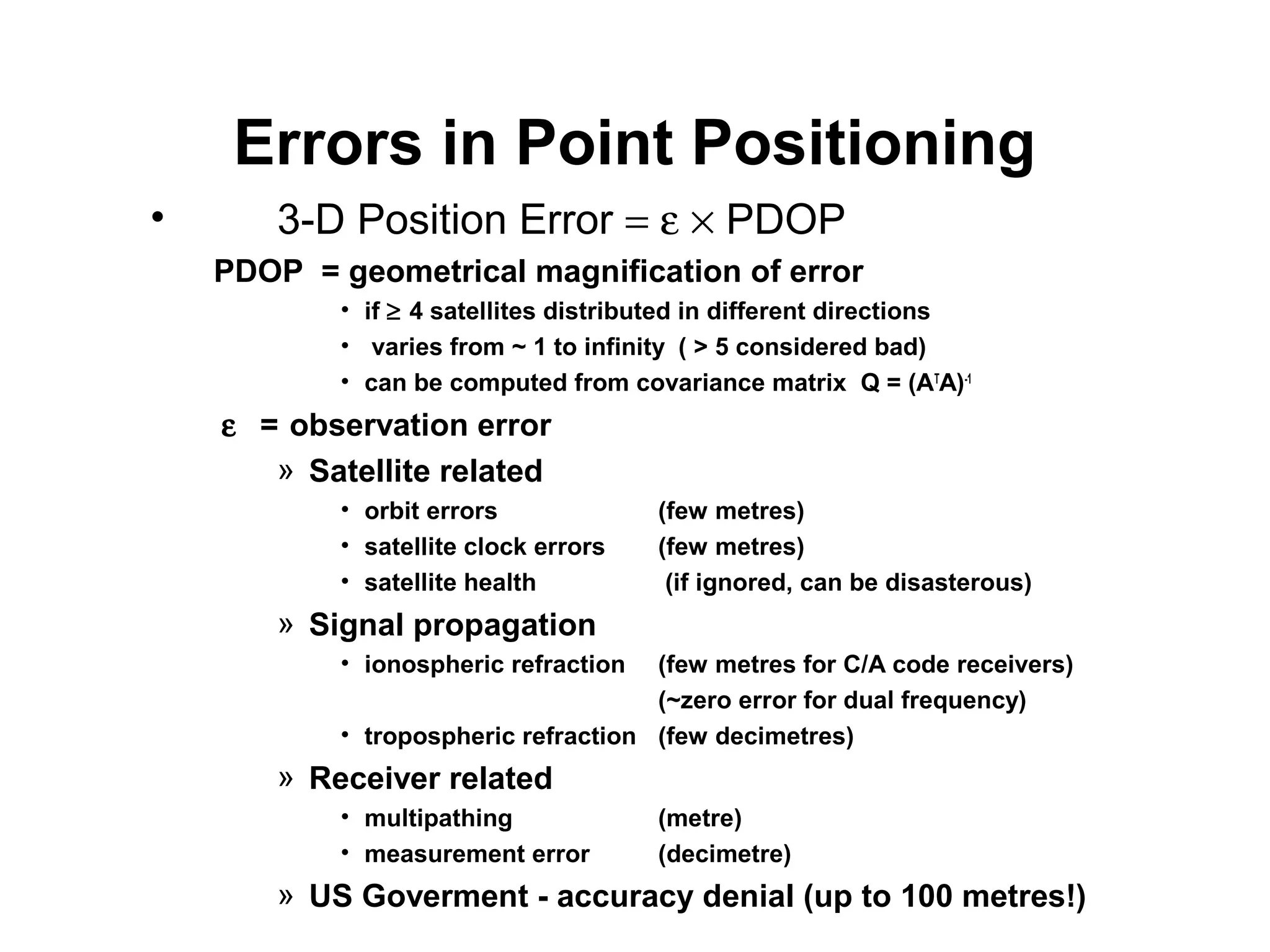
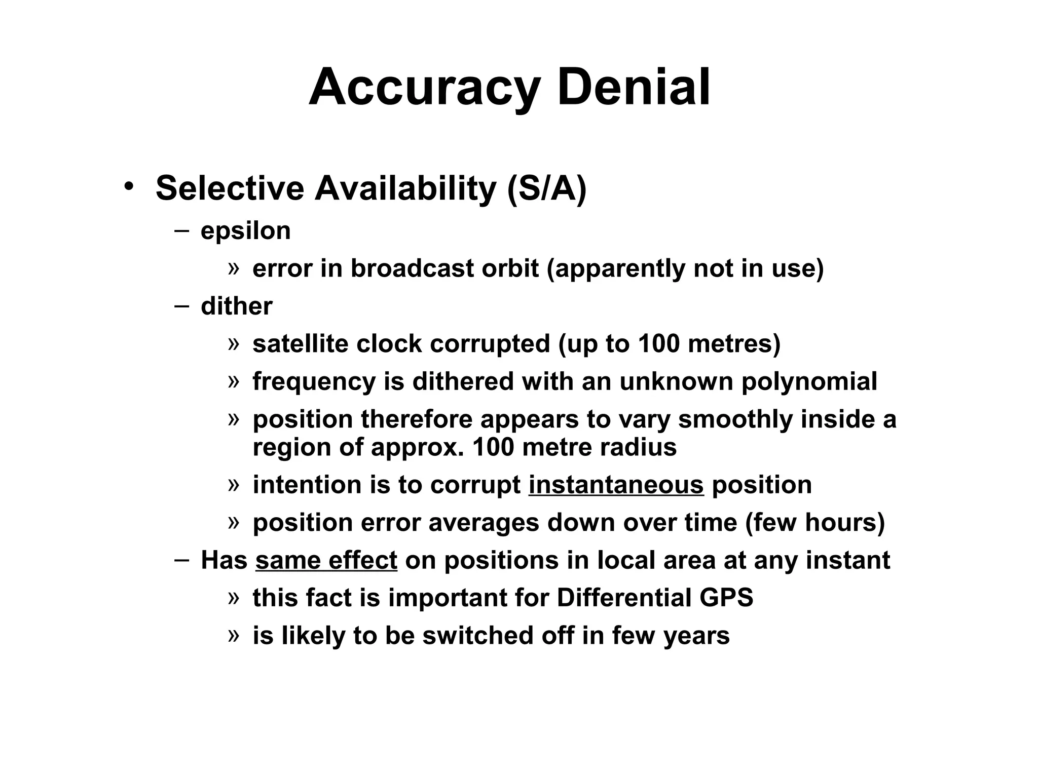
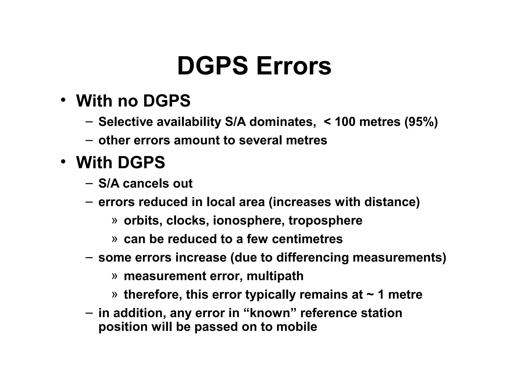
Differential GPS
J.raHUl
M.e (M.r.e) i SeMiSter
1005-12-744314
Differential GPS
• By now you should understand:
– How GPS point positioning works from first principles
• Aim of this lecture:
– To understand the basics of DIFFERENTIAL GPS
» why it is needed
» how it works
• Outline
– Rationale for Differential GPS
» Errors involved in point positioning
» Accuracy denial
– Components of DGPS
Errors in Point Positioning
• 3-D Position Error = ε × PDOP
PDOP = geometrical magnification of error
• if ≥ 4 satellites distributed in different directions
• varies from ~ 1 to infinity ( > 5 considered bad)
• can be computed from covariance matrix Q = (AT
A)-1
ε = observation error
» Satellite related
• orbit errors (few metres)
• satellite clock errors (few metres)
• satellite health (if ignored, can be disasterous)
» Signal propagation
• ionospheric refraction (few metres for C/A code receivers)
(~zero error for dual frequency)
• tropospheric refraction (few decimetres)
» Receiver related
• multipathing (metre)
• measurement error (decimetre)
» US Goverment - accuracy denial (up to 100 metres!)
Accuracy Denial
• Selective Availability (S/A)
– epsilon
» error in broadcast orbit (apparently not in use)
– dither
» satellite clock corrupted (up to 100 metres)
» frequency is dithered with an unknown polynomial
» position therefore appears to vary smoothly inside a
region of approx. 100 metre radius
» intention is to corrupt instantaneous position
» position error averages down over time (few hours)
– Has same effect on positions in local area at any instant
» this fact is important for Differential GPS
» is likely to be switched off in few years
Accuracy Denial
• Anti Spoofing (A/S)
– Under A/S, P1 and P2 unavailable for civilian positioning:
» P code on both L1 and L2 encrypted with secret W code
» resulting “P code” + “W code” = “Y code”
» some military receivers can unscramble the Y code
– What can civilians do about this?
» C/A code is not encrypted, hence we can still get a
pseudorange on L1: “C1”
» Y code is the same on L1 and L2, therefore receivers
can measure Y1−Y2 by correlating L1 with L2.
» Hence we can get “C2” = C1 − (Y1−Y2)
– “Signal to noise ratio” (SNR) is not as strong for C2 than P2
» less precise measurement
» greater multipath effect (can be > 1 metre)
Components of DGPS
• Basic principle
– Errors in position are similar for all receivers in local area
– Corrections
» Position correction
» Range correction
• Reference station
– at known coordinates (in WGS 84 reference system)
– must have good view of the sky
– transmits corrections to users in the region
• Mobile station
– typically single frequency C/A receivers with radio link
• Data links
– Low and high frequency transmitters
– “Age of correction”
DGPS Errors
• With no DGPS
– Selective availability S/A dominates, < 100 metres (95%)
– other errors amount to several metres
• With DGPS
– S/A cancels out
– errors reduced in local area (increases with distance)
» orbits, clocks, ionosphere, troposphere
» can be reduced to a few centimetres
– some errors increase (due to differencing measurements)
» measurement error, multipath
» therefore, this error typically remains at ~ 1 metre
– in addition, any error in “known” reference station
position will be passed on to mobile

DIFFERENTIAL GPS

  • 1.
    Differential GPS J.raHUl M.e (M.r.e)i SeMiSter 1005-12-744314
  • 2.
    Differential GPS • Bynow you should understand: – How GPS point positioning works from first principles • Aim of this lecture: – To understand the basics of DIFFERENTIAL GPS » why it is needed » how it works • Outline – Rationale for Differential GPS » Errors involved in point positioning » Accuracy denial – Components of DGPS
  • 3.
    Errors in PointPositioning • 3-D Position Error = ε × PDOP PDOP = geometrical magnification of error • if ≥ 4 satellites distributed in different directions • varies from ~ 1 to infinity ( > 5 considered bad) • can be computed from covariance matrix Q = (AT A)-1 ε = observation error » Satellite related • orbit errors (few metres) • satellite clock errors (few metres) • satellite health (if ignored, can be disasterous) » Signal propagation • ionospheric refraction (few metres for C/A code receivers) (~zero error for dual frequency) • tropospheric refraction (few decimetres) » Receiver related • multipathing (metre) • measurement error (decimetre) » US Goverment - accuracy denial (up to 100 metres!)
  • 4.
    Accuracy Denial • SelectiveAvailability (S/A) – epsilon » error in broadcast orbit (apparently not in use) – dither » satellite clock corrupted (up to 100 metres) » frequency is dithered with an unknown polynomial » position therefore appears to vary smoothly inside a region of approx. 100 metre radius » intention is to corrupt instantaneous position » position error averages down over time (few hours) – Has same effect on positions in local area at any instant » this fact is important for Differential GPS » is likely to be switched off in few years
  • 5.
    Accuracy Denial • AntiSpoofing (A/S) – Under A/S, P1 and P2 unavailable for civilian positioning: » P code on both L1 and L2 encrypted with secret W code » resulting “P code” + “W code” = “Y code” » some military receivers can unscramble the Y code – What can civilians do about this? » C/A code is not encrypted, hence we can still get a pseudorange on L1: “C1” » Y code is the same on L1 and L2, therefore receivers can measure Y1−Y2 by correlating L1 with L2. » Hence we can get “C2” = C1 − (Y1−Y2) – “Signal to noise ratio” (SNR) is not as strong for C2 than P2 » less precise measurement » greater multipath effect (can be > 1 metre)
  • 6.
    Components of DGPS •Basic principle – Errors in position are similar for all receivers in local area – Corrections » Position correction » Range correction • Reference station – at known coordinates (in WGS 84 reference system) – must have good view of the sky – transmits corrections to users in the region • Mobile station – typically single frequency C/A receivers with radio link • Data links – Low and high frequency transmitters – “Age of correction”
  • 7.
    DGPS Errors • Withno DGPS – Selective availability S/A dominates, < 100 metres (95%) – other errors amount to several metres • With DGPS – S/A cancels out – errors reduced in local area (increases with distance) » orbits, clocks, ionosphere, troposphere » can be reduced to a few centimetres – some errors increase (due to differencing measurements) » measurement error, multipath » therefore, this error typically remains at ~ 1 metre – in addition, any error in “known” reference station position will be passed on to mobile