Downloaded 155 times

![GSM Overview
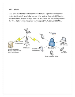
Global Systemfor Mobile Communications or GSMis the world's mostpopular
standard for mobile telephone systems. The GSMAssociation estimates that 80%
of the global mobile market uses the standard.
[1] GSM is used by over 1.5 billion people
[2] Across morethan 212 countries and territories.
[3] This ubiquity means that subscribers can usetheir phones throughoutthe
world, enabled by Internationalroaming arrangements between mobile network
operators.
GSM differs fromits predecessor technologies in that both signaling and speech
channels are digital, and thus GSM is considered a second generation (2G) mobile
phone system. The GSMstandard has been an advantageto both consumers, who
may benefit fromthe ability to Roam and switch carriers withoutreplacing
phones, and also to network operators, who can chooseequipment from many
GSM equipment vendors.](https://image.slidesharecdn.com/gpsinterfaceingsmnetwork-151010174320-lva1-app6892/85/Gps-interface-in-gsm-network-12-320.jpg)

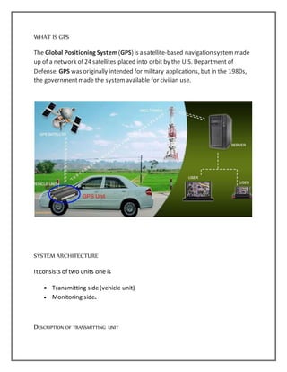
Anup Kumar submitted a seminar report on a GPS interface in a GSM network. He expressed gratitude to his guide Er. Debasish Mishra and the Head of the Electrical Engineering Department Prof. Dr. N.R. Samal for their support and guidance. The report described a vehicle tracking system that uses GPS and GSM technologies to track the location of a vehicle and transmit it to a monitoring unit via SMS. The system provides security against vehicle theft and allows owners to monitor vehicles' locations from anywhere. Potential applications include stolen vehicle recovery, fleet management, and delivery services.