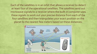
“Global Positioning System”
GPS
Introduction and Applications in Civil Engineering
Presented by – Pushpraj Choudhary
Contents
▪ Introduction
▪ Working
▪ Applications
▪ Advantages
INTRODUCTION
GPS or Global Positioning System is a network of orbiting
satellites that send precise details of their position in space back to
earth.
The signals are obtained by GPS receivers, such as navigation devices
and are used to calculate the exact position, speed and time at the
vehicles location.
The very first GPS system was developed in the 1960’s to allow ships
in the US Navy to navigate the oceans more accurately.
How GPS works
There are three parts to a GPS
system:
A constellation of between 24
and 32 solar-powered
satellites (including three
backup satellites ) orbiting
the earth in orbits at an
altitude of approximately
20000 kilometers,
A master control station and
Four control and monitoring
stations and GPS receivers
such as the one in a car.
Each of the satellites is in an orbit that allows a receiver to detect
at least four of the operational satellites.The satellites send out
microwave signals to a receiver where the built-in computer uses
these signals to work out your precise distance from each of the
four satellites and then triangulates your exact position on the
planet to the nearest few meters based on these distances.
Applications Of GPS
 SURVEYING - Many companies in India and abroad uses GPS to locate different points,
preparing contour maps, giving alignments of roads, bridges where precision is very
essential. This system gives us the accurate geographic position required for land surveying.
 NAVIGATION - It is used for navigation purposes in aircraft, ships, submarines etc
 MILITARY - It is now exceedingly used to locate the enemy targets and subsequently
hitting them by GPS information guided missiles.
 PUBLIC USES - For public use simpler version are available for locating the vehicles, the
individuals and the places, in hiking and mountaineering expeditions and other number of
applications.
Advantages Of GPS
 It helps to survey with many times greater Precision.
 This system is fast replacing with conventional methods of surveying likeTriangulation,
Traversing, etc.
 It helps to complete a Survey with lesser time and thus helps to cut down the
Completion Period.
 It Reduces the Difficulty of taking manual measurements to great extent.
 With GPS there is a very less chances of error. And this error may come only due to the
instrument malfunction.
THANKYOU
Queries Please

Global positioning system

  • 1.
    “Global Positioning System” GPS Introductionand Applications in Civil Engineering Presented by – Pushpraj Choudhary
  • 2.
    Contents ▪ Introduction ▪ Working ▪Applications ▪ Advantages
  • 3.
    INTRODUCTION GPS or GlobalPositioning System is a network of orbiting satellites that send precise details of their position in space back to earth. The signals are obtained by GPS receivers, such as navigation devices and are used to calculate the exact position, speed and time at the vehicles location. The very first GPS system was developed in the 1960’s to allow ships in the US Navy to navigate the oceans more accurately.
  • 4.
    How GPS works Thereare three parts to a GPS system: A constellation of between 24 and 32 solar-powered satellites (including three backup satellites ) orbiting the earth in orbits at an altitude of approximately 20000 kilometers, A master control station and Four control and monitoring stations and GPS receivers such as the one in a car.
  • 5.
    Each of thesatellites is in an orbit that allows a receiver to detect at least four of the operational satellites.The satellites send out microwave signals to a receiver where the built-in computer uses these signals to work out your precise distance from each of the four satellites and then triangulates your exact position on the planet to the nearest few meters based on these distances.
  • 6.
    Applications Of GPS SURVEYING - Many companies in India and abroad uses GPS to locate different points, preparing contour maps, giving alignments of roads, bridges where precision is very essential. This system gives us the accurate geographic position required for land surveying.  NAVIGATION - It is used for navigation purposes in aircraft, ships, submarines etc  MILITARY - It is now exceedingly used to locate the enemy targets and subsequently hitting them by GPS information guided missiles.  PUBLIC USES - For public use simpler version are available for locating the vehicles, the individuals and the places, in hiking and mountaineering expeditions and other number of applications.
  • 7.
    Advantages Of GPS It helps to survey with many times greater Precision.  This system is fast replacing with conventional methods of surveying likeTriangulation, Traversing, etc.  It helps to complete a Survey with lesser time and thus helps to cut down the Completion Period.  It Reduces the Difficulty of taking manual measurements to great extent.  With GPS there is a very less chances of error. And this error may come only due to the instrument malfunction.
  • 8.